Celebrating Blog’s 19th Anniversary


  Nineteen year ago I started this blog as a distraction from my father’s heart attack and slow recovery. It was late 2004 and social media & video streaming apps didn’t exist yet — or at least not widely available to the general public. Blogs were the newest means of …

Thoughts on NGA West’s Upcoming $10 Million Dollar Landscaping Project


  The new NGA West campus , Jefferson & Cass, has been under construction for a few years now. Next NGA West is a large-scale construction project that will build a new facility for the National Geospatial-Intelligence Agency in St. Louis, Missouri.This $1.7B project is managed by the U.S. Army …

Four Recent Books From Island Press


  Book publisher Island Press always impresses me with thoughtful new books written by people working to solve current problems — the subjects are important ones for urbanists and policy makers to be familiar and actively discussing. These four books are presented in the order I received them. ‘Justice and …

New Siteman Cancer Center, Update on my Cancer


  This post is about two indirectly related topics: the new Siteman Cancer Center building under construction on the Washington University School of Medicine/BJC campus and an update on my stage 4 kidney cancer. Let’s deal with the latter first. You may have noticed I’ve not posted in three months, …

Recent Articles:

Transit-Oriented Planning Eliminates 22nd Street Interchange, Reconnects Street Grid


For years I’ve been accused of being a naive dreamer, coming up with big plans without the existing market to implement. I’ve just smiled and continued sharing my long-term vision for St. Louis.

In June 2007 I wrote:

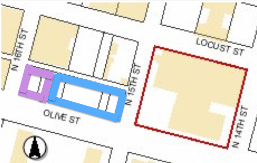
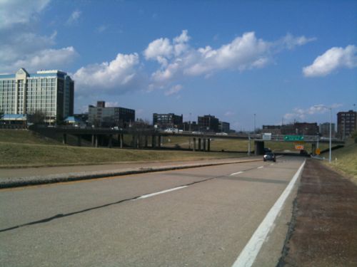
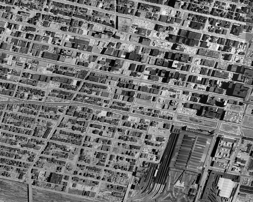
The 22nd Street Interchange, part of an abandoned highway concept from a few decades ago, needs to be ripped out with the land returned to active tax-paying use. The Missouri Dept of Transportation (MoDOT) should rework the interchange at Jefferson Ave to allow for on/off ramps in both directions and therefore eliminating the need for the current ramps at 22nd. MoDot could sell the land to fund the revisions to the highway ramps. (St. Louis Should Abandon Linear Gateway Mall Concept)

Then in December 2008 I wrote:

I picture a new bridge at I-64/40 and Jefferson Ave — one with a single point urban interchange (SPUI) and both East & West on/off ramps. Build that and then remove the 22nd interchange completely. Bring in form-based zoning codes to require a denser urban environment. Make a strong connection through the back of Union Station (between the shed & highway) so that pedestrians from this newly developable land have the opportunity to walk to Metrolink and the 14th street transit station beyond that. The fact that much of this area is already excavated and free of utility lines would simplify the construction of underground parking in new buildings. (MoDOT Needs To Put The 22nd Street Interchange On Any Wish List For Funding)

By May 2009 I noted that St. Louis’ 22nd Street Interchange Part of McKee’s Plan so it elimination would need to be worked out with him. Presumably MoDOT agrees with McKee because they’re replacing the Jefferson bridge over I-64/40 with no plans for on/off ramps to/from the east.

Then, last month, at an St. Louis Regional Transit Oriented Development Study presentation around the Union Station & Civic Center Metrolink stations the Denver-based consulting firm suggested largely what I had outlined years earlier.

Preliminary plan around Union Station, the Drury (former YMCA) and other existing buildings should be shown in the final presentation.

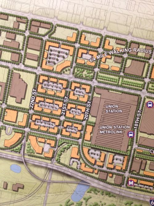
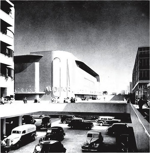
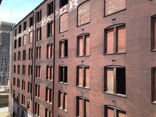
Ok, they still have on/off ramps for I-64/40 to the east, but they are compact and feed into the reconnected street grid I had advocated. The above image is preliminary, I pointed out it was missing buildings like the Drury Inn on 20th, formerly a YMCA and later a gay bar/hotel/bathhouse. Hopefully their final will be more accurate than the draft shown at the last meeting.

Still they see what I and others saw, the need to repair the street grid and fill in the gaps in the urban fabric.

Only part of a planned highway loop around downtown was built, a huge waste of land to the west of Union Station.
The 22nd Street interchange is just on/off ramps.

1958
1958 aerial of the area west & north of Union Station

This is not about trying to recreate the buildings and feel of the area prior to the demolition for the highway interchange. This is a forward-looking vision to create a walkable/urban environment for those interested in such. Some prefer the look & feel of new buildings, new sidewalks, new trees, etc. This is an opportunity to create an entirely new neighborhood largely from scratch yet have access to existing transit.

Per McKee’s plans, a few new employers could anchor the neighborhood. Workers & residents would attract restaurants, dry cleaners, and other services.

None of this is rocket science, it’s Urban Planning 101. St. Louis still needs lots of basics to rebuild the connections that were ripped out in the 20th Century.

— Steve Patterson

Readers on Infrastructure


As I expected, only a minority of readers live in a fantasyland where they think the public gets the infrastructure we want:

Pick the statement you agree with most:

  1. We get the infrastructure that makes developers the most money. 30 [42.25%]
  2. We get the infrastructure we want only if we fight for/demand better. 15 [21.13%]
  3. We get the infrastructure we get because most people don’t know other options exist. 12 [16.9%]
  4. We get the infrastructure that was commonplace years ago, but outdated today. 8 [11.27%]
  5. We get the infrastructure in our communities that most of us want and use. 5 [7.04%]
  6. Unsure/No Answer 1 [1.41%]

The rest of us know the so-called “free market” is limited by municipal zoning codes and time saver standards rather than creative thinking to respond to ever-changing demographics and preferences.

I should’ve had the top answer be one that costs developers the least rather than makes the most money, but you get the idea. To change this pattern we need to educate the public on other options so they’ll also demand better.

— Steve Patterson

My Wish List For The Next Saint Louis University President


Most likely you’ve already heard the news: Lawrence Biondi has announced he will retire as president of Saint Louis University.

The Rev. Lawrence Biondi surprised supporters and critics alike Saturday evening when he announced plans to retire from the presidency of St. Louis University.

The move follows months of campus strife that included no-confidence votes by faculty and students. (stltoday)

I’ve lived in St. Louis for nearly 23 years, most of Biondi’s 25-year tenure. I’ve witnessed the physical changes to the midtown campus along with everyone else. The public remains sharply divided on these changes. Some of us see the changes during his tenure as highly destructive and anti-urban, others view them as visionary, saving a once-dying campus.

Who’s right? Actually, both views are correct.

Biondi had a vision for the campus and was relentless in making it happen. Unfortunately, his vision was shaped by a perspective shared with many in his generation:

  1. Pedestrians stroll through park-like settings but use cars to actually get from point a to point b, pedestrians should be seperated from roads.
  2. Old urban cities are bad places with bad people, to be safe we must create physical barriers to keep them out of our space and to tell us where we shouldn’t go.
  3. Only poor people use public transit, everyone else has a car. In other words: transit brings troublesome poor folks while parking garages attracts desirable folks.
  4. Open space, with lush green lawns, solves problems.
  5. Residential, office, retail, industrial should all be separate from each other.

These views were formed in their youth, influenced by the General Motors Futurama exhibit at the 1939 World’s Fair.

The 1939 GM "Futurama" exhibit imagined intersection of 1960 with pedestrians separated from autos
The 1939 GM “Futurama” exhibit imagined intersection of 1960 with pedestrians separated from autos, click image to view 6 minute YouTube video from the 1939 New York World’s Fair (highly recommended)

My hope is the next president of Saint Louis University will reject the beliefs listed above. That he/she will instead think:

  1. The university should embrace the city, not wall it off.
  2. Supporting public transit will greatly reduce the need to take on debt to build more parking garages
  3. Thriving areas beyond campus will enrich the student experience
  4. SLU is an urban campus, the public rights-of-way (roads/sidewalks) within our boundaries should be highly active

SLU's anti-urban research building on the SE corner of Grand & Chouteau
SLU’s anti-urban research building on the SE corner of Grand & Chouteau

What is the likelihood the Board of Trustees will select someone with a viewpoint radically different from Biondi with respect to urban planning? Right, not very high…

— Steve Patterson

Potential Development Sites Along Proposed Streetcar Line, Part 1: Olive 15th-16th


The proposed streetcar from St. Louis’ central business district (CBD) to the Central West End (CWE) along Olive/Lindell is moving forward. Regular readers know I’m a streetcar advocate because of how it can increase development activity in a way no bus route ever can. I thought I’d take a close look at potential sites along the proposed route, starting with the area nearest my loft.

The block on the north side of Olive between 15th and 16th is nothing but two surface parking lots.

Looking west from 15th Street
Looking west from 15th Street, YMCA at right

The larger lot with entrance on 15th serves the building the occupies the block to the east. This building contains the administrative offices for the St. Louis Public Library and the Confluence High School. That building contains parking underneath as well as some surface parking within that block. The library owns the building and this surface parking lot.

The surface lot, shown above, doesn’t get much use. Once the streetcar line starts running there won’t be as much need for automobile parking, hopefully the library can sell the large surface overflow parking lot to a developer for new construction. This is currently subdivided into 4 parcels with addresses 1501 Olive, 1507 Olive, 1509-1529 Olive, and 1527 Olive with a total area of 26,964sf or 0.62 acres. See map.

The west end of the block is a smaller privately-owned public surface parking lot, legally divided into two parcels with addresses 1531-1533 Olive and 1535-1537 Olive. The total area of these two parcels is 11,676sf or 0.27 acres. Combine all six parcels owned by two entities and you have 38,640sf or 0.89 acres.

Purple is the smaller privately-owned lot, blue the lot owned by the library and the red outlines the building with library offices and charter high school.

The only structures on this city block are The Campbell House Museum and the 10-story YMCA. The 100 upper floor apartments have been vacant for at least 5 years now, hopefully a streetcar line will get someone interested in taking on the project. Other buildings in the area range from 1-10 floors, but most are greater than 5.

A stop is highly unlikely at 15th because the streetcar line will have a major connection at 14th, but I’d like another stop at 16th or 17th.  Even if the next stop isn’t until 18th or 19th I can see this block filled in with apartments and/or condos along with new ground-floor restaurant/retail space.

— Steve Patterson

Poll: Thoughts on Demolition of Cupples 7


South wall of the Cupples 7 warehouse

Last week the city announced the Building Commissioner will order the demolition of the  historic Cupples 7 warehouse if a savior doesn’t come foreword.

The city’s building commissioner is expected to file a demolition permit next week.

The seven story building will be demolished at the end of the month if a developer doesn’t purchase it first.(KSDK)

That’s not much time to find someone with deep pockets to save the structure. Interesting information also came out last week about finances.

Unless a new buyer emerges, the city will be out $850,000. That’s because former Treasurer Larry Williams took an option on the property from Montgomery Bank, lender to the development firm that was unable to follow through on its plan to put condos in Cupples 7. (stltoday)

It looks like Cupples 7 will be coming down because just stabilizing the structure is estimated by some to cost millions.

The poll this week seeks to find out if you support the city’s decision, vote in the right sidebar. See Saving Cupples 7: The Importance of Urban Context for more photos.

— Steve Patterson

Advertisement


[custom-facebook-feed]

Archives

Categories

Advertisement


Subscribe