Home » Featured » Recent Articles:

Pedestrian Access Route to The Cheshire Easily Blocked

The Cheshire on Clayton Road has been as we know it since the early 1960s. I hadn’t been to either the hotel or restaurant since either reopened in the last couple of years.  I’d been to both a few times over my years in St. Louis, driving each time.  I knew when I recently received the invite for an event at the Cheshire I’d take public transit and arrive as a pedestrian in my power chair. I also knew the current owner added a pedestrian route from the public sidewalk to the restaurant.

Before getting into the pedestrian access here’s a brief history:

In 1960, a man from another local family, Stephen J. Apted, bought the building and remodeled the restaurant into The Cheshire Inn, complete with authentic British art, antiques, furnishings and details. Hailing from a family of restaurateurs, Mr. Apted’s mother, Mrs. Florence Hulling, had started a comfortable cafeteria-style restaurant in the 1940?s called Miss Hulling’s which quickly grew and became a tradition in St. Louis.

Apted transformed The Cheshire Inn into one of the most popular and successful restaurants in St. Louis. A story in the St. Louis Globe Democrat on October 28, 1961 called it “the most unusual and inviting atmosphere in town.” Apted’s vision, though, was for something much larger. Legend has it that the entire Cheshire complex came from an idea developed when the Apteds visited an old tavern nestled in the back streets of London named Ye Olde Cheshire Cheese. Inspired, he chose to recreate the concept at the corner of Clayton Road and Skinker Boulevard for its proximity to Forest Park and easy highway access, a location that remains one of the property’s best attributes.

Four years after opening the new restaurant, Mr. Apted built The Cheshire Lodge and furnished it with antiques and collections from his world travels. British details were everywhere, from the long riding coats of the houseman to the English accents in the guestrooms. The glass enclosed, year-round pool/conservatory was the first of its kind in the city. The Cheshire’s horse-drawn carriage rides and double-decker bus became fixtures along the St. Louis streets. In the 1980’s the popular Fantasy Suites, including everything from the Safari Rainforest to the Treehouse at Sherwood Forest, were added to the experience. In its heyday, The Cheshire Inn & Lodge was the most popular restaurant and hotel in St. Louis.

In December 2010, the property was purchased by St. Louis-based Lodging Hospitality Management with the vision of restoring it to its former glory and updating it for today’s discriminating travelers. Over a period of seven months, the hotel underwent a multi-million dollar renovation reopening in August 2011. The result is stunning! In the fall of 2012, the historic restaurant building will re-open as well. The “new” Cheshire celebrates the great history of the hotel, preserving its charm and character while transforming it into a modern, luxury boutique hotel.

Like I said, I hadn’t been back since reopening, but I knew a pedestrian route existed. How did I know? In July a reader sent me a picture of a car blocking it!

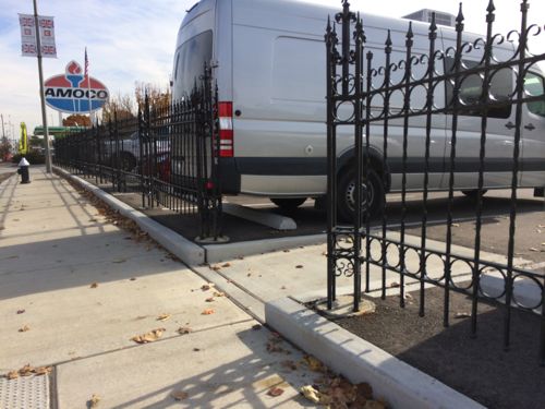
I received this image of a Porsche squeezed into the unloading space between two disabled spots in July 2013, this is also part of the route to the public sidewalk
I received this image of a Porsche squeezed into the unloading space between two disabled spots in July 2013, this is also part of the route to the public sidewalk, visible in background

I didn’t do a post using this picture because I hadn’t visited the site, I didn’t know the context. Last week I visited the Cheshire and ended up with a similar photo upon leaving. First let’s start with arrival.
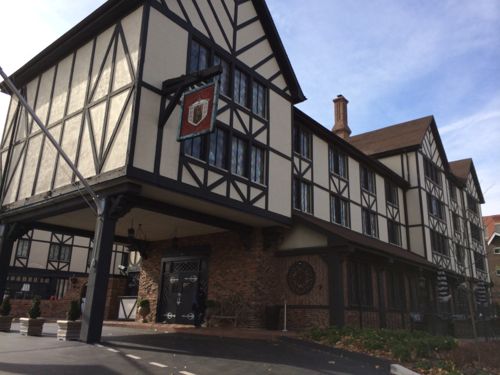
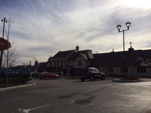
The hotel on the west half of the site is an auto drive
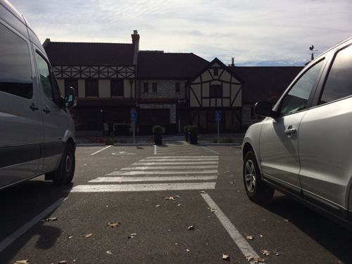
Looking toward the restaurant from the auto drive there's no clear pedestrian path
Looking toward the restaurant from the auto drive there’s no clear pedestrian path
Here's the opening I was looking for!
Here’s the opening I was looking for!
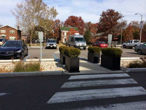
Looking toward the restaurant there's now a clearly delineated pedestrian route
Looking toward the restaurant there’s now a clearly delineated pedestrian route
Looking back toward Clayton Rd
Looking back after crossing the drive right in front of the building

This was a great way to enter the property as a pedestrian, it also helps those walking to/from their vehicles — except when an “unruly” driver  parks where they shouldn’t. Which brings me to when I was leaving…
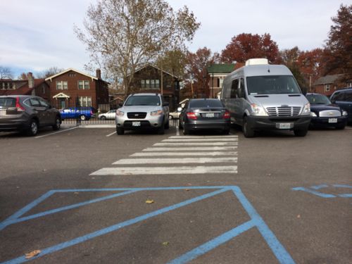
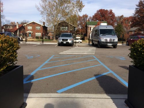
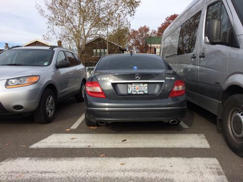
A Mercedes C-Class managed to squeeze into the space left for the pedestrian route
A closer shot, maybe the driver just didn't notice the crosswalk and opening in the fence? Not all drivers are very observant about their surroundings.
A closer shot, maybe the driver just didn’t notice the crosswalk and opening in the fence? Not all drivers are very observant about their surroundings.
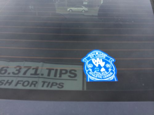
I was observant enough to notice the two police-related  items in the rear window!
I was observant enough to notice the two police-related items in the rear window!

I waited for about 10-15 minutes for the driver to come out, it was obvious to him at that point he shouldn’t have parked his car where he did. He was very apologetic, which immediately diffused my anger.

Some might say this is an enforcement issue but I say both examples of blocking the route could’ve been prevented. A bollard in the center at each point would physically prevent a car from being parked where it shouldn’t. I will make the owner, Lodging Hospitality Management, aware of the problem and my suggested solution.     LHM is also the owners of Hilton St. Louis at the Ballparks, Union Station, Seven Gables in Clayton, and other hotels.

I applaud them for having a pedestrian route, now we just need to modify it so it remains useable.

— Steve Patterson

 

Poll: How should Missouri make up the shortage in funding for roads & highways? (pick 2)

MoDOTThe Missouri Department of Transportation (MoDOT) says it needs more money than it receives:
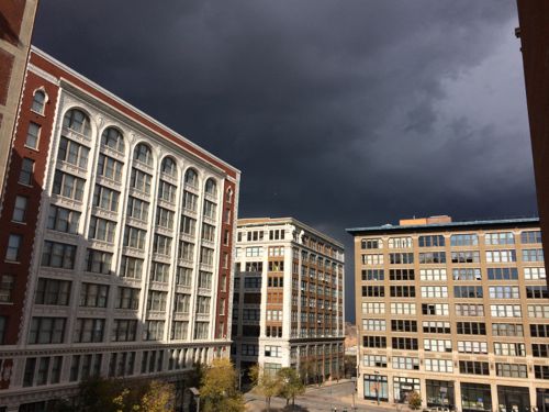
MoDOT has been warning for years that its annual highway construction budget would decline significantly as bond payments for those projects came due. That drop-off has now hit: The annual construction budget has fallen from $1.2 billion to less than $700 million, and it’s projected to drop to $425 million by 2019.

Missouri’s highway system has long depended on fuel taxes. But the report, required by federal law, said people drive less, and vehicles are more fuel-efficient. Meanwhile, inflation is increasing the cost of projects, the report noted. The price of asphalt, concrete and steel are double and triple what they were 20 years ago, when fuel taxes were last raised, the report said. (Columbia Daily Tribune)

One idea from earlier this year, a sales tax, is back in the news:

A proposal to raise a statewide one-cent sales tax to fund transportation projects could be headed to a Missouri ballot in 2014, if supporters of a new initiative petition are able to gather enough citizen support to put it there. (Kansas City Business Journal)

Other revenue options include tolls, increased licensing fees, raising the state fuel tax, and even closing roads/bridges rather than maintain/replace them. For the poll this week I’d like you to pick your top two options. Two because one alone might not be sufficient enough, the poll is at the top of the right sidebar.

 — Steve Patterson
 

Sunday’s Weather in Three Images

November 22, 2013 Environment, Featured Comments Off on Sunday’s Weather in Three Images

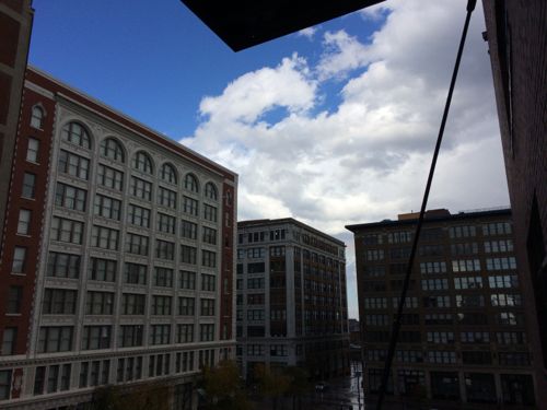
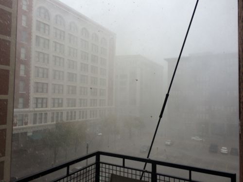
The weather last Sunday was crazy, including deadly tornados that caused extensive damage in Illinois. There was some wind damage in St. Louis, but no injuries to my knowledge.   I took three images in ten minutes that capture what I saw from our loft in downtown St. Louis:

Sunshine and dark clouds at 11:40:08am on November 17, 2013
Horizontal rain and hail at 1:44:58
Blue sky at 11:50:11am

That’s a lot to happen in just ten minutes! My heart goes out to everyone who lost family, friends, or property in these storms. Have a great weekend — no post tomorrow. New poll on Sunday though.

— Steve Patterson


Fifth Anniversary of the Gateway Transportation Center 2008, Future High-Speed Rail to Chicago’s O’Hare Airport

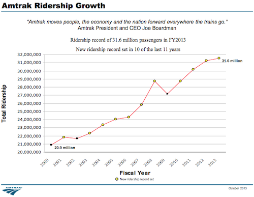
During the last five years Amtrak has seen a steady increase in ridership.

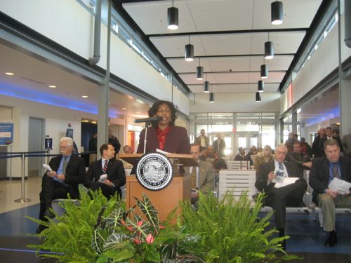
Comptroller Darlene Green speaking at the opening five years ago

The timing was perfect, although Amtrak’s FY 2009 showed a dip in ridership from 2008, it was still above 2007 levels.

Impressive growth
Impressive growth, click image to view FY 2013 ridership data from Amtrak

I’ve taken trains out of this station five times now: Kansas City (x2), Jefferson City, Bloomington-Normal, Dallas. Bloomington-Normal was Memorial weekend 2012, our station was way too small for all the rail & bus passengers that weekend. The trip to Dallas was in July 2012, I continued to Fort Worth & Oklahoma City on Amtrak, returning to St. Louis via Greyhound bus.

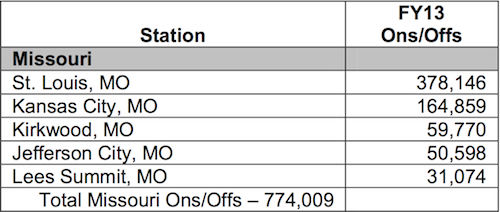
Thinking about this post I was curious how our station compared to others in Missouri, Illinois, and nationally. Turns out St. Louis had more than double the traffic as the #2 station in Missouri, Kansas City.

St. Louis accounted for almost half of Missouri's traffic
St. Louis accounted for almost half of Missouri’s traffic in FY 2013. Source: Amtrak

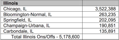
Amtrak serves 46 of the 48 continental United States, no service to Wyoming or South Dakota. Of the 46 states served, and the District of Columbia, Missouri ranked 18th in FY13, Illinois 4th.

Chicago handled 68% of the Illinois boardings in FY13
Chicago handled 68% of the Illinois boardings in FY13. St. Louis had more volume than their #2, Bloomington-Normal. The new Bloomington-Normal station opened in FY13

Clearly, our proximity to Chicago doesn’t hurt. Plus, Missouri and Illinois have both been making track upgrades which have resulted in reduced travel time. Amtrak spokesperson Marc Magliari told me the usage at the St. Louis station “has exceeded expectations.”

The Lincoln Service between Chicago and St Louis saw a 10 percent jump in passenger count, for the largest increase for any route in Illinois. It also saw a 22 percent jump in revenue. (Source)

The St. Louis station took years to be planned, funded, and opened. Now we need to plan a facility to handle high-speed rail traffic. How will a high-speed train cross the Mississippi River, a new rail bridge? Could it serve the region from a location on the Illinois side, or must it cross into Missouri? You think I’m dreaming, but I’m not:

The study concluded that a 220-mph HSR service from O’Hare Airport through downtown Chicago to Champaign-Urbana and on to St. Louis and/or Indianapolis is feasible and would be likely to cover its operating costs without subsidies. Express high-speed trains would travel from downtown Chicago to Champaign in approximately 45 minutes, to Springfield in approximately one hour and twenty minutes and to St. Louis or Indianapolis in approximately 2 hours. The study assumed that trains would run every half-hour during peak times and hourly at other times. The economic analysis of the HSR system showed potential substantial benefits to Illinois, including the creation of 409,000 to 792,000 job-years during five years of construction and creation of 10,890 to 13,820 jobs per year during the first 10 years of operation. In addition, analyses of several different cost and revenue scenarios indicated that the HSR system is expected to be operationally profitable. However, as with many large public transportation projects, the initial cost to build it is substantial and would require public and/or private sector funding to cover the initial capital cost.

Various public-private partnerships (PPP) have been successfully used to finance HSR overseas and the viability of adapting these to the US environment should be explored. An incremental or blended approach completed over a longer time period would reduce initial capital costs and provide other nearer-term transportation benefits, while simultaneously improving intercity transportation quality and travel times. This is similar to the approach commonly used internationally and should be studied further. (UIUC w/links to study)

Two hours to Chicago? Count me in!

— Steve Patterson


Readers: Sesame Street Was a Positive Influence on Their Perception of Urban Neighborhoods

November 20, 2013 Featured, Popular Culture 1 Comment

When Sesame Street debuted in November 1969 I was and wasn’t the target audience. Just shy of turning 3, I was the ideal age for the new educational show, but I was a kid in a new middle-class suburban subdivision in the sprawling city of Oklahoma City.

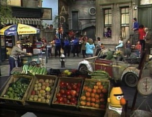
The Sesame Street set represented a very different place from where I lived

Think about the decade of the 1960s, leaders assassinated (JFK, MLK), race riots in cities, etc.  The show was targeted at poor inner-city kids, helping them learn and to feel good about their own neighborhoods — which didn’t look like Mr Roger’s Neighborhood (1968) or another show from 1969, The Brady Bunch.    I’m not the only person who’s written about growing up with Sesame Street:

Sesame Street was my first experience of a city. I had no idea where it was set when I was a kid, or even that it was in a city at all. I tended to imagine all settings as more or less equivalent to the small Midwestern city where I grew up. I was shocked as an adult to learn that Harriet the Spy, to take one example, was an Upper West Sider. As far as I was concerned, she lived down the block. I didn’t realize how centralized American culture is, how little of America Sesame Street depicts. I didn’t realize my life was considered provincial.

Sesame Street is supposed to represent a Manhattan street, which should be obvious to anyone who’s watched the program — though it wasn’t to me until I asked the show’s art director, Victor Di Napoli. I was thinking that it might be located in, oh, I don’t know, Brooklyn or Philadelphia (it’s actually filmed on a soundstage in Astoria, Queens). The folks at Sesame Street actually disagree over which specific Manhattan neighborhood the show depicts. Di Napoli, a longtime Sesame Street staffer, says it’s always been based on the Upper West Side, though Joan Ganz Cooney, Sesame Street’s founder, said during a 1994 talk at the Museum of Television and Radio in New York that she’d wanted to call the show 123 Avenue B — in the late ’60s, this now prosperous part of the East Village was called Alphabet City, and was considered part of the Lower East Side.

Whether or not I understood Sesame Street’s setting, it stuck in my head as a model for how people should live: close to one another, in a place where neighbors knew, liked, and watched out for each other, where chance encounters were common and meaningful. And I’ve sought that out repeatedly in my adult life. (How to Get to Sesame Street)

And based on the unscientific poll results many of you were also positively influenced:

Q: How did Sesame Street influence your childhood perceptions of urban neighborhoods?

  1. Positively 69 [37.91%]
  2. Very positively 66 [36.26%]
  3. Neutral 21 [11.54%]
  4. Unsure/No Answer/Not Applicable 21 [11.54%]
  5. Negatively 4 [2.2%]
  6. Very negatively 1 [0.55%]

Nearly 75% indicated Sesame Street positively or very positively influenced their perceptions of urban neighborhoods. The comments on the original post are interesting, some doubting the influence of the show and others saying they too wanted to experience such a way of living.


Advertisement


[custom-facebook-feed]

Archives

Categories

Advertisement


Subscribe