Fragmentation: One Tiny Example That Reeks
The St. Louis region ranks second in the nation for fragmentation of government, resulting in negative consequences:
With each decennial Census since 1980, we find that more people are leaving the St. Louis region than moving in. We rank very low among competing metropolitan areas in job growth and in new business starts. We have not attracted the new immigrants that other metros have done in recent decades, and our demographic profile is much less diverse than that of regions that are growing. Economic and racial disparities create chasms within the regional family. Our governmental structure is second in the nation in terms of fragmentation. (East West Gateway)
Not good, right? Often cited is the 90+ municipalities in St. Louis County but last week I discovered a small example of governmental fragmentation within the City of St. Louis.
A parking meter issue related to the Central Library was voted on by the Parking Commission last week that required me to dig into St. Louis’ history from 156+ years ago to get some answers. Huh? Yes, I had to go back to two land transactions from 1857 to try to make sense of a modern day issue. I’m still not totally clear about the legality of a recent property boundary adjustment, but first let me set up the background for you.
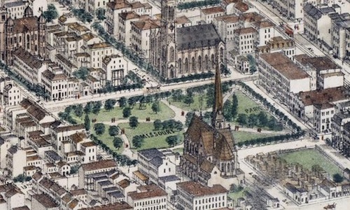
We need to start with the history of the land bounded by Olive, 14th, St. Charles St., and 13th — today the site of the Central Library and Lucas Park. The old city website about Lucas Park had great information, good thing I saved it before it was removed:
Lucas Garden was the site of a brick house built by Judge Lucas in 1820 facing the present St. Charles Street or King’s Road, as it was called. There is still a flowing spring in the Public Library basement that was the water supply for the Judge’s home.
“Desirous of contributing to the ornament and health of the City of St. Louis and at the same time to establish a permanent monument to the memory of his ancestor (father) the late Honorable John B. C. Lucas, in the shape of a public square bearing his name,” reads the deed signed by James H. and Marie E. Lucas on March 24, 1857, giving the block of land immediately north of the St. Louis Public Library to St. Louisians. The deed states further that, “This conveyance is however made with the express condition, to wit: that said public square shall forever be maintained as a public promenade for the inhabitants of the City of St. Louis.”
On the same day in 1857 that he signed the deed on Lucas Garden, James H. Lucas sold the block where the Public Library now stands to the city for the sum of $95,000.
In 1859, a board of improvement for the park was created and its development started.
Its layout caused Locust Street to be closed at 13th and the park was given an asymmetrical plan with a bandstand near the foot of Lucas Place. Sale of the buildings at the southwest corner of the park was authorized by Ordinance in 1872. From the time of the first appropriation in 1858 to 1877, $41,465 was spent on it.
The entire 6.25 acres was named Missouri Park and provided popular downtown breathing space until the erection of the St. Louis Exposition and Music Hall in 1883. Licensed to a private corporation for a period of 50 years, the ground was restored to use as a park in 1907 and designs for the Italian Renaissance inspired library building were drawn up by the famous architect Cass Gilbert. The library was completed in 1912.
Locust Street was reopened behind the Library from 13th to 14th Streets and the present sunken garden with its fountain was developed. (source)
So the city bought the block where the library stands, but the land for the park to the north was a gift to the city, with conditions. With both parcels part being public land there shouldn’t an issue over boundaries. Shouldn’t, but there is.
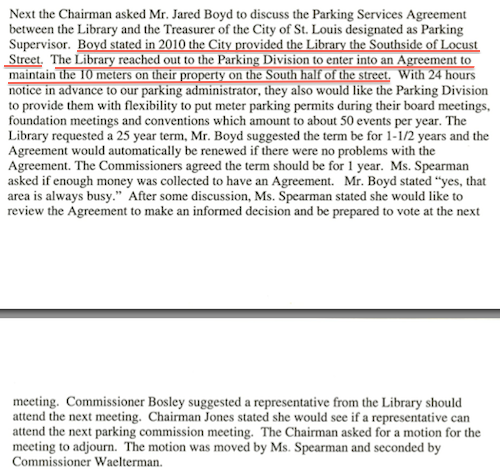
“Their property?” The city “provided” land presumably part of the 1857 grant to the city to the public library, which then generously allowed the Treasurer’s office to keep parking meters located on the new moved sidewalk. Could citizens stage a protest on this sidewalk or would the library tell citizens it isn’t public property?
At the July meeting of the Parking Commission they voted to allow the library to “hood” the ten meters on library property up to 50 times per year for special events, including board meetings.
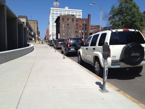
The next day I emailed all involved, informing them the library neglected to mention that two of the ten spaces are designated as disabled parking. Even if the parking meter is hooded, anyone parking in the space needs a legit disabled placard or plates. You can be sure I’ll be watching to see. Even so, I don’t like the idea of a disabled patron driving down to the library only to find every space on this side of the street taken by the library for board members.
A fragmented, reeking mess.
— Steve Patterson
 Today we have many thriving commercial streets, amazing progress is just two decades. The poll this week asks you to pick your favorite of these, here are the choices I’ve provided: