Home » Featured » Recent Articles:

Options For The Wells Goodfellow Neighborhood

July 29, 2019 Featured, MLK Jr. Drive, Neighborhoods, North City, Planning & Design Comments Off on Options For The Wells Goodfellow Neighborhood

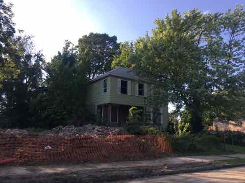
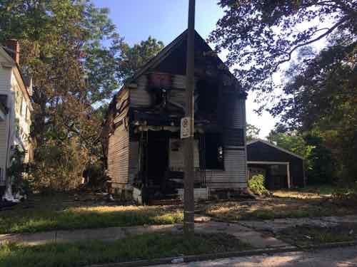
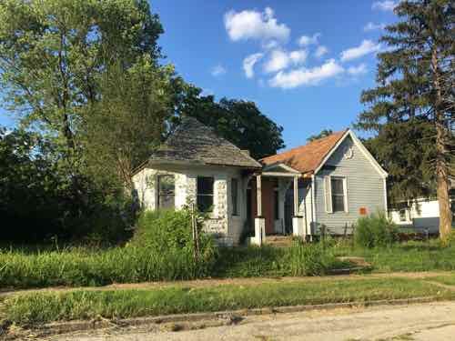
Looking at the Wells Goodfellow neighborhood last week was very depressing (see Readers Mixed On Latest Blight Removal Effort). On my visits seeing dilapidated houses being leveled I knew nobody was going to invest the money needed to have saved even one structure, let alone hundreds or the thousands throughout the city’s most sparsely populated neighborhoods.
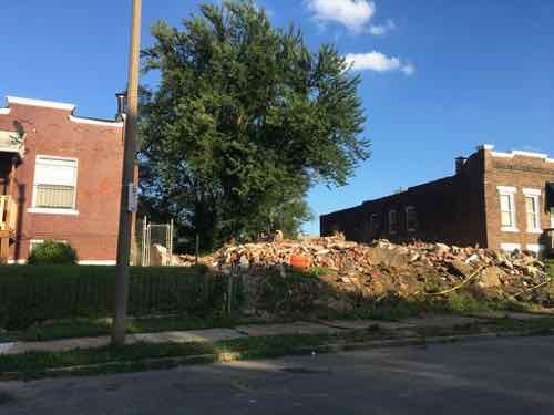
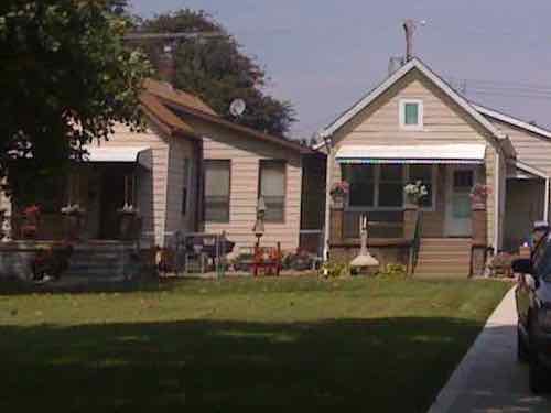
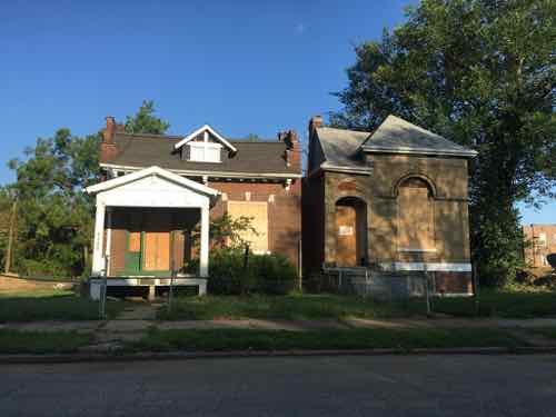
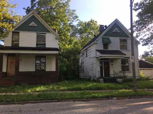
!912 Clara Ave, left, and 1904 Clara Ave are occupied, the two houses in between were just razed.

Basically the city is partnering with a new non-profit, St. Louis Blight Authority, to clear four city blocks of vacant homes, overgrown trees, trash, etc. Occupied homes in the 4-block zone would remain.

The St. Louis Blight Authority is the organization behind a project to clear a four-block area in the Wells-Goodfellow neighborhood. The organizers believe the initiative could be just the beginning of a more far-reaching program. (St. Louis Public Radio)

Today I have a few critical observations, then I’ll offer some possible solutions.

Last week I searched the Missouri Secretary of State’s business listings to find out more about this new non-profit organization — I wanted to know structure, board members, etc. Guess what — no such organization exists!  I was also unable to find a website — not even a Twitter account. Transparency is important, If we’re told a non-profit is involved that non-profit should actually exist.

Another personal observation is “Wells Goodfellow” is an awful name for a neighborhood — The “Wells” refers to 19th century transit magnate Erastus Wells, “Goodfellow” is a major north-south street — more on that later.

Wells/Goodfellow is part of an historic section known as Arlington, which takes its name from John W. Burd’s Arlington Grove subdivision of 1868. A memorable disaster in the history of the Arlington area occurred in October 1916, when the Christian Brothers College building at North Kingshighway and Easton Avenue (now Martin Luther King Drive) was destroyed by fire, one of the worst in the City’s history, taking 10 lives.

The area received its name from John W. Burd’s Arlington Grove subdivision of 1868. More subdivisions were built in the mid-1880s, with residential construction continuing until 1910. By the mid-1920s, the last of the residential subdivisions were opened. (St. Louis)

The 2013 housing development in the neighborhood uses the name Arlington Grove, so that name probably shouldn’t be used for the entire neighborhood.
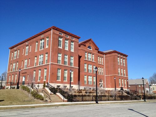
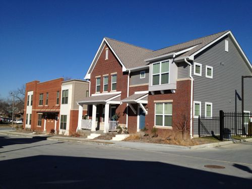
Former Arlington School in North St. Louis is now residential
The 22 new buildings have similar materials but unique designs.

Some other name with Arlington in it could be good though. Perhaps just the Arlington neighborhood?  Or something to do with land developer William Burd (1818-1885)?  Though Burd isn’t the most marketable name and I don’t know his politics.  Was he a slave owner?  His wife Eliza’s maiden name is interesting: Goodfellow.

A new name could help change perceptions for residents, property owners, workers, and outsiders. The Old North St. Louis neighborhood wouldn’t have had lots of redevelopment & new construction if it was still called Murphy-Blair.

Possible solutions for the neighborhood are varied, need to be discussed in public sessions to obtain a consensus on how to move forward. My initial brainstorming came up with the following:

  1. Do nothing
  2. Push for new infill housing
  3. Abandon the center

Let me explain each of these options.

1. Do nothing

This means nothing different, maintain the status quo. So tear down houses once they’ve become a major eyesore. Continue city services (water, sewer, trash, police, fire, etc) to those who remain.

2. Push for new infill housing

Try to get Habitat for Humanity or another entity to build new housing on vacant lots. It would probably make sense to concentrate new construction on one or two blocks at first. These lots are narrow so you’d need 2-3 lots per new single family house. Include some multi-family construction as well.  Existing infrastructure (streets, alleys, sidewalks, water, sewer, etc) may need to be upgraded on these blocks.

3. Abandon the center

This will likely be the most controversial option, here it goes. Blocks that front onto the major streets of Dr. Martin Luther King, Goodfellow, Natural Bridge, and Union would be supported. New development would occur in these blocks only — to reinforce existing corridors. Everything inside of those blocks would be, over time, cleared.  All interior streets, alleys, etc would be removed. The interior land could be used for urban agriculture or perhaps a large employer. This would create two cleared areas, one on each side of Goodfellow.
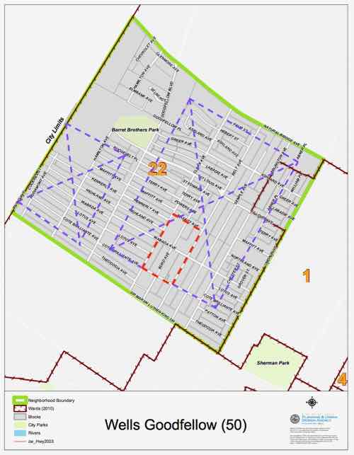
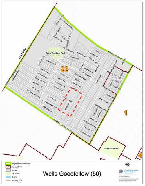
The small red area is the 4-block area where recent demolition was concentrated. Occupied residences remain in that area and on every city block. The two purple areas that could be completely cleared for urban agricultural use would be split by concentrated development fronting Goodfellow.

This solution is a drastic measure, but it or something similar might be the best hope for a neighborhood that has lost population to the point where it no longer functions. I don’t foresee anyone being forced to move or sell their home. Nature  and economics is taking a toll quickly enough.
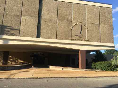
Langston Middle School is within the big purple area, but it is no longer listed as a school on the St. Louis Public Schools website. The building might be usable for hydroponics.

There are likely other buildings within the purple clear zones that could be reused within the cleared area. This area would still need water/sewer but not miles of alleys/streets/sidewalks.

Conclusion

I’ve presented a range of options, I’m sure if we put our heads together we can come up with many more.

The question I have is who will lead the effort to determine what happens next? Will it be the elderly residents who’ve stayed despite their families begging them to leave? The church leaders/parishioners who live elsewhere but drive in for Sunday services? An elected official? The nonexistent St. Louis Blight Authority?

I’m afraid the leadership vacuum will mean the “do nothing” status quo option will be selected by default.

— Steve Patterson


Sunday Poll: Should Halloween Be Moved To The Last Saturday In October?

July 28, 2019 Featured, Sunday Poll Comments Off on Sunday Poll: Should Halloween Be Moved To The Last Saturday In October?
Please vote below

This blog was started on Halloween, specifically Sunday October 31, 2004. This year, the 15th anniversary, Halloween falls on a Thursday. Last year was a Wednesday, next year Halloween falls on a Saturday.

An online petition is trying to make Saturday the permanent day of the week when Halloween occurs, regardless of the 31st.

There are lots of reasons to hate holidays: traffic, awkward family reunions, expensive gifts that would wring a tear from anyone’s wallet. But if there’s one celebration absent from all of this holiday drama, it’s Halloween.

It’s too bad that, more times than not, the sugar-laden holiday is set right in the middle of the week, when would-be revelers have to get to bed early.

But there’s a petition aiming to change that. This time, instead of demanding#Justice for A$AP Rocky or storming Area 51, it’s lobbying to bump Halloween from October 31 to the last Saturday of the month. (CNN)

Here’s a little more.

A petition on Change.org has topped its goal of 75,000 signatures to change the popular holiday to the last Saturday of October. With that milestone behind it, it’s planning to send the request on to President Trump. (Fortune)

As of yesterday more than 95,000 signatures had been gathered, the goal increased to 150,000. This is the subject of today’s poll.

Today’s poll will close at 8pm tonight.

— Steve Patterson


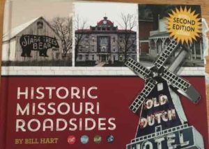
New Book — ‘Historic Missouri Roadsides, 2nd Edition’ by Bill Hart

July 26, 2019 Books, Featured, History/Preservation, Missouri Comments Off on New Book — ‘Historic Missouri Roadsides, 2nd Edition’ by Bill Hart

I’ve posted many times about day/weekend trips my husband and I have taken in small towns in Illinois & Missouri. Now we have a beautiful new hardcover book to guide us exploring more of Missouri. We especially like “two-lane” trips, as interstates are so boring.
Who hasn’t heard the call of the open road and felt the desire to get out of the city and see the beauty of the Show-Me State? Historic Missouri Roadsides offers all the history, recommendations, and itineraries you need to make the most of a picturesque trip down a two-lane road or highway. Richly illustrated with photographs from the author’s own collection, you’ll find tours of varying lengths, most beginning near Kansas City or St. Louis. Whether you’re a first-time visitor or a local “staycationer,” you’ll want to check out these tours like Route 79 along the Mississippi River or El Camino Real leading down to the Missouri Bootheel. Don’t miss the Route 24 tour through Excelsior Springs and across the state into Ralls County or a chance to see the Osage Hills and Prairies in Laclede County. Find insider’s tips on the best locally owned businesses, restaurants, and lodging along the way with character and a hometown feel. The second edition of the book offers even more destination trips including Fulton, Sedalia, the Boonslick area, the Arcadia Valley, Glasgow, and St. Joseph. Bill Hart takes the wheel and shows you the very best of the roads from St. Charles County to old Route 66. Thumb a ride through this beautiful guide to enjoy all that small town Missouri has to offer. (Reedy Press)

I like the organization, with suggested groupings of towns and interesting back routes between them. Hart suggests using a free Missouri state map, or a printed atlas. I’ll stick to using maps on my phone connected to our car’s screen — with “avoid highways” turned on.  Each area has places to eat, stay, visit, and to do — very helpful. Often our trips are based on a cafe in a town many miles away from St. Louis. Food tourism.

Thumbing though the book & scanning the index I’ve learned so much about Missouri. For example, I can finally afford to visit Paris!  Paris…Missouri.  According to Wikipedia it was platted in 1831 and named after another Paris. Paris…Kentucky.

This hardcover bill is filled with many photographs. It’s available from St. Louis’ Left-Bank Books (in stock!), St. Louis-based publisher Reedy Press, Amazon, and others.

— Steve Patterson


Readers Mixed On Latest Blight Removal Effort

July 24, 2019 Featured, History/Preservation, Neighborhoods, North City Comments Off on Readers Mixed On Latest Blight Removal Effort

Blight was in the news last week, and was the topic of the recent non-scientific Sunday Poll.

Before I get to the poll results, let’s talk about blight.

We have obsolete and blighted districts because our interest has always been centered in the newest and latest houses and subdivisions in areas of new development. As home owners have moved to successive outlying neighborhoods the earlier homes have gradually been allowed to deteriorate. No matter how great the extent of disintegration these old homes are seldom adequately repaired and are rarely torn down. This is no way to build a sound city.

The above quote isn’t from a press release about the new effort, it’s from St. Louis’ Comprehensive Plan — from 1947!

Combating blight is nothing new, but what is blight? In 1947 part of their definition was the number of housing units built prior to 1900 (82,000), number of units with an outdoor privy/outhouse (33,000), and the number of units where families shared a toilet (25,000). Today we do still have units built before 1900, but I doubt a single housing unit in the city lacks a private bathroom.

Yet blight remains, in different forms.  Dictionary.com defines blight as:

the state or result of being blighted or deteriorated; dilapidation; decay: urban blight.

St. Louis certainly has lots of deteriorated, dilapidated housing stock. For every home lovingly restored there’s probably 10 in various states of disrepair. St. Louis has struggled with this for generations.  The latest effort because it involves two wealthy individuals trying to leverage their fortunes:

Tech billionaire Jack Dorsey, a St. Louis native and co-founder and CEO of both Square Inc. and Twitter, along with Detroit native Bill Pulte, whose grandfather founded national homebuilder Pulte Homes, were paying for the demolitions — $500,000 for a pilot program to completely clear more than 130 lots in a four-block area of the northwest St. Louis neighborhood hard hit by abandonment and vacancy.

“St. Louis is a lot easier to solve,” said Pulte, who several years ago launched the Blight Authority, a similar initiative in the Detroit area. “This problem can be solved. This problem can be solved in less than 15 years…. This is just about willpower at the government and private sector level.”

So why not renovated, rather than raze? Good question. The answer is complicated, but “willpower” is an important factor. If we look at Old North St. Louis many buildings in very poor condition were stabilized for many years until they could be renovated. It was a huge effort that paid off…eventually. The neighborhood has seen considerable new infill since, from Habitat for Humanity houses to a trendy shipping container house.  Very different than when I lived in the neighborhood, 1991-1994. It helps the neighborhood is on the National Register of Historic Places.

Former Arlington School on Burd Ave in Wells Goodfellow neighborhood was converted into housing in 2012, new construction was built around it. This former school is the only building in the neighborhood on the National Register of Historic Places. Click image to see my January 2013 post from the opening of the new housing, Arlington Grove.

The Wells Goodfellow neighborhood is very different from Old North.   It’s also old, but at least a generation newer than Old North.

Wells/Goodfellow is part of an historic section known as Arlington, which takes its name from John W. Burd’s Arlington Grove subdivision of 1868. A memorable disaster in the history of the Arlington area occurred in October 1916, when the Christian Brothers College building at North Kingshighway and Easton Avenue (now Martin Luther King Drive) was destroyed by fire, one of the worst in the City’s history, taking 10 lives.

The area received its name from John W. Burd’s Arlington Grove subdivision of 1868. More subdivisions were built in the mid-1880s, with residential construction continuing until 1910. By the mid-1920s, the last of the residential subdivisions were opened. (City of St. Louis)

The location is on the far west edge of the city:

Wells Goodfellow general boundaries are defined as Natural Bridge Ave. on the North, southward to Union Blvd. on the East, westward to Dr. Martin Luther King Drive on the South, northward to the City limits on the West to Natural Bridge Ave. (City of St. Louis)

The housing stock is a mix of brick structures like we see in many neighborhoods, and wood frame structures that are becoming increasingly rare.

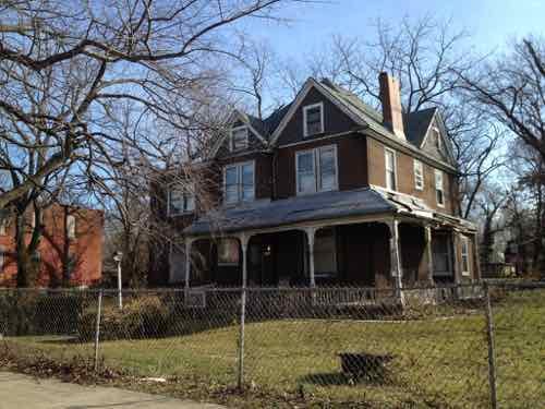
I photographed this wood-frame home at 1928 Burd Ave in the Wells Goodfellow neighborhood in January 2012. It was built in 1903.
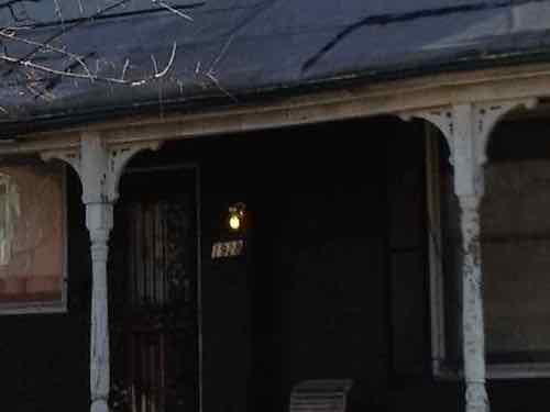
If we look closer the original porch brackets remain, the porch light is on so it was occupied.

I’m a huge fan of old wood-frame buildings, especially large homes from St. Louis’ heyday. The home above was a pile of rubble by August 2017 but not cleaned up until this month.

Across the street 1927 Burd Ave was still standing on Saturday, but both brick structures on each side had been razed. This frame house is likely gone by now, it was built in 1884.

These large frame homes are the exception for the neighborhood, most housing is smaller and modest.

!912 Clara Ave, left, and 1904 Clara Ave are occupied, the two similar houses in between were just razed.

The two that were razed were in bad shape two years ago. 1910 Clara Ave was built in 1908, was just over a thousand square feet in size. 1906 Clara Ave was built a year earlier, was just under 900 square feet. The two remaining houses are similar vintage and size.

The red dashed line shows the initial 4-block “blight elimination zone”

I’m sure the owner-occupant of one of the remaining houses is relieved to have the dilapidated neighboring structure gone. Both of the razed houses might have been technically feasible to renovate, but the economics just don’t add up in Wells Goodfellow.

There is one neighborhood in St. Louis where modest frame & masonry shotgun houses are well maintained, and often renovated. The Hill — the Italian neighborhood.

A couple of modest frame houses in The Hill neighborhood

When these aren’t renovated you’ll see a larger home built where 2-3 once existed.

Here we see a large newer home, left, on the same block as very modest houses. The house two to the right is very small.

The Hill neighborhood is of similar vintage and the housing stock was originally very similar — modest worker housing of frame or brick construction. One has had continuous investment, the other large scale abandonment.  In Wells Goodfellow few buildings are listed for sale in the MLS.  Those that are listed cost less than the average new car. Hell, less than many good used cars. Other city neighborhoods with this type of housing the unfortunate reality is closer to Wells Goodfellow than The Hill.

So when an owner-occupant dies their family sells the house to the only buyer, likely an absentee landlord. At these prices they can recoup their initial investment in less than 5 years.  The landlord rents it for as long as they can, then walk away.

This brings us back to the issue raised in the 1947 plan:

We spend $4,000,000 general tax funds annually to maintain our obsolete areas. (This sum represents the difference in cost of governmental service and tax collections annually in these areas.)

In 1947 we had overcrowding and hadn’t reached our peak population. Since then we’ve lost nearly 2/3 of our population.  Do we write off this neighborhood, or keep investing like the successful Arlington Grove housing immediacy to the south of this blight elimination zone?

In 1975, consultants from Team Four Inc. advised St. Louis planners to pursue a strategy of neighborhood triage: ‘‘conservation’’ for areas in good health, ‘‘redevelopment’’ for areas just starting to decline, and ‘‘depletion’’ for areas already in severe distress. The firm’s recommended strategy reflected the latest thinking among urban planners, but it provoked outrage among residents of the city’s predominantly black North Side, who read ‘‘depletion’’ as a promise of benign neglect. (The Trap of Triage: Lessons from the ‘‘Team Four Plan’’)

While you ponder the implications of not rebuilding the neighborhood, let me share more of my photos from visits this weekend.

I’m in love with the architecture of both 2518, right, and 2520 Clara Ave.
Looking south on Clara Ave at cross street Highland Ave., the frame house on the corner also has very nice proportions.
5744 & 5748 Highland Ave, just before Goodfellow on Saturday.
24 hours later I returned to see 5748 Highland Ave had burned.
5711 Kennerly Ave, left, was the most interesting house on a very depressing block

I get these mass demolitions, if I lived in Wells Goodfellow the decay would be stifling. I also think the mass demolitions will send the message not to invest in the housing, because the neighborhood is disposable.

Here are the non-scientific results of the Sunday Poll:

Q: Agree or disagree: 15 years from now these cleared blocks in the Wells-Goodfellow neighborhood will be an asset, lifting the rest of the neighborhood.

  • Strongly agree: 3 [9.68%]
  • Agree: 7 [22.58%]
  • Somewhat agree: 2 [6.45%]
  • Neither agree or disagree: 2 [6.45%]
  • Somewhat disagree: 4 [12.9%]
  • Disagree: 4 [12.9%]
  • Strongly disagree: 7 [22.58%]
  • Unsure/No Answer: 2 [6.45%]

It’s very hard to think the area of cleared lots will be an asset in 15 years, a lot depends on what happens next.

— Steve Patterson


Stop Signs Remain Where Cross Street Was Removed For NGA West Project

July 22, 2019 Featured, Transportation Comments Off on Stop Signs Remain Where Cross Street Was Removed For NGA West Project

In St. Louis stop signs are quite numerous, to the point many rarely come to a full and complete stop. STL-Style even sells a “roll sign” shirt.

Our elected officials like stop signs, from March 2017:

You can’t just erect a stop sign by fiat, not in St. Louis, as Alderman Cara Spencer has learned.

Spencer, 20th Ward, put up the stop sign Wednesday afternoon at Chippewa Street and Marine Avenue because she said it was a dangerous intersection near a school. The city’s Streets Department removed it Thursday.

Mayor’s office spokeswoman Maggie Crane said no actions were taken against Spencer because “we recognize that this was a publicity stunt.”
 
Spencer said she had tried since September to get city officials to put one there, but didn’t receive an answer until January. The city told her there was not enough data to prove the intersection was dangerous or merited a stop sign, but recommended she introduce legislation to have one erected.
 
Spencer said that process might have taken until May to get a stop sign posted. The Board of Aldermen began a spring recess in February and will not reconvene until April. (Post-Dispatch)

Legislation is how stop signs usually get installed. Yes, a bill is introduced. A committee hearing is held. A majority of the 28-member Board of Aldermen must approve, it’s then signed by the mayor — becoming an ordinance. Two such bills were introduced at their last meeting before summer break — see BB91 & BB92.

But what about the reverse, when an intersection is no longer an intersection?

Stop sign on 22nd Street where it used to intersect with Montgomery Street — vacated for the NGA West project, right

The intersection of 22nd Street and Montgomery Street no longer exists, but the stop signs on 22nd remain. In my mind these signs should’ve been removed when Montgomery Street was vacated, closed, or physically removed.  Yet they remain.

While I’m here I wonder if the NGA, a high security government facility, will oppose on-street parking on the west side of 22nd Street. If so, it should be narrowed accordingly.

I’ll be contacting the city’s Citizen Service Bureau about this stop at an intersection that no longer exists.

— Steve Patterson


Advertisement


[custom-facebook-feed]

Archives

Categories

Advertisement


Subscribe