Home » Accessibility » Recent Articles:

Brentwood Finally Addressing Poor Pedestrian Connections

A friend sent me a link to this alert issued by the City of Brentwood on December 1, 2010:

Brentwood Pedestrian & Transit Improvement Project
The design phase of the Brentwood Pedestrian & Transit Improvement Project is now underway. The City was awarded $664,000 in federal transportation enhancement funding for the project through a competitive grant program administered by East West Gateway Council of Governments. The City of Brentwood selected two engineering firms, CDG Engineers and Crawford Bunte Brammeier, through a competitive bid process to design two miles of new sidewalks connecting the Brentwood MetroLink station to area shopping centers and employers. The new sidewalk starts in the Brentwood Pointe (Dierbergs) shopping center and will continue south along Hanley Industrial Court, providing safe pedestrian access to the south entrance of the Brentwood Promenade. It then connects with the existing sidewalk on Strassner Drive by Memorial Park. The design phase is scheduled for completion by the end of September, 2011. Construction will start in 2012.

I’m glad I saved a PDF of the alert on the 7th, by the 9th it was gone:

brentwood-errorBut onto the actual issue, connecting the Brentwood MetroLink station to adjacent retail.  I’ve experienced all the retail in this area as a motorist but on one day, 6/19/2008, I experienced it as a pedestrian. What a horrible experience it was too.  Did I get from the MetroLink platform to Trader Joe’s and back without getting struck & killed?  Obviously, but not getting hit by a car is not how you’d describe a good pedestrian environment.
img_0406
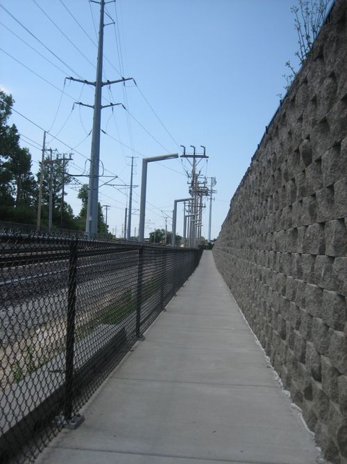
ABOVE: West exit for the Brentwood MetroLink station

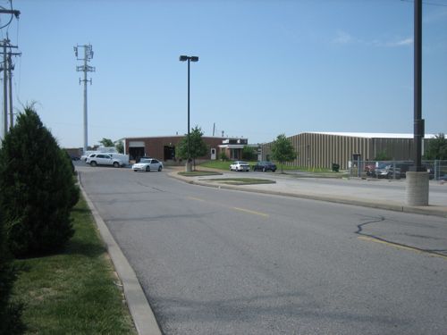
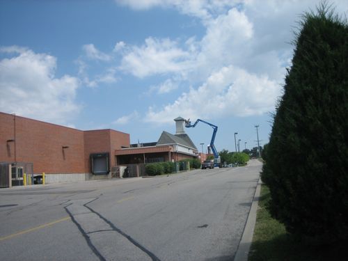
The journey starts with the narrow & long path up to grade from the west MetroLink platform. At the top you see the grim reality of what the pedestrian will find at the top.
img_0407
ABOVE: To the left is the Hanley Industrial area
img_0408
ABOVE: To the right is the back of the Dierbergs
img_0416
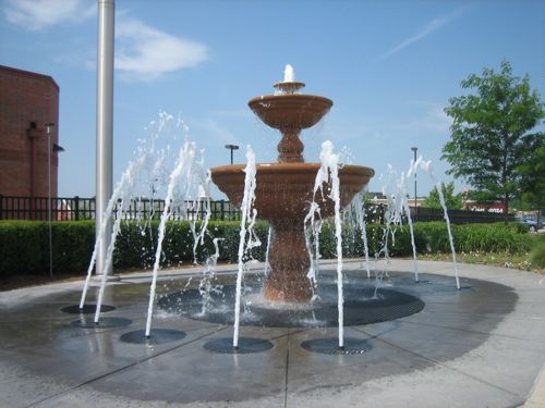
ABOVE: Decorative fountain along Eager Rd is for show to make the motorists less depressed

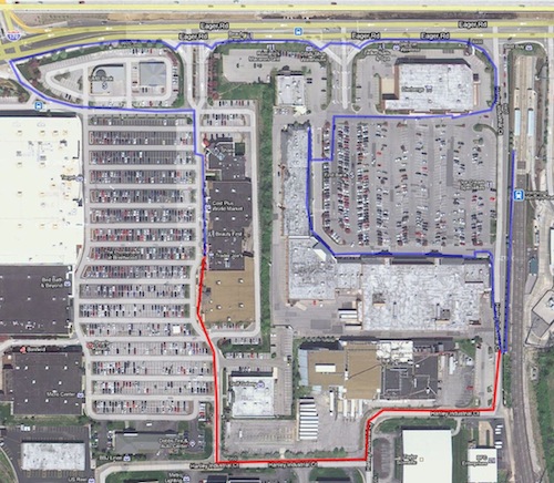
I got to to the Trader Joe’s in the next development but it was not an easy task. Below is an aerial showing the route (blue) from the MetroLink station on the right to Trader Joe’s
brentwoodmyroute
ABOVE: Route from MetroLink to Trader Joe's (blue) and back (red). Click to view in Google Maps

It was kind of a crazy route because I was trying to find a way other than just through a parking lot. You see on the day I made this trip I was still a few weeks away from driving again post-stroke.  Transit and my power chair was my only option to reach Trader Joe’s.

I felt unsafe going to/from a store that is very close to expensive transit infrastructure.  I talked to a couple of lawyers that take ADA cases.  They liked the case but they didn’t have $30,000 to bring a suit.  I feel Brentwood was primarily responsible since they acquired the land for the developments.  When built next to the rail line they knew future plans called for a station.  The fact it wasn’t built to handle pedestrians is shameful.

The fact another $664,000 tax dollars needs to be spent to improve the area is frustrating. Why wasn’t this built better to begin with? Someone at Brentwood was asleep!  And this project only gets you to the edge, “providing safe pedestrian access to the south entrance of the Brentwood Promenade.”

Once at the south entrance you still cannot safely visit each merchant. Look for lots of money to be spent in the coming decades retrofitting pedestrian access where it should have been in the first place.  I’m not saying this shouldn’t be done now, it just should have been better planned so the best pedestrian route wasn’t the back way through an industrial park.

– Steve Patterson
 

Collinsville’s Gateway Conference Center & Adjacent Doubletree Hotel

Where do you look to plan an annual conference in the St. Louis region where you will have large & small meeting rooms plus hotel space for 2,000+ attendees.  If your budget is large you go to America’s Center in downtown St. Louis.  But if your budget isn’t so big you go to the Gateway Conference Center in Collinsville IL (aerial).

“Most of Collinsville’s lodging is within walking distance of the convention center.”

That seems very convenient!

The Gateway Convention Center is located adjacent to the Doubletree Collinsville/St. Louis and is an ideal partner for your larger meetings and tradeshows. Gateway Center offers 50,000 square feet of flexible, ground-level space that is sure to suit all your event needsThe convention center is surrounded by more than 40 restaurants and several visitor-friendly attractions. Lambert St. Louis International Airport is a short 30 minute drive away.

Together with Doubletree Collinsville/St. Louis, Gateway Center is “The Great Way to Gather” in the St. Louis MO metropolitan area for large events!

Wow, perfect! Convention center with adjacent hotel and others within walking distance.  Sounds perfect, right? Well almost…

img_1562
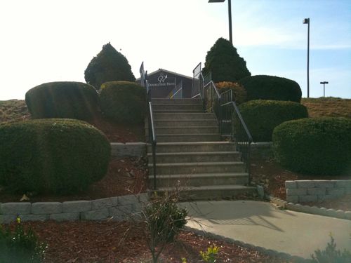
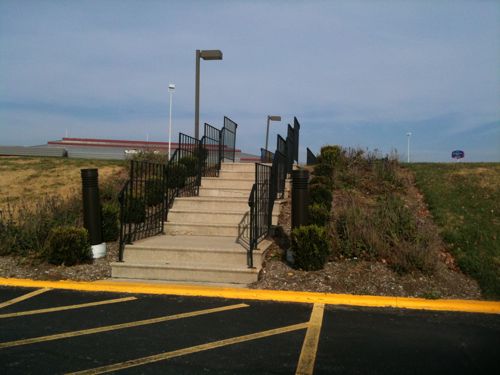
ABOVE: Stairs over drainage ditch from Doubletree to Gateway Center (see in background)

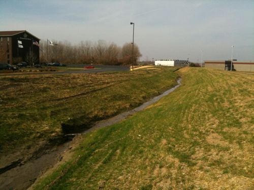
If your conference has persons with mobility issues these stairs are a major obstacle. The problem is a flood control channel owned by the U.S. Army Corps of Engineers.

img_1557
ABOVE: Flood control ditch between the Doubletree (left) and Gateway Center (right)

The Doubletree is adjacent to the Gateway Center  and it has the small meeting rooms the other hotels in the area lack but the stairs are a major barrier when 100 or so of your attendees use mobility scooters, wheelchairs or just push baby strollers.

img_1554
ABOVE: Stairs over drainage ditch from the Gateway Center to the Doubletree (see in background)

Part Two of this post will be published next week on the 29th.  That post will look at the walkability & accessibility of the Eastport Plaza area where Collinsville’s Gateway Center is located.  Pushing carts of convention materials from the main hotel to the center is also impossible.  The solution is a “switchback ramp” on each side of the levee. The Doubletree Hotel has new ownership and recently received a $12 million dollar makeover inside & out.

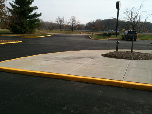
ABOVE: New concrete work around the Doubletree, but no connection to public sidewalk or ramp to Gateway Center

The hotel was built in 1982, construction on the Gateway Center started six years later. In 2007 the hotel, then a Holiday Inn, made the headlines.  This article from July 3, 2008 explains:

“The state auctioned off the hotel Thursday. St. Louis-based Lodging Hospitality Management, which owns 16 hotels in the St. Louis area, submitted the highest bid of six that were submitted, according to [Illinois State Treasurer Alexi] Giannoulias.

Giannoulias said in a statement that installing new owners will put an end to a 25-year “financial debacle.” Giannoulias said former owners B.C. Gitcho and Gary Fears received “an outrageously favorable $13.4 million state-backed loan” and quickly fell behind on payments enough that the outstanding principal and interest totaled $32.2 million.”

What I don’t yet know is when the steps and bridge were built over the flood control ditch.  Was the costs shared by the hotel and Collinsville? Did bonds for the Gateway Center finance the steps & bridge to the existing hotel?  I will keep digging.

In the meantime, next week I will post a look at the area where the Gateway Center is located, called Eastport Plaza.

– Steve Patterson


North 14th Street Demonstrates How A Pedestrian-Friendly Streetscape Should Be Designed

On September 1 2006 I reviewed the plan for replacing the North 14th Street Pedestrian Mall with North 14th Street: Old North’s Pedestrian Mall May Soon Be Gone! I concluded the post with this paragraph:

“I have some initial reservations about the streetscape plan but I will hold those back until I’ve had a chance to talk with the local residents, the RHCDA and Rosemann Architects. I want to congratulate everyone involved for finally getting a project to this point – I look forward to working with them to see it to fruition.”

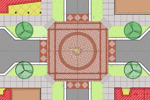
The following drawing was included in the post.

ABOVE: Concept drawing from September 2006.

Privately I shared my reservations about the pedestrian circulation.

14thmontgomery2006
ABOVE: Close-up of 14th & Montgomery on 2006 plan

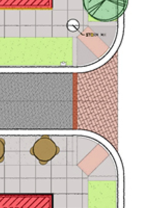
Unfortunately I can’t locate the somewhat harsh email I fired off. However my criticism focused on 1) the decorative brickwork and the fact pedestrians couldn’t maintain a straight line as they walked down the street. The green areas were to be planters.  These would have created tight points where pedestrians tried to cross the streets.  Remember, this was 17 months prior to the stroke that disabled me.

14thwarren2006
ABOVE: Close-up of 14th & Warren on 2006 plan

The planters and the ramp placement would have forced all pedestrians (able-bodied & disabled) to zig-zag at each intersection. At the time I had no idea how annoying such intersections would be from a wheelchair but I did know the concept was not pedestrian-friendly.

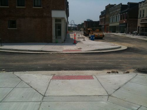
June 2010
ABOVE: During construction, June 2010

In June 2010 I was glad to see my criticisms had been observed with the design now permitting all pedestrians to maintain a straight line as they walked from one block to the next.

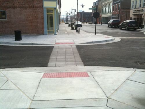
img_1488
ABOVE: The final result is very pedestrian-friendly. November 2010

I’m so glad the completed design permits the disabled in wheelchairs to use the same pathway as the able-bodied.  All have lots of room, all can stay on a direct path.  Nobody is pointed into the center of the intersection with angled ramps.  This is how pedestrian-friendly business districts should be designed.

Unfortunately many of the new streetscapes being installed in other areas  do not have the same direct path for pedestrians.

– Steve Patterson


Sidewalks Are Constantly Abused

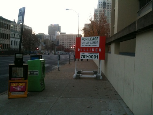
ABOVE: Sign consumes much of sidewalk along Olive between 14th & 15th

Many see the public sidewalk as wasted space where they can do as they please.  Presumably that is the case of this for lease sign I spotted early yesterday morning. Hopefully the St. Louis Streets Dept didn’t grant them a permit to place this sign on the sidewalk.  Yes, the sidewalk is still passable but such things greatly reduce the pedestrian experience.  We do need more pedestrians in the city but we need to stop giving people reasons not to walk.

– Steve Patterson


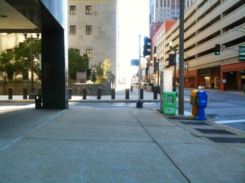
Poorly Executed Pedestrian Access Around St. Louis Federal Reserve

Yesterday I posted about the challenges crossing 4th Street at Locust (Crosswalks & Curb Ramps Needed at 4th & Locust) to get to the Federal Reserve.  Today I want to share problems with crossing Broadway (5th) at Locust and St. Charles at Broadway to reach the Federal Reserve.

a
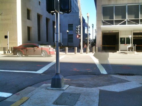
ABOVE: view looking east across Broadway on the south side of Locust

The situation, above, differs from 4th in that here a crosswalk exists on the pavement.  However, there is no curb ramp on the far side. Like 4th, this was done when the Federal Reserve took over this block of Locust for their pedestrian plaza.

From the Post-Dispatch on December 11, 2003:

A $13 MILLION PLAN to restore the Security Building took an important step forward — and so it seems did a proposed $90 million investment by the 500-pound gorilla next door, the Federal Reserve. … The designs for the Security Building, by the way, revealed another interesting transformation: a Fed plan to replace Locust Street between Fourth and Broadway with a pedestrian plaza.

So the Federal Reserve spent $90 million but they couldn’t include a couple of curb ramps in newly poured concrete?  Unacceptable!  But in November 2005 the Downtown St. Louis Partnership (now Partnership for Downtown St. Louis) gave the Federal Reserve an award for the plaza.

a
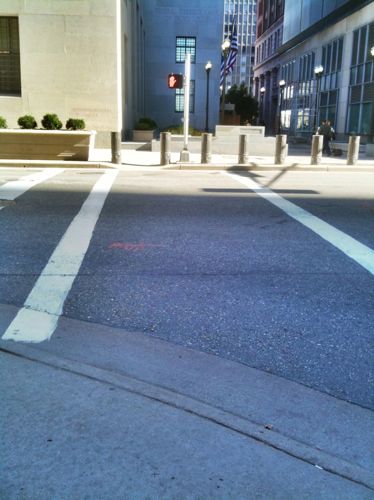
ABOVE: view looking east across Broadway on the north side of Locust

There is one spot where both ends of the crosswalk have curb ramps, shown above.  Recently the Federal Reserve completed their expansion, which included a new sidewalk along St. Charles St.

a
ABOVE: view looking east across Broadway at St. Charles

On the right you will see a curb ramp at the corner of the new work by the Federal Reserve.  Not sure where someone is supposed to go from there.  The detectable warnings direct the blind into the middle of the intersection.  I suppose someone could cross Broadway since an exit from a parking garage could serve as a dangerous curb ramp on this side of Broadway.

b
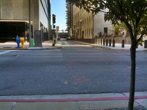
ABOVE: view looking south across St. Charles at Broadway

When trying to cross St. Charles there is a curb ramp on this side of the street, between the building corner and the traffic signal.  However, the ramp for the other side is way out at the corner, hidden from view by the blue & yellow boxes.  Brilliant!  I guess for only $90 million you can’t expect much?

Keep in mind that others, such as parents with strollers, use curb ramps.  These issues are personally frustrating to me but they make St. Louis less than ideal for all pedestrians.

– Steve Patterson


Advertisement


[custom-facebook-feed]

Archives

Categories

Advertisement


Subscribe