MVVA’s Winning Concept To Finish Destroying Riverfront Street Grid Pt2
Yesterday I looked at MVVA’s plan to close Washington Ave between the river and I-70. Today I will look at proposed changes an the edge of the Mississippi River.
“Our proposal removes the existing waterfront streetscape in order to reinstate the full form of the cobblestone levee. Sculptural river gauges mirror the monumentality of Saarinen’s river walls and frame the use of the levee surface in relation to the fluctuating river edge. The single central stage is replaced by a gentle swell in the cobble surface that can accommodate a broader spectrum of markets, concerts, and seasonal attractions.”
Consultants had this to say:
This design would improve connectivity for pedestrians and bikes at the north and south ends, but reduce vehicular connectivity overall with the closure of Washington Avenue and Poplar Street. Gates would be added to the arches under Eads Bridge, removing vehicular access to Leonor K. Sullivan Boulevard from the north. In addition, moving the garage entrance closer to the river would result in diminished access due to frequent flooding.
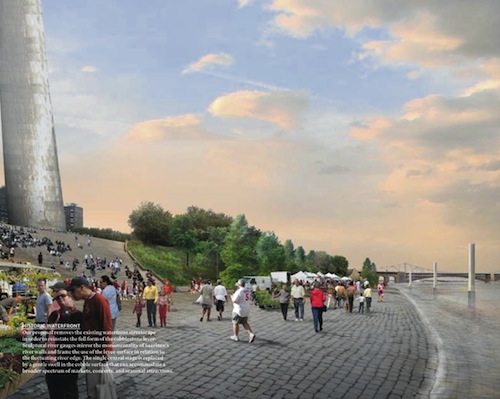
The drawing looks good but the reality will be quite different. Â Like the many failed pedestrian malls we’ve had in the US, removing cars is no guarantee pedestrians will fill the space. In fact, removing auto access makes it more difficult for some to reach the location. Â So do I think it should remain unchanged? Â Hardly. Â I’m an advocate of mixing all modes of transportation — pedestrians, bicycles, transit, and vehicles.
Like the stretch of Washington Ave next to Eads Bridge, Lenore K. Sullivan is excessively wide.
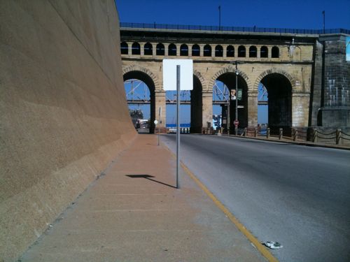
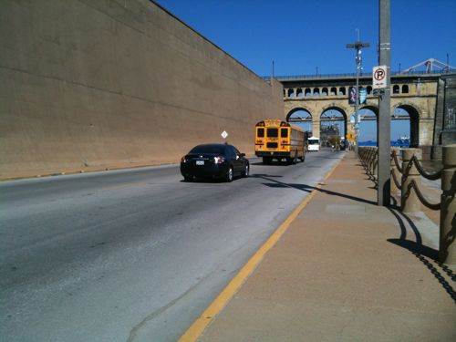
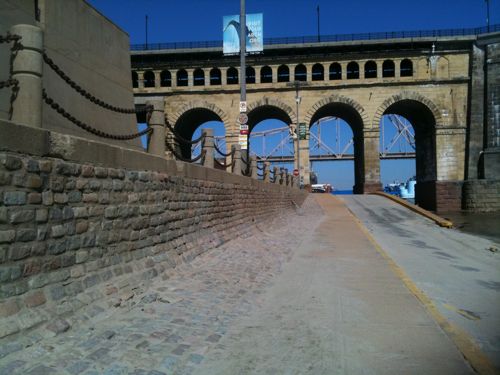
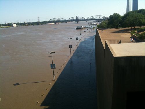
I personally would like to see a very narrow street remain, too narrow for tour buses & trucks. Â Include pockets of on-street parking on both sides but include bulb-outs between the pockets so the main curb to curb is narrow, even if no cars are parked. Â For events the street can be closed as has always been the case for years.
The stated goal of the competition was connectivity, closing off streets does the opposite.
– Steve Patterson

Couldn't agree more Steve.
Is it “too wide” or does it just seem that way since parking is prohibited? Allowing / encouraging on-street parking may actually be a better solution. But that could also look “messy” and eat into garage revenues.
I do find your selective reasoning interesting. First you say “I’m an advocate of mixing all modes of transportation — pedestrians, bicycles, transit, and vehicles”, then you say “I personally would like to see a very narrow street remain, too narrow for tour buses & trucks.” Transit buses and tour buses are both the same width. As someone who's both an urbanist and a person who lives with a disability, I'd think that you'd be the last one to want to restrict buses. But if that's really your goal, a better way would be to limit vehicle height (to 8'? 7'? 9'?) than to limit width.
Let's give the boulevard its historic name back – Wharf Street.
Parking was allowed on Sullivan last week when I was down there and the levee parking lot was flooded.
For some reason I think if this design goes through, they will be overhauling it 20-30 years later. It is bland and does not offer any real “solutions” it seems like.
I'm also intrigued / concerned with the statement that “Gates would be added to the arches under Eads Bridge”. Obviously, this is being recommended to limit access between the park and Lacledes Landing; the question is why? For better security? Or to create a limited access venue, a la Verizon Wireless Amphitheater?
Tourists zones are probably an exception to your perceived pedestrian-mall depression effect. People like to walk along rivers and near monuments. Also, what exactly is the practical use of the riverside road, exactly? Changing the highway to a boulevard would reduce to negligible any need to use the road.
To reiterate: this is not a commercial pedestrian mall. This is a park. I see no issue with removing the road and would, quite happily, see it removed.
One purpose of the road is to get supplies and tour buses to the riverboats. Yes, most are gone now, but if we ever want boats to return, having no tour bus access would be a difficult hurdle to overcome…the tour buses can make or break a riverboat.
And I love how that picture makes the cobblestones look so smooth and level. Reality is quite different.
If this contest activates development of Chouteau's Landing and, to a lesser extent, Laclede's Landing, I'd like to hope these sister districts (named after our city's founders, no less) would be connected better than the half-mile walk/bike levee path MVVA's plan proposes. I can see how heavy traffic would diminish the aesthetic, but let's be honest — how often is traffic heavy down there.
If it were me (which it isn't) I would narrow the lanes as some have said and, to encourage folks to park in the garages, render it void of both street parking. But leave it open to traffic! Let people use it to travel and insert some designated tour/school bus drop-off insets (but no idlers!).
Ultimately, I'd like to see a dedicated Wharf Street trolley line hugging the west edge of the boulevard and taking people to and from Chouteau and Laclede's Landing (for free?) with the option to lengthen it as development continues to the north and south. It wouldn't have to be expensive since it's a relatively short stretch and the trolley wouldn't have to be state-of-the art since it's an area that definitely complements that vintage, well-worn trolley idea. Also, it wouldn't run during high-water periods obviously.
Make some changes to LKS, MVVA, but allow vehicle access and DO NOT gate down the Eads.
Oh, no ghost-carring allowed either…
If Wharf Street (agree is much better than Sullivan blvd.) is cut off it will no doubt be the first time in the history of St. Louis without a river road in this area.
The huge mistake installing a mall is that there will be nothing to fed people to this area if the road is closed. Successful plazas and squares are fed by active buildings that surround them. While it is not clear how far south this will go, it is a fantasy to think throngs of people will be walking around this area as is pictured in the drawing. What are they going to do? Climb up and down 6 stories from the Arch, or walk a thousand feet visit the driftwood in the river?
By cutting this area off it also will put pressure on a future Memorial Drive to the West of the Arch, local traffic especially would be diverted, one purpose of the grid.
Nor can I understand how such a decision can be made without knowing the general direction of development south of the Arch, what ultimately happens there will help determine whether the river road should connect LaClede's Landing with the South.
Tower Grove Park relates pretty well to the surrounding neighborhoods, it is a standard the Arch grounds should meet.