Downtown Trolley Ignored By Metro, CVC, & Downtown Community Improvement District
In July 2010 the #99 downtown circulator became the #99 downtown trolley, a bus wrapped in a cartoonish look.
“We are pleased to introduce this new trolley service, which will not only benefit downtown residents and workers, but also the millions of visitors St. Louis welcomes annually,” said Kitty Ratcliffe, president of the St. Louis Convention and Visitors Commission (CVC). “Just in time for the Fourth of July holiday weekend, this new service will enable tourists to experience more of the world-class attractions, sports venues, culture, retail and dining that St. Louis offers.” (Partnership)
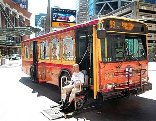
Many laughed three years ago, but based on observations during my use, I’d say it has been a resounding success. I regularly see other downtown residents, workers, & tourists on the trolley bus. It does the job Metro, The Downtown Community Improvement District, and the Convention & Visitors Commission intended.
Unfortunately, it is all too often ignored by these three entities. I’ve got two examples:
First, I overheard a Metro employee helping tourists who wanted to go from the Crowne Plaza hotel to Sweetie Pies’ Upper Crust the next day. The Crowne Plaza is located downtown at 200 N 4th St (@ Pine St) and Sweetie Pies’ Upper Crust at 3643 Delmar in Midtown/Grand Center.
The Metro employee suggested walking to the Convention Center MetroLink station to catch the train to Civic Center MetroLink station to catch the #97 (Delmar) MetroBus to Sweetie Pies. Really?
I’d have suggested catching the #99 trolley across Pine St, taking it to the City Museum stop on 16th between Delmar & Washington Ave, walking half a block to 16th & Washington Ave to catch the #97 to Sweetie Pies. Google Maps agrees, though it would make the transfer at 14th & Washington.
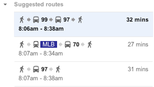
The order of suggested routes does vary based on departure or arrival times. The MetroLink option it suggests is to go to Grand and take the #70 bus north to Delmar. This may have been what the Metro employee told them to do, but I’m pretty sure I heard her suggest the Civic Center. The point is people get needlessly directed to MetroLink, having them walk more or go way out of their way. I’d never want a tourist to try to find the #97 bus after leaving the train, it is confusing to me and I know the area well.
The other example is one of omission.
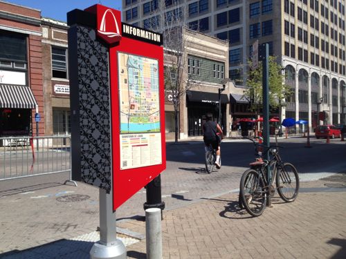
Yes, the pedestrian directories to help tourists navigate downtown doesn’t the trolley route & stops. It’s as if the trolley doesn’t exist at all.
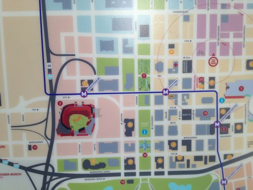
Trolley info doesn’t appear on the downtown directories! Such a huge omission, but not surprising given the anti-bus attitude of so many. The trolley route could easily be shown on the directories.
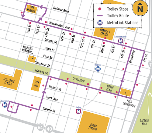
The directory listings are just printed, easily updated. I’ll be notifying all three entities (Metro, Downtown CID, CVC) about the omission. We’ll see how long it takes to get them updated.
— Steve Patterson
The CVC’s downtown pedestrian directories can show only so much information and remain legible (much like the trolley route map in the last illustration). The Trolley is, in reality, just another bus route, and no other bus routes are shown on the pedestrian directories. Most pedestrians have little interest in paying a fare to ride just a few blocks (they’d rather just walk). However, if the trolley were free, it would be a different story/argument . . . .
I disagree, the trolley is quite popular with tourists. It helps them navigate an unfamiliar city. A good graphic designer could overlay the route & stops.
I don’t question the trolley’s popularity, with either tourists or downtown residents and workers. I do disagree with trying to post one (or all) of Metro’s bus routes on maps aimed primarily at pedestrians. Metro already posts a map online showing all their downtown routes, that, as a tourist, I would find to be more useful, since it gives me all of my bus and rail options, not just one: http://www.metrostlouis.org/Libraries/System_Map_PDFs/Map_DownTown_STL_083010.pdf
The question really becomes where do you stop (on our pedestrian maps)? The map already shows a closed department store (Macy’s), along with downtown’s tourist attractions. Should it also show every hotel? Every restaurant? Or do you just make it portable, like they do in Chicago (which I prefer, since I can carry it with me, and not have to search out a map on the sidewalk to figure out my next trip): http://www.transitchicago.com/assets/1/brochures/13JN_017-DTSSG.pdf
The downtown directories are designed to help people find their way to destinations, like City Museum. It’s one of the most popular attractions downtown, yet on the map it looks very isolated. That’s why the trolley has a stop on 16th.
If you look at the map it’s very obvious the route could easily be delineated much the same way MetroLink is shown, just in a different color. It’s an important element that needs to be included.
The #99 is very different than other bus lines. It had unique branding, Metro pays a licensing fee to use the trolley graphic. Like BRT, the stops are fewer than with regular bus routes, with unique graphics and a route map. The route hasn’t changed in 3 years.
This is a poor excuse, but I wonder if they omitted the trolley because it is not as “permanent” as the Metrolink? I think that presumption would then lead to the important of streetcars and more “permanent” transit options. I am not anti-bus, because I know realistically it is all that a lot of communities can afford in order to have good coverage, but I bet they omitted it on purpose in case Metro has another cutback and has to cut the trolley away. That then leads me to state-level funding of transit, and that is something Jefferson City needs to do better, in my humble opinion.
I typically use mobile apps like HopStop or Transit+ when visiting other cities like Chicago and D.C. to plan my transit trips as I go. Sometimes I use it here as well. Or, I grab some printed schedules if they’re available. We have so few bus routes serving the core of downtown St. Louis anymore, the #99 is an important link for tourists and local visitors who may not be familiar with bus systems.
But in practice, I rarely use the #99 myself. I mostly just walk to destinations in the downtown core when I get off MetroLink. It’s just not worth waiting for the #99 at Civic Center if I’m going to Central Library or my auto mechanic at 15th and Delmar, I can probably walk there faster via 14th Street. Sadly, most of the MetroLink stations in downtown just aren’t that busy in my experience, even at rush hour. Just yesterday I walked from a meeting at Olive and Beaumont to the Union Station MetroLink. Even at 5:15 pm, there were only a handful of passengers on and off at that station.
By contrast, my daily commute from Shrewsbury to Central West End stations is packed with commuters (mostly subsidized by my employer, I realize). I love downtown, I just wish there was more going on there on non-event days.
Well, depending on the outcome of Metro’s BRT proposals, the #99 may not exist much longer. Both the I-64 and Page proposals duplicate the #99 route in full.
Any BRT route should be shown, in the meantime the trolley needs to be added.