May 26, 1954: South Broadway Drive-In Theater Opened
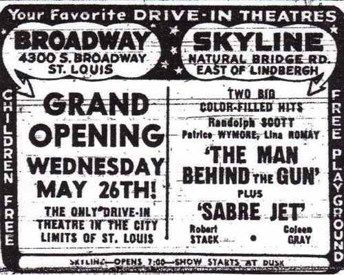
The Wednesday before the Memorial Day weekend in 1954 was the grand opening of a new drive-in movie theater in St. Louis, at 4300 South Broadway. As you can see below, it was billed as “the only drive-in theater in the city limits of St. Louis.”


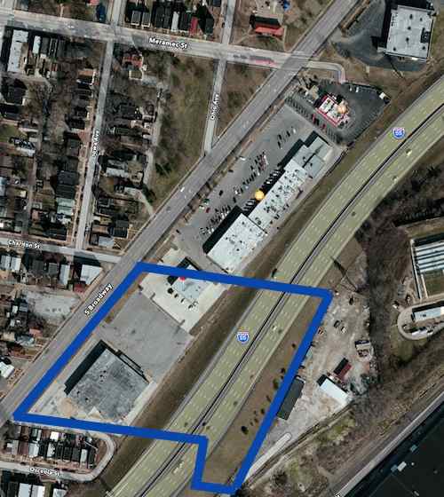
I began to wonder what was on this site before the 1954 theater. Sanborn Maps from October 1908 show H.H. Schweer Brick Company located east of Broadway and south of Chariton (See here & here), Brick by Chance and Fortune filmmaker Bill Streeter hadn’t heard of this company. The first linked Sanborn Map shows the St. Louis Workhouse across Chariton St from the theater. In 1908 a bowling/dance hall was north of Meramec (view map). In 1908 & 1958 Chariton & Meramec streets continued east of Broadway, these were likely closed after the highway was started in 1962. Interstate 55 had a big impact on this area.


In the coming weeks I’ll take a look at the commercial development along this stretch of Broadway and share my concept for an urban redevelopment. Have a great Memorial Day!
— Steve Patterson
Great info – thanks! If anything, it’s an interesting commentary on how entertainment is distributed and enjoyed falls in and out of fashion. Drive-in theaters needed cars, but didn’t need air conditioning, TV or the internet.
I have lots of unanswered questions, such as: was the drive-in still thriving when the highway was built? My guess is yes.
The site http://www.drive-ins.com/museum/timeline.htm says the peak was 1958, that some began closing in the 70s.
Since you are venturing into the discussing the future of the S. Broadway area, it will be interesting to ponder what may come and how to get there. Ideas abound, but markets drive investment. The area is part of at least two wards, 9 and 20. It’s a long stretch, essentially running from the mostly vacant/vastly underutilized Lemp Brewery to where Broadway passes under I-55.
It’s got a good public high school. It’s got the historic Charless Home (now closed). It’s got a decent city park. It’s got low market value housing. It’s got decent population density and relatively low crime. It’s got bus service. It’s at the southern extension of a future Jefferson Avenue alignment to Metrolink.
In times of heavy automobile traffic, it’s a good alternative to I-55. The area is close to downtown and largely “historic” in terms of its building stock. It’s got a good local community development corporation in Dutchtown South Community Corporation. Area alderman including Ken Ortmann, Craig Schmid, and Shane Cohn are energetic, passionate, and bright.
It’s outside the “Central Corridor”, so it has a hard time getting much civic backing. It, like so much of St. Louis, needs a long term, funded, “neighborhood strategy”. When that gets articulated *and led*, we’ll see good things. Until, then, ideas will abound, but words don’t mean much.
I agree and disagree with your points. I’ll start with “markets drive investment.” Yes and no. What is the market? The market isn’t fixed, it’s fluid and constantly changing.
The planned park & ride lot for suburbanites to catch light rail into downtown would create one market. However, a series of mixed-use multi-story buildings at the end of a light rail line would appeal to an entirely different market segment.
Well, yes, it’s true: markets are constantly changing. But most would agree this area is not fit for high dollar, Chesterfield, “McMansions”. It’s low-middle class, mostly. Incomes are generally lower than the area median. But the real trick is, and this questions goes out to urbanists and preservationists everywhere, how do you get a neighborhood agenda going in St. Louis? Northside Regeneration is not a neighborhood agenda. Dutchtown is a neighborhood. O’Fallon is a neighborhood. What’s the strategy to preserve these areas, which comprise most of St. Louis?
Most of St. Louis County and the 16-county region isn’t ” fit for high dollar, Chesterfield, “McMansions”” Being an area that’s lower on the economic ladder means there’s a natural mark for good affordable housing, possibly apartments over retail.
Remember that just a half mile south on Broadway there are very expensive homes overlooking the river. To the west you have an influx of creative young people who’ve been priced out of neighborhoods closer to downtown.
And as I’ve said in numerous posts, the answer is looking at a corridor, not the neighborhood.
Well, let’s say we agree the corridor is key. And to lubricate the effort, installing a Metrolink/light rail extension. So how do we ever get that done?
The light rail as conceived isn’t about strong urban neighborhoods, it is a way to give suburban commuters a massive parking lot to park in and a fast way to the CBD & events.
See the Shrewsbury MetroLink station from 2006. Any new housing or commercial development as a result of the big parking lot? Nope!
So the first thing to do is to reject the park & ride lot on south Broadway. I like the route but I’d do a similar streetcar line instead of light rail. It would have more stops so more potential for development.
You keep saying, “I’d do” this, or “I’d do” that. The trick is to convince the “we” do to something. Are you suggesting that the “we” wants a commuter park and ride lot?
The north-south study completed 7-8 years ago assumed park & ride lots for suburban commuters to use. The north line would end at a big parking lot on Goodfellow.
You’re not answering the basic question of how to go from “I’d do” (whatever) to getting to let’s “we” do something together. Ideas ain’t actionable without popular support and funding to make them happen.
A new streetcar line is NOT the answer for new development. If it were, St. Charles County would have miles of streetcar lines instead miles of strip shopping centers, franchised drive-thru’s and multiple sudivisions full of cul de sacs.
The problems & appropriate solutions for an older inner city area aren’t the sane as an edge suburban county, uniformily thinking they should be the same is incorrect.
Nice Freudian slip – I agree, the solutions aren’t the sane. But the core problem in old, urban St. Louis is not transit – we have pretty good bus service in the core city – the problem, as guest articulates, is that it costs money to do good urban infill and the market demand simply is not there. We looked at the newest development offering “very expensive homes overlooking the river”. They’re the same plans that they’re building in St. Charles County, only they’re charging a $100,000 lot premium for the view ($240K vs $140K base prices). Why? Because that’s where they think the market is and because the $400K units in the first phase weren’t selling! Lose the view and you lose the market, which they’ve essentially conceded, since there appear to be no plans except for “common area” on the land between Broadway and the one row of homes that will have a view. If there were a viable market for more affordable, new housing, I’d expect that land being put to that use, not just left vacant.
The planned light rail line would use vehicles very similar to a modern streetcar line, except the LR line would limit places where cars/pedestrians could cross Jefferson.
Are we confusing two corridors/issues? The LPA would appear to have minimal impact on Broadway. From wikipedia: “SouthSide Corridor – Downtown to Bayless to Butler Hill – The 9-or-17-mile (14 or 27 km) extension starts from Downtown to the south of St. Louis County to Bayless I-55. A study for this extension was completed in 2008 and a Locally Preferred Alternative selected. The Locally Preferred Alternative begins at the Multi-Modal Transit Center at 14th & Spruce Sts., continues south on 14th St. to Chouteau Ave., travelling west on Chouteau to Jefferson Ave., then travelling south on Jefferson to Meramec St., where it then follows a right-of-way on Interstate Highway 55 to a terminus at Bayless Ave.”
Jefferson & Broadway merge south of Chippewa. The planned light rail would be a divider on Jefferson/Broadway until it reaches I-55. Phase 1 would be a park & ride at this site. Going from the street to be adjacent to the highway would require the taking of private property, and unfriendly concrete flyovers. The light rail plan would be awful for south St. Louis.
I agree, running light rail down city streets does little or nothing to help the adjacent residents and “would be awful for south St. Louis”. That said, the distance from Jefferson/Broadway/Chippewa to Gasconade or Meramec is just 3 or 4 blocks, respectively, and the “taking of private property” would likely be a negotiated purchase of this shopping center, not condemnation.
There are two very different, but related, issues on the table, here. We have an 8-10 mile long corridor that needs revitalization and we have a proposed “9-or-17-mile” light rail line along a different corridor. The intersection of the two is less than a half mile long, and while the opportunity for TOD creates a third issue, arguing the merits of light rail versus streetcars distracts from and confuses the larger issue of “South Broadway”.
I’ve lived in St. Louis a lot longer than you, I know I have to speak against light rail now. If I wait officials will say it’s too late to change the plans. If we want to invest in rail-based public transit in the city streets it should be streetcars, not light rail.
Private property would be needed all along the light rail corridor north & south. A streetcar line wouldn’t take up as much right-of-way.
Jefferson needs revitalization too, just like Broadway. The issues presented by light rail on Broadway south of Chippewa would be the same all the way north to Chouteau.
I agree with you, light rail is a poor vehicle / technology choice for the Southside Connector – I made that pretty clear when they were doing the study. My point may be simply my own confusion – I thought the point of this post was development opportunities on the South Broadway corridor, not development opportunities on the Jefferson corridor.
This post was about an interesting bit of history, how the area went from a brick company to a drive-in theater to a highway and shopping area. At the end I mentioned I had ideas about future redevelopment, no mention of light rail.
A commenter brought up light rail that’ll run on Jefferson/Broadway.
But since you’ve opened the door to the merits of the Southside Connector, I’ll throw out several observations. One, it can’t be both a good way to move commuters between the suburbs and the CBD AND be an enhanced local transit system (as most streetcar systems function). Two, putting end-of-line park-and-rides in inner ring suburbs (or the outer reaches of the city) does little to attract commuters out of their cars. Shrewsbury is a stupid place to end the Blue Line, Bayless will be a stupid place, and this location would make even less sense. If a line is ever built out south, it needs to go at least as far as I-270 / South County Mall area, and ideally should go as far as Arnold. The same goes for the Blue Line – it should be extended either out to the old Chrysler plant site or to 141. And three, light rail works best with fewer stations, to provide faster long-distance travel. I get it, everyone wants a “convenient” station, but stations like Sunnen, that see dozens of boardings, not hundreds, every day, are more of a disincentive to use public transit than an incentive.
You know how I feel about most streetcar proposals – they’re just fancy replacements for existing buses – but I can see where they might have potential along either Jefferson or Broadway, or both. The corridors are wide enough to easily accommodate the tracks and the existing zoning and building stock are dense enough to help support transit. But for them to be successful, they need to rely on local ridership, and not assume that they will attracting a lot of riders from outside of their respective corridors. Commuters from south county are no more likely to get off at Bayless or Gasconade and get on a streetcar than they are to get off and get on a bus! Similarly, to attract commuters to light rail (or express buses), end-of-line park-and-ride lots need to be conveniently located next to freeway interchanges, not buried in a TOD. TOD is a great concept for all other stations, but end-of-line stations need to be SOV-friendly. They (should) generate both more private vehicle and more bus trips, since they should act as funnels for much larger catchment areas.
We’re in agreement for the most part. The assumption made by East-West Gateway was to get suburban commuters through the city to the CBD as fast as possible, likely because of how funding is awarded.
Going to Arnold (Jefferson County) would be a stretch for light rail, you’re talking heavy commuter rail now. Either way, this goal is a good example where an existing rail corridor is better than cutting through the urban street grid.
Doesn’t South Broadway extend all the way to the River Des Peres, through Carondelet?
Yes, it does, continuing into South St. Louis County.
Steve –
The grocery store was a National in the 1980’s – I am pretty sure it started off life as a National and then became a Big Lots when National pulled out of St Louis in 1994 – They had an in house restaurant called Ziggy’s that my Dad liked
Thanks, so it was probably built as a Kroger: http://en.wikipedia.org/wiki/National_Supermarkets
Rob: You’re close. It was a Schnucks with a “Station Restaurant”.