Cincinnati’s Modern Streetcar

Last month I visited Cleveland to check out the best Bus Rapid Transit (BRT) route in the country, see Cleveland’s Healthline Bus Rapid Transit (BRT), Part 4. Earlier this month I was back in Ohio, this time in Cincinnati.

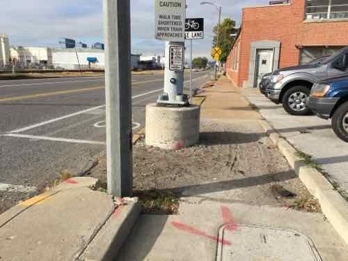
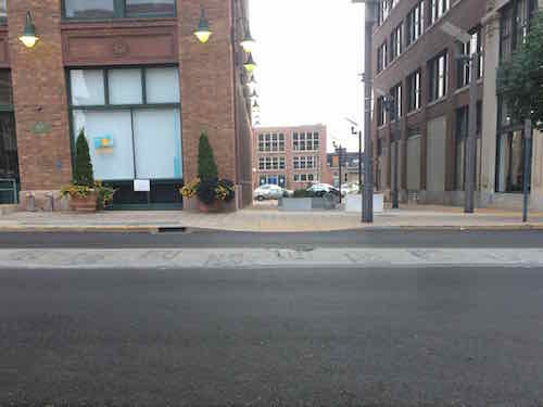
During my 3-day visit for a Streetsblog meeting we checked out the upcoming Cincinnati Streetcar. Expected to be operational by the end of September 2016, the tracks, overhead wires, & platforms are all in place.

My first sighting of their streetcar project was the tracks near The Banks (development between stadiums) turning to cross the highway and enter the central business district.
My first sighting of their streetcar project was the tracks near The Banks (development between stadiums) turning to cross the highway and enter the central business district. Second St to Main St
The platform here is little more than the sidewalk.
Most platforms are higher than the adjacent sidewalk, but very close
The platforms, built within the parking lane, are higher than the sidewalk to allow for level boarding.
Same platform from the other direction. This platform had ramps at both ends, some only have one ramp.
Warning signs are up to alert cyclists to the danger of the tracks.
A colorful welcome at one platform
Looking east
Looking east
The overhead wires are visible in this view, looking East along Central Parkway from Race St
Looking West on Central Parkway from Walnut, the streetcar track cut into the median to make the turn into the near land on Walnut. At numerous intersections cameras are able to detect the streetcar, causing the traffic signals to go into a special mode to stop all traffic -- in this case allowing the streetcar to turn right across several lanes of traffic.
Looking West on Central Parkway from Walnut, the streetcar track cut into the median to make the turn into the near land on Walnut. At numerous intersections cameras are able to detect the streetcar, causing the traffic signals to go into a special mode to stop all traffic — in this case allowing the streetcar to turn right across several lanes of traffic.
On Walnut the streetcar turns into the right travel lane
This platform on Elm @ Elder is next to Findlay public market, 1.5 miles from The Banks. The streetcar will connect these points and everything in between.
The far end of the initial line is Henry St., now closed to cars because streetcars will enter/exit maintenance yard to the left. This is at the edge of Cincinnati's Brewery District
The far end of the initial line is Henry St., now closed to cars because streetcars will enter/exit maintenance yard to the left. This is at the edge of Cincinnati’s Brewery District
The maintenance facility is a new structure.
End of the maintenance building as seen from the yard,
End of the maintenance building as seen from the yard
They've received their first of five vehicles, #1175. Their last streetcars ended in #1174. Each costs $2.9 million
They’ve received their first of five vehicles, #1175. Their last streetcars ended in #1174. Each costs $2.9 million

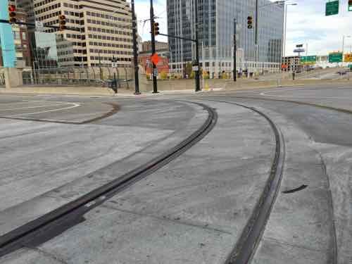
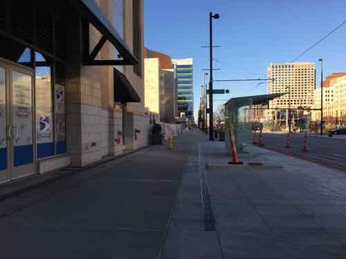
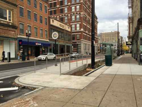
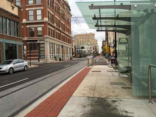
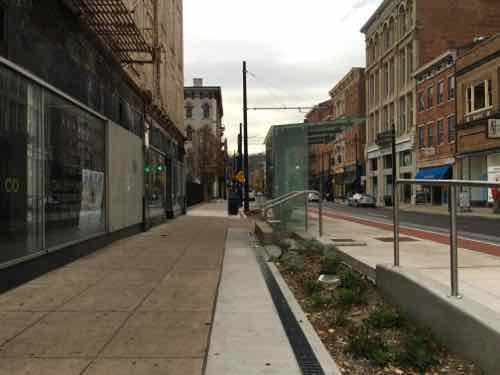
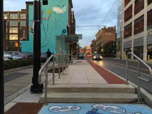
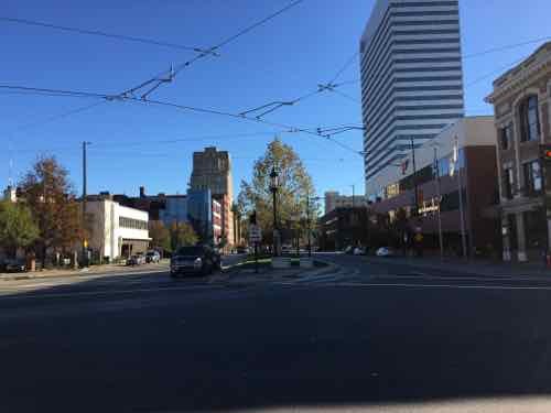
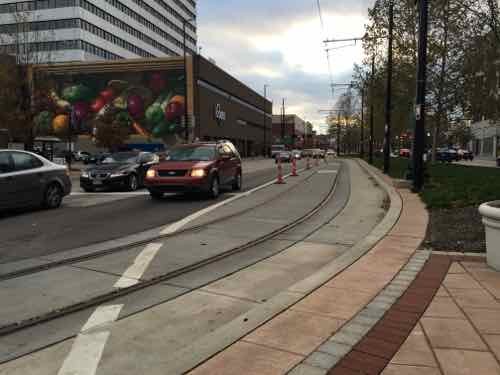
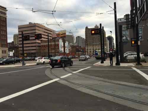
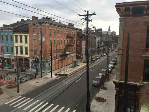
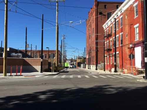
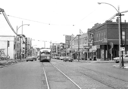
Their streetcar will run north-south on their grid of streets. Where we’ve butchered our grid, theirs remains largely intact, albeit mostly one-way couplets. I traveled over a mile on each of four parallel streets: Elm, Race, Vine, & Walnut. Their rights-of-way are also much narrower than ours are now — they didn’t have someone like our Harland Bartholomew aggressively widening streets by forcibly taking the front bay of buildings.

What we call a trolley or streetcar, Europeans call a tram.  Same thing, different name.

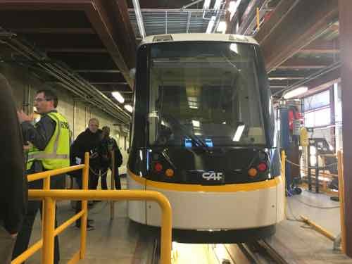
The vehicles are CAF Urbos 3, which are 100% low floor. If Cincinnati decides to do a light rail line out to the suburbs in the future they can use the same vehicles. Yes, modern streetcars use the same vehicles as light rail. The difference comes in how the route is designed. Kansas City is using the same vehicle for their streetcar line, which will also open next Fall.

If we do street-running light rail, or a streetcar, these would be in consideration. To meet requirements for federal projects, they have at least 60% US content.

Like most cities, Cincinnati had streetcars in the 19th century, a subway was started but abandoned. Cincinnati hasn’t had rail transit in decades. See their official stteetcar page here.

— Steve Patterson


Sunday Poll: Should The Number of Syrian Refugees Coming to St. Louis Be Changed?

Please vote below
Please vote below

In September we learned St. Louis would welcome refugees from the Syrian civil war.  Last week governors in numerous states changed their minds about accepting these refugees.

Which brings us to today’s poll question:

The poll is open until 8pm, the answers are presented in random order.

— Steve Patterson


Wellston Loop Family Reunion & Exhibit Saturday November 21, 2015

November 20, 2015 Events/Meetings, Featured, MLK Jr. Drive, North City Comments Off on Wellston Loop Family Reunion & Exhibit Saturday November 21, 2015

An event ia taking place tomorrow afternoon in a once-thriving commercial district: The Wellston Loop.

“Wellston Loop Family Reunion & Exhibit” will take place on Saturday, November 21 from 1 to 3pm. A sidewalk exhibition of recent photographs and historic documents will highlight the community. The event will offer free food, drink, music and videos. The primary venue will be the former J.C. Penney Department Store (on the National Register of Historic Places) at 5930 Dr. Martin Luther King Drive, St. Louis, Missouri 63112.

We’re inviting members of the surrounding community (past or present) who would like to share stories, photographs or videos of the neighborhood (Wellston Loop, Hamilton Heights and Wells/Goodfellow) from any era to submit them for inclusion and display.

Another significant building in the former shopping district is the Wellston streetcar transfer station from 1909. It is also on the National Register of Historic Places. This building has recently been awarded funding for a complete historic restoration scheduled to begin December 2015. It is the only building of its kind (streetcar station building) left standing in St. Louis.

See the Facebook event Wellston Loop Family Reunion & Exhibit for more detail.

July 1963 image of The Wellston Loop from page 59 of the district nomination to the National Register, click to view
Just inside the city limits is the old Wellston Loop streetcar building, 2013 image
The main location Saturday will be In front of the former JC Penny store at 5930 Dr. Martin Luther King Drive, click for map
The main location Saturday will be In front of the former JC Penny store at 5930 Dr. Martin Luther King Drive, click image for map. 2013 photo

For further reading. see Reflections: In Wellston, a ‘family reunion’ explores faded riches, realities – and possibilities.

— Steve Patterson


Macklind Ave Is An Inaccesible, Incomplete Street

At the start of this month I had an appointment with an orthopedic specialist, to get a cast made for a new ankle-foot orthosis (AFO).  Orthotic & Prosthetic Design is located at 5467 Highland Park Drive, off of Macklind Ave. between Manchester & Oakland. I’d been there before, usually driving. Once via the #59 MetroBus on Oakland — which goes as far East as the Central West End. With my husband at work with our car, I decided to take the #32 MetroBus — no transfer needed. I boarded at 14th & Washington.

This is the Eastbound #32 I took, the Macklind bus stop is just West of the intersection. I snapped this photo at 9:21am on November 2, 2015.
This is the Eastbound #32 I took, the Macklind bus stop is just West of the intersection. I snapped this photo at 9:21am on November 2, 2015. Click image to map bus stop.
The lowered section here is to be able to cross Manchester, but it's filled with debris.
The lowered section here is to be able to cross Manchester, but it’s filled with debris.
I wanted to locate the bus stop for my return trip, it's East of Macklind. The concrete pad isn't accessible -- no sidewalk to reach it. I'm forced to take a different MetroBus and transfer at the CWE or travel further East or West on Manchester until I find an accessible stop.
I wanted to locate the bus stop for my return trip, it’s East of Macklind. The concrete pad isn’t accessible — no sidewalk to reach it. I’m forced to take a different MetroBus and transfer at the CWE or travel further East or West on Manchester until I find an accessible stop. Click image to view closer view on Google Street View.
I rotated back toward Macklind to show you how far away from the intersection I was.
To head North on Macklind I can't go up the East side. The sidewalk is missing behind the corner but just out of view is a curb. My only option is the West side, which is ok because my destination is to the West.
To head North on Macklind I can’t go up the East side. The sidewalk is missing behind the corner but just out of view is a curb. My only option is the West side, which is ok because my destination is to the West.
At 9:26am I get to 1249 Macklind, owned by American Pulverizer, and see there's no sidewalk. Rather than risk getting hit in the street, I risk tipping over on uneven ground. If it had rained I might have gotten stuck.
At 9:26am I get to 1249 Macklind, owned by American Pulverizer, and see there’s no sidewalk. Rather than risk getting hit in the street, I risk tipping over on uneven ground. If it had rained I might have gotten stuck.
In front of the Humane Society I reach Wise Ave -- no curb cut on either side. I decide to go West on Wide to cross over to the other side at a driveway.
In front of the Humane Society I reach Wise Ave — no curb cut on either side. I decide to go West on Wide to cross over to the other side at a driveway.
On the North side of Wise Ave I managed to slowly get past the parking meters next to the Pasta House headquarters, but then...
On the North side of Wise Ave I managed to slowly get past the parking meters next to the Pasta House headquarters, but then…
I couldn't get past a light pole because the slope of the grass. I had to stand to get my chair reversed, all while not falling or sending my chair over the curb into the street.
I couldn’t get past a light pole because the slope of the grass. I had to stand to get my chair reversed, all while not falling or sending my chair over the curb into the street.
So I returned to the driveway off Wise and rode back toward Macklind in the street. But I can't get onto the sidewalk. I had to choice but to use Macklind Ave -- going into a drive and to go around parked cars until I reached a curb ramp or driveway.
So I returned to the driveway off Wise and rode back toward Macklind in the street. But I can’t get onto the sidewalk. I had to choice but to use Macklind Ave — going into a drive and to go around parked cars until I reached a curb ramp or driveway.
The next point was the street I needed, Highland Park Drive. No curb ramps here either, but I was able to get over this curb. Others might not be able to.
My destination is at the end of the street, but CBRE decided their sign was more important than pedestrians, I went around but the slope & condition of the asphalt was another challenge in a difficult morning, I arrived right on time at 9:40am.
After my appointment I headed North to Oakland Ave, at St. Louis Community College I encountered another curb. I used a nearby drive to once again go onto Macklind Ave to get around the lack of a curb cut. Whoever painted it yellow probably didn't think about wheelchair access.
After my appointment I headed North to Oakland Ave, at St. Louis Community College I encountered another curb. I used a nearby drive to once again go onto Macklind Ave to get around the lack of a curb cut. Whoever painted it yellow probably didn’t think about wheelchair access.

I did reach the bus stop on Oakland — in front of Paraquad.

When the Humane Society of Missouri opened their new headquarters nearly 18 years ago it seems nobody worried about pedestrians reaching the property — no sidewalk to the South and no curb cut to the North. Not sure how long the Pasta House Company has been in their location. And what if my destination had been on the East side of Macklind?

This morning I’ll email a link to this post to various people with the City of St, Louis, Metro, the Humane Society, American Pulverizer, the Pasta House Company, St. Louis Community College, Paraquad, and 24th Ward Alderman Scott Ogilvie. Hopefully they can collectively figure out a plan to make this area comply with the American’s with Disabilities Act of 1990. Twenty-five years is long enough, this shouldn’t still be like this.

— Steve Patterson


Readers Say Keep Washington Ave’s Zipper Motif, No Consensus How

Over half of those who voted in the non-scientific Sunday Poll favor retaining the cobblestone zipper design motif in the center of Washington Ave:

Q: Wash Ave’s 12+ year old streetscape includes a cobblestone “zipper” motif down the center, which makes repaving from 14th-18th Streets a challenge. We shou[ld]:

  1. Lose the zipper motif, not important to the well-being of the area 18 [32.14%]
  2. Retain zipper, just don’t resurface the center where cobblestones are located 17 [30.36%]
  3. Retain zipper, incurring extra costs to resurface street 15 [26.79%]
  4. Unsure/No Opinion 5 [8.93%]
  5. Other: 1 [1.79%] “Let the residents decide and let them pay for any extra costs.”

As you can see from the numbers, there isn’t a consensus view.

A recent resurfacing left the center with the cobblestone zipper intact between 14th-18th Streets.

You can count me among those who say rip out the zipper from 14th-18th Streets. The two blocks from Tucker to 14th is different — Washington Ave is brick pavers, not asphalt.

It won’t be long until the new asphalt fades and it’ll be hard to see the difference between the old & new. Setting cobblestones in asphalt was a very poor decision, and as a motif I doubt anyone could guess what it’s supposed to be.

— Steve Patterson


Advertisement


[custom-facebook-feed]

Archives

Categories

Advertisement


Subscribe