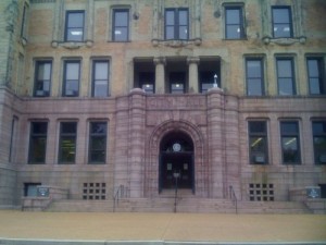
Historical Background on St. Louis’ Main Post Office

Last month I posted about how the employee line for the main Post Office parking garage was two blocks long — costing workers time & money — and polluting. My point was to find a way to reduce/eliminate this shift-change queue. However, a few comments were classic strawman fallacy — saying I wanted this post office to close — moving the sorting & processing jobs to a suburban. Uh…no. Again, my point was to collectively find a way to get people to their jobs without having to queue up just to park. That said, the USPS might decide to move mail process out of downtown to more modern facilities. If they do — it won’t be because I don’t like the daily queue for the parking garage.

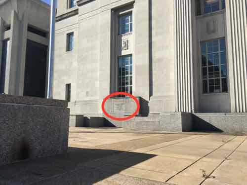
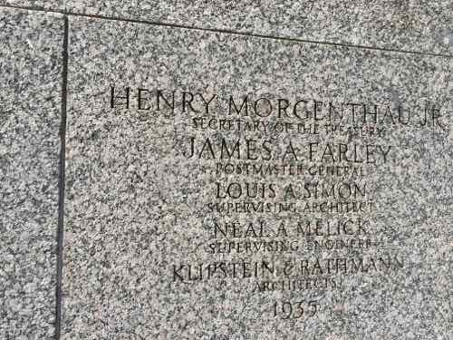
The possibility of the processing moving got me thinking about the history of the Main Post Office on this site. I knew online city records didn’t have the year built, so I’d need to investigate beyond a quick online search. Buildings from this era usually had cornerstones — people weren’t embarrassed to have their names displayed on them for eternity. Though I’d never seen a cornerstone here before, I knew one had to exist.

I spotted it, but couldn't get closer in my wheelchair. I returned home to get my cane.
I spotted it, but couldn’t get closer in my wheelchair. I returned home to get my cane.
1935 and architects of Klipstein & Rathmann should be sufficient to find out more

Back home I found online that an article from October 1935 talks about the design. So off to the 3rd floor genealogy department at the Central Library to find it on microfilm.  Note: searching Post-Dispatch articles 1874-1922 can be done online through a free database, using your library card account for access.

On October 20, 1935 the design was shown in the Post-Dispatch. From the caption: "The present Main Post Office, Eighteenth and Walnut streets, will be wrecked to make way for part of the new structure when it has progressed sufficiently to accommodate postal offices."
On October 20, 1935 the design was shown in the Post-Dispatch. From the caption: “The present Main Post Office, Eighteenth and Walnut streets, will be wrecked to make way for part of the new structure when it has progressed sufficiently to accommodate postal offices.”

So we know the Main Post Office in October 1935 was at 18th & Walnut, from the article:

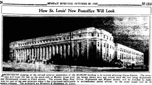
The excavation and foundation work have been completed for some time. It is estimated that it will take 900 calendar days, approximately two and a half years, to complete the superstructure. The architects are Klipstein & Rathmann of St. Louis, Engineers are W. J. Knight & Co, on structure. John D. Falvey on mechanical work and Joseph A. Osborn on electrical work. 

An earlier post office, at 18th & Walnut, was razed to build the present one between 17th-18th.  An older post office annex building still exists between the Union Station train shred and 18th Street.

Foundations done for some time? An earlier paragraph explains the delay:

Construction of the superstructure was delayed by the Supreme Court decision on the NRA which necessitated asking for new bids. Representative John J. Cochran of St. Louis has been in constant communication with the procurement division of the Treasury and with the Post Office Department in an effort to speed up the project. 

NRA? A different one.

National Recovery Administration (NRA), U.S. government agency established by President Franklin D. Roosevelt to stimulate business recovery through fair-practice codes during the Great Depression. The NRA was an essential element in the National Industrial Recovery Act (June 1933), which authorized the president to institute industry-wide codes intended to eliminate unfair trade practices, reduce unemployment, establish minimum wages and maximum hours, and guarantee the right of labour to bargain collectively.

The agency ultimately established 557 basic codes and 208 supplementary codes that affected about 22 million workers. Companies that subscribed to the NRA codes were allowed to display a Blue Eagle emblem, symbolic of cooperation with the NRA. Although the codes were hastily drawn and overly complicated and reflected the interests of big business at the expense of the consumer and small businessman, they nevertheless did improve labour conditions in some industries and also aided the unionization movement. The NRA ended when it was invalidated by the Supreme Court in 1935, but many of its provisions were included in subsequent legislation. (Encyclopedia Britannica)

The National Recovery Administration was created in 1933, but ended on May 27, 1935 when the Supreme Court unanimously interpreted the Commerce Clause differently than Roosevelt in A.L.A. Schechter Poultry Corp. v. United States.

One more quote from the article:

Besides serving the postal needs of St. Louis, the new building will be a distributing center for all postal supplies, machinery ns equipment for post offices throughout the Southwest. 

The new post office opened in 1937. so that takes care of the history, right? Not quite.  From the 1935 photo caption we know the previous Main Post Office was at 18th & Walnut, but because the current post office Walnut Street doesn’t exist between 16th-18th.  So I turned to Sanborn Fire Insurance maps:

The Sanborn Fire Insurance Map Company, established in 1867, compiled and published maps of U.S. cities and towns for the fire insurance industry to assess the risk of insuring a particular property. The maps are large scale plans of a city or town drawn at a scale of 50 feet to an inch, offering detailed information on the use made of commercial and industrial buildings, their size, shape and construction material. Some residential areas are also mapped. The maps show location of water mains, fire alarms and fire hydrants. They are color-coded to identify the structure (adobe, frame, brick, stone, iron) of each building. 
Between 1955 and 1978, the Library of Congress withdrew duplicate sheets and atlases from their collection and offered them to selected libraries. Maps for Missouri towns and cities were given to the MU Libraries. Documenting the layout of 390 Missouri cities from 1883 to 1951, the University of Missouri-Columbia Ellis Library Special Collections Department has digitized 6,798 of the maps for Missouri cities from 1880 to 1922.

This Project is supported by the Institute of Museum and Library Services under the provisions of the Library Services and Technology Act as Administered by the Missouri State Library, a division of the Office of the Secretary of State.

Most of the ones for St. Louis are from 1907-1911.

This December 1908 view has Market on the North (top), 16th on the East (right), Clark on the South (bottom), and 18th on the West (left). I'd long assumed that Walnut existed between 16th-18th, but in 1909 it didn't exist between 16th-17th. A street called Moore runs parallel to 17th. Click image to view larger version.
This December 1908 view has Market on the North (top), 16th on the East (right), Clark on the South (bottom), and 18th on the West (left). I’d long assumed that Walnut existed between 16th-18th, but in 1909 it didn’t exist between 16th-17th. A street called Moore runs parallel to 17th. Click image to view larger version.
Trying to find the previous post office I zoomed in on 18th & Walnut

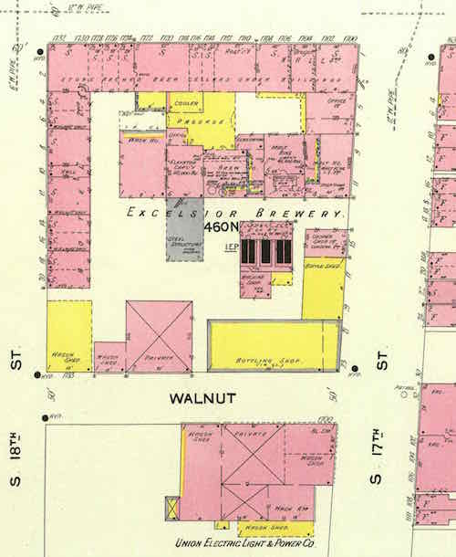
In the block bounded by Market, 17th, Walnut, and 18th is Excelsior Brewery. The only thing South of Walnut is a Union Electric building with vacant land. My unconfirmed assumption was a post office was built after December 1908 o the block South of Walnut. So the new post office replaced the brewery? That was my initial hunch, but it’s far more complicated.

An article from October 21, 1917 has the headline: “$1,000,000 HOTEL PLANNED TO FACE UNION STATION”. The “skyscraper type” hotel would have 450-500 rooms, to be built by someone from Oklahoma.  From that article:

The site, which is owned by the St, Louis Brewing Association, will be acquired either under a 99-year lease or by purchase outright. Norman Jones, secretary and treasurer of the brewing association, stated the owners are not interested in the project, but are desirous of leasing the site for improvement with a building of the nature stated. He said the association would either lease or sell the plot, and for that reason it had declined to tie it up with short-term leases. He stated that the association had plans, several years ago, for a large hotel for this plot, but that they had been lost. 

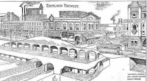
The Market street frontage is filled with a conglomeration of small stores, picture theaters and saloons. The rear, or Walnut street side of the block, was occupied by the Excelsior Brewery, the building of which was recently razed. 

Several years ago a group of Chicago capitalists head this block under consideration for improvement with a large hotel structure, but the project collapsed when Europe was plunged into war. 

This 1917 article says this hotel would be compatible with the St. Louis Real Estate Exchange’s plans for a plaza in the catty-corner block bounded by 18th, Market, 19th, and Chestnut. Side note: that plan eventually doubled in size to 20th, it was fined by a 1923 bond issue. The centerpiece Meeting of the Waters fountain & sculpture were completed in 1939 — two years after the new Post Office opened.

This July 6, 1902 drawing on caves in the area shows the storefronts on the left and Union Station on the right

An article from November 11. 1917 says an $800,000 13-story hotel with 700 rooms was to be built on the Northeast corner of 18th & Market.

A brewery previously existed where Union Station was built, this was operated by the Uhrigs — who earlier had opened a beer garden at Jefferson & Washington.

  • A Julius Winkelmeyer and Frederich Stifel moved there small operations to 18th & Market in 1846, it was started the year before at Convent & 2nd.

Ok, so both 1917 hotel plans failed, the brewing association sold the Southeast corner years later for the post office?  Yes and no, respectively.

Ever since the Terminal Railroad Association of St. Louis opened Union Station on September 1, 1894, there was an effort to “improve” the appearance of the blocks facing it. Prohibition lasted from 1920-1933. A week ago I found an article suggesting they had bought the Excelsior Brewery property, my assumption is they sold or donated it for the new post office.

At some point I may return to dig more into the history of this intersection, but I’ll stop for now.

— Steve Patterson


Sunday Poll: Should Transgender Persons Be Free To Use The Public Restroom That Matches Their Gender Identity?

Please vote below
Please vote below

A little local history about gender-related issues before I get into today’s poll:

July 6, 1916

The commissioner of parks and recreation proclaimed that the new plan for the city’s swimming pools was a success: ladies were to swim in the morning hours and men in the afternoon and evenings. Homeowners in the neighborhood of Fairground Park had complained that the mixing of the sexes in an informal atmosphere at the swimming pool might attract undesirables. The disapproving residents were joined by members of the Catholic and Protestant clergy. 

In spite of official and clerical sanction, the city’s director of public welfare called the plan a failure. Attendance, especially of women, had fallen off considerably. Newspapers made light of the situation, suggesting that if a gentleman wanted ri take HER swimming, he’d better try the Meramec. Common sense and the emergence of women as full citizens resulted in the later opening of municipal pools to men and women, boys and girls, together, with no disastrous consequences.  (Source: St. Louis Day by Day by Frances Hurd Stadler, pp: 127-128)

A century later the issue is about those who are transgender — physically born as one gender, but identifying as the other. So we have the transgender bathroom debate, the subject of today’s poll:

The poll will close at 8pm.

— Steve Patterson


A Small Local Boulevard Through Forest Park Grew To Become A Major Interstate

Last week I posted about Forest Park’s 140th anniversary.  Earlier this month my husband and I visited the Science Center, looking out from the walkway over Interstate 64 I was reminded that land was originally part of the park.

i-64.kingshighway
6/11/16 2:14pm

In 1958 Kingshighway hadn’t been straightened, but a small road cut through the Southern edge of Forest Park — see aerial. Highways were meant to connect cities to each other, but within cities they divided and consumed valuable land.

— Steve Patterson


Village of North St. Louis Founded 200 Years Ago Today

October 1909 Sanborn map shows 2 of 3 circles, click image to view full page

Twenty-Five years ago I’d just moved to the Murphy-Blair neighborhood, now known as Old North St. Louis. The tiny 3-room flat was significantly cheaper than the tiny efficiency I had on Lindell in the Central West End.

Prior to my arrival, neighbors had already been trying to get the neighborhood’s name officially changed. They thought playing off the history was better than being named after a public housing complex.

That history is the area was founded as a separate village — North St. Louis — on June 29, 1816. St. Louis was founded 50+ years earlier, in February 1764.

June 29, 1816:

A town was incorporated which rivaled its southern neighbor, St. Louis, for many years. The new town, founded by Maj. William Christy, was named simply “North St. Louis.” Its southern boundary line was Madison Street, then a considerable distance from the northern boundary of the city which Christy and his associates referred to as “St. Louis under the hill.”

Christy had come to St. Louis from Pennsylvania with advanced ideas about city planning. With two partners, he proposed a scheme for developing a city which would appeal to the settlers flocking in from the East. Street names reflected the founders’ interest in politics — Madison and Monroe; Benton for the young lawyer who would become one of Missouri’s first senators; and Warren, for a hero at Bunker Hill.  A boatyard was established, and inducements offered steamboats to land at North St. Louis instead of farther downstream. A ferry made regular runs between North St. Louis and Alton.  In 1841, just a quarter century after its founding, the city was absorbed into St. Louis. (Source: St. Louis Day by Day by Frances Hurd Stadler, page 122) 

bHere’s another quote, this from the City of St. Louis:

The first attempt to develop this area was made in 1816, when the Village of North St. Louis was incorporated by William Chambers, William C. Christy and Thomas Wright. It was bounded by the present Monroe, Hadley, Montgomery Streets and the Mississippi River. It continued as a village until 1841 when it was absorbed into the City of St. Louis.

A unique feature of the village layout was the provision for three circular public use areas. These were Clinton Place as a school site, Jackson Place for recreational and assembly purposes and Marion Place for a church and cemetery. A public wharf at the foot of North Market Street was called Exchange Square.

The Village was to provide sites for mills similar to those in the New England hometowns of the village’s first settlers.

The village was about a mile upstream above Roy’s Wind Mill, which marked the northern limit of the town of St. Louis at the foot of Ashley Street, and on the Great Trail which later became North Broadway. Other prominent roads of the north side were Natural Bridge Road, which was laid out in the 1840’s as a northwestward extension of Mound Street, and Florissant Road which was a northward continuation of 16th Street in a western addition to the village. 

Today, North St. Louis generally refers to everything North of Delmar — the Delmar Divide. North St. Louis has more poverty, crime, abandoned buildings, & vacant land than the rest of St. Louis. Will this always be the case, or will it change over time?

Readers who voted in the recent non-scientific Sunday Poll were optimistic:

Q: In 25 years, will North St. Louis be better or worse than today?

  • Substantially better 13 [24.07%]
  • Better 13 [24.07%]
  • Slightly better 14 [25.93%]
  • About the same 6 [11.11%]
  • Slightly worse 2 [3.7%]
  • Worse 4 [7.41%]
  • Substantially worse 2 [3.7%]
  • Unsure/No Answer 0 [0%]

Nearly three-quarters feel North St. Louis will be better within a quarter century. I wish I could share their optimism, but the last 26 years have used up all the enthusiasm I had for the future of St. Louis. I do have fond memories of my 3+ years living in Murphy-Blair/Old North St. Louis.

— Steve Patterson


St. Louis Board of Aldermen: New Board Bills 6/24/2016

St. Louis City Hall
St. Louis City Hall

One new Board Bill was introduced at the St. Louis Board of Aldermen on Friday 6/24/2016:

Board Bill No. 99 | Ordinance relating to Office of Recorder of Deeds

BOARD BILL NO. 99 INTRODUCED BY ALDERMAN LARRY ARNOWITZ An ordinance relating to the employees and salaries of the Office of the Recorder of Deeds; repealing Ordinances #69192 approved pertaining to the Office of the Recorder of Deeds and enacting in lieu thereof a new ordinance pertaining to the same subject matter and containing an emergency clause.

This bill was referred to the Public Employees committee, see list of committees.

Here’s the video of the meeting:

Much of the meeting we spent on the budget. The final vote on BB!64 to vacate 17th Street begins at 2 hours 43 minutes.

The meeting this week will be held Thursday June 30, 2016.

— Steve Patterson


Advertisement


[custom-facebook-feed]

Archives

Categories

Advertisement


Subscribe