Good communications is vital to the success of any organization — especially a municipal bureaucracy. But Saturday morning I observed a car that, based on the signage, was legally parked. It was also illegally parked within the right turn lane.
This Ford Escort is parked at a numbered spot and behind the ‘no parking to corner sign. It’s also blocking the right turn lane. WB Olive just East of Compton
It appears the road surface got reconfigured, but nobody bothered to inform the Treasurer’s office — the independent citywide elected position that’s also responsible for parking. Or maybe they were informed and the parking czar refused to give up the metered spot?
St. Louis Treasurer Tishaura Jones campaigned on the idea of changing Missouri law to return parking responsibility to a city department, most likely Streets. This is a good example of why the city should handle parking, not an independent banker. Of course, until folks think about what they’re doing problems like this will still happen — assigning blame would be easier if all within one department.
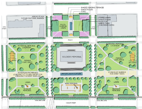
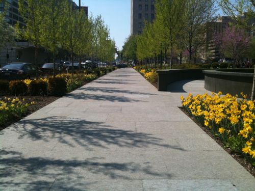
Soon the Missouri History Museum is expected to show final designs for two blocks of the Gateway Mall bounded by 14th, Pine, 13th, and Market — Soldiers’ Memorial & Court 0f Honor. A big unknown is Chestnut Street which runs one-way Eastbound between the two blocks.
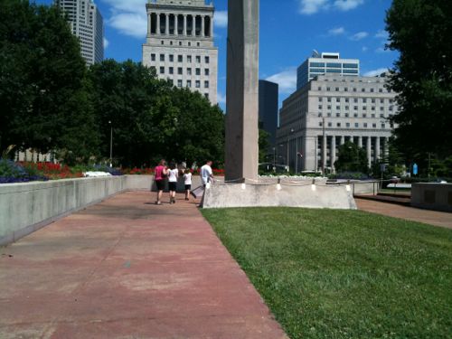
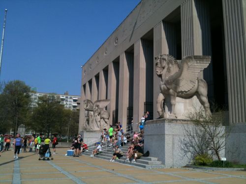
The Gateway Mall Master Plan calls the area around Soldiers’ Memorial the “Civic Room”St. Louis’ Court of Honor, June 2010Soldiers’ Memorial, 2011
Since the Slay administration chose to abandon the Gateway Mall Advisory Board, I don’t know what to expect in the way of review for compliance with the master plan, public input, stakeholder input, etc.
Here are my primary areas of concern:
Festivals
Street grid, traffic flow
Linear hallway along Gateway Mall
Let’s examine each:
FESTIVALS
This might be moot, since the Slay administration ran off great events like the Taste of St. Louis in favor a concert series that never happened:
After a year without major summer festivals in downtown St. Louis, the city may have finally had enough. On Black Friday the mayor’s office announced that it had ended its agreement with Los Angeles-based International Creative Management (ICM) to produce a promised but never held “Summer Rocks” series on the Gateway Mall.
That controversial deal, spearheaded in part by developer Steve Stogel (president of Clayton-based DFC Group) and approved by the city via Festival Reservation Bill 328, blocked out a downtown area from Union Station to City Hall from May to September 2015, and would have continued to do so for another nine years (and possibly more). The non-compete clause had already forced out local festivals like Taste of St. Louis, Ribfest and Bluesweek. (RFT)
The Gateway Mall Master Plan calls for this area to be the city’s main space for festivals. It calls the blocks including, and around, Soldiers’ Memorial the Civic Room:
The Civic Room will create a large uni?ed space well-suited for civic events, markets, festivals and concerts. In order to achieve this, it is anticipated that Chestnut Street would be closed incrementally over time, beginning with temporary closures for festivals, and ultimately consideredfor permanent or seasonal closure, though still allowing emergency and service vehicle access.Chestnut Street should still be hard surfaced with a paving different than surrounding areas, to accommodate tents and other services necessaryfor festivals. Locations for performance stages and cultural or art annexes should be provided to further de?ne the civic character of the space andcreate attractions to activate the Mall.
Before Citygarden was built a few blocks to the East, that area was used for large events as well — the Taste of St. Louis started where Citygarden is now. With this new agreement, the Missouri Historical Society (MHS) will have discretion for the use of the middle of the Civic Room festival area:
Although MHS will not host concerts or festivals that do not meet with the mission of Soldiers Memorial, it is willing to collaborate with festivals held in its neighboring parks for something that is mission driven. For example, MHS might have a wreath laying ceremony during Pride on the Soldiers Memorial grounds for LGBTQ members of the military. (FAQ)
Personally, I’d like to see large festivals held elsewhere, perhaps in & around the new Kiener Plaza? Kiener is closing next month for a 12-14 month makeover, the median will be removed from Market Street.
STREET GRID, TRAFFIC FLOW
I never liked the master plan’s suggestion to eventually close Chestnut St. When you close one block of a street that kills activity on the rest of the open blocks before & after the closure. I’d like to see Chestnut & Pine return to two-way traffic West of Tucker. Then they’d feel like neighborhood streets again rather than very long highway on/off ramps.
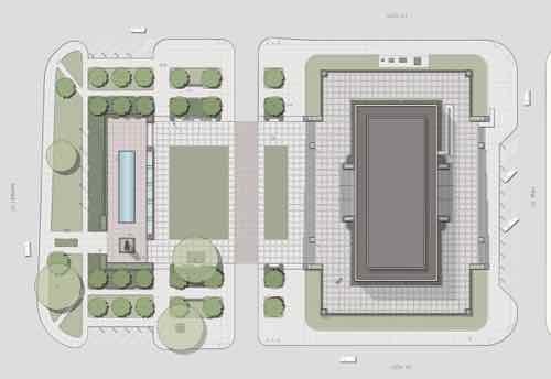
Missouri History Museum drawing from Fall 2015 shows what appears to be a single lane. Final design may be different.
The problem with this draft is it doesn’t show the surrounding context. What about the blocks to the East West, & North? What is the whole concept for all of these blocks? It doesn’t need to be built by the history museum but all needs to be part of the design process — so it’ll all work eventually. Looks like they’re designing this in isolation — an island. Chestnut is two lanes with diagonal parking to the East & West — lanes, crosswalks, curb ramps need to align. Without showing surrounding existing conditions it is hard to determine if these have been considered. Most likely they haven’t.
The new parking-protected bike lane on Chestnut is an issue, but it should’ve been on Olive. That would’ve required building accessible bus stops in the parking lane — Chestnut was picked for the bike lane because it was easier than Olive.
HALLWAY
One of the best parts of the Gateway Mall Master Plan is the hallway concept — a wide tree-lined sidewalk along the North side of Market St.
The Gateway Mall master plan calls for this “hallway” to run from Broadway to 20th
Their preliminary design doesn’t show the hallway. So far we only have the two blocks along Citygarden.
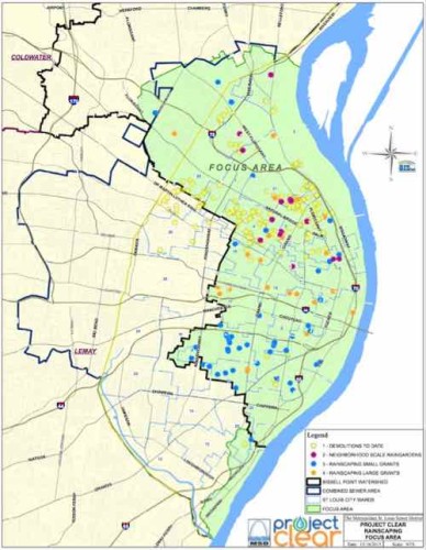
In the recent non-scientific Sunday Poll readers were split on MSD’s plan to raze vacant buildings to reduce water runoff.
Support side 18
Oppose side 17
Neutral+Unsure 7
Below is the breakdown:
Q: To reduce water runoff, the Metropolitan Sewer District (MSD) plans to raze vacant buildings. Oppose or support?
Strongly support 8 [19.05%]
Support 3 [7.14%]
Somewhat support 7 [16.67%]
Neither oppose or support 5 [11.9%]
Somewhat oppose 2 [4.76%]
Oppose 3 [7.14%]
Strongly oppose 12 [28.57%]
Unsure/No Answer 2 [4.76%]
As you can see, the “strongly oppose” answer got the biggest response. Supporters weren’t as enthusiastic. Much of the demolition would happen in neighborhoods struggling to remain relevant.
While it could take several years to spend down the money, even the longest spending scenario would amount to a near doubling of St. Louis’ demolition budget. And areas where MSD sees the most benefit in terms of runoff and watersheds also are the areas – primarily in north St. Louis – where the city’s vacant properties are concentrated.
Those areas are part of the Bissell watershed, where the Environmental Protection Agency has told MSD to better manage stormwater. (Post-Dispatch)
Each time a building is razed it gets harder to convince remaining owners to invest in their properties, to get residents to stay. Still, I need to read more about MSD’s Project Clear.
In 2010 I was appointed to represent the 6th ward on the newly formed Gateway Mall Advisory Board (GMAB). The idea was to mirror how Forest Park is managed — a conservancy made up of the wealthy to help raise money for projects and an advisory board to let the Parks Dept know if proposed projects complied with the Master Plan, or not. Initial terms were staggered, with three year terms thereafter.
Named to the Gateway Mall Conservancy Board were Peter Fischer, GatewayFoundation; Robert Archibald, Missouri Historical Society; Steve Cousins, ArmstrongTeasdale LLP; John Ferring, Plaze, Inc.; David Mesker, retired, A.G. Edwards; EmilyRauh Pulitzer, Pulitzer Foundation for the Arts; Kitty Ratcliffe, St. Louis Convention andVisitors Commission; Henry S. Webber, Washington University; Josephine Weil,Community Volunteer; and Patricia Roland-Hamilton as Executive Director.
Also announced today was the formation of the Gateway Mall Advisory Board, a groupof stakeholders responsible for monitoring the implementation of the Gateway MallMaster Plan and providing ongoing community input about the Gateway Mall. Itscomposition and responsibilities are outlined by City ordinance.
In October 2013 Gary Bess handed out a list at the last GMAB meeting showing the terms of myself and others hadn’t yet expired — see it here. The best word to describe this lists is forged. My original term expired in March 2012 but this new document showed it expires in March 2017 — again the appointments are for three years. Some on this list now showed up with terms expiring in 2017 — impossible since it was just 2013. The next month I emailed Bess and others on the GMAB list to let them know of the discrepancy. Bess was going to look into it.
On December 31, 2015 the private nonprofit Gateway Mall Conservancy was administratively dissolved by the Missouri Secretary of State. Despite being required by ordinance, the GMAB also no longer exists. Our terns all expired, nobody was reappointed or replaced with new appointees. In January 2014 I was asked by Parks & 6th Ward Alderman Ingrassia if I was willing to be reappointed, I said yes to both and submitted the form to reappointed to a public board. Nothing happened.
The Gateway Mall Master Plan calls the area around Soldiers’ Memorial the “Civic Room”, click image to see section
Soon the History Museum will show their plans for two blocks of the “Civic Room” which includes Soldiers’ Memorial but the public body established by ordinance to review proposals no longer exists. In 2010 I had a feeling the city would abandon the Gateway Mall, master plan, and the public review process — I just didn’t think it would happen so quickly.
Flood waters are receding, but what an event — just 22+ years after the 1993 flood. After that flood, we built levees higher. Was that wise? From late last month:
The rising Mississippi River and its tributaries are threatening to overtop 19 federal levees in the St. Louis area. (Fox 2)
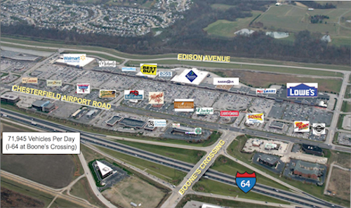
One levee that wasn’t in danger was one that famously failed in 1993 — the Monarch levee. The “gumbo flats” area, now called the Chesterfield Valley, was flooded.
THF’s Chesterfield Commons, with over 2 million square feet, is among many developments built in the floodplain since the 1993 flood
Two outlet malls, a couple of car dealerships, and much more now exist only because of the 500 year levee. How bad is flooding elsewhere because the water can’t spread out here? As we continue developing more land we decrease absorption and increase runoff. Add to that more & higher levees and the situation doesn’t look good.
I have plenty of doubt the levee will prevent a flood in my lifetime, I think I’ll live to see all this development under water.
AARP Livibility Index
The Livability Index scores neighborhoods and communities across the U.S. for the services and amenities that impact your life the most
Built St. Louis
historic architecture of St. Louis, Missouri – mourning the losses, celebrating the survivors.
Geo St. Louis
a guide to geospatial data about the City of St. Louis