At the start of this month I had an appointment with an orthopedic specialist, to get a cast made for a new ankle-foot orthosis (AFO). Orthotic & Prosthetic Design is located at 5467 Highland Park Drive, off of Macklind Ave. between Manchester & Oakland. I’d been there before, usually driving. Once via the #59 MetroBus on Oakland — which goes as far East as the Central West End. With my husband at work with our car, I decided to take the #32 MetroBus — no transfer needed. I boarded at 14th & Washington.
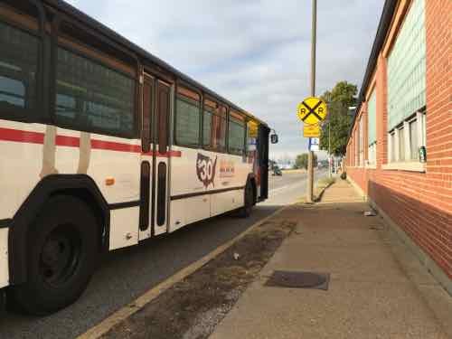
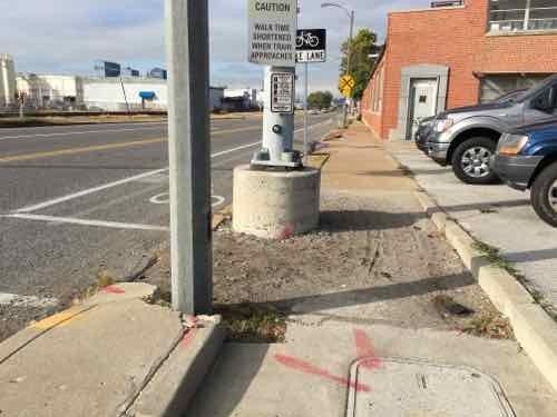
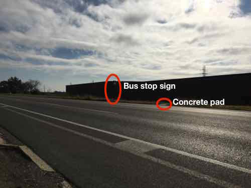
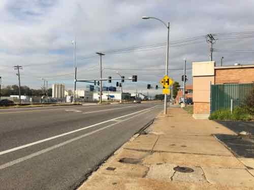
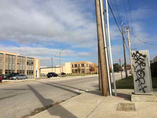
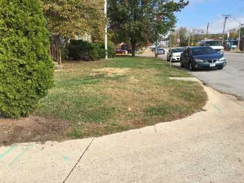
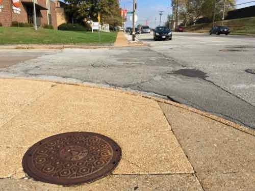
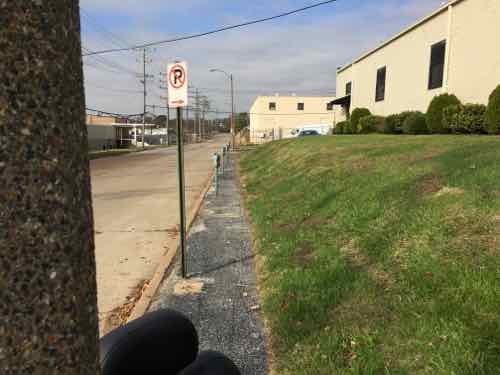
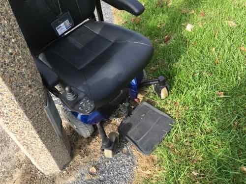
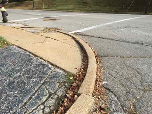
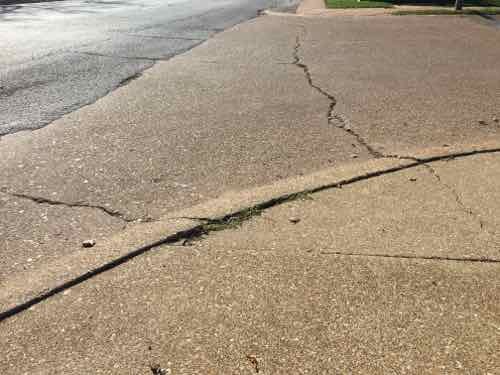
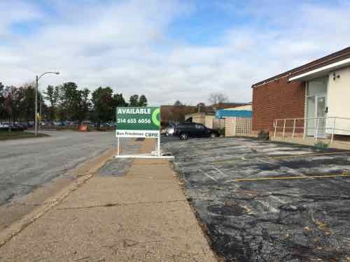
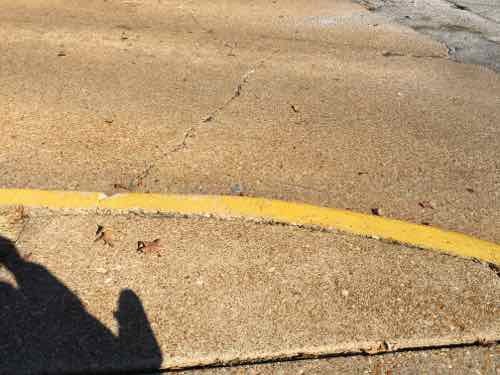
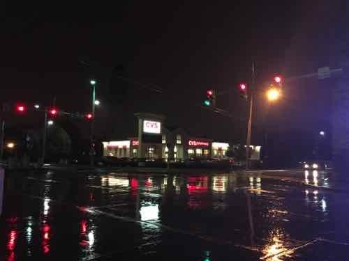
This is the Eastbound #32 I took, the Macklind bus stop is just West of the intersection. I snapped this photo at 9:21am on November 2, 2015. Click image to map bus stop.The lowered section here is to be able to cross Manchester, but it’s filled with debris.I wanted to locate the bus stop for my return trip, it’s East of Macklind. The concrete pad isn’t accessible — no sidewalk to reach it. I’m forced to take a different MetroBus and transfer at the CWE or travel further East or West on Manchester until I find an accessible stop. Click image to view closer view on Google Street View.I rotated back toward Macklind to show you how far away from the intersection I was.To head North on Macklind I can’t go up the East side. The sidewalk is missing behind the corner but just out of view is a curb. My only option is the West side, which is ok because my destination is to the West.At 9:26am I get to 1249 Macklind, owned by American Pulverizer, and see there’s no sidewalk. Rather than risk getting hit in the street, I risk tipping over on uneven ground. If it had rained I might have gotten stuck.In front of the Humane Society I reach Wise Ave — no curb cut on either side. I decide to go West on Wide to cross over to the other side at a driveway.On the North side of Wise Ave I managed to slowly get past the parking meters next to the Pasta House headquarters, but then…I couldn’t get past a light pole because the slope of the grass. I had to stand to get my chair reversed, all while not falling or sending my chair over the curb into the street.So I returned to the driveway off Wise and rode back toward Macklind in the street. But I can’t get onto the sidewalk. I had to choice but to use Macklind Ave — going into a drive and to go around parked cars until I reached a curb ramp or driveway.The next point was the street I needed, Highland Park Drive. No curb ramps here either, but I was able to get over this curb. Others might not be able to.My destination is at the end of the street, but CBRE decided their sign was more important than pedestrians, I went around but the slope & condition of the asphalt was another challenge in a difficult morning, I arrived right on time at 9:40am.After my appointment I headed North to Oakland Ave, at St. Louis Community College I encountered another curb. I used a nearby drive to once again go onto Macklind Ave to get around the lack of a curb cut. Whoever painted it yellow probably didn’t think about wheelchair access.
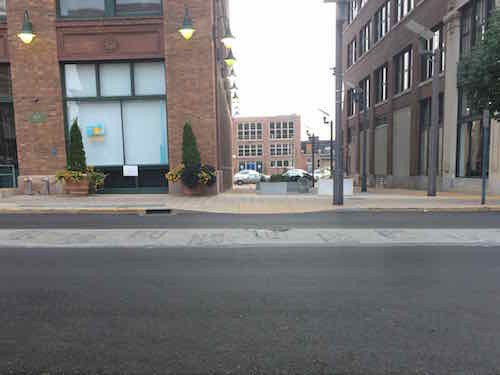
I did reach the bus stop on Oakland — in front of Paraquad.
When the Humane Society of Missouri opened their new headquarters nearly 18 years ago it seems nobody worried about pedestrians reaching the property — no sidewalk to the South and no curb cut to the North. Not sure how long the Pasta House Company has been in their location. And what if my destination had been on the East side of Macklind?
This morning I’ll email a link to this post to various people with the City of St, Louis, Metro, the Humane Society, American Pulverizer, the Pasta House Company, St. Louis Community College, Paraquad, and 24th Ward Alderman Scott Ogilvie. Hopefully they can collectively figure out a plan to make this area comply with the American’s with Disabilities Act of 1990. Twenty-five years is long enough, this shouldn’t still be like this.
Over half of those who voted in the non-scientific Sunday Poll favor retaining the cobblestone zipper design motif in the center of Washington Ave:
Q: Wash Ave’s 12+ year old streetscape includes a cobblestone “zipper” motif down the center, which makes repaving from 14th-18th Streets a challenge. We shou[ld]:
Lose the zipper motif, not important to the well-being of the area 18 [32.14%]
Retain zipper, just don’t resurface the center where cobblestones are located 17 [30.36%]
Retain zipper, incurring extra costs to resurface street 15 [26.79%]
Unsure/No Opinion 5 [8.93%]
Other: 1 [1.79%] “Let the residents decide and let them pay for any extra costs.”
As you can see from the numbers, there isn’t a consensus view.
A recent resurfacing left the center with the cobblestone zipper intact between 14th-18th Streets.
You can count me among those who say rip out the zipper from 14th-18th Streets. The two blocks from Tucker to 14th is different — Washington Ave is brick pavers, not asphalt.
It won’t be long until the new asphalt fades and it’ll be hard to see the difference between the old & new. Setting cobblestones in asphalt was a very poor decision, and as a motif I doubt anyone could guess what it’s supposed to be.
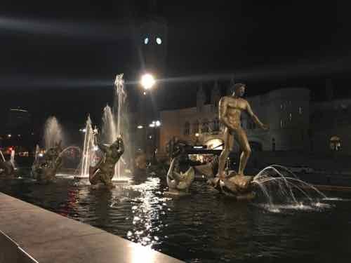
Aloe Plaza, across Market Street from Union Station, used to be very dark at night — too dark. While Kacie Starr Triplett was Alderman of the 6th Ward new lighting was added. The best that can be said is that it’s no longer dark.
Two new light poles were added to shine lights on Carl Milles’ “Meeting of the Waters”:, October 22nd
From a distance, the lighting does a good job. Before nobody wanted to be there after dark because it too dark, but now it’a too bright! Trying to get a good photo with Union Station in the background is impossible.
Not sure how much was spent on this lighting, or if it can be modified. It shouldn’t stay like this.
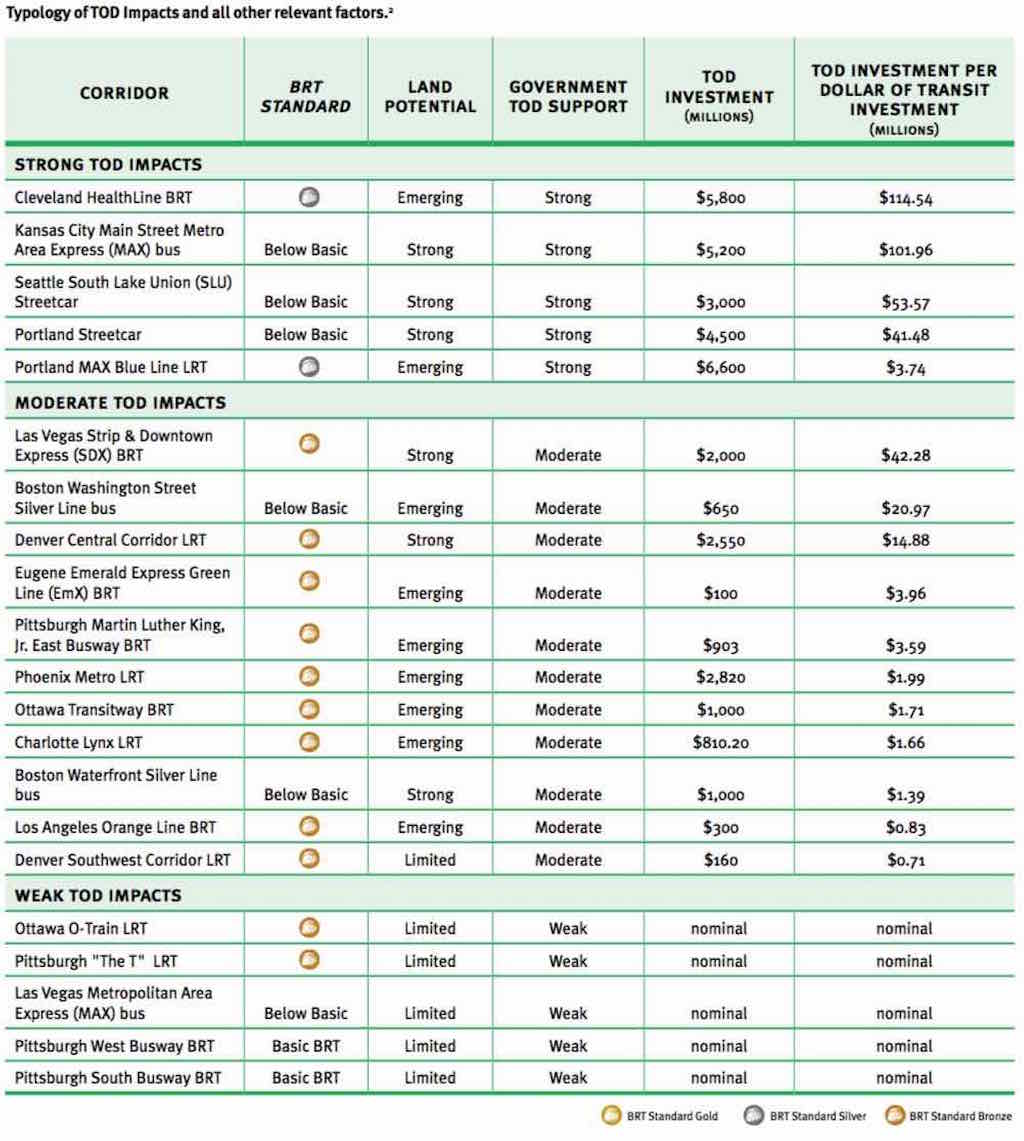
“Per dollar of transit investment, and under similar conditions, BRT can leverage more (development) investment than LRT or streetcars.”
For example, Cleveland’s Healthline, a BRT project completed on Cleveland’s Euclid Avenue in 2008, has generated $5.8 billion in development —$114 for each transit dollar invested. Portland’s Blue Line, a light rail project completed in 1986, generated $3.74 per dollar invested.
and…
The U.S. has seven authentic BRT lines in Cleveland, Las Vegas, Los Angeles, Eugene Ore., and several in Pittsburgh. None achieve the internationally recognized “gold standard” of BRT like Bogota’s TransMilenio line. But one planned for Chicago’s Ashland Avenue might.
“There’s no gold standard BRT in the U.S. yet,” Weinstock said, “but if we continue with the Ashland project on the current trajectory, Ashland could be the first gold in the U.S.”
I’ll address Chicago’s Ashland Ave in a future post. BRT — more development return than LRT or streetcars?
Long-time readers know I love rail — especially streetcars. Public transit was often about real estate development, to get people to a new project, developers would build a streetcar line to get them there. Cities would lease part of the public right-of-way (PROW) so they could operate. Cities, including St. Louis, would have multiple private companies providing public transit. Eventually cities would increase the fees for the track & overhead wires in the PROW or even require the operators to repave roads where they operated. This quickly made streetcar operations unprofitable. One solution, of course, was to abandon the track and use rubber tire vehicles — the bus.
Eventually governments bought up all the private systems — remaining streetcar lines and those that had been converted to bus. Remember, their origin was rooted in the development of real estate. With land developed these lines became strictly about moving people to/from. We need to retuning to the days of the connection between transit and development!
As you can see from the BRT, LRT, and streetcar limes above the return on investment is all over the board. In the top section (Strong TOD Impacts) we see the LRT cost more than the BRT or streetcar lines, but had significantly less development. A return of $3,74 on every dollar looks good until compared to $41.68 or more. Kansas City’s MAX bus line doesn’t even meet the basics to be BRT — yet it has had a return of $101.96 per dollar!
The report begins talking about the Metro subway system in Washington D.C. — a long & costly undertaking:
A growing number of US cities are finding, however, that metro or subway systems are simply too expensive and take too long to implement to effect significant changes in ongoing trends toward suburban sprawl. As such, cities are turning to lower-cost mass transit options such as LRT, BRT, and streetcars. These systems, which frequently use surface streets, are much less expensive and can be built more quickly than heavy-rail subways or metro systems. Over the past decade, some evidence has emerged that some LRT systems in the US have had positive development impacts. Outside of the US, in cities like Curitiba, Brazil, and Guangzhou, China, there is copious evidence that BRT systems have successfully stimulated development. Curitiba’s early silver-standard BRT corridors, completed in the 1970s, were developed together with a master plan that concentrated development along them. The population growth along the corridor rate was 98% between 1980 and 1985, compared to an average citywide population growth rate of only 9.5%. However, because bronze-, silver-, or gold-standard BRT is still relatively new to the US, evidence of the impact of good-quality BRT on domestic development is only now beginning to emerge and has been largely undocumented. (p14)
A detailed look at the Corridors with Strong TOD Impacts begins on page 110:
The analysis shows that all of the corridors in the Strong TOD Impacts category had Strong government TOD support and either Emerging or Strong land potential.
The only two transit corridors in our study that rate above bronze — the Cleveland HealthLine BRT and the Blue Line LRT — both fell into the Strong TOD Impacts category and were in Emerging land markets. The Blue Line LRT leveraged $6.6 billion in new TOD investments, and the Cleveland HealthLine BRT leveraged $5.8 billion, making them the two most successful transit investments in the country from a TOD perspective. Portland achieved this over a much longer time period and in a stronger economy than Cleveland did.
In the Strong TOD Impacts category, three corridors with below-basic-quality transit had Strong land development potential and Strong government TOD support: the Portland Streetcar, the Seattle SLU Streetcar, and the Kansas City Main Street MAX.
In each of these cases, local developers and development authorities did not feel that the transit investment was all that critical to the TOD impacts. Thus, we can conclude that if the land market is strong enough, and the government TOD efforts strong enough, a below-basic transit investment might suffice; but a higher-quality transit investment could have even greater impacts.
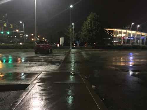
Not all of the investment along Cleveland’s Healthline is urban. We visited this CVS — built right after the line opened. The building is set back behind a fenced parking lot.
A typical suburban CVS is among the new development along Cleveland’s Healthline. Click image to view in Google Maps.Like most newer CVS stores, it has an ADA accessible route out to the public sidewalk. In this view from the entry pedestrians must go left to the intersection to reach the EB & WB stations. If the entry were at the corner less walking would be required.
As I noted previously. a lot of the new development was on college & hospital campuses — it would’ve happened anyway — but it faces the street rather than looking internal (like SLU, BJC, etc).
I’ve got to read the full report a few more times so absorb it all — while recognizing it was written with a pro-BRT viewpoint.
Any TOD effort is most successful when land-use planning and urban development efforts are concentrated around a high-quality mass transit corridor that serves land with inherent development potential. Assistance from regional and city-level agencies, community development corporations, and local stakeholders can help create more targeted policies to direct development to such transit corridors. Local foundations can be critical to the process of funding redevelopment and providing capital and equity for projects. Local NGOs, which can communicate the projects to the public to help broaden support, are also important.
Although cities in the US are still far from fully transforming their declined urban neighborhoods into high-quality, mixed-use urban developments, they are well on their way. Gold-, silver-, or bronze-standard BRT, when combined with institutional, financial, and planning support for TOD, is proving to be a cost-effective way of rebuilding our cities into more livable, transit-oriented communities.
Regardless of their bias, the above is true — we’ve invested hundreds of millions in light rail and have little TOD to show for it because of poor land-use planning.
Like streetcars & LRT, I think BRT is a great option to consider in the St. Louis region, We can argue about the mode, but we need to take action to have land-use planning that will strongly support transit-oriented development!
AARP Livibility Index
The Livability Index scores neighborhoods and communities across the U.S. for the services and amenities that impact your life the most
Built St. Louis
historic architecture of St. Louis, Missouri – mourning the losses, celebrating the survivors.
Geo St. Louis
a guide to geospatial data about the City of St. Louis