“Lingering Not Loitering” – Dan Burden
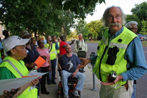
 

ABOVE: Dan Burden (right) leads a "walking audit" on Delmar just west of Union. Photo credit: Lou Tobian/AARP

“Lingering Not Loitering” was the phrase I heard most often from walkability expert Dan Burden when he visited St. Louis recently, his response to University City attempting to keep pedestrians moving (story). I agree, we need more pedestrians lingering on our sidewalks.  Thankfully University City official voted down this controversial bill yesterday (story).

So who is this expert?

He Takes Back the Streets for Walking

Burden, 58, puts bloated thoroughfares on what he calls a “road diet.” In cities as large as Las Vegas, Toronto and Seattle and hamlets as small as Sammamish, Wash., he has trimmed lanes and filled the space with bike routes or a grassy buffer between the asphalt and the sidewalk to ease walkers’ stress. Of course, motorists tend to react to Burden as they might to a jackknifed manure spreader directly in their path. “They say ,’We already have a traffic problem,'” says Burden, “‘and now you want to take lanes away?'”

That’s exactly what he wants to do. But Burden isn’t an autocrat. His preternatural calm — he was a National Geographic photographer before founding Walkable in 1996 — sets people at ease. He knows that slimmer roads are “leaner, safer and more efficient,” and that they take some of the stress off drivers too. “We tend not to like open, scary places, and we try to get through them quicker. Somehow the canopy effect of tree-lined streets slows traffic.” Burden can’t eliminate road rage. But for some drivers, riders and pedestrians across the country, he can create road repose. (Time Magazine)

Burden is now the Executive Director of the Walkable and Livable Communities Institute.
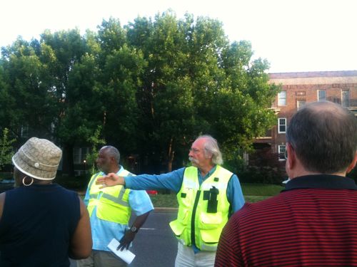
ABOVE: 26th Ward alderman Frank Williamson (left) with Dan Burden (right) pointing out an issue to everyone.

I joined Burden and residents on the two walking audits conducted on Tuesday May 24th. The starting point for both was ConnectCare located at 5535 Delmar Blvd.  That morning we went north on Belt Ave, west on Cates Ave, south on the Ruth Porter Mall and east on Delmar back to ConnectCare.
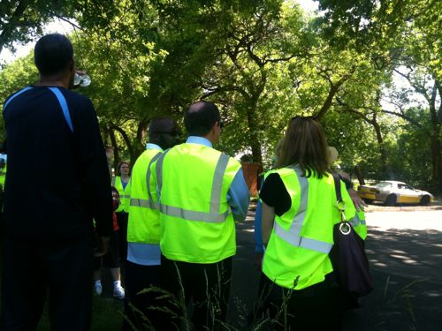
ABOVE: St. Louis Mayor Francis Slay (center) joined for part of the morning walk. Here we are on Belt Ave across from Ivory Perry Park.

So what were his comments on the audits and the presentation the night before?

  • Design standards dictate how roads are designed, but within the same standards you can get very different results. Most often we get roads that create poor pedestrian environments  — excessively wide lanes with the resulting fast traffic.  But the design standards also allow for roads that work well for motorists, pedestrians and bicyclists alike.
  • Lanes are often too wide – say 12ft rather than 10ft.
  • Paint is cheap, a right stripe to separate the  outside lane from the parking lane is a cost effective way to slow traffic.
  • Roads that have had diets often still move as many cars as before.
  • “bulbs” at corners can help cut the distance pedestrians must walk to cross a road in half.
  • On-street parking is good because it slows traffic.
  • Buildings must watch over sidewalks so pedestrians feel safe.

Here is an excellent video featuring Dan Burden:

httpv://www.youtube.com/watch?v=Vcx08S1l-CQ

It was a pleasure meeting him and his staff, it has inspired me to do more.

– Steve Patterson


St. Charles County Needs Public Transit

St. Charles County now has more people than the City of St. Louis (360,484 vs 319,294).  That population is spread out over a much larger area giving the county a low population density of 643/sq mi compared to St. Louis City which has a density of 5,158/sq mi.   St. Louis County’s population density is 1,966/sq mi.  One might conclude from these numbers that St. Charles County lacks the density to support transit.

In Illinois, St. Clair County contracts with Metro for transit service despite having a population density of only 393/sq mi (270,056). In addition to bus service, they funded and built an extension to the MetroLink light rail line.  In neighboring Madison County, the population density is a mere 366/sq mi yet they have the separate Madison County Transit (MTC MCT) system.

Again, St. Charles County has no county-wide transit service.  The City of St. Charles operates the horribly named SCAT (St. Charles Area Transit) system but that is little more than a senior shuttle service.

The St. Charles Area Transit system, otherwise known as SCAT, consists of five bus routes that provide transportation to various locations within the City of St. Charles as well as to the Metrolink North Hanley Station. Curb-to-curb service is provided for all riders, and all busses are equipped with wheelchair lifts.

All routes run Monday through Friday. Please allow 5-10 minutes leeway for each time listed. The routes and schedules are subject to change.

I have a copy of the fold out paper map showing the routes, none are online (wtf?). Yes, seniors need such systems but what about others? What about the other 294,691 St. Charles County residents that don’t live in the City of St. Charles?

In terms of its growth spurt, St. Charles may still be in its tweens.

“We’re probably kind of in the middle,” Anthony [director of community development with St. Charles County] says. The county estimates that its maximum capacity is about 640,000 people, he says, considerably more than the county’s current population of 360,484.)

With much more growth ahead, the county and cities within it have several things to consider moving forward, chiefly the very things that brought people out in the first place. (STL Beacon)

More growth with no plan to get folks from home in Wenzville to work in O’Fallon?  Part of me would like to just sit back and wait for the realities of an aging population combined with rising fuel prices to sink in to the average St. Charles County resident. But by the time that happens they will be in crisis mode. As part of our 16 county region we can’t allow such a large area fall into transportation crisis.

I’m not the first to realize St. Charles County needs a system. They created the St. Charles County Transit Authority and East-West Gateway studied the idea in 2006-07, an update to a 2001 plan.

East-West Gateway suggested that a sales-tax of 1/8 cent (or less) could support the proposed system which would, in turn, provide the local workforce with a transit option that is financially and environmentally friendly.

Polling commissioned by the Transit Authority in January 2008 and paid for by private donations did not indicate sufficient support for a sales tax for public transit. Voters opposed a bus sales tax for two main reasons:

  1. taxes are already “too high” or
  2. this particular tax would be an “unwise” use of taxes.

In addition, a large group (20%) stated they would not use the bus system or would not access it because its proposed routing is not convenient for them. (source)

Leaders in St. Charles County need to work on passing a transit tax so the Transit Authority can begin the work of setting up a transit system.

– Steve Patterson


Poll: When Will St. Charles County Go Smoke-Free?

Interesting news from St. Charles County last week:

The fate of a proposed countywide smoking ban is now up to County Executive Steve Ehlmann.

The County Council voted 4-2 on Tuesday night for legislation to put the proposal on the November 2012 election ballot. Ehlmann has yet to signal whether he’ll sign or veto the measure, which would apply to bars, restaurants and most other indoor public places. (STLToday.com)

With St. Louis City & County now smoke-free, with some unfortunate exceptions, it would be nice to see more of the region become smoke-free.

He [Ehlman] has 10 days to veto or sign the bill. If he does neither, the bill is automatically approved. (Patch.com)

This is the subject of the poll this week: When Will St. Charles County Go Smoke-Free?  The poll is located in the upper right corner of the blog.

I hope Steve Ehlmann doesn’t veto this bill so the question goes to voters in November 2012.

– Steve Patterson


Happy 137th Birthday to the Eads Bridge

ABOVE: Eads Bridge May 2010

When I moved to St. Louis, almost 21 years ago, I immediately fell in love with Eads Bridge. The rail lines on the lower level of the bridge hadn’t been used in 15 or so years. The road deck was in place but it was removed during construction of the  MetroLink light rail that opened in 1993. The bridge was so beautiful to my young eyes.

ABOVE: Eads Bridge with the Admiral in early 1991
ABOVE: Eads Bridge in early 1991

The history of the bridge is fascinating.  It opened 137 years ago today on June 4, 1874 with the official dedication was a month later on July 4, 1874:

The bridge is named for its designer and builder, James B. Eads. When completed in 1874, the Eads Bridge was the longest arch bridge in the world, with an overall length of 6,442 feet (1,964 m). The ribbed steel arch spans were considered daring, as was the use of steel as a primary structural material: it was the first such use of true steel in a major bridge project.

The Eads Bridge was also the first bridge to be built using cantilever support methods exclusively, and one of the first to make use of pneumatic caissons. The Eads Bridge caissons, still among the deepest ever sunk, were responsible for one of the first major outbreaks of “caisson disease” (also known as “the bends” or decompression sickness). Fifteen workers died, two other workers were permanently disabled, and 77 were severely afflicted.

On 14 June 1874, John Robinson led a “test elephant” on a stroll across the new Eads Bridge to prove it was safe. A big crowd cheered as the elephant from a traveling circus lumbered towards Illinois. It was believed that elephants had instincts that would keep them from setting foot on unsafe structures. Two weeks later, Eads sent 14 locomotives back and forth across the bridge at one time.

The Eads Bridge, which became an iconic image of the city of St. Louis, from the time of its erection until 1965 when the Gateway Arch was constructed, is still in use. The bridge crosses the St. Louis riverfront between Laclede’s Landing, to the north, and the grounds of the Gateway Arch, to the south. Today the road deck has been restored, allowing vehicular and pedestrian traffic to cross the river. The St. Louis MetroLink light rail line has used the rail deck since 1993. (Wikipedia)

This bridge, and the railroad tunnels under downtown, allowed the first Union Station to open a year later on June 1, 1875.  This Union Station was located at 12th (now Tucker) & Poplar. The Union Station we know opened 6 blocks to the west just 19 years later on September 1, 1894.

In 2024 we need to have a big party to celebrate the 150th anniversary of Eads Bridge.  Hopefully by then the raised section of I-70 at the west end of the bridge will be gone, opening sight lines.

– Steve Patterson


Sprawl in South County 20 Years Ago

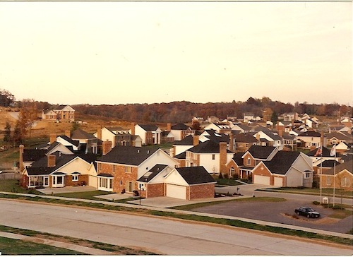
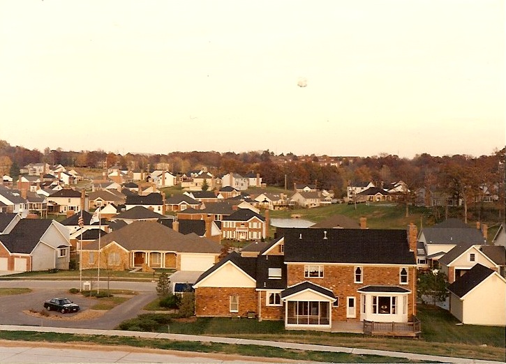
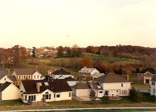
In 1991 I took these three pictures somewhere in south St. Louis County. The three pics were taken from the same spot rotating from left to right.

At the time it was a new subdivision.  Note that some homes have front-facing garages while others have rear-entry garages and paved backyards.

I just wish I could remember the location so I could return. Maybe it is best I don’t know, I’m sure they lovely rolling hills in the background has now been destroyed by two decades of “progress”.  I’m also pretty sure all those new streets still lack shade trees.

– Steve Patterson


Advertisement


[custom-facebook-feed]

Archives

Categories

Advertisement


Subscribe