Home » Downtown » Recent Articles:

Two Locally Preferred Bus Rapid Transit (BRT) Routes Selected

In September readers picked the I-64 BRT route between downtown and Chesterfield as their favorite of four bus rapid transit (BRT) routes being studied by the Transportation Corridor Improvement Group (TCIG), which “consists of staff from Metro, EWGCOG, the City of St. Louis, St. Louis County, and MoDOT”.

“None” was 2nd in the poll, but the next actual route favored was the West Florissant – Natural Bridge BRT option. On Tuesday the TCIG recommended two locally preferred alternative routes to Metro’s Operations Committee

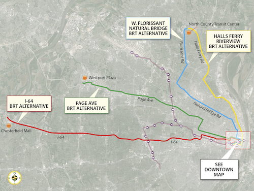
After careful consideration and analysis of the transportation corridors, the TCIG recommended as the locally-preferred alternative two BRT projects: I-64 between Chesterfield and Downtown St. Louis, and a north-south route connecting North St. Louis County to Downtown St. Louis primarily via West Florissant Avenue and Natural Bridge Avenue.

See their report/presentation here.

The four alternative BRT routes that were being studied.
The four alternative BRT routes that were being studied, click image to view larger version.

Let’s take a closer look at the two selected routes, from Tuesday’s report:

I-64 BRT (route)

The 1-64 BRT corridor spans 23 miles between the City of Chesterfield and Downtown St. Louis. It would serve a limited number of park-and-ride stations along I-64 between Chesterfield Mall and the Central West End. From the Central West End it would travel along Forest Park Avenue into Downtown St. Louis, making a loop through Downtown before ending at the Civic Center Station. As currently proposed, its service frequencies would match MetroLink, and transit prioritization strategies would be implemented along the corridor to speed transit travel.

The I-64 BRT would serve a Central Corridor that hosts 55,000 people and 115,500 jobs within one half-mile, outside of Downtown St. Louis. The addition of this high-performance service to the Metro System would provide the region’s first rail-like transit option in West St. Louis County, offering the first opportunity for all-day, single-seat service between Chesterfield and Downtown St. Louis, and reducing transfers from other areas by half. Along with reducing transfers, it would improve transit travel time within the corridor by 30%, making it a much more attractive alternative to the personal automobile. Ridership projections from EWGCOG’s regional travel demand model show a potential ridership market of 5,100 weekday riders, 2,100 (41%) of whom would be new “choice” riders. That market is projected to grow to 6,800 weekday riders by 2040.

I-64 BRT CONSUMER BENEFIT

  • End-to-end transit travel time reduced from 76 minutes to 53 minutes
  • – Compared to auto travel time of 25 minutes
  • – Offers motorists option of comfortable, affordable, productive commute
  • Corridor ridership projected to increase 357% from 1,115 to 5,100 weekday riders opening year; 6,800 in 2040
  • – 2,100 (41%) new “choice” riders opening year
  • Enhanced service
  • – BRT option provides single-seat service not currently available
  • – Reduce transfers by 50%
  • – End-to-end service available all day, rather than only peak
  • – Create additional hubs to make local bus service more efficient

This route makes a lot of sense to me. It gets a higher level of transit service on this corridor without the enormous infrastructure expense that would be required for light rail. It would run down Forest Park Ave & Boyle, running right past the proposed IKEA and connecting with the proposed new CORTEX MetroLink station. Transit time would be reduced from three times driving to twice driving. For some that’s still a non-starter, but for others it would allow them to avoid  driving/parking headaches while being able to be productive. It doesn’t need to get every driver out of their cars to be a success.

West Florissant – Natural Bridge BRT (route)

The other transit project included in the LPA is an arterial-based BRT route connecting North St. Louis County to Downtown St. Louis. This service would operate out of the new North County Transit Center, running 16 miles to Downtown via West Florissant Avenue, Lucas and Hunt Road, and Natural Bridge Avenue. As currently proposed, its service frequencies would match MetroLink; stations with a high level of customer amenities would be spaced a minimum of one mile apart; and transit prioritization strategies would be implemented to speed travel.

The combined West Florissant-Natural Bridge corridor hosts 70,000 people and 18,000 jobs within a half-mile, not counting Downtown St. Louis. Supplementing the local bus network in this strong and proven transit market will give residents of North St. Louis City and near-North County their first high-performance, rail-like transit option. It will reduce transit travel time and any required transfers by half. It would also greatly improve access and travel time between some of the region’s most disadvantaged areas and major jobs centers in Downtown and the Central Corridor, particularly if paired with the I-64 BRT option. Ridership projections from EWGCOG’s travel demand model show a potential ridership market of 3,200 weekday riders, 600 (19%) of whom would be new “choice” riders.

W. FLORISSANT–NATURAL BRIDGE BRT CONSUMER BENEFIT

  • End-to-end transit travel time reduced from 85 minutes to 42 minutes
  • – Compared to auto travel time of 25 minutes
  • – Attractive amenity package offers affordable, comfortable commute
  • Corridor ridership projected to increase 23% from 2,610 to 3,200 opening year and 2040 (Natural Bridge)
  • 600 (19%) new “choice” riders
  • Enhanced service
  • BRT option supports fast single-seat ride to Downtown St. Louis
  • If paired with I-64 BRT, travel from North County to CWE and West County would require only 1 transfer between 2 high-speed routes; currently requires multiple transfers and 2-3 local routes

Unlike going to Chesterfield, reaching downtown from North St. Louis County isn’t very direct via car or transit. This will help reduce travel time for existing transit users and is expected to attract new riders. The streetscape improvements along the route will benefit everyone in the area.

Additional information

Travel speeds competitive with MetroLink

  • Avg MO MetroBus speed = 16.02 mph
  • Avg MO MetroLink speed = 25.63 mph
  • I-64 BRT speed = 26.04 mph
  • WFNB BRT speed = 25.71 mph

The report has very detailed cost projections, here’s the summary:

  • I-64 BRT: $37.9M capital; $4M net operating
  • West Florissant – Natural Bridge BRT: $39.1M capital; $2.6M net operating

Additional operational revenue would be necessary for this additional service.

Next Steps

Metro’s board is expected to vote to approve these two locally preferred routes at their March 28th meeting.  If approved it goes to East-West Gateway Council of Governments, the Metropolitan Planning Organization (MPO) for the St. Louis region. Once part of our 2040 transportation plan we can seek capital funding through the Federal Transit Administration’s Small Starts program.

Again, much more detail is with the report/presentation from Tuesday.

— Steve Patterson


Wrap on New Downtown Trolley Buses a Great Improvement

The #99 Downtown Trolley, regular buses with a cartoon wrap, have been on the streets since July 2010. People laugh at the wrap but it’s effective.

The original Downtown Trolley used a short bus with steps & wheelchair lift.  Photo by Jim Merkel, Suburban Journals
The original Downtown Trolley used a short bus with steps & wheelchair lift. This is me exiting the trolley at the July 2010 debut. Photo by Jim Merkel, Suburban Journals

The one problem with the original is the wrap made it impossible to see out the side windows. Tourists & locals unable to see the city….no good. Recently the original trolley buses were replaced by new Gillig low-floor buses.

The wrap on the new buses looks like the original
The wrap on the new buses looks very similar the original, with one major difference…
The new wrap allows passengers inside to see out
The new wrap allows passengers inside to see out, this is looking north on 7th from Market

I love the new Gillig low-floor buses, so much quicker & easier to board/unboard, but the ability to see out is a huge improvement, a very pleasant surprise!  The wrap is licensed from a company that holds the rights to use a trolley likeness.

— Steve Patterson


Koplar Properties Allowing Historic Streetcar Power Station Roof To Cave In

The historic Cupples 7 warehouse was razed last year because owners let a small hole in the roof become a big hole over the years, destroying the structure.  Last week an aerial image of similar roof damage at Lemp Brewery was posted on Facebook.

I’ve seen similar holes in the roof of the old power station on Locust, but the visible ones on the west side are nearly impossible to photograph.  But yesterday I got a chance to photograph damage on the east side of the roof.

1711 Locust was a power station for the original streetcar system, it is vacant and in disrepair.
Roof of 1701 Locust in the foreground, 1711 Locust behind it.
Roof of 1701 Locust in the foreground, 1711 Locust attached
Cropped view of damage
Cropped view of damage, allowing water & snow into the building 

Here’s information on the building:

This tall , one story power sub station was constructed in 1903 for the St. Louis Transit Company. Stately pilasters define three bays a center bay with three segmentally arched, very narrow tall windows and bays to each side with two segmentally arched openings. Quoins and voussoirs -frame? the segment-ally arched entrance at the lower portion of the easternmost bay. A large pediment, embellished with wreath, is superimposed in front of the parapet. The west elevation is divided into 11 bays each with two segmental1y arched blind windows. (Washington Ave Historic District

The owner is 1711 LOCUST LLC located at Maryland Plaza, Suite 300 — the offices of Koplar Properties. The last sale on city records is for $385,000 on 12/17/2007. We can’t keep letting people allow their properties fall apart while the rest of us get cited for peeling paint.

— Steve Patterson


Another Parking Meter Test Starts Monday

The previous St. Louis Treasurer, Larry Williams, conducted limited testing of modern parking collection technology on South Grand in 2006. There were a couple of blocks of pay-per-space and a few pay-n-display. (FYI: In St. Louis the treasurer is responsible for parking revenue.)

What’s the difference between the two types?

  • With pay-per-space each fixed-length parking space is assigned a number. After parking you walk to a nearby pay station, enter the space number where you  parked, and pay.
  • With pay-n-display you park, walk to a nearby pay station, buy time, return to your vehicle and display  the receipt on the inside of the windshield.

Each has pros & cons compared to each other and against individual meters. In 2006 it was concluded neither pay-per-space or pay-n-display were right for St. Louis. I say the design of the test was flawed — only 2-3 blocks of each and they were next to each other. Someone might park in front of a store and use pay-per-space and a few days later park a block away and use pay-n-display.

A pay=per-space station on South Grand, November 10, 2006
A pay-per-space station on South Grand, November 10, 2006
A pay-n-display machine on South Grand in April 2006
A pay-n-display station on South Grand, November 10 2006

Monday St. Louis Treasurer Tishaura Jones will announce new pilot programs testing new parking technology. The treasurer’s office director of communications, Deborah Johnson, told me via email:

The city has previously tested “pay-n-display” units, where the customer must walk to the unit, print a ticket, and walk back to their car to display the ticket. The multi-space units this pilot is testing will use the “pay by space” method, where the customer types in the 4 digit space number they are parked in and does not have to return to their vehicle to place a ticket. Instead, the system automatically monitors and communicates with enforcement officers.

I reminded her both pay-per-space & pay-n-display were tested simultaneously.

In response to another question she said:

The pilots are in four locations in the city: 10th Street between Chestnut and Washington; Broadway and Pine; Euclid and Laclede; and Euclid and Maryland. The pilot will be in place for six months.

The new equipment is already installed on 10th Street, I posted the following picture to Twitter & Facebook yesterday:

Pay-per-space meter installed on 10th, will be functional starting Monday
Pay-per-space stations on 10th will be functional starting Monday

Of note is the stations on 10th accept coins, bills, and credit cards. You’ll even be able to extend the amount of time via phone!

Instructions to extend time, click image to view website.
Instructions to extend time, click image to view the mobile-optimized website.

From the site:

Extend-by-Phone is an innovative service that enables the parking meter to send you a text message reminder when your parking is about to expire, and allows you to add time to your parking by simply replying to the reminder message with the amount of additional minutes you need.

The FAQ answers common questions, such as fees.  Of course this could mean even more people stay parked longer than the 2-hour limit, see St. Louis Not Enforcing Short-Term Parking Limits.

Small signs with numbers replaced the meters on 10th

I’m glad to see recent testing isn’t limited to a very tiny test area as in 2006. I also appreciate the caution given the infrastructure costs to change, but I’d hoped for something more modern years ago. Treasurer Jones has only been in office a little over a year and for someone who campaigned on not wanting to be a “parking czar” she and her staff are making changes at a record pace compared to her predecessor.

I look foreword to hearing the official details on Monday.

— Steve Patterson


A Look at the Butler Brothers Warehouse

For over six years now I’ve had a decent view of the 17th Street facade of the massive Butler Brothers warehouse also bounded by Locust, Olive, & 18th (map).

Butler Bros Warehouse, as seen from my windows

So when a neighbor posted a link to  ‘718,000sf Butler Brothers Building Set for Residential Redevelopment’ on our condo association listserve I was very interested to hear the development plans. Is residential development imminent? Nope.  The owner has simply listed the property with a different commercial brokerage.

In November 2007 Hilliker was marketing space for lease in the building

This was the peak of the condo boom downtown, developers were grabbing buildings as fast as they could. The sheer size of Butler Brothers, however, presented overwhelming challenges to potential developers. The Ely Walker building, on the opposite side of my building, was just being finished as lofts by Orchard Development Group of Chicago.  Ely Walker was very large, but not as big:

Originally known as the Ely and Walker Dry Goods Company Building, this seven story building is second only to the Butler Building in overall size. (National Register Nomination — Washington Avenue Historic District)

Part of the marketing in 2007/2008 was also trying to sell the building to a developer like Orchard or Pyramid, but the bottom was falling out. In April 2008 Pyramid went under and in September the stock market crashed. Since then buildings have been rehabbed, now as smaller rental units. Orchard couldn’t sell all the condos in the Ely Walker so their marketing switched to rental.

The market has recovered somewhat, though not for new high-end condos. The existing resale market is coming back, prices have mostly recovered.   That said, nobody is building new for sale loft condos.  The market is good for rental units but with a building this size I’m not sure about such a large number of units coming on the market. Figuring out the right price range(s) and construction/permanent financing will be tricky, seller financing is an option though. Tax credits will be part of the picture:

The property is listed in the National Register of Historic Places and is presently approved for State and Federal Historic Tax Credits to support redevelopment costs.

Well, not exactly. The building isn’t listed individually on the national register, but it’s a contributing structure in the Washington Avenue Historic District. As a contributing building any redevelopment might qualify for historic tax credits. Like prior years, some in Jefferson City want to cap historic preservation and low-invome housing tax credits.

Let’s go for a walk around the building…

The west facade facing 18th is the tallest due ti the grade change.
The west facade facing 18th is the tallest due ti the grade change. Oct 2012
The development concept being marketed includes retail on one side -- 18th,
The development concept being marketed includes retail on one side, facing 18th St. This was the original building entrance. The original address was 300-320 N. 18th. The sidewalk can be adjusted to create an accessible entry.
In the 1950s the entrance was moved to 1717 Olive. Preservation tax credits might require the removal of this 50s look to return to the original.
In the 1950s the entrance was moved to 1717 Olive. Preservation tax credits might require the removal of this 50s look to return to the original. This entry has never been accessible to wheelchairs.
To the east of the 50s entry you can see where two brick columns were removed to create a storefront.
The docks along 17th were still being used in November 2007
Three wide gated openings are on the center of the 17th St side, one leading to the small light well. Some creative options exist here.
Three wide gated openings are on the center of the 17th St side, one leading to the small light well. Some creative options exist here. Nov 2007
The gates haven't been opened for a while. This is also considered a historic facade since it faces s public street
The gates haven’t been opened for a while. This is also considered a historic facade since it faces s public street
On Locust we see the entry added in the 50s, opposite the Olive entry.

As an immediate neighbor I hope the building sells quickly and gets redeveloped, but I’m not going to hold my breath in the meantime. If the proposed streetcar on Olive moves forward I think interest in this property will as well. There’s plenty of room for structured parking inside, but the streetcar would connect it to the CBD, Midtown and CWE.

— Steve Patterson


Advertisement


[custom-facebook-feed]

Archives

Categories

Advertisement


Subscribe