October 31, 2023Featured, Steve PattersonComments Off on Celebrating Blog’s 19th Anniversary
Nineteen year ago I started this blog as a distraction from my father’s heart attack and slow recovery. It was late 2004 and social media & video streaming apps didn’t exist yet — or at least not widely available to the general public. Blogs were the newest means of communication and I jumped in with both feet. This blog’s popularity peaked in 2006.
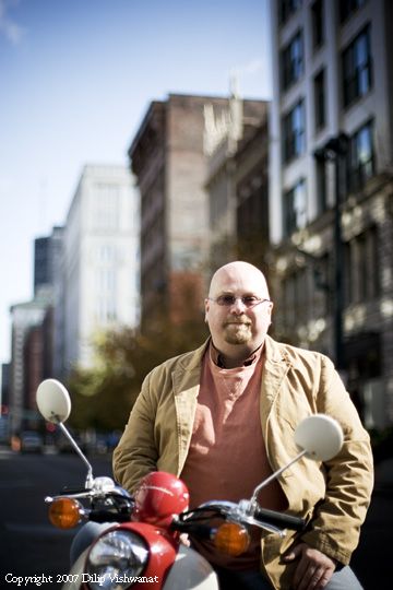
Me pre-stroke in the December 2006 issue of St. Louis Magazine. I now weigh less than half of what I did here. Photo by Dillip Vishwanat
A lot has happened over the last 19 years. St. Louis’ population has continued to decline, although it has slowed. The decline now is mainly in predominantly black northside wards. Recently we cut the number of wards in half, from 28 to 14. Many vacant buildings have been renovated — both small & big/historic.
On a personal level my mom died in 2006, my dad on New Years Day 2008. A month later I had a massive hemorrhagic stroke at home…along. Amazingly I was still alive 15-16 hours later when a friend found me on the cold concrete floor of the loft I‘d moved into just a few months earlier — at no point did I ditch my atheism even though I was pretty sure I’d be dead when found. I came home from the 3rd hospital/therapy three months later on April 30, 2008.
Eleven years ago next month (Nov 2012) I met a man 16+ years younger than myself, we got legally married in June 2004 – in East St. Louis, with the Arch & St. Louis skyline as the backdrop. Nearly 5 years ago we moved into an apartment in the mixed-income HOPE VI development that replaced the Cochran Gardens high rise public housing project just north of downtown/central business district.
Four years ago my biggest challenge ever appeared on a routine chest X-Ray: stage four kidney cancer. As I’ve stated before it will eventually kill me. In the meantime life continues — not as a battle, fight, etc. It continues with grocery shopping, laundry, sourdough bread, birthdays, Grand Theft Auto online (recently achieved rank 1,000!), gardening, travel, etc. When I die I don’t want people saying I had a ”long battle.” Instead, I want the narrative to be that I “enjoyed life during the x years since diagnosis.”
Unfortunately I’ve had so much living going on I’ve neglected this blog. I have a long list of subjects to weigh in on, but focusing on getting a post written, edited, and posted is getting harder. We’re still adjusting to my husband’s schedule at his excellent job at Barnes-Jewish Hospital — he just returned to the day shift but will be back on nights in January 2024.
Blogger Steve Patterson on the Gateway Mall hallway, Citygarden. May 2021. Photo credit: Humans of St. Louis
Living as long as I have I’m experiencing things others before me wouldn’t have. First, as of April I’m on my 3rd line of immunotherapy treatment. No more infusions every 4 weeks, just daily pills. Since December 2022 I’ve had a constant pain between my shoulder blades. Now that I’m on a compatible drug combo, targeted radiation to address my pain was an option. Yesterday I had my first of 5 radiation treatments on my largest tumor, my last is Friday.
My hope is the pain will be low enough, or gone, that I can cease taking the opioid Oxycodone — then I won’t be as sleepy.
Despite everything health wise, I’m enjoying the passage of time. I’m looking forward to my 10th wedding anniversary in June, and the 20th annIversary of this blog a year from today.
— Steve ———————————————————————— St. Louis urban planning, policy, and politics @ UrbanReviewSTL since October 31, 2004. For additional content please consider following on Facebook, Instagram, Mastodon, Threads, Bluesky, and/or X (Twitter).
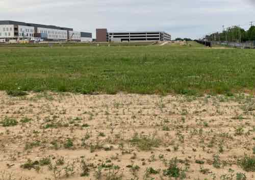
The new NGA West campus , Jefferson & Cass, has been under construction for a few years now.
Next NGA West is a large-scale construction project that will build a new facility for the National Geospatial-Intelligence Agency in St. Louis, Missouri.
This $1.7B project is managed by the U.S. Army Corps of Engineers and executed by McCarthy HITT Joint Venture, with oversight by NGA and the U.S. Air Force. The 97-acre project site is located in the historic St. Louis Place neighborhood at the intersection of Jefferson and Cass avenues.
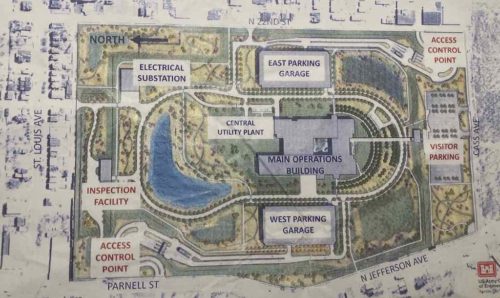
When complete, the campus will include a 700,000-square-foot office building, two parking garages, a visitor center, a delivery inspection facility and secure entrance/exit points. The staff of 3,150 will move from their current Soulard, St. Louis, location to the Next NGA West in 2026.
The primary structures on the site (main, two parking garages, visitors center) are now clearly visible from outside the perimeter. For security reasons the main building is in the very center of the site, far away from the fence on each side. This is a military facility with security you’d expect at any military base.
The new NGA West campus, opening in 2026, is neatly a 100 acre site. May 2023 image
One of the four remaining contracts on this project is for landscaping, here’s the summary:
More than $10,000,000 — Anticipated award Fall 2023
As one of the set-aside projects to the large NGA N2W design-build (D-B) project, this design-bid-build (D-B-B) project will provide site-wide landscaping, including site plantings, site furnishings, landscape lighting, and irrigation. There is no demarcation zone established for landscaping as it encompasses the entire site. The main D-B contractor will provide a master plan and concept landscape design; this project will use this information to develop the planting, irrigation, landscape lighting, and site furnishings design for procurement and installation.
The official site plans calls for extensive landscaping, mostly natives.
Don’t expect this to look like a Chesterfield office park, there won’t be large swaths of perfectly manicured turf grass with stripes. Thankfully they’re going for a more sustainable landscape, with natives instead of useless turf grass.
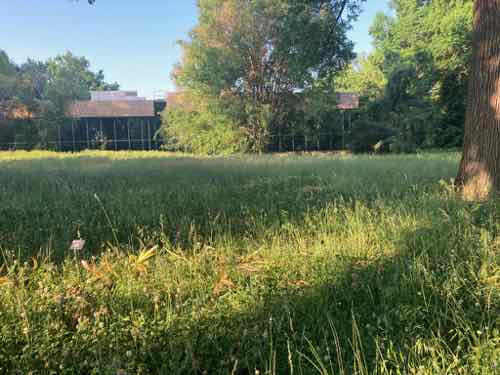
An example of an “all natural lawn” at the Missouri Botanical Garden, May 2023 This saves of water, fertilizer, mowing while creating habitat for pollinators and beneficial insects.
The NGA site plan includes a walking path around the main building, so the landscape should create a nice environment for NGA’s employees. It should also attract pollinators while not making the urban heat island effect any worse — perhaps even reducing.
The security fence is set back from the three adjacent roads (Cass, Jefferson/Parnell, and 22nd Street) so there will street trees, tree lawns and such. Plus the corner of Jefferson & Cass includes a small green space outside the secured area. Hopefully these areas along streets won’t be filled with turf grass due to its high maintenance.
Landscape maintenance will be one of many future service contracts at NGA West. Unfortunately, most/all of our existing landscape maintenance firms are set up for large areas of turf grass, edged & mowed with noisy high pollution equipment.
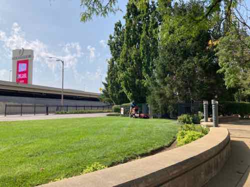
In the center you can see a worker on a noisy & polluting stand behind commercial mower. This useless high-maintenance turf grass is at the NE corner of Robert Baer Plaza, 4th & Cass. July 2023 This is an ideal spot for a low height natural lawn.
Experts say lawn and garden equipment represents about 85% of all SOREs [small off road engines] in operation today nationally, and those engines are typically manufactured without the pollution controls used on cars.
Virtually all small engines are two-stroke, which burn a dirtier fuel mix than vehicles do. Advocates say that in addition to the climate-changing emissions released by the engines, workers are exposed directly to their exhaust and rarely wear filters to protect their lungs.
Other people complain about the noise they make, especially when so many suburban residents now work from home.
I personally love the idea of banning gas lawn equipment, but it would be nice to see professional landscape maintenance companies move in that direction voluntarily. I can see a firm that uses all electric equipment (including electric trucks) getting the lucrative maintenance contract ar NGA West. Better for NGA’s employees and those doing the actual landscape maintenance work!
Interested? One place to start:
Our mission is to transition landscape maintenance to low noise, zero emissions practices with positive solutions to protect the health of workers, children, the public, and the environment. We provide research, education, outreach, and solutions, working collaboratively with communities, businesses, schools, and government agencies.
Manicured turf grass lawns are great in few places, such as ballfields. Otherwise, not so much. Traditional lawn care equipment is very noisy — every week at our apartment you’ve got the edger, mower, and leaf blower. It’s expensive, dirty, and noisy.
— Steve ———————————————————————— St. Louis urban planning, policy, and politics @ UrbanReviewSTL since October 31, 2004. For additional content please consider following on Facebook, Instagram, Mastodon, Threads, Bluesky, and/or X (Twitter).
August 19, 2023Books, FeaturedComments Off on Four Recent Books From Island Press
Book publisher Island Press always impresses me with thoughtful new books written by people working to solve current problems — the subjects are important ones for urbanists and policy makers to be familiar and actively discussing. These four books are presented in the order I received them.
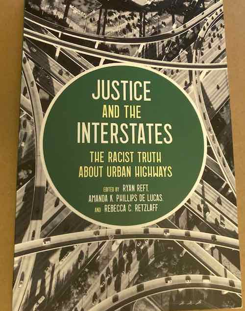
‘Justice and the Interstates: The Racist Truth About Urban Highways’ edited by Ryan Reft, Amanda K. Phillips De Lucas, and Rebecca C. Retzlaff
When the U.S. interstate system was constructed, spurred by the Federal Aid Highway Act of 1956, many highways were purposefully routed through Black, Brown, and poor communities. These neighborhoods were destroyed, isolated from the rest of the city, or left to deteriorate over time.
Edited by Ryan Reft, Amanda Phillips de Lucas, and Rebecca Retzlaff, Justice and the Interstates examines the toll that the construction of the U.S. Interstate Highway System has taken on vulnerable communities over the past seven decades, details efforts to restore these often- segregated communities, and makes recommendations for moving forward. It opens up new areas for historical inquiry, while also calling on engineers, urban planners, transportation professionals, and policymakers to account for the legacies of their practices.
The chapters, written by diverse experts and thought leaders, look at different topics related to justice and the highway system, including: • A history of how White supremacists used interstate highway routing in Alabama to disrupt the civil rights movement • The impact of the highway in the Bronzeville area of Milwaukee • How the East Los Angeles Interchange disrupted Eastside communities and displaced countless Latino households • Efforts to restore the Rondo neighborhood of St. Paul
Justice and the Interstates provides a concise but in-depth examination of the damages wrought by highway construction on the nation’s communities of color. Community advocates, transportation planners, engineers, historians, and policymakers will find a way forward to both address this history and reconcile it with current practices.
Eisenhower’s original vision for interstate highways connecting different metropolitan areas didn’t include them slicing through and dividing urban centers, but racist white civil engineers born in the 19th century, like Harland Bartholomew in St. Louis and Robert Moses in New York, were able to successfully lobby for them to tear right through cities so they’d have access to hundreds of millions of dollars “renew” old cities. But renewal meant destruction of everything in sight, making life easier for suburbanites crowding streets with their cars, destroying thriving minority neighborhoods along the way. Cities like St. Louis are still suffering from their decisions, the interstates still divide.
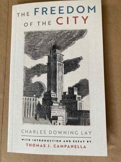
‘The Freedom of the City’ by Charles Downing Lay
“Congestion is the life of the city . . . it is what we came for, what we stay for, what we hunger for”, wrote Charles Downing Lay, prominent American landscape architect and planner of the early 1920s. These words are relevant today as density and congestion are once again under siege, especially in our most productive and thriving cities.
Published in 1926, The Freedom of the City by Charles Downing Lay is an eloquent and timely defense of urbanism and city life. Award-winning author and urban historian Thomas J. Campanella has given Lay’s text new life and relevance, with the addition of explanatory notes, imagery, an introduction, and biographical essay, to bring this important work to a new generation of urbanists.
Lay was decades ahead of his time, writing The Freedom of the City as Americans were just beginning to fall in love with the automobile and leave town for a romanticized life on the suburban fringe. Planners and theorists were arguing that heavily congested cities were a form of cancer, that great metropolitan centers like London and New York City must be decanted into a leafy “garden cities” in the countryside. Lay saved his sharpest pen for these anti-urbanists in his own profession of city and regional planning.
Lay writes of the delights of city life and—especially—that importance of the singular, essential ingredient that makes it all possible: “congestion” (closest in definition to “density” today). Congestion, to Lay, is the secret sauce of cities, the singular element that gives London, Paris, or New York its dynamism and magic. He believed that the amenities and affordances of a city are “the direct result of its great congestion”; indeed, congestion is “the life of the city. Reduce it below a certain point and much of our ease and convenience disappears.
Campanella writes “for all his blind spots, Lay’s core argument still obtains. The Freedom of the City was prescient in 1926 and timely now. Certainly, the essentials of good urbanism extolled in the book—human scale, diversity, walkability, the serendipities of the street; above all, density—are articles of faith among architects and urbanists today.”
I’d never heard of Charles Downing Lay before receiving this book, it’s nice to know at least one white male born in the 19th century was writing about the wonderful qualities of life in the city.
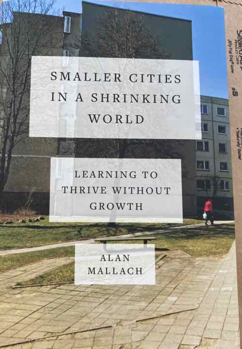
‘Smaller Cities in a Shrinking World: Learning to Thrive Without Growth’ by Alan Mallach
Over the past hundred years, the global motto has been “more, more, more” in terms of growth – of population, of the built environment, of human and financial capital, and of all manner of worldly goods. This was the reality as the world population boomed during the 1960s and 1970s. But reality is changing in front of our eyes. Growth is already slowing down, and according to the most sophisticated demographers, the earth’s population will begin to decline not hundreds of years from now, but within the lifetimes of many of the people now living on the planet.
In Smaller Cities in a Shrinking World, urban policy expert Alan Mallach seeks to understand how declining population and economic growth, coupled with the other forces that will influence their fates, particularly climate change, will affect the world’s cities over the coming decades. What will it mean to have a world full of shrinking cities? Does it mean that they are doomed to decline in more ways than simply population numbers, or can we uncouple population decline from economic decay, abandoned buildings and impoverishment?
Mallach has spent much of the last thirty or more years working in, looking at, thinking, and writing about shrinking cities—from Trenton, New Jersey, where he was director of housing and economic development, to other American cities like Detroit, Flint, and St. Louis, and from there to cities in Japan and Central and Eastern Europe. He has woven together his experience, research, and analysis in this fascinating, realistic yet hopeful look at how smaller, shrinking cities can thrive, despite the daunting challenges they face.
Shrinking cities, declining population, etc it’s no wonder St. Louis city is included — but the entire St. Louis metropolitan area on both sides of the Mississippi River is a low/no growth area. We need to stop thinking problems only exist within the 1876 border of the namesake city, we need to figure out how to get our entire region to thrive without growth from new population. Sorry, new residents in Wentzville that move from St. Charles or north/west St. Louis County isn’t growth — at least not on the regional level.
‘Inclusive Transportation: A Manifesto for Repairing Divided Communities’ by Veronica O. Davis
Transportation planners, engineers, and policymakers in the US face the monumental task of righting the wrongs of their predecessors while charting the course for the next generation. This task requires empathy while pushing against forces in the industry that are resistant to change. How do you change a system that was never designed to be equitable? How do you change a system that continues to divide communities and cede to the automobile?
In Inclusive Transportation: A Manifesto for Repairing Divided Communities, transportation expert Veronica O. Davis shines a light on the inequitable and often destructive practice of transportation planning and engineering. She calls for new thinking and more diverse leadership to create transportation networks that connect people to jobs, education, opportunities, and to each other.
Inclusive Transportation is a vision for change and a new era of transportation planning. Davis explains why centering people in transportation decisions requires a great shift in how transportation planners and engineers are trained, how they communicate, the kind of data they collect, and how they work as professional teams. She examines what “equity” means for a transportation project, which is central to changing how we approach and solve problems to create something safer, better, and more useful for all people.
Davis aims to disrupt the status quo of the transportation industry. She urges transportation professionals to reflect on past injustices and elevate current practice to do the hard work that results in more than an idea and a catchphrase.
Inclusive Transportation is a call to action and a practical approach to reconnecting and shaping communities based on principles of justice and equity.
As we think about light rail expansion in the city & north county it’s an opportunity to put this manifesto into practice.
— Steve ———————————————————————— St. Louis urban planning, policy, and politics @ UrbanReviewSTL since October 31, 2004. For additional content please consider following on Facebook, Instagram, Mastodon, Threads, Bluesky, and/or X (Twitter).
August 17, 2023Central West End, FeaturedComments Off on New Siteman Cancer Center, Update on my Cancer
This post is about two indirectly related topics: the new Siteman Cancer Center building under construction on the Washington University School of Medicine/BJC campus and an update on my stage 4 kidney cancer.
Let’s deal with the latter first. You may have noticed I’ve not posted in three months, this is not due to a lack of topics, interest, photographs, etc. In April my routine CT/Bone scans showed that my cancer was progressing — tumors (yes, plural) were growing again. At that time I’d been on my 2nd line of treatment for 21 months, my 1st line of treatment lasted 18 months.
After a 2 week delay to select the next treatment, get insurance approval, and secure more grants for the huge monthly co-payments I began my 3rd line of treatment. Instead of the previous infusion of drug a every 4 weeks plus a daily pill I now take 3 pills daily (2 medications). For 12 weeks since my previous scans I had no idea if these two new medications were working, or not. Twelve weeks is a very long time to wait when you don’t know if medication is working. But I recently got the good news – my recent scans showed my tumors as “stable.” During that 3 month uncertain period I was in a bit of a funk. I’m in a better mindset now, ready to get back at it.
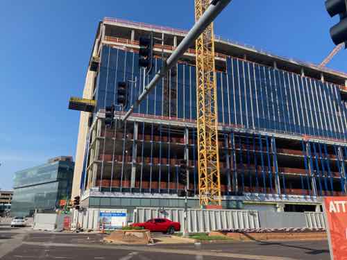
The new Siteman under construction on the southwest corner of Forest Park and S. Taylor Ave, July 2023
For 45 months now I’ve been a patient at Siteman Cancer Center, 7th floor of the Center for Advanced Medicine on the southwest corner of Forest Park and S. Euclid –one block west of the new building under construction. It’s clearly more crowded than intended — one treatment pod for 6 patients was originally the employee breakroom!
So when WashU/BJC announced in July 2021 plans for a new building it was very exciting. I just wasn’t certain I’d live to see it.
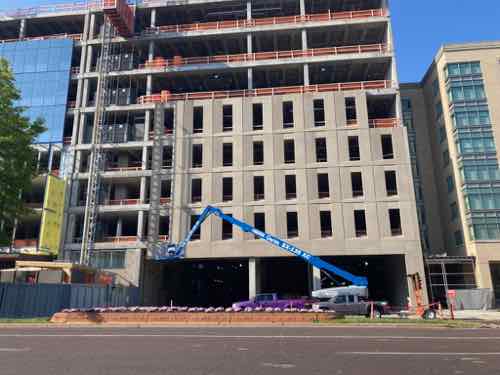
The new Siteman is on top of numerous floors of parking.
By including parking in the building it’ll make visits easier for patients and their family — the current journey from parking in the Euclid Garage to the Center for Advanced Medicine (CAM) is long. In addition to Siteman on 7 patients routinely visit radiology on 2 & 3. It’ll be nice having everything in a more compact footprint.
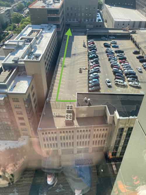
Looking east from the current Siteman, with the Euclid Garage in the center and the new Siteman in the upper left.
The new Siteman building will be connected to the rest of the Washington University Medical School/BJC campus via the interior elevated walkway system — aka The Link. The green arrow in the photo above shows where the walkway will go along the top level of the Euclid Garage, along the north side.
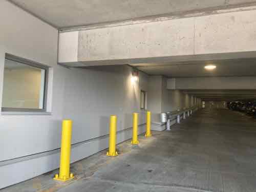
Here’s an example of such an enclosed walkway built within an existing parking garage, elsewhere on the campus.
The new building is supposed to open next summer, so I’m fairly optimistic at this point I’ll still be around for lab work, radiology, and doctor visits.
— Steve ———————————————————————— St. Louis urban planning, policy, and politics @ UrbanReviewSTL since October 31, 2004. For additional content please consider following on Facebook, Instagram, Mastodon, Threads, Bluesky, and/or X (Twitter).
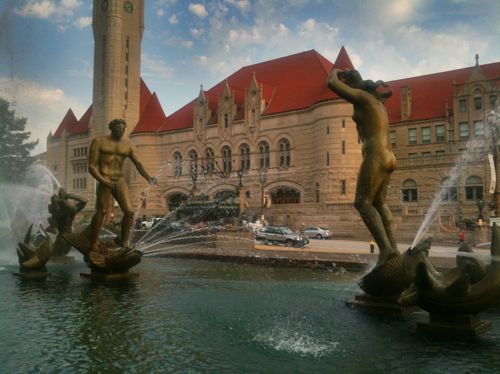
Eighty-three years ago today a new urban plaza was opened across Market Street from Union Station. The decennial census taken the previous month would later show the city’s population had declined slightly.
Carl Milles’ ‘Meeting of the Waters’ is the focal point of Aloe Plaza. 2011
St. Louisans of the 1930s removed the buildings, businesses, and activity from across Union Station. It was what people first saw upon arrival, they wanted beauty instead of what they viewed as clutter and illicit activity. Passive over bustling. They were successful…too successful.
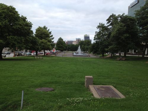
Looking west across Aloe Plaza, from 18th Street in 2013
For a good 70 years the west end of Aloe Plaza is what motorists saw as they exited the highway, ending up at 20th & Chestnut. Now with CITYPARK, our new MLS stadium replacing the on/off ramps, the situation west of Aloe Plaza is entirely different.
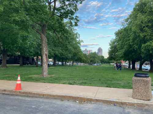
Looking east from 20th Street atAloe Plaza, just as STL CITY SC began hosting the Portland Timbers on April 29 2023.
20th Street is closed for a block party before matches, porta-potties are lined up nearby. To the west is the start of the Brickline Greenway, a 2-way cycle track plus a wide pedestrian path. This needs to continue east and the two blocks of Aloe Plaza are next.
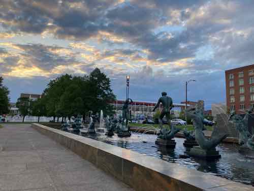
The space has some very large old trees. I’m not an arborist so I can’t say they’re worth keeping, or not. The ’Meeting of the Waters’ fountain by Carl Milles is certainly sacred, though in desperate need of a new basin.
Meeting of the Waters with CITYPARK stadium in the background, just as STL CITY SC began hosting the Portland Timbers on April 29 2023.
I’d love to see something happen (charrette, competition, etc) to gather ideas on how to turn this passive two-block long public park into an exciting new public space that includes the fountain in the same or different place. Does the fountain need to be centered on Union Station? Must it be parallel to Market Street? Among many questions we should ask ourselves.
One thing I see as a must-have amenity is a public restroom. The entire region needs these where we expect tourists, people cycling/walking, and such. Not inside a nearby business — a highly visible kiosk structure that opens directly to the sidewalk. These can be self-cleaning, the ones I used in San Francisco last fall were wonderful.
I can also imagine a structure(s) for food, beverage, events, and such.
I’m not sure about the name Aloe Plaza. It made sense in 1940 as the former president of the board of aldermen, Louis B. Aloe, had died just over a decade before. Aloe was instrumental in a 1923 bond issue — a century ago. Aloe, the bond issue, the businesses displaced, etc should all be represented in the new space. I’m just not sure the name for the last 83 years should carry forward.
The entire two block park bounded by Market, 18th, Chestnut, and 20th needs to be rethought, reimagined for the 21st century.
— Steve ———————————————————————— St. Louis urban planning, policy, and politics @ UrbanReviewSTL since October 31, 2004. For additional content please consider following on Facebook, Instagram, Mastodon, Threads, Bluesky, and/or X (Twitter).
AARP Livibility Index
The Livability Index scores neighborhoods and communities across the U.S. for the services and amenities that impact your life the most
Built St. Louis
historic architecture of St. Louis, Missouri – mourning the losses, celebrating the survivors.
Geo St. Louis
a guide to geospatial data about the City of St. Louis