Home » History/Preservation » Recent Articles:

St. Louis Central Library Opened 100 Years Ago Today

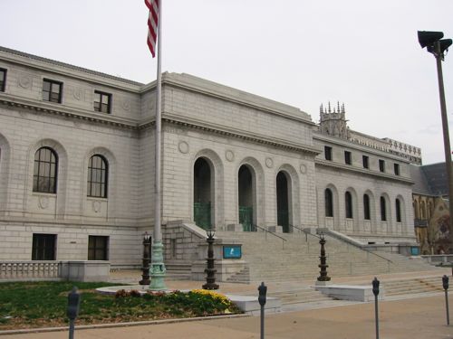
Saturday January 6, 1912 a new library opened for the citizens of St. Louis. The St. Louis Library was started in 1865 and was located in various buildings until this structure opened a century ago.

ABOVE: South facade of the Central Library before renovation work started

The site contained a building, less than 30 years old, that was razed for the library:

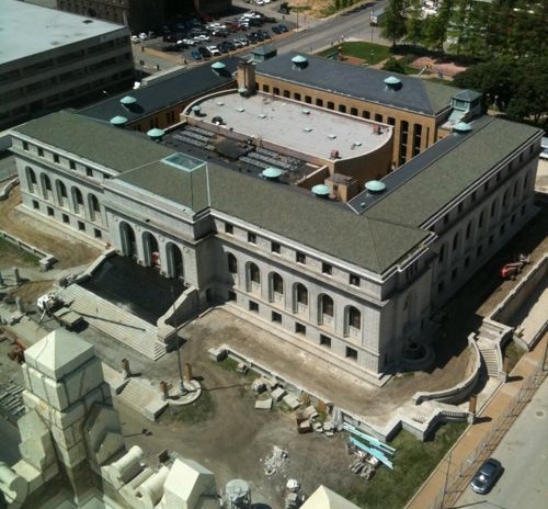
The Central Library building at 13th and Olive was built in 1912 on a location formerly occupied by the St. Louis Exposition and Music Hall and was designed by Cass Gilbert. The main library for the city’s public library system has an oval central pavilion surrounded by four light courts. The outer facades of the free-standing building are of lightly rusticated Maine granite. The Olive Street front is disposed like a colossal arcade, with contrasting marble bas-relief panels. A projecting three-bay central block, like a pared-down triumphal arch, provides a monumental entrance. At the rear, the Central Library faces a sunken garden. The interiors feature some light-transmitting glass floors. The ceiling of the Periodicals Room is modified from Michelangelo’s ceiling in the Laurentian Library. Renovation and expansion of the building began in 2010 and is scheduled to finish in 2012 (Wikipedia)

The library is a complex building as described above and as seen below.

ABOVE: Central Library as viewed from the roof of the Park Pacific, May 2011

The library closed in mid-2010 to undergo an extensive top to bottom renovation (see Beacon story w/video). The library will reopen later this year, most likely in the fall.They’ve put together a great website on the history of the building and the renovation plans, click here to view (highly recommended).

Prior to the closure the administrative offices moved to a newer building across 14th Street, freeing up more space for public use.

ABOVE: Library administration is now housed in this building at 14th & Olive

I live two blocks west of the library, I can’t wait for it to reopen.

– Steve Patterson


1721 Hadley Street

The week between Christmas and New Year’s is always slow so I fill the days with odd little posts.

ABOVE: 1721 Hadley Street on December 22, 2011 (click for map)

Last week driving around I spotted this gem. The detailing on the front porch, the proportions and the cute side entry caused me to stop the  car to get this picture. 1721 Hadley Street is a 1,714 sq foot house built in 1890. It’s owned by a couple on 13th Street. The main roof and back roof have both collapsed so this structure won’t be around long.

It faces the south end of the proposed Iron Horse Trestle:

The Trestle is an 1.5 mile abandoned railroad alignment purchased by Great Rivers Greenway. It is the same railroad alignment that connects from the McKinley Bridge to Branch Street and was renovated in 2007 as part of the McKinley Bridge Bikeway.

The Trestle project begins at Branch Street where it will connect with the Riverfront Trail and the existing McKinley Bridge Bikeway. The Trestle is elevated above North Market Street adjacent to Produce Row, the City’s fruit and vegetable wholesale district and continues as it crosses over Interstate 70. Offering views of downtown St. Louis, the Mississippi River and the adjacent neighborhoods. The Trestle touches down near the intersection of Howard and Hadley Avenues just north of the new Mississippi River Bridge.

Status:

Great Rivers Greenway purchased the Trestle in 2005 and in 2007 initiated work to develop a conceptual plan for developing the trestle into a linear public park and greenway. Over the past several years, detailed engineering plans have been prepared in anticipation of construction.

In 2010, Great Rivers Greenway hired a construction management firm to work with the design team to recommend strategies to construct the project in phases as well as identify construction methods for renovating the elevated deck. It was identified that the Trestle could be constructed in two phases and Great Rivers Greenway is determining the best strategy to move towards construction in the next several years.

In mid 2011, Great Rivers Greenway began work to develop plans to paint the portion of the Trestle over Interstate 70. The painting will occur in the 2013 or 2014 as permits are secured from the Missouri Department of Transportation. 

1721 Hadley Street is zoned industrial, not residential.

– Steve Patterson

b


Approaching the MacArthur Bridge (Updated)

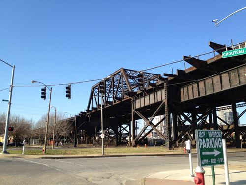
One of the differences I see between urbanists and suburbanites is the love of old vs new, respectively. Urbanists see beauty in old, even decaying, structures whereas others feel more comfortable around new everything. Take the Missouri approach to the MacArthur Bridge over the Mississippi River as an example.

ABOVE: Missouri approach to the MacArthur Bridge as seen from 4th & Chouteau

I love the rusting steel structure.

The MacArthur Bridge over the Mississippi River between St. Louis, Missouri and East St. Louis, Illinois is a 647 foot (197 m) long truss bridge. Construction on the bridge was begun in 1909 by the city of St. Louis to break the Terminal Railroad Association of St. Louis’s monopoly on the area’s railroad traffic. Money ran out before the bridge approaches could be finished, however, and the bridge did not open until 1917, and then only to automobile traffic. Railroad traffic would not use the bridge’s lower deck until 1928. The bridge was initially called the “St. Louis Municipal Bridge” and known popularly as the “Free Bridge.” Tolls were added for auto traffic beginning in 1932. In 1942 the bridge was renamed for Douglas MacArthur. The MacArthur Bridge was one of several bridges in St. Louis which carried U.S. Highway 66 until the completion of the nearby Poplar Street Bridge. At one time U.S. Highway 460 crossed the bridge, terminating on the west side of the bridge. In 1981 the bridge was closed to vehicles because of pavement deterioration and the western ramp approaches were torn out. The bridge is now in use only by railroads.  (Wikipedia)

Sure I love the bridge itself but the approach is…well, approachable. I’m sure most suburbanites don’t see the beauty I see. To them it is an eyesore that should be removed or replaced.

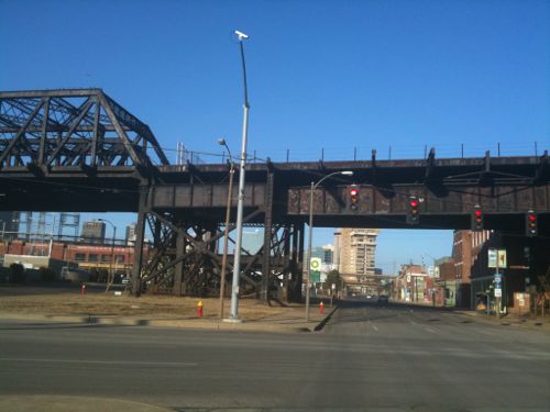
ABOVE: Missouri approach to the MacArthur Bridge as seen from NB 4th at Chouteau

I’ve crossed this bridge once on Amtrak but I prefer seeing the structure from the area around 4th Street & Chouteau. When I’m driving in the area I hope for red lights just to be able to look at the structure longer. When I’m on the bus I get to look at it without worrying about being distracted.

Do you see what I see? Or do you just see rusted steel?

UPDATE:

I need to clarify my suburbanite vs urbanite thesis. Many urban dwellers have rejected New Urbanism because of it’s newness even though it is otherwise well designed and compact. Similarly “newness” is always included a criteria in suburban preference studies. One study in California looking at residents of traditional neighborhoods & suburban neighborhoods found: “Residents in suburban neighborhoods have a higher average score for the safety factor, and among the individual attributes, their average ratings are particularly higher for cul-de-sacs, newness, school quality, parking, and quiet.“ (emphasis added). I’ll dig into all the  large amount of literature and do a followup post.

 – Steve Patterson


Urbanists & Preservationists Will Support Pevely Dairy Today

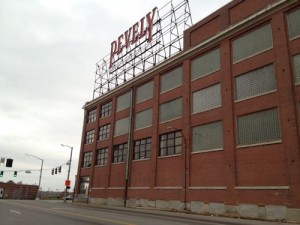
ABOVE: The historic Pevely Dairy maintains the building line at both Grand & Chouteau. Click image for my post from last month

The Preservation Board usually meets on the 4th Monday of each month but due to the holidays will instead meet tonight. On the agenda is Saint Louis University’s proposal to replace the historic structures with a lawn. And probably a fountain.

The conclusion of the staff report (see agenda):

The proposed subsequent construction of the Ambulatory Care Center cannot be evaluated at the time these comments were prepared and needs to be considered once presented at the Preservation Board meeting. The Cultural Resources Office recommends that the Preservation Board approve the demolition of the milk plant at 3626‐80 Chouteau and the garage at 1101 Motard, as the loss of these Merit buildings would have an acceptable effect on the urban design and the streetscape. The Cultural Resources Office also recommends that the Preservation Board uphold the denial of the demolition of the office building as it is a sound, High Merit resource and has reuse potential, and the iconic smokestack. These two structures on the parcel with the address 1001‐03 S. Grand, are prominent in the streetscape and their loss would have a noticeable effect on the physical fabric of the neighborhood and urban design.

Many have expressed the viewpoint the corner structure and smokestack occupy a tiny portion of the total site and therefor do not impede plans for new construction on the rest of the site. I’d love to see a drawing with Saint Louis University’s proposed building superimposed over the corner structure and smokestack.

– Steve Patterson


New Madrid Earthquake Two Centuries Ago

Two hundred years ago today the first of a series of three earthquakes hit near the Missouri town of New Madrid:

This sequence of three very large earthquakes is usually referred to as the New Madrid earthquakes, after the Missouri town that was the largest settlement on the Mississippi River between St. Louis, Missouri and Natchez, Mississippi. On the basis of the large area of damage (600,000 square kilometers), the widespread area of perceptibility (5,000,000 square kilometers), and the complex physiographic changes that occurred, the New Madrid earthquakes of 1811-1812 rank as some of the largest in the United States since its settlement by Europeans. They were by far the largest east of the Rocky Mountains in the U.S. and Canada. The area of strong shaking associated with these shocks is two to three times as large as that of the 1964 Alaska earthquake and 10 times as large as that of the 1906 San Francisco earthquake. Because there were no seismographs in North America at that time, and very few people in the New Madrid region, the estimated magnitudes of this series of earthquakes vary considerably and depend on modern researchers’ interpretations of journals, newspaper reports, and other accounts of the ground shaking and damage. The magnitudes of the three principal earthquakes of 1811-1812 described below are the preferred values taken from research involved with producing the 2008 USGS National Seismic Hazard Map .

The first principal earthquake, M7.7, occurred at about 2:15 am (local time) in northeast Arkansas on December 16, 1811. The second principal shock, M7.5, occurred in Missouri on January 23, 1812, and the third, M7.7, on February 7, 1812, along the Reelfoot fault in Missouri and Tennessee. The earthquake ground shaking was not limited to these principal main shocks, as there is evidence for a fairly robust aftershock sequence. The first and largest aftershock occurred on December 16, 1811 at about 7:15 am. At least three other large aftershocks are inferred from historical accounts on December 16 and 17. These three events are believed to range between M6.0 and 6.5 in size and to be located in Arkansas and Missouri. This would make a total of seven earthquakes of magnitude M6.0-7.7 occurring in the period December 16, 1811 through February 7, 1812. In total, Otto Nuttli reported more than 200 moderate to large aftershocks in the New Madrid region between December 16, 1811, and March 15, 1812: ten of these were greater than about 6.0; about one hundred were between M5.0 and 5.9; and eighty-nine were in the magnitude 4 range. Nuttli also noted that about eighteen hundred earthquakes of about M3.0 to 4.0 during the same period. 

The first earthquake of December 16, 1811 caused only slight damage to man-made structures, mainly because of the sparse population in the epicentral area. The extent of the area that experienced damaging earth motion, which produced Modified Mercalli Intensity greater than or equal to VII, is estimated to be 600,000 square kilometers. However, shaking strong enough to alarm the general population (intensity greater than or equal to V) occurred over an area of 2.5 million square kilometers.

The earthquakes caused the ground to rise and fall – bending the trees until their branches intertwined and opening deep cracks in the ground. Deep seated landslides occurred along the steeper bluffs and hillslides; large areas of land were uplifted permanently; and still larger areas sank and were covered with water that erupted through fissures or craterlets. Huge waves on the Mississippi River overwhelmed many boats and washed others high onto the shore. High banks caved and collapsed into the river; sand bars and points of islands gave way; whole islands disappeared. Surface fault rupturing from these earthquakes has not been detected and was not reported, however. The region most seriously affected was characterized by raised or sunken lands, fissures, sinks, sand blows, and large landslides that covered an area of 78,000 – 129,000 square kilometers, extending from Cairo, Illinois, to Memphis, Tennessee, and from Crowley’s Ridge in northeastern Arkansas to Chickasaw Bluffs, Tennessee. Only one life was lost in falling buildings at New Madrid, but chimneys were toppled and log cabins were thrown down as far distant as Cincinnati, Ohio, St. Louis, Missouri, and in many places in Kentucky, Missouri, and Tennessee.

The Lake County uplift, about 50 kilometers long and 23 kilometers wide, stands above the surrounding Mississippi River Valley by as much as 10 meters in parts of southwest Kentucky, southeast Missouri, and northwest Tennessee. The uplift apparently resulted from vertical movement along several, ancient, subsurface faults. Most of the uplift occurred during prehistoric earthquakes. A strong correlation exists between modern seismicity and the uplift, indicating that stresses that produced the uplift may still exist today. (USGS)

Many have been saying for years a big one is coming again.

ABOVE: Earthquake strengthening under I-64/Hwy 40, click image for more info

MoDOT began strengthening the double-deck portion of I-64/Hwy 40 in August 2006 and the work continues. Will we have the big one? I don’t know, my family & friends in Oklahoma didn’t think they’d feel an earthquake there but they did last month. I probably should put together an earthquake preparedness kit.
– Steve Patterson


Advertisement


[custom-facebook-feed]

Archives

Categories

Advertisement


Subscribe