Home » History/Preservation » Recent Articles:

St. Louis’ official flag designed by a Yale professor in early 1960s (updated)

February 12, 2010 History/Preservation 15 Comments

To my eye the official flag of the City of St. Louis is quite striking, the colors and composition are excellent.

The St. Louis flag for the last 50 years
The St. Louis flag for the last 46 years, click for Wikipedia article

In looking at the flag recently, I began to wonder about its history.  A number of websites listed the same information, from the same source.  So I went directly to that source: The Revised Code of the City of St. Louis:

“1.20.010 Description.

The design submitted by Professor Emeritus Theodore Sizer, Pursuivant of Arms at Yale University, and now on file in the office of the City register is approved, adopted and designated as the official flag of the City. The flag with a solid red background has two broad heraldic wavy bars, colored blue and white, extending from the left top and bottom corners toward left center where they join and continue as one to the center right edge. This symbolizes the confluence of the Missouri and Mississippi rivers. Over the point of confluence a round golden disk upon which is the fleur-de-lis of France (blue) calling attention to the French background of the early city and more particularly to St. Louis of France for whom the City is named. The golden disk represents the City and/or the Louisiana Purchase. (Heraldically, the disk is a “bezant” or Byzantine coin signifying, money or simply purchase.)

The flag’s colors recall those of Spain (red and yellow or gold), Bourbon France (white and gold), Napoleonic and Republican France (blue, white and red), and the United States of America (red, white, and blue). (Ord. 52322 § 2, 1964: 1948 C. Ch. 1 § 5: 1960 C. § 6.020.)”  (1.20.010)

I had long assumed the flag was from the 19th century but the years listed above include 1948, 1960 and 1964.  Unsure of the meaning of these I turned to David Sweeney, Clerk at the Board of Aldermen. He pulled two ordinances that further clarify the history.

First is the ordinance (#52322) that denotes the current flag as the official flag, approved on February 3, 1964:
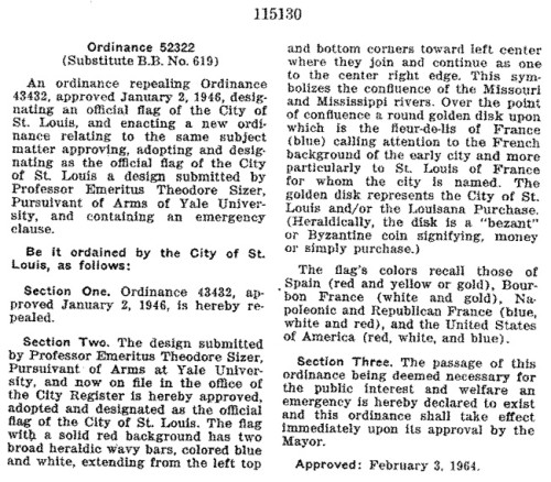
Ord52322

It repealed an earlier ordinance that was approved on January 2, 1946 that made a 1916 flag official – 30 years after the fact:
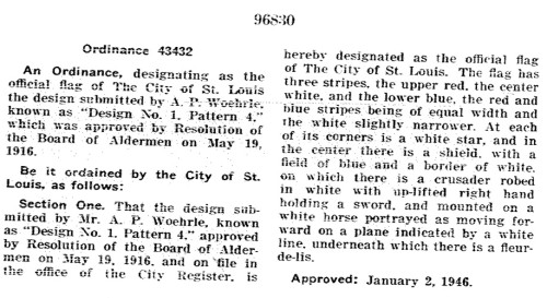
Ord43432

I’d like to see a picture of this 1916-1964 flag.  What is still not yet known is if St. Louis had flag prior to 1916.  The creator of our current flag, Theodore Sizer, was born in 1892 and he died 75 years later in 1967.  He was an art history professor at Yale.  My guess is a competition was held for the design.  Flags don’t seem to be the important symbols they once were.

UPDATE: 2/13/2010 @ 10:00AM:

Thank you to Michael Allen (Ecology of Absence) and Daniel Glossenger (Bygone St. Louis) for looking up additional information on the 1916 flag.  In the January 25, 1916 edition of the St. Louis Post-Dispatch it was announced that Edward A. Krondl won a $100 prize for his entry.

ABOVE: Winning design from January 1916. Image from Post-Dispatch

Krondl was a 27 year old unmarried commercial artist living in a 4-family located at 2317 Indiana Avenue.  More than 200 entries were submitted. But the Pageant Drama Association that organized the competition felt the blue was not blue enough and the orange not orange enough.

On May 20, 1916 the Post-Dispatch published the winner of a new competition:
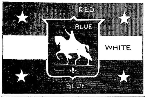
ABOVE: Winning design from May 1916. This was our official flag until 1964. Image from Post-Dispatch

The winner of the $100 prize this time was A. P. Woehrle of 3214 Gustine Avenue.  But it was disclosed the winner was actually Edward Krondl, the winner from earlier in the year.  Krondl submitted his new design using the name of a friend because he “wanted to win on merit and not the prestige gained by winning the previous contest.”   The Board of Aldermen passed a resolution to adopt this latest entry as the official flag — the first for the city from what I can gather.  Here was the best line, “Alderman Fett asked to be excused from voting, on the grounds he was too patriotic to vote for for any flag except the stars and stripes.”

– Steve Patterson


City Hospital once part of a dense neighborhood

Cities, and the neighborhoods within them, slowly change over time.  Old photographs and written accounts are our best window into life before we existed.  When I arrived in St. Louis in August 1990 the old City Hospital complex on Lafayette was long vacant.  Now the main building is The Georgian condos but two other structures were razed for the condo project.

From Paul Hohman of Vanishing St. Louis:

The aerial photo below from 2002 shows the City Hospital site as a fairly dense urban village with the old Administration Building along Lafayette, the 13 story Tower Building at center fronting on Carrol Street (notice how Carrol connects to the residential area to the west), and the 6 story former Malcolm Bliss Mental Heath Center along Park Avenue. In late 2002 demolition began on Malcolm Bliss and the Tower Building prior to the conversion of the Administration Building into the Georgian Condominiums by Gilded Age.

Image source: Vanishing STL, click image for post

Last year I brought the following photo which shows the construction of the now-razed tower building.

Source: scanned original photo

This was an era of increased building possible through rail transit (streetcars).  I know perceptions were changing anyway, but I can’t help but think the demise of the last streetcar in 1966 contributed to further decline.  Eight lines were closed in 1946/47.  Cities like New Orleans, San Francisco and Toronto kept their lines running and that has paid dividends for them.

– Steve Patterson


Changes to the St. Louis Board of Aldermen in my lifetime, future change proposed

ABOVE: 1967 St. Louis ward map
ABOVE: 1967 St. Louis ward map. Source: We Elect! book from the Buckowitz archives

Every ten years, following each national census, the boundaries of St. Louis’ 28 wards are redrawn. The map above is based on the 1960 census.   UPDATE 2/8/2010 4:25PM:  the map above reflects changes following a 1965 lawsuit that challenged the way the maps were drawn. Prior to 1965 districts were based on the number of registered voters, not the number of residents.

The map below (rotated 90 degrees counter-clockwise) is the current map based on the 2000 census.

ABOVE: Current ward map

Most wards are still in the approximate same location while a handful are in completely different parts of the city.  The idea is for each ward to contain the same number of residents.  Areas that lose more people than others will see the physical size of the ward grow.

The ward map at the top is from a 1967 book published by the St. Louis Public schools explaining the election process: We Elect! The story of St. Louis Government and Politics.  It was published in the year I was born, 1967.  They met at 11am on Fridays wheres they meet at 10am Fridays currently, not sure when that changed.  Looking through the information in the book I decided I needed to put it in a table to see it in one place.

Some interesting things jump out at me:

  • Five new members were elected in 1967, three of which were Republicans (ward # shown in red).  One Republican is on the current board, first elected way back in 1979.
  • Eight members (29%) were Black.  Currently the board has 12 black members (43%) plus Board President Lewis Reed.
  • Only two female members (7%), both Black.  The current board has eight females (29%) split evenly between Black & White.
  • 32% (9/28) of the members had served 12 or more years.   Today 46% (13/28) have served 12 or more years.
  • Only one (4%) had served 20 years.  Today seven (25%) have served 20 or more years.
  • The average length of service was 7.5 years in 1967.  In 2010 it is 11.45 years, a 53% increase!

Elsewhere in the book the committeeman & committeewomen were listed for each ward. Every ward (except the 21st) had both Democrats & Republicans in place. We had somewhat of a two-party city in 1967.  Today we have a one party city yet we hold primary & general elections.  In one party elections holding a primary & general elections is just a huge waste of limited money.   With service cuts to reduce the city budget holding unnecessary partisan primaries is a luxury we just can’t afford.   I’d like a lawyer out there to contact me to see what it would take to switch our city elections to non-partisan.  I’d love a measure on the ballot during an an upcoming election, such as November 2010.

I know many of you are not fans of term limits but I see a need for a limit of say five terms/20 years.  Two decades is plenty of time to get into office, learn the ropes, and have an impact before passing the torch onto the next generation.

I will be on KDHX (88.1FM) tonight (Monday 2/8/2010) at 8:30pm discussing this and other local issues.

– Steve Patterson


Non-profit runs out of money, boards building

Above: Pillar Place Apartments, 3407 Lafayette Avenue
Above: Boarded Pillar Place Apartments, 3407 Lafayette Avenue

I recently received an email from a reader asking if I knew why the Pillar Place Apartment building was now boarded.   I didn’t know the name but once I looked up the address provided to me (3407 Lafayette) I knew the building.  In August 1990, when I first moved to St. Louis, the building was vacant, just waiting to be reused.  By February 1993 I was delighted the building was renovated into apartments.

From the St. Louis Post-Dispatch February 27, 1993:

“On Wednesday, they [the Brown family] became one of the first six families to move into Pillar Place, a newly renovated apartment building for 19 low-income families at 3407 Lafayette Avenue, St. Louis.
“This is one of the happiest days of my life since I moved to St. Louis,” said Brown, 29, who came here from Mississippi 11 years ago.
The 19 Roman Catholic religious orders and a nonprofit corporation that came together to make Pillar Place will celebrate with a grand opening there at 1 p.m. Sunday.
They have taken a four-story building listed on the National Register of Historic Places and converted it into two- , three- and four-bedroom apartments for people “stuck in the funnel” of temporary housing.
“We realized the real need is for permanent, affordable housing,” said Sister Mary Louise Denny, a Sister of Loretto and a board member of the Intercommunity Housing Association, which helped start the project. “This will be a drop in the bucket – we could have found 10 times the number of people who need this. But it’s a start.”
The building opened in 1907 as the Loretto Academy, a posh school for girls and a residence for the Sisters of Loretto. The school moved to Nerinx Hall in Webster Groves in the 1950s, and the retired nuns who then made the building their home moved to the suburbs in 1988.
About that time, the St. Louis Equity Fund was started. Through the fund, area companies invest in partnerships that provide low-income housing. In return, the companies can earn tax credits. The Intercommunity Housing Association – made up of 13 religious organizations – joined with the Equity Fund and six other religious groups to raise the $1.5 million needed for renovation and organization of Pillar Place.”

From the  Intercommunity Housing Association website:

“Formerly Loretto Academy high school for girls converted into 19 two, three and four bedroom apartments. Pillar Place serves about 22 adults and approximately 70 children. The complex has a large parking lot, two playground areas, a picnic area, and vegetable gardens for the tenants to use.”

Also from their website is an overview of who they are and what they do — uh, did:

“IHA is a not-for-profit organization with 501(c)3 tax exempt status.

Our support services are paid for through generous donations of individuals, families, churches and religious groups, civic organizations, corporations, foundations, and special events.

The operating expenses of our buildings including mortgage, insurance, maintenance, and repairs are partially paid for out of tenant rents which are subsidized by the U.S. Department of Housing and Urban Development. Tenants at Pillar Place and Compton Place pay rent based on their income. They also pay their own utilities. The apartments at both locations offer ample space, providing residents with feelings of comfort, dignity and self-worth they may not have experienced before.

The families of IHA have come from various backgrounds. Some come from shelters, often a family may live in one room at a shelter while they wait for an opening. Some have lived in another family member’s basement, some have lived in hallways of buildings, some have lived in their car. Some of our families are immigrants who have fled oppression and abuse. Others are referred from agencies and organizations in the area. All must meet our guidelines for admission, including police checks and credit checks. A home visit prior to their admission is required for all tenants before acceptance.

Intercommunity Housing Association’s staff, board members and volunteers are constantly working to provide for the 33 families and over 100 children in need. However, they cannot do this alone. Individual and corporate donations are the driving force behind our success. The programs offered make a significant impact on their lives by bringing security and stability. This is accomplished by moving beyond the fundamental needs of a roof over their heads. IHA supplies our residents with the tools necessary to help improve their life circumstances and move them to independence.

History of IHA and What we offer

IHA was created through the collaboration of 19 religious congregations of women who saw the need to provide more than affordable housing for the poor of St. Louis. They saw the need to help the families that came to live at the two apartment complexes to become independent through social, economic and educational supports. Our families are primarily African American, single parent families with an average of 4 children. For the past sixteen years, IHA has provided life skills training, after school tutoring, summer children’s programs, camps for the children, bridges to work and financial assistance with furthering their education.”

Many had to find new homes.  Attempts to reach someone from the IHA were unsuccessful.  I contacted 19th ward alderman Marlene Davis who indicated the non-profit ran out of money for their operations and needed building improvements.  The future of the building is uncertain.  Hopefully someone can take over the property.

I was concerned about the other properties the IHA owns, a row of six buildings near Bates at 5300 – 5328 South Compton:

“Four-family flats converted into fourteen one-bedroom and three-bedroom townhouse style apartments to provide permanent housing. The complex has a playground area, picnic area and fenced yard. Each townhome has its own parking pad in the rear. Compton Place serves about 16 adults and approximately 30 children.”

IHA has worked with their investors to ensure these occupied buildings remain occupied.

– Steve Patterson


Historic buildings along St. Louis’ Dr. Martin Luther King Drive

St. Louis’ Dr. Martin Luther King Drive is comprised of two streets that merged just West of Jefferson Ave.  From this point East to the river you had Franklin Ave. Going West to the city limits you had Easton Ave. (map of intersection point).  Like most streets in St. Louis, MLK Drive has great buildings from an earlier time.  Five are listed on the National Register of Historic Places.  (List of National Register districts & sites in the City of St. Louis.)

Laclede’s Landing District (nomination, map, official website)

Strongly defined borders and exceptional topography give Laclede’s Landing a cohesiveness and uniformity unusual for an area so close to the Central Business District. The Mississippi River is, of course, a pronounced natural barrier on the east. The Jefferson National Expansion Memorial adjoins Laclede’s Landing on the south, providing another distinct boundary. The Eads Bridge, a National Historic Landmark, separates the two areas. Many structures in Laclede’s Landing have remained basically intact from the period of industrialization in the late nineteenth century, partially due to the close proximity of the two bridges which effectively limited accessibility to the area.

Jack Rabbit Candy Co. Building, 1928-30 Dr. Martin Luther King Dr. (nomination, map)

Gustave Stoecker and Robert L. Price commissioned the construction of the building in 1909 to house their retail furniture and warehouse storage business. The new building was located in City Block 941 of the Christy Addition Subdivision in an area considered the Downtown West neighborhood. Their first location was located at 2918 Franklin from 1905 to 1916 . They operated a retail furniture store specializing in new and used furniture.
The building was also used as a warehouse for storage of their goods until they could either be sold in the retail store or to area distributors at auction. Unfortunately, Gustave died at the early age of 38 on November 8. 1911.’ Gustave’s wife. Kate became the president of the business in 1913. The corporation papers also listed Gertrude Price as vice president and Robert Price as secretary. Robert continued to operate the business expanding operations to also include an auction house until 1925 when he sold the building to E.A. Langan

Negro Masonic Hall, 3615-19 Dr. Martin Luther King Drive (nomination, map)

198? - structure razed.
Photo dated June 1992 - structure razed.

This important meeting place served the African-American community during a crucial period of in-migration, racial enmity, increasing segregation, economic change, and social reform, between 1909 and 1942. Many historians have asserted that benevolent associations, including the black Freemasons, were second in importance only to the church in building solidarity in the black community. Black Masonic organizations contributed to the progress of the black community by encouraging African- Americans to establish and operate businesses. Benevolent fraternal organizations reached their zenith in the black community between the end of the Civil War and the beginning of World War II.

Same location, just West of Grand, in 2007

Wellston J.C. Penny Building, 5930 Dr. Martin Luther King Drive (nomination, map)

One of four J.C. Penney stores in St. Louis at the time of its construction in 1948, the building reflects the company’s recommitment to decentralized, neighborhood-based retailing in the City of St. Louis, a focus the company achieved decades before downtown department stores opened neighborhood branch locations.

Designed by the firm of William P. McMahon & Sons, the building is the product of a masterful collaboration between William P. McMahon and his son, Bernard, who each brought unique strengths to the project. Extensive glazing on the first level fills the inset entryway, which has a terrazzo floor and granite faced columns. On the rear, a second entrance faces a two-tiered parking lot located across an alley.

Wellston Station, 6111 Dr. Martin Luther King Drive  (nomination, map)

2007 photo

The station was built by the United Railways Company in 1909 at a time in which the streetcar had replaced the electric railway as the dominant form of mass transit in St. Louis. The new station was the largest waiting station in the system, and one of only three such stations sited at transfer points between major lines. The design employed the prevalent Craftsman style to create a luxurious and efficiently-arranged station with a spacious waiting room, a store and covered tracks. Today, Wellston Station is the only waiting station still standing. The opening of the new streetcar line and station on Easton Avenue in 1909 signified the triumph of the streetcar over the electric railway and the growing importance of the Wellston commercial district, which straddled the line between Wellston and the city of St. Louis. The station was built to serve the so-called Wellston Loop streetcar loop, which became one of the busiest streetcar transfer points in the country by 1940 and which was the termination point for the last streetcar line in St. Louis to close.

Much of St. Louis’ history happened on this street and in these buildings. My dream is the street will play host to important parts of our history that has not yet taken place. As was originally the case, mass transit is necessary to populate this part of town.

– Steve Patterson


Advertisement


[custom-facebook-feed]

Archives

Categories

Advertisement


Subscribe