Home » Planning & Design » Recent Articles:

Readers: Saucer Impressive; Patterson: Saucer Totally Fails On Pedestrian Access

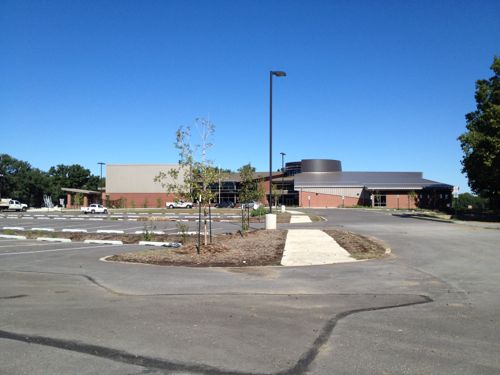
I had high hopes when it was announced the Saucer on Grand would be renovated rather than razed. Finally an opportunity to improve pedestrian access to what was originally built as a Phillips 66 gas station. I’d watched the construction going on but couldn’t get close enough to see any specifics.

I didn’t rush over on the morning Starbucks opened last week but I was encouraged when I saw a KMOX photo on Facebook with a highly visible blue crosswalk. Encouragement immediately turned to disappointment once I saw it in person.
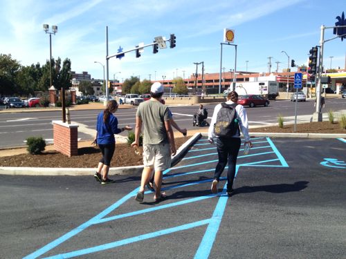
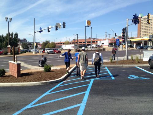
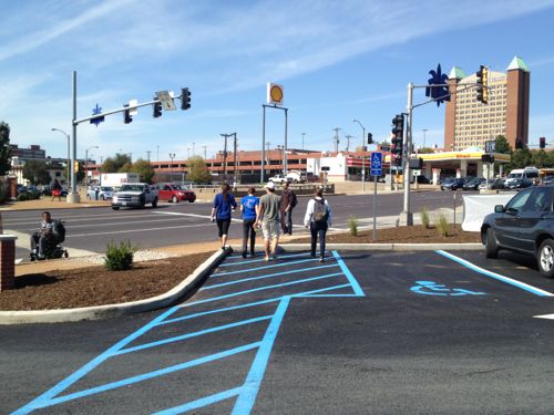
ABOVE: A group of students leaving the Starbucks at the Saucer on opening day. What’s the problem, they’ve got a designated walkway? Note the wheelchair user in the roadway because the public sidewalk still has unpassable areas from the construction.
ABOVE: The wheelchair user is further toward the auto exit and the pedestrians are closer to the public sidewalk.
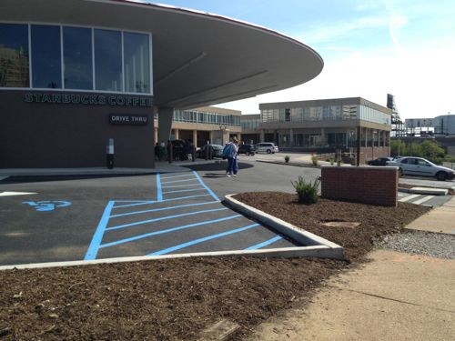
ABOVE: Now it’s clear that blue crosswalk serves a disabled parking only.
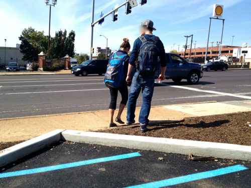
ABOVE: Up close we see these pedestrians using what appears to be a route to the sidewalk along Grand have to step over a newly poured curb and walk through a newly mulched area that’ll presumably have plants.
ABOVE: From the public sideway we can see how short the distance actually is, it would’ve been so simple to have the blue stripped walkway connect to the public sidewalk! Two people stand in the driveway because clear pedestrian space isn’t defined.
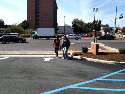
ABOVE: These two decided to walk in through the automobile out lane rather than walk through the mulch. Walking into the path of drivers as they’re just getting their coffee isn’t good, crossing the path perpendicularly in a marked crosswalk is safer.

The Saucer will be a huge draw for students who’ll very likely arrive as pedestrians. Most will come from the north. Others will come from the dorm across the street or from the medical campus to the south. No consideration was given to pedestrian from the west or south and a fix isn’t as simple as to the north.
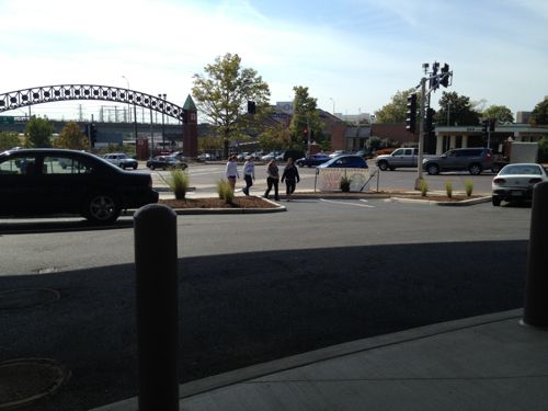
ABOVE: Students walk over curbs and through mulch, parking & a drive to reach the Saucer.

Yeah but it’s hard to make changes when working with an existing building…except if you recall everything was stripped away from the site except the Saucer’s roof structure!
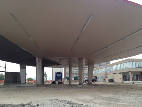
ABOVE: Fast forward to July 20th of this year and the structure was stripped down to just the saucer roof and the columns

This was poorly planned new site work. New curbs, new asphalt. The perfect chance to acknowledge the bulk of customers will be pedestrians from Saint Louis University.

Here are the results from the poll last week:

Q: Initial Reaction To The Updated Flying Saucer (Formerly Del Taco)?

  1. Impressive 62 [46.62%]
  2. I knew it could be great 48 [36.09%]
  3. I favored demolition but this renovation makes me glad it wasn’t razed 8 [6.02%]
  4. Unsure/no opinion 7 [5.26%]
  5. Other: 5 [3.76%]
  6.  They still should’ve razed it and built a more conventional building 3 [2.26%]

And the other answers:

  1. Good re-use of an old structure…but not mind blowing.
  2. It’s still a fast food joint.
  3. Could have been cool but disparate design elements are hideous.
  4. Meh
  5. Dishonest architecture doesn’t endure on its own merits.

I’m thrilled and disappointed at the same time.

— Steve Patterson
 

How Not To Do Retail Storefront Space

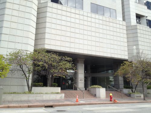
By the late 1980s many architects & planners began to realize a desire to include exterior retail spaces to enliven new buildings that would otherwise be lifeless at the sidewalk.  They were right, but their early execution left a lot to be desired. Case in point: AT&T’s data center from 1990.

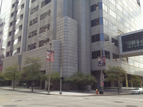
ABOVE: 801 Chestnut

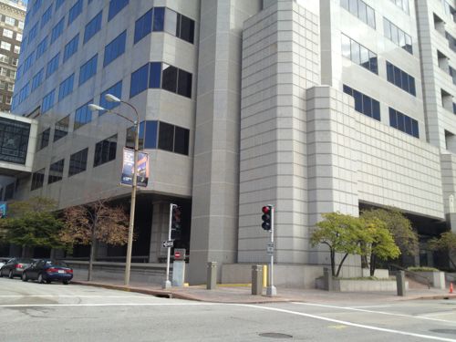
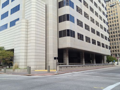
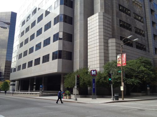
The building occupies the entire city block bounded by Chestnut on the south, 9th on the west, Pine on the north and 8th on the east (map). The building, built for Southwestern Bell, was designed to accommodate the planned westbound 8th & Pine MetroLink station that opened a few years later in 1993. Good coordination among different parties at least!

Let’s take a walk around so you can see all four sides.

ABOVE: The NW corner at 9th & Pine
ABOVE: The SW corner at 9th & Chestnut
ABOVE: The SE corner at 8th & Chestnut
ABOVE: The NE corner at 8th & Pine, the MetroLink sign is visible

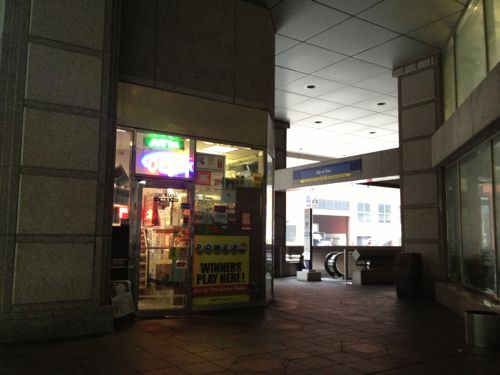
Did you see the three small retail spaces accessible by the general public? You didn’t? Only one is occupied, to my knowledge the other two have never had a tenant. The problem is they don’t face the sidewalks, they are hidden back in the dark recesses.

The occupied retail space is in the corner of the building pictured above, it just isn’t visible from motorists or pedestrians.

ABOVE: The space at the NE corner of the building, near the westbound 8th & Pine MetroLink station, is the only one that’s occupied. The entrance faces west, not the top of the escalators to the south. Even during the day it is dark in the area.
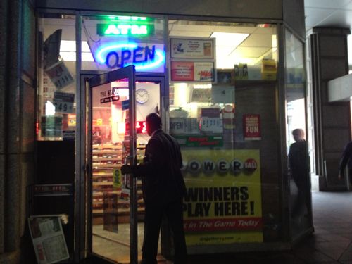
ABOVE: A customers enters the small convenience store while another exits MetroLink

The size of the space is appropriate, we do need more spaces like this adjacent to our light rail stations — but with the windows and door facing the transit users coming & going as well as visibility from adjacent sidewalks.  This is not too bad, if you exit the station here you will see the side window and investigate if you are thirsty.

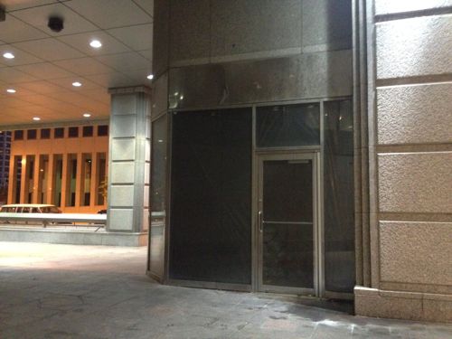
ABOVE: The vacant space at the NW corner, again not facing 9th or Pine
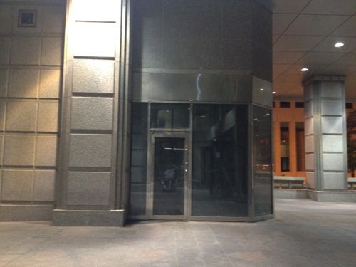
ABOVE: The third space in the SW corner near the main street entrance on Chestnut. But data center employes use the walkway over the 9th street to come and go.

I can just hear people downtown saying retail doesn’t work, using these as their examples. That these are still vacant more than two decades later would  have been easy to predict.

— Steve Patterson


Reaching The O’fallon Park Recreation Center

Previous posts on the O’Fallon Park Recreation Center covered the political standoff (Poll: Thoughts On The Not Yet Open O’Fallon Park Recreation Complex) and agreement (Readers Split On O’Fallon Park Controversy, Agreement Reached), today I want to talk about how to reach the Rec Center once it opens.

Many residents using the new facility, as well as YMCA/Herbert Hoover staff, will drive there. But others will walk or bike there and still others will come from further away riding the #74 (Florissant) MetroBus. I’ll cover all modes but lets start with transit and pedestrians.

ABOVE The southbound #74 MetroBus stops at W. Florissant Ave & Pope Ave, across the street from pedestrian access route.
ABOVE: Big beautiful homes on Holly Ave at W. Florissant Ave, two blocks north of Pope Ave

b

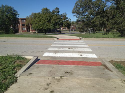
ABOVE: Several well-marked crosswalks allow pedestrians to cross W. Florissant Ave to enter O’Fallon Park. Pope Ave has a traffic signal to stop traffic.
ABOVE: A wide sidewalk works its way up the hill from Florissant & Pope.
ABOVE: Looking back downhill toward Florissant Ave. & Pope Ave.
ABOVE: This sidewalk crosses the main internal park road leading to the recreation center.
ABOVE: The sidewalk continues to the front door of the new facility.

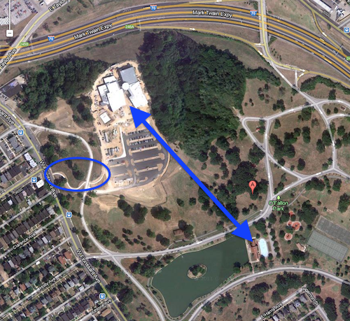
As the pictures above show, the pedestrian access from the nearby neighborhood, Florissant Ave. and MetroBus is excellent. A straighter path would be a shorter but not possible due to the grade change. Besides, if you’re going to work out saving a few steps probably isn’t a priority. Pedestrians just have to cross one internal park roadway, they don’t have to walk in it. Unless they are coming from or going to the O’Fallon Park Boathouse or if you live to the southeast of the park, across Harris & Adelaide Avenues, then access is tricky through the park or requires walking in the park roadway or going out to Florissant Ave and then back in.

ABOVE: A direct path from the Boathouse to the new Rec Center is needed. Pedestrian access circled in blue. Aerial from Google Maps, click to view.
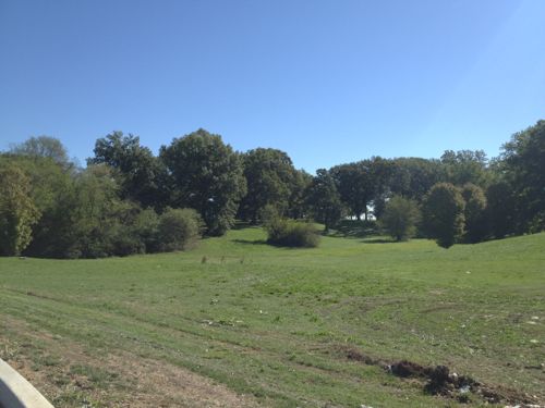
ABOVE: Connecting the new rec center and the historic boat house is complicated by the terrain. but this should’ve been considered when building a $20+ million facility.

On to bicycling and driving. Cyclists can use the roadway so from that perspective their fine but I have serious issues with the bike rack selection and installation.

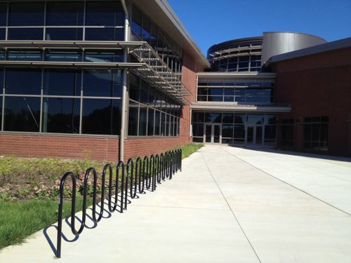
ABOVE: Empty bike racks in front of the unopened O’Fallon Park Recreation Complex

Architects love this bike rack design, even though it is a poor choice for securing a bike and most of the time they are installed incorrectly, as was the case here. When used as designed they can only secure the frame at one point, they should be loaded from both sides. The four racks shown here are designed to hold a total of 28 bikes. Another area with more of the same rack is to the left.

Better bikes racks would’ve been less expensive. Total failure on the part of the architects and/or client (city parks dept).

ABOVE: Sidewalks along the outside edges of the parking lot provide a safe path to walk to the building.
ABOVE: Bioswales collect rain water runoff from the asphalt parking lot.

With the exception of the choice of bike rack and lack of connection to the O’Fallon Park boat house and adjacent tennis courts I’d say access is very good. It’s far better than trying to reach the sister facility in Carondelet Park from nearby neighborhoods.

— Steve Patterson
 

New Nonprofit Formed Focusing On “(re)Connecting Cities” Through Pedestrian Networks

Metropolitan areas were once designed for pedestrians — compact with businesses accessed right off the public sidewalk. People lived and worked their entire lives in a very small area, there was no alternative. Streetcars and subways provided mobility allowing cities to expand in area, but people remained pedestrians when going to or leaving transit.

The private automobile changed things, requiring more and more space as more and more cars hit to the roads. As the car took hold land-use and buildings reflected this change. Tight grids of streets gave way to larger blocks without on-street parking in an effort to keep the cars moving.

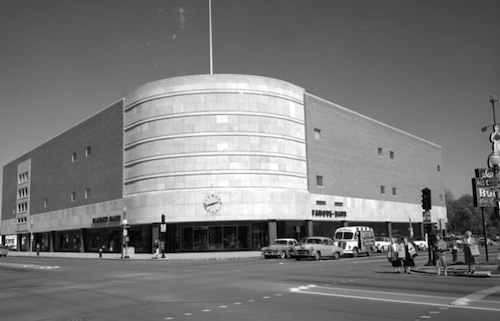
ABOVE: Southtown Famous-Barr at Kingshhway & Chippewa 1951-1992/3

Even then the street corner was still an important place. New department stores, such as the Southtown Famous-Barr, were built up to the sidewalk making the journey easy for pedestrians and motorists had plenty of parking as well. In the 1950s many still didn’t drive but since then new development began to forget about the pedestrian, making car ownership a necessity for the first time.

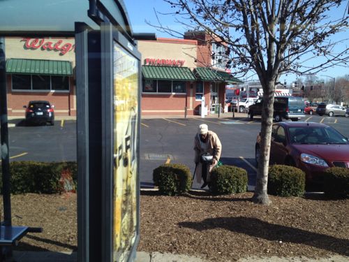
A Walgreens now sits on the same corner as the old Famous-Barr, its relationship with Kingshighway and Chippewa is radically different.

ABOVE: An elderly woman leaving the Walgreens had to walk through the parking lot and step up a curb while carrying her shopping bag.
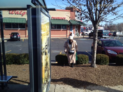
ABOVE: Yes she walks with a cane through the mulched area to reach the bus stop

Despite what you may think, not everyone in society drives. I don’t know this elderly woman’s history — she may have driven in her younger days but she’s not walking now for the fun of it. She walks though planted areas, parking lots, etc because we’ve designed our built environment in such a way this is the reality for many to buy the necessities.

This is a long way of introducing my new nonprofit:  (re)Connecting Cities. My idea is to advocate for all pedestrians, to work to make walking from the bus to the store and back not the undignified chore it is now.

(re)Connecting Cities will work to educate everyone on the benefits to society to connecting our buildings via sidewalks as well as we do for cars. Imagine if you had to drive through a muddy creek to get to the grocery store or over a pile of rocks — making a 4WD with high ground clearance a necessity? If you want milk & eggs you need a monster truck to do that.

We just expect roads, driveways and parking lots to be connected. Zoning makes sure there is an abundance of places to store vehicles yet in most cities/states nothing about being able to arrive on foot. Very unbalanced and unsustainable!

I don’t want to ban cars or have pedestrian-only streets, based on my research those rarely work in North America. I do want pedestrians to be given equal consideration when enacting zoning & building codes. I want architects, civil engineers and their clients to think about pedestrian arrival points, routes, and circulation, along with vehicular circulation. Communities often demand expensive traffic studies when a developer proposes a new project and nearby residents fear traffic congestion, yet a pedestrian access plan is never mentioned.

You’ll be hearing more about (re)Connecting Cities in the coming months and years.

— Steve Patterson
 

Building Over Light Rail

Yesterday I posted about moving the Union Station MetroLink platform into the former baggage tunnel (see The Union Station MetroLink Stop Should Be Moved Under The Train Shed), my reasoning was improved connection to Union Station. Today is the rest of my thought process.

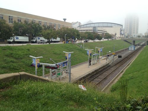
ABOVE: The MetroLink platform is located on the east side of 18th Street, totally exposed to the elements.
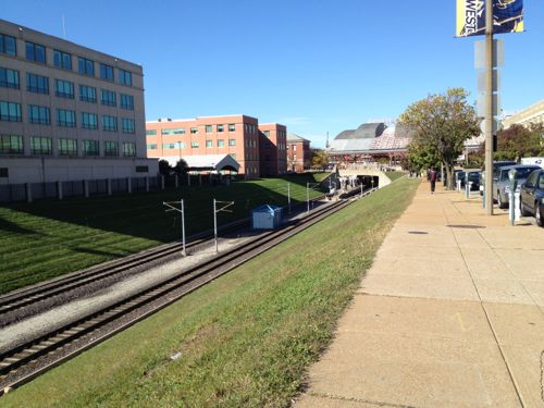
ABOVE: Looking west toward the Union Station MetroLink Station from 16th & Clark Ave.

It’s been a white but I’ve written before (link) that I want to see the tracks from 16th to 18th street built over with a new building(s). With the platform moved under the train shed the new building(s) in this two-block stretch wouldn’t have to deal with space for an entrance to the station, making it more straightforward.

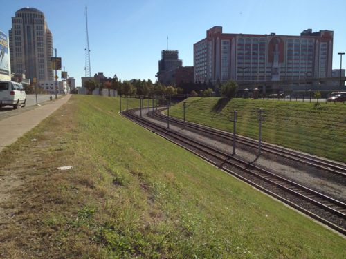
ABOVE: Looking east toward the Civic Center station from 16th & Clark Ave.

Another building could be built over the tracks for a block, before the track curves. This is basically from 16th to where the former 15th Street used to be. A walkway along the east edge could connect Clark Ave to the Gateway Transportation Center (Amtrak & Greyhound).

Back at 16th new buildings would be on each side to help frame the entrance into that area, now largely a jumble of surface parking. The area isn’t very big and has defined edges. Formerly this was an eight block area but the street grid has been dismantled to the point actual blocks are no longer recognizable.  It can become more connected so when someone arrives in St. Louis they can easily walk to Union Station or the Drury Inn on 20th facing the train shed.


— Steve Patterson
 

Advertisement


[custom-facebook-feed]

Archives

Categories

Advertisement


Subscribe