Home » Planning & Design » Recent Articles:

Locating Rec Centers

The City of St. Louis is building two new large ($20 million + each) recreation centers, one just completed in Carondelet Park (map), on the south side, and one just getting started in O’Fallon Park (map), on the north side.  As is typical of rec centers of this type, it turns out that access for people who won’t be driving seems to be both an afterthought and a real challenge. Bigger picture, this really shouldn’t be a surprise. There are three primary reasons. One, the majority of the users, especially the adult ones, WILL drive. Two, siting rec centers is a function of both budget and protecting departmental turf. And three, large rec centers, rightfully, generate the same NIMBY responses from many residential neighborhoods as many big-box retail developments – they operate long hours in large structures that generate a lot of traffic.

Parking at new Carondelet Rec Center, photo by Steve Patterson

When it comes to building new, modern, larger rec centers, rarely are there “enough” funds to do everything one would want to include, so the first decision is usually to locate the rec center in a park; after all, the land is/would be “free”, there is no specific line item for land acquisition. In reality, it’s never free. One, parkland is a finite resource, with multiple demands from multiple user groups to accommodate their programs. Land dedicated to a rec center and its parking lots can’t be used for, for example, soccer fields or Frisbee golf. And two, like any other greenfield development, utilities need to be extended from the park boundary into the site. Since these are large, multi-million dollar public investments, there’s also a tendency to want to make them monuments, and what better place to put one, where it will remain visible, for decades.

Both of these centers are/will be prominently located, visible from neighboring interstate highways (I-70 on the north, I-55 on the south). While this may be good for the civic and political egos, as well as for marketing their programs, it means that both utilities and pedestrians will need to travel a lot further from any park boundary to reach them, to say nothing of the physical barrier the highway creates. There’s also an assumption that there is a need to connect rec center activities with other park uses and facilities. In reality, there’s rarely little, if any, interaction among uses, although a few staff members may end up multi-tasking. For example, the locker rooms used for the gym and the pool don’t get used by softball players or picnickers, and home runs hit over the outfield fence don’t interact well with either the outdoor pool deck or a parking lot full of parked cars. Still there’s an inherent desire in any department to protect turf – if they give up a program, that can mean a reduction in both staffing and budget.

In the case of the new Carondelet Rec Center, the nearest bus stop is on South Grand, at Holly Hills Avenue, approximately 3 blocks from the rec center’s front door. Getting there, as a pedestrian, is possible – there is a sidewalk, but one that follows a circuitous route, first south on Grand to Holly Hills Drive, then east across an ancient (and non-ADA-compliant) bridge over the railroad tracks, then south along the east side of the new parking lot. It looks good, and somewhat “easy”, but if you’re riding the bus, because you’re young or disabled or just don’t want to drive, 3 blocks is still 3 blocks, especially when compared to all the free, at-the-door, parking offered to those who drive.

North entrance to park, no way into park for pedestrians
North entrance to park, no pedestrians access to rec center at left. Photo by Steve Patterson

With the clarity of 20/20 hindsight, I would’ve preferred to have seen both rec centers sited much closer to a major public street, and potentially located closer to the population centers of both sides of town. I also would have had no problem locating them outside a park, on land already under the control of the St. Louis Development Corporation. When I was researching both sites, I made the mistaken assumption that the north center was being located on the southwest corner of Taylor and Broadway, behind Metro’s North Broadway Metro Bus Center; there was dirt being moved on what appeared to be an ideal, and very-accessible, site. It turns out that, much like on the south side, that the north side rec center will be located near the center of O’Fallon Park:

httpv://www.youtube.com/watch?v=IUtG-9eo2JQ

And no, this isn’t unique to St. Louis. Whether it’s Richmond Heights or Des Peres, St. Peters or Fenton, Kirkwood or Chesterfield, most new rec centers end up being located in recreation complexes, ideally suited for the proverbial soccer moms (and dads) and their mini-vans, but not so much for even local kids on their bikes.  To move away from an auto-centric urban environment, we need to be doing more of what Clayton has done, either consciously or by coincidence, and less of what St. Louis and too many other suburban cities have done and continue to do.

The just opened rec center on the South side is operated by the YMCA as the Carondelet YMCA.

– Jim Zavist


Accessing the Lucas Park dog run

December 8, 2009 Accessibility, Downtown 10 Comments

When downtown residents began planning a downtown dog run a couple of years ago it was known then that at least one potential member/user from an adjacent building uses a wheelchair.

November 11, 2009

So I was surprised when I heard last month the newly constructed dog run in Lucas Park had accessibility issues.  The newly constructed sidewalk (above) ramps up to the gate.  Like any door that you pull toward you there is a need for at least 18″ on the handle side of the gate to permit entry.

You can see they had only a few inches to the side.  The paved area ends as well making wheelchair access a real challenge.

November 29, 2009

A few weeks later that previous entry sidewalk was ripped up and a proper sidewalk was in place. Because of grade changes this will allow access from the lower center section and the higher outside section.  Access inside is now possible.

A small part of the interior has also been paved to permit wheelchair access.  I’m continually baffled at both small and big projects that don’t take into considerations the needs of their users.  I would have caught this mistake on paper but a year ago I got pushed out of the planning committee because I wanted an open chain of communications (Yahoo or Google Group).  I had plenty of other items consuming my time so I didn’t fight to stay where I wasn’t wanted (but clearly needed).

– Steve Patterson


Much has changed in St. Louis over last 60 years, just not our zoning

December 6, 2009 Planning & Design, Zoning 5 Comments

In 1947 St. Louis’ long-time planner (1916-1950) Harland Bartholomew thought the city’s population would exceed one million by 1970.  Instead, between 1950-70, we lost 234,560 people to have 622,236.  We had 38% fewer people than he thought we would!

Bartholomew also thought we should have 35 airports in the region because, “developments in air transportation during the next few decades will parallel that of automobile transportation.” (source)  Born in 1889, Bartholomew hated our 19th Century “horse and buggy” street network.  His 1947 plan for the city has worked very hard to destroy the walkable city and to create the “modern” automobile city.  In his long career he advocated generous roads, parking and total separation of uses — housing, offices, etc should not be mixed in his view. He stood for the opposite of what cities are trying to accomplish today.

Bartholomew has been dead for 20 years now but St. Louis and so many cities follow his anti-urban thoughts simply because we have zoning he either authored or supported.  Local Aldermen will tell you that we change our zoning all the time.  True, on a case by case basis they’ll often change a zoning classification  — often to allow a better project than what the existing zoning allowed.  But rather than tossing out the 6 decade old vision for the city they cling to the power they have to support or oppose a request to change zoning.  So the ability for developers to do good urban projects comes down to their ability to grease the system to get the change they need or just accept the current zoning as a given and do a mediocre auto-centric project.

So what do we do? We begin the 4-5 year process to entirely replace our existing code.  Denver is nearing the end of this process now:

Denver, which currently has a zoning code dating to 1956, is the first large city in the country to undertake a complete rewrite of its zoning code and associated zoning map under a “form-based” and “context-based” approach. Because it will affect so many stakeholders, the AIA Denver Board of Directors and two AIA Denver committees have been following its development closely.

Of the intense four-year process of writing the code, putting it out for review, and revising, Brad Buchanan, FAIA, who sits on the Denver Zoning Code Task Force says: “We must be sure that the new code does not adversely affect the economic development potential in our city. In fact, this zoning code has the potential to increase economic viability while protecting the character both downtown and in our neighborhoods, which are the original economic engines for our city.”

From the city’s perspective, the new code is intended to support a growing economy, a sustainable environment, a diverse mix of housing, strong neighborhoods, and a high quality of life. (Source)

A new zoning code to guide future development is among the most important policy decision our Aldermen can make.  Of course, doing nothing is a decision.  From the Denver Post:

The 53-year-old regulations that guide land use and development in Denver are inconsistent, outdated and stifling growth, city planners say.

Now, after more than four years of work, Denver officials are on the verge of unveiling what they characterize as a cleaner, more user-friendly zoning code.

The post-World War II era, when the current code was adopted, was a time when planners were enthralled with the automobile. That era expected that much of the city’s existing historic architecture would get razed to make way for large-scale construction with extra space for parking.

But city planners now see value in old bungalows, Victorians and Four Squares that were written off in the 1950s. The current code has become an unwieldy mishmash of inconsistent, confusing rules and regulations that have the potential to actually harm neighborhoods, Park said. For instance, the existing code specifies that a new single-family home should be built on a lot of at least 6,000 square feet.

While that might work in “suburban-type” neighborhoods, it doesn’t conform to historic areas such as the Baker neighborhood, with smaller lots built on streets laid out in a grid pattern.

A more sensitive code

The new code will become more sensitive to the different characteristics that exist in the city and encourage development that blends in, Park said.

It will guide building forms and context for at least seven types of neighborhoods: suburban, urban edge, urban, general urban, urban center, downtown and special context. The regulations for those areas will differ depending on the existing characteristics of the neighborhoods.  (source)

Denver’s code can be viewed at newcodedenver.org.  The poll this week asks your thought — should we go this route and do a complete zoning rewrite or should we stick with what we’ve got?

– Steve Patterson


Architects & Engineers should be required to have their name on their work

Earlier in the week I walked past the Eden Lofts at Chouteau & 18th. The name of the firm that designed the building was proudly carved into stone near the entry.  It is a beautiful building, I’m sure they were proud.

This practice should be mandatory.  You never see the firm name on a Wal-Mart or a Quik-Trip and given their lack of architectural character it is no wonder.  Highway interchanges should include the name of the responsible firm.  City intersections should tell you who is responsible for how they function.

My belief is that is more people had to put their name on their work we’d see much better work.  Before the anti-government folks get all upset I want to make it clear I don’t want laws passed requiring this.  It would just be nice if it was still a common practice.

– Steve Patterson


Harland Bartholomew negatively impacted many cities

Twenty Ten years ago today famed urban planner Harland Bartholomew died.  From his NY Times Obituary, Harland Bartholomew, 100, Dean of City Planners:

Harland Bartholomew, the dean of comprehensive city planning in the United States, died Saturday at his home in Clayton, Mo., a suburb of St. Louis. He was 100 years old.

Mr. Bartholomew, a consulting engineer, was appointed to Federal planning committees by three Presidents, Herbert Hoover, Franklin D. Roosevelt and Dwight D. Eisenhower.

In 1941 President Roosevelt appointed Mr. Bartholomew to a committee to recommend a limited system of national highways. He also helped plan the Metro subway system in Washington, and he represented the Rockefeller interests in the restoration of historic Williamsburg, Va.

President Eisenhower appointed Mr. Bartholomew chairman of the National Capital Planning Commission a position he held for seven years, A City Planner in Newark Mr. Bartholomew became the nation’s first full-time city planner in 1914, when he went to work for the city of Newark. Two years later he went to St. Louis as a city engineer, and he later opened a consulting firm, Harland Bartholomew & Associates, which now has its headquarters in Memphis. He retired in 1965. His firm prepared comprehensive plans for more than 500 cities and counties, including Bal Horbour, Fla., St. Croix, V.I., and Grand Bahama Island in the Bahamas. Mr. Bartholomew also prepared plans for the reconstruction of the resort community of Bar Harbor, Me., after two-thirds of it was destroyed by a forest fire in 1947.

His firm also assisted in the preparation of many zoning ordinances. including a statewide ordinance for Hawaii.

He was an early advocate of slum clearance and city planning, and served on the national Slum Clearance Advisory Committee. His ideas helped shape the Housing Act of 1937 and the Housing Act of 1949.

There is no doubting Bartholomew’s influence on both cities and the profession of urban planning. His considerable influence is why he had such a negative impact on cities. We are still dealing with problems created by his solutions to early 20th century problems.

In 1919 he founded Harland Bartholomew & Associates here in St. Louis. For decades the firm operated from offices in the Louderman Building at 11th & Locust (map). From 1916-1950 he was St. Louis’ planner.

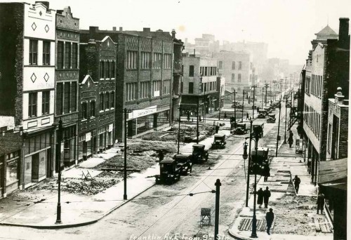
Franklin Ave looking East from 9th, 1928. Collection of the Landmarks Association of St Louis

Early writings showed he was concerned about suburban expansion — in the 1920s. He advocated widening streets to accommodate the automobile. In the above image the right-of-way of Franklin Ave from 3rd to 9th is getting widened from 50 feet to 80 feet – a 60% increase! Widened streets and numerous parking lots/garages made the decision to buy a car and move to a house beyond the streetcar line was a no brainier for many.

Soon the widened streets weren’t enough so highways were the next step. Each time steps were taken to make motoring life easier the further people moved from the core. Eventually families needed to have two cars. As a country we would have embraced the automobile anyway but he made it easier and faster. Highways cutting through cities also did much damage.

Bartholomew was a major pusher of Euclidean zoning — the rigid segregation of land uses. Overcoming this segregated view of cities today is a challenge. I’ve spent time in the basement of the Washington University archives library reading through comprehensive plans HBA prepared for hundreds of U.S. cities. Each one a repeat of the prior: widen streets, build a highway loop around downtown, build parking, require high parking standards for new construction, make the zoning even stricter.

Harland Bartholomew left his position with the City of St. Louis in 1950 and after 42 years, in 1961, he retired from the firm that bore his name. I can’t help but think our cities would be better off in the 21st century if this man born in the 19th century had become an accountant. I take some pleasure knowing the building where his office was located currently includes a mix of retail, office and residential uses.

– Steve Patterson


Advertisement


[custom-facebook-feed]

Archives

Categories

Advertisement


Subscribe