Home » Planning & Design » Recent Articles:

Remembering Sculptor Carl Milles (1875-1955); 75th Anniversary of Aloe Plaza Next May

Aloe Plaza, across Market from Union Station, was many  years in the making. President of the Board of Aldermen (1916-1923) Louis P. Aloe had championed a 1923 bond issue that included razing buildings across from Union Station to create a more attractive way to welcome visitors arriving by train.  Aloe died in 1929 but his widow continued his vision, from the city’s former website on Aloe Plaza:

Edith Aloe, Louis P. Aloe’s widow, became acquainted with the work of the Swedish sculptor, Carl Milles, at an exhibition of modern art held by the St. Louis League of Women Voters in 1930. The idea of commissioning Milles to build a fountain in Aloe Plaza grew out of her enthusiasm for his work.

But the country was in the middle of the Depression so her idea was put on hold until January 1936 when Mrs. Aloe gave a dinner in her home for the sculptor,Carl Milles, and members of the St. Louis Art Commission. She officially presented her check for $12,500.

The City signed a contract with Milles in 1936. Milles designed and cast the bronze statues for the fountain in his studio at the Cranbrook Academy of Art, Cranbrook, Michigan. The fountain was completed in November 1939, but remained veiled until its dedication on May 11, 1940 before a crowd of 3,000 persons.

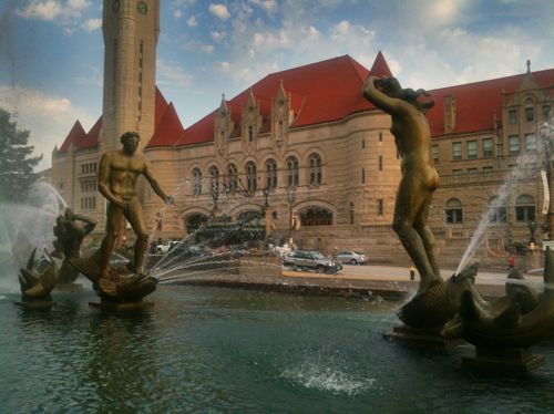
The fountain, originally named “The Wedding of the Rivers,” depicts the union of the Missouri and the Mississippi Rivers, represented by the two central figures. Accompanying the two main figures and forming a wedding procession are 17 water spirits, symbolic of the smaller streams that empty into the two major rivers.

An uproar arose over the nudity of the male figure, reprenting the Mississippi River and the female figure, the Missouri River. In deference to the criticism, the name of the fountain was changed to ,”The Meeting of the Waters.” (PDF of website on Scribd)

Milles was in his early 60s when we was commissioned by St. Louis.

The former website listed the total cost of Aloe Plaza at $225,000, broken down as follows:

  • Fountains: $150,000
  • Statues: $60,000
  • Lighting: $12,000
  • Landscaping: $3,000
  • Tulips: $200

The cost of the tulips wasn’t included in the total. Not listed was the cost to acquire the land and raze the buildings.

Carl Milles, date unknown, Source: findagrave.com, click to view
Carl Milles, date unknown, Source: findagrave.com, click to view his memorial
Carl Milles' 'Meeting of the Waters' is the focal point of Aloe Plaza
Carl Milles’ ‘Meeting of the Waters’ is the focal point of Aloe Plaza

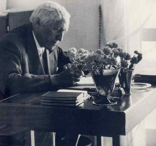
Milles died on this day in 1955 — 59 years ago.

May 11, 2015 will mark 75 years since Aloe Plaza was first dedicated and ‘Meeting of the Waters’ unveiled. Our IKEA store won’t be open yet, but perhaps the Swedish retailer can be involved in a celebration.

— Steve Patterson


Land Hogs: Urban Highways

Urban interstate highways, especially their interchanges, a major land hogs. The other day on MetroLink heading to Lambert Airport the extent became very visible.

The EB I-70 ramp onto NB I-170
Traffic from I-170 merging with WB I-70
Using Google Maps I calculate this interchange consumes 154 acres, about 1/4 of a square mile

One quarter of a square mile isn’t much, is it?  At current density levels this would be enough to house:

  • 475 people (St. Louis County)
  • 1,200 (St. Louis City)
  • 2,845 (Chicago)
  • 17,000 (Manhattan, NYC)

Urban highways reduce overall density, place barriers that further separate us. I’m not saying we change this particular interchange, just recognize what highways do to urbanized areas (vs rural).

— Steve Patterson


Temporary Barriers Still Surround The Thomas F. Eagleton U.S. Courthouse In Downtown St. Louis

Fourteen years ago today the new Thomas F. Eagleton U.S. Courthouse opened in downtown St. Louis, a year later was the terrorist attack on U.S. soil.  The 9/11 attack meant immediate security changes around the year-old courthouse, these temporary fixes remain with us today. The big change involved Jersey barriers — lots of them.

Looking north on 11th toward  Walnut
Looking north on 11th toward Walnut you see the west side drop-off area is blocked
Looking West on Clark toward 11th
Looking West on Clark toward 11th, at right you can see concrete benches designed to act as barriers.

This courthouse was designed well after the 1993 World Trade Center bombing and 1995 Oklahoma City bombing, yet despite the built-in efforts to protect the building, the Jersey barriers have been in place for all but the first year.  I’d like to see a different solution, something that looks less temporary.

— Steve Patterson


East-West Gateway’s ‘Great Streets’ Examined W. Florissant In Jennings, Ferguson, & Dellwood

Looking South on W. Florissant in Dellwood, MO

A reader comment on West Florissant Ave Part 2: QuikTrip to Chambers Rd alerted me to the fact the Great Streets Initiative, through the East-West Gateway Council of Governments, had recently looked at West Florissant:

Vision Statement:
The Vision for West Florissant Avenue comes from community and stakeholder input received through multi-faceted outreach efforts. These have included public workshops and virtual walking tours, interviews with community leaders, input from the Community Committee and Technical Advisory Committee, an Agency workshop, and an online survey and mapping tool. The Vision Statement has distilled this community and stakeholder input, with the most significant community values expressed as how the corridor should look, feel, and contribute to the community’s future. 

Project Area:
The West Florissant Avenue Great Streets Project area is located in North St. Louis County, within the cities of Ferguson and Dellwood (Map 1.1). The Project area extends for approximately 2.6 miles, beginning at I-270 in the north and continuing to the East-West rail line at Emerson Electric headquarters and Buzz Westfall Plaza in the south (Maps 1.2 and 1.3; note change in map orientation). Th e Project area includes parcels that front the corridor, plus additional parcels along the key intersecting streets of Pershall Road and Chambers Road. Th e street corridor itself is owned and maintained by St. Louis County. Th e Project area parcels are about evenly divided between the cities of Ferguson and Dellwood; a few parcels also fall within Jennings city limits at the southeast end of the corridor. Several key landmarks and retail centers are located within or near the Project area. Dellwood City Hall is near the intersection of West Florissant Avenue and Chambers Road. The Project area also includes Dellwood Park and Dellwood Recreation Center. St. Louis Community College Florissant Valley Campus is just outside the northwest end. In addition to these landmarks, there are 160 acres of open space or park within one mile of the Project area, including open space associated with Maline Creek. A major shopping center is at the northern end of the corridor, with access to I-270. Just outside the southern end of the Project area, Buzz Westfall Plaza is another major retail center. The West Florissant Avenue corridor has been designed primarily to serve motorized vehicles, which is reinforced by the direct access to and from I-270 the road provides. The corridor is served by Metro Transit bus route #74, one of the most heavily-used lines in the system, and a future transit center is planned for Pershall Road in the northeast part of the Project area; its estimated completion date is in 2015. While sidewalks are present, many other pedestrian amenities are not, and the corridor is not pedestrian-friendly. The corridor currently does not have designated bicycle facilities, and is little used by bicyclists. As communities take an increasingly holistic view of streets and incorporate more of these Great Streets principles, our streets will serve multiple functions and become better places.

The supporting documents are on their West Florissant page, I’ve uploaded each to Scribd for quick reference:

The collection of the above can be viewed here.

I hope to dig into these documents soon, but I’m happy to know so much effort has already gone into planning for a better W. Florissant!

— Steve Patterson


Perfect Location For Centene’s New Ferguson Claims Center

Earlier this week one local company stepped up to invest in Ferguson:

Centene Corp. has selected Ferguson, the site of unrest for more than three weeks following the police shooting of Michael Brown, as the location for a new claims processing facility, with plans to bring up to 200 jobs to the city. The unrest following Brown’s death prompted Centene to select the city for the expansion. (stltoday)

This is potentially great news! I say potentially because most major call centers fit perfectly in an exurban office park; generic building sounded by massive surface parking lots, all fenced in. Ferguson needs these jobs, but it needs them in an engaged environment. Where? What would it look like? The where is quite simple: Emerson owns the perfect site on the SW corner of W. Florissant & Ferguson Ave., 9001 W. Florissant Ave.

This corner is 7+ acres
Looking north from an adjacent Ameren substation
Looking north from an adjacent Ameren substation, the Ferguson Market is in the background
Looking north from in front of the Ameren substation
Looking south from Ferguson Ave
Map of the site consisting of two parcels, both owned by Emerson
Map of the site consisting of two parcels, both owned by Emerson, right of the purple line is Jennings

I’m not sure why Emerson bought this property, likely to raze the structure that was on the site as of 1971. Having a neighbor like Centene could be beneficial to Emerson, more workers means more lunch places. Hopefully Emerson would be willing to sell to Centene, or partner on a project to develop the site. And build what?

What they shouldn't build is a building surrounded by parking
What they shouldn’t build is a building in the center surrounded by parking
Instead, the building should be pushed out to the corner so pedestrians can easily reach the entrances.
Instead, the building should be pushed out to the corner so pedestrians can easily reach the entrance(s).

Ideally the building would be at least two floors, with the first floor for retail. I’d like to see a St. Louis Bread Co (aka Panera*) or Chronicle Coffee on the corner. This would provide additional jobs and more places for these 200 employees and those who work in the area to get breakfast, lunch & dinner. Nearby locally-owned places like Ferguson Burger Bar & More would also benefit. Parking can be located behind the building. If Centene doesn’t need this much space the site could be planned for more than one building facing W. Florissant.  * Disclosure: I have a handful of Panera stock

If Ameren built a new substation at the back corner, an auto entrance could be created at the traffic signal at Solway Ave.

A project at this corner could be a great way to implement East West Gateway’s Great Street master plan for W. Florissant!

— Steve Patterson


Advertisement


[custom-facebook-feed]

Archives

Categories

Advertisement


Subscribe