Home » Planning & Design » Recent Articles:

Raised Crosswalks Should Be Used More Often

Everyone is likely familiar with what a crosswalk looks like, ramps on each side sloping down from the sidewalk level to the street level. Ever stop to wonder why the pedestrian must come down to street level then back up to sidewalk level on the other side of the street? With the raised crosswalk it is reversed:

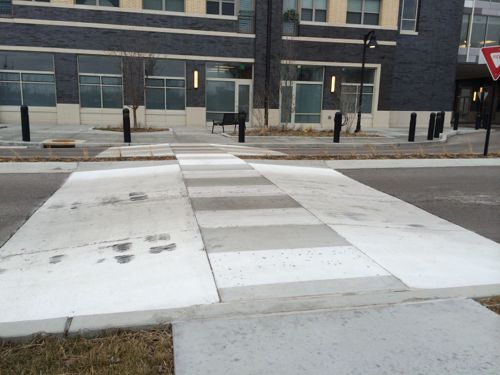
Raised crosswalks are marked crosswalks that are raised to act simultaneously as a speed hump. Approach markings signal to drivers that the crosswalk is raised. Crosswalk markings or contrasting crosswalk materials (pictured) show this element is also a crosswalk. As both a marked crosswalk and a traffic calming element, raised crosswalks provide a superior safety advantage to pedestrians. Raised crosswalks are most appropriate on streets with only moderate traffic (<10,000 trips/day), such as a minor collector, or a residential street with a significant conflict between pedestrians and vehicles. This type of facility is particularly effective where heavily used trails cross a road. (Streets Wiki)

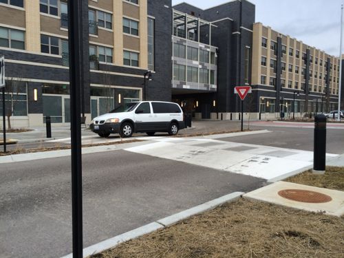
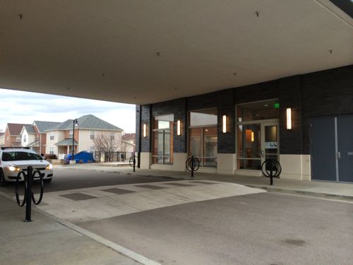
This is not a crosswalk you’d use across a busy aerial, like Kingshighway. It’s great in lower traffic areas where lower speeds are desired. Several crosswalks around the new Jazz at Walter Circle senior housing in East St. Louis are raised crosswalks:

Raised crosswalk on N. 15th  in East St. Louis, the new Jazz at Walter Circle senior housing building in the background
Raised crosswalk on N. 15th in East St. Louis, the new Jazz at Walter Circle senior housing building in the background
Another raised crosswalk on Walter St.
Another raised crosswalk on Walter St., bike parking is protected from weather and highly visible
A raised crosswalk brings the crosswalk up to the level of the sidewalk

The raised crosswalk makes the pedestrian network easier to plan & construct. My guess is the construction costs are probably a wash, but with greater benefits of increased pedestrian safety.

Related to the raised crosswalk is the raised intersection, I don’t know of a local example to show you.

— Steve Patterson


Readers: Mixed-Use Building Better Than Laclede’s Landing Park

I agree with the majority of the voters in last week’s poll, a mixed-use building would be better than a park in Laclede’s Landing!

The planned park space is to the right of the trucks parked in the alley, click for larger image.
The planned park space is to the right of the trucks parked in the alley, click to view larger image.

Q: Great Rivers Greenway Bought Laclede’s Landing Property, Plans Park. Thoughts?

  1. A mixed-use building would be better 53 [51.96%]
  2. A park is a good idea 21 [20.59%]
  3. A residential building would be better 15 [14.71%]
  4. A Taco Bell with drive-thru would be better 4 [3.92%]
  5. Other: 4 [3.92%]
    1. greenway along the river
    2. “Other Compatable Development” appears to leave much open to consideration.
    3. Park? Restrooms? Sounds like a great place for the homeless!
    4. It’s a nasty dirty area
  6. Unsure/No Answer 3 [2.94%]
  7. A parking garage would be better 2 [1.96%]

Laclede’s Landing is barely a place anymore, with so many holes in the formerly urban fabric. Between grassy blocks are harsh surface parking lots, it’s clear there needs to be a plan to infill some of these holes with new construction. It make take 20 years to happen, but the planning needs to happen now.

The site of the former Switzer Building, recently purchased by Great Rivers Greenway, is shown with the red X. Click to view in Google Maps.

With such a tiny amount of land between the King & Eads bridges I think every bit should get filled in. Knowing that isn’t likely, the land closer to the south should be filled in while land to the north isn’t as critical to completing streetscapes and urban vistas.

But if Great Rivers Greenway goes ahead with this park next to the Eads Bridge, what should we call it? Eads Transit Park?

Metro dedicated the Eads Transit Park on May 16, 1996. I'm not sure what year they padlocked it.
Metro dedicated the Eads Transit Park on May 16, 1996. I’m not sure what year they padlocked it.

A tiny park next to a massive park that is growing in size by the size of the Arch parking garage and the width of Washington Ave is a huge mistake! This land is an opportunity to add much-needed building mass, people, activity, etc right next to a light rail station. Great Rivers Greenway can’t get into the development business but I’d think they could buy and hold for a developer. If they really have the urge to green up Laclede’s Landing they could unlock Metro’s Eads Transit Park and/or do something with the mess under the King Bridge.

This land needs help that Great Rivers Greenway could provide, a green park extending toward the city from the riverfront leading cyclists up and into Laclede's Landing.
This land needs help that Great Rivers Greenway could provide, a green park extending toward the city from the riverfront leading cyclists up and into Laclede’s Landing.


Hopefully Great Rivers Greenway will reconsider, so the land adjacent to the Eads Bridge might someday see new constriction. Maybe a demonstration is needed to convince them?

— Steve Patterson


Private Gate Blocks Public Sidewalk in Midtown, Ties to the Castle Ballroom

Often I encounter annoying things as I make my way around the city, dismissing many as flukes. I took photos of a gate blocking the public sidewalk on November 28, 2012 and again on March 7, 2014.

Looking north, November 28, 2012
Looking north, November 28, 2012 @11:10am
Looking south, November 28, 1012
Looking north, March 7,  2014
Looking north, March 7, 2014 @ 1:50pm
Looking south, March 7,  2014
Looking south, March 7, 2014

This is the side gate for 2840 Locust St., owned by Barry Adelstein & Scott Gundolf. Years ago the renter of the property was Michael McMillan, former alderman, license collector, and cureently head of the Urban League of St. Louis. To my knowledge he still lives here. This property is directly north of the neglected Castle Ballroom.

The owner of the Castle Ballroom is SAG PROPERTIES LLC, with tax bills sent to 2840 Locust St.  Documents show Scott Gundolf is the President of SAG Properties LLC.   He’s also a licensed real estate broker with One West Associates, Barry Adelstein is also a licensed broker.

Just what is the relationship between Michael McMillan, Barry Adelstein, and Scott Gundolf? McMillan’s close associate, Marlene Davis, became the 19th ward alderman when he was elected to the office of license collector. Adelstein was a partner with Marlene Davis in a failed midtown bar, Gene Lynn’s, which closed in 2008.  Davis was forced to file for bankruptcy in 2010.

Did these associations help get officials to look the other way regarding maintenance of the Castle Ballroom building? And to a lessor degree, feel like it’s ok to block the public sidewalk with a private gate? But wait, there’s more!

The real estate deal in question involves the old Castle Ballroom at 2839 Olive, which Rainford says Reed bought and sold for a large profit, before helping the developer who bought it get a taxbreak. Reed’s campaign says sale was profitable, because it happened during the 2004 market peak; and the tax break was sought by the alderman in that ward, passed unanimously by the board, then signed by Mayor Slay. (KMOX)

A tax break? There’s much more to this, I suspect! Plus I don’t want the gate left open blocking the public sidewalk.

— Steve Patterson


Poll: The Number of Stop Signs in St. Louis is…

Please vote in the poll, located in the right sidebar

St. Louis is known for the St. Louis stop:

an action where you come up to a stop sign look both ways but never actually make a complete stop

People complain about them but many also request they be added at their corner. In the poll this week I’d like readers to finish the statement “The number of stop signs in St. Louis is…”

The answers range from not enough to excessive, appearing in random order in the poll in the right sidebar. The poll results and my thoughts on Wednesday March 19th.

— Steve Patterson


Chippewa Road Diet, Bike Lanes, Pedestrian Lane

Late last year Chippewa got a road diet using paint, not concrete. Four traffic lanes were reduced to two with a center turn lane, and a bike lane was added in each direction.  Under the railroad bridge between Gravois & Meramec was the part that confused me, with a wide lane to the right of the new bike lane. The other day I was finally in a place where I could get some photos.

Looking east you see the westbound  bike lane to the right of the orange cones.
Looking east you see the westbound bike lane to the right of the orange cones.
Looking west toward Morgan Ford
Looking west toward Meramec

Because of the railroad tracks pedestrians haven’t been able to  walk in an east-west direction along Chippewa. Up top the tracks are a barrier and the underpass was designed decades ago only for vehicles.  Online I found Chippewa Bike Lanes: A Review:

The pedestrian lane under the viaduct seems like a creative and appropriate solution to the problem of pedestrian connectivity along aging infrastructure. It is important that the pedestrian lane be separated from automobile traffic, and the traffic cones are obviously a temporary fix. We look forward to seeing the permanent configuration, and will update this post as the project evolves. 

Hopefully the traffic cones are just temporary, but replaced with what? The excellent images on the post Chippewa Bike Lanes: A Review show how lanes shift, with the risk of motorists ending up driving in the bike/pedestrian lanes.

— Steve Patterson.


Advertisement


[custom-facebook-feed]

Archives

Categories

Advertisement


Subscribe