Home » Planning & Design » Recent Articles:

Edwardsville School Board Considering $1.3 Million for Elementary School Parking Lot, Razing Historic Church

Parking is a perceived issue all over the region, even in small towns like Edwardsville IL. The public school district is considering purchasing a historic church, and an adjacent house owned by the church, to create more parking for Columbus elementary school:

The general terms of the proposed sale, which are all subject to approval by both the First Presbyterian Church congregation and the District 7 Board of Education, are that the district will pay First Presbyterian Church $1.3 million from impact fees over a 10-year period. Impact fees are money collected from developers who build homes in Edwardsville and Glen Carbon. The fees can only be used for new construction or the purchase of property.

The other terms of the negotiation are that First Presbyterian Church would have four years to vacate the existing church facility, and the church would be responsible for preparing the ground to leave a clean, level site. (District 7 looks to turn church into parking lot)

The $1.3 million is just for the land, it’ll cost more to actually develop the parking lot.
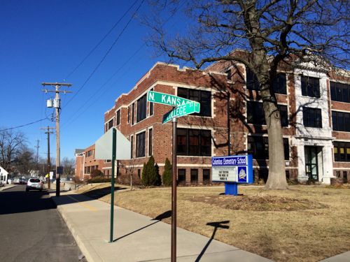
Columbus Elementary just east of Main Street in downtown Edwardsville, click for map
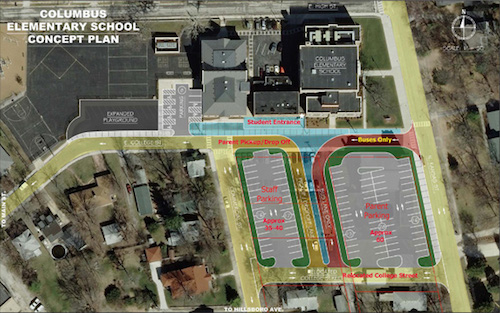
Graphic showing staff parking (left) and parent parking (right)    Source: Edwardsville Intelligencer, click for story
Graphic showing staff parking (left) and parent parking (right)
Source: Edwardsville Intelligencer, click for story

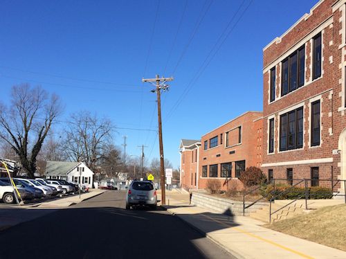
A friend drove me over to Edwardsville last week so I could check it out in person. What we found is the school has a small parking lot for staff, a large asphalt playground, and has use of a couple of small parking lot owned by the church. No doubt when the church has a weekday event, like a funeral, parking gets tight. Otherwise both appear to have coexisted for decades.
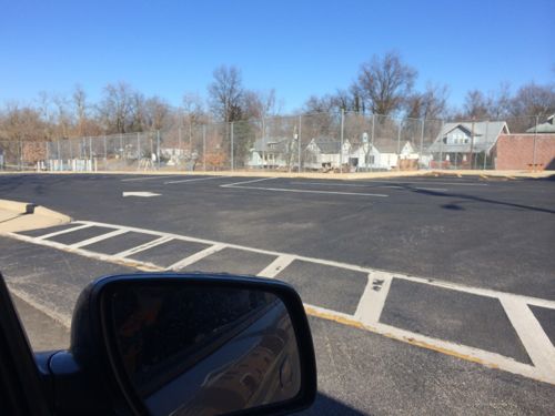
Looking west on College, the church-owned lot on the left wasn't full at 9:15am last Thursday morning
Looking west on College, the church-owned lot on the left wasn’t full at 9:15am last Thursday morning
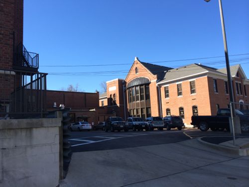
Back parking lot of school appeared full
Parking on school grounds on the west side of the building was completely vacant

I don’t live in Edwardsville, nor am I a parent, so I turned to the Edwardsville School District 7 Parents group on Facebook to see the discussion. There were several postings, here’s some quotes I selected from hundreds:

Feb 26: “Anyone know why Columbus needs a $1.3 million parking lot? More than say, teams, all tenth graders on campus, enough honors classes, a daily middle school band/orchestra program?” — LW

“because there is ZERO parking at the school and the church next door was kind enough to let the school “share” their parking lot. The church is moving and the new owners may not be as accommodating!” — LC 

“We always parked in that lot…..sad to see the church go…I went to preschool in that church” — JG

“The church isn’t moving unless the building is purchased. We’ve always worked with the district for parking and that’s not a big deal. My ‘big deal’ is a $1.3 million parking lot. I have a 7th grader who can’t have team teaching or have band every day because there’s no money, a junior who spent 40 minute a day last year being transported off campus because there weren’t enough classrooms, and it makes no sense financially. If there’s money to buy property and or build something with, maybe an addition to the high school would be a goal to look toward.” — LW

Feb 26: “Is it true that the Presbyterian Church property was assessed at $750,000? If so, wouldn’t that lend one to believe that the tax payers are indeed paying for demolition?” — TM

It appears the parents in the district are split; some say the parking situation is poor, while others say parking has always been bad but the district has higher priorities. I do know the school & church have managed to share parking in the area for years but it the church is razed much of the parking will sit empty each day.

This is all possible because some members of the dwindling congregation at the First Presbyterian Church of Edwardsville want to build a new church nearly 4 miles away. This isn’t new, they bought 28+ acres of farmland in January 2000, paying $390,000. In November 2006 I posted how they voted to build on the farmland.
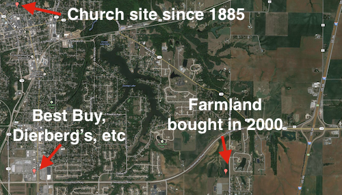
The future church location is on the far east edge of town, away from downtown and the new sprawl shopping.
The future church location is on the far east edge of town, away from downtown Edwardsville and their new shopping area. Click image to view map.
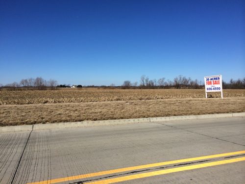
The church hopes to sell 20 acres to partially  fund the new building on the remaining land
The church hopes to sell 20 acres to partially fund the new building on the remaining land
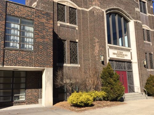
First Presbyterian was founded in 1819, moved to this site in 1885. The current building was dedicated on the same site in 1924.

Attendance at the church has reportedly dropped in the 7 years since voting to proceed with the plan to build a new church.  I can see the church agreeing to sell  — but in four years still not having a new building ready. Then what? Also, does the school district not have more pressing building needs?

— Steve Patterson
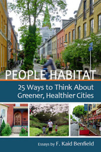
 

People Habitat: 25 Ways to Think About Greener. Healthier Cities by F. Kaid Benfield

Cover of the softbound book, $25

Decades ago books on cities talked about razing buildings, clearing away the old to make way for the new, segregating uses & people, etc.  These days the subjects are sustainability, health of the inhabitants & the city, regionalism, etc. This shift requires new ways of thinking about old problems. Enter People Habitat: 25 Ways to Think About Greener, Healthier Cities by F. Kaid Benfield:

With over 80 percent of Americans now living in cities and suburbs, getting our communities right has never been more important, more complicated, or more fascinating. Longtime sustainability leader Kaid Benfield shares 25 enlightening and entertaining essays about the wondrous ecology of human settlement, and how to make it better for both people and the planet.

People Habitat explores topics as diverse as “green” housing developments that are no such thing, the tricky matter of gentrifying inner cities, why people don’t walk much anymore, and the relationship between cities and religion. Written with intellect, insight, and from-the-heart candor, each real-world story in People Habitat will make you see our communities in a new light. (Island Press)

You can view the table of contents and read excerpts at peoplehabitat.comPeople Habitat: 25 Ways to Think About Greener, Healthier Cities by F. Kaid Benfield is available locally through Left Bank Books.

— Steve Patterson


Sidewalks In Chicago

Last weekend my fiancé and I went to Chicago for a 3-day weekend. I’ve been numerous times since my stroke 6+ years ago, including last August, but each of those visits was by car with me as passenger or driver. This trip we took Amtrak so I could use my wheelchair since our primary reason for going was to see the Chicago Auto Show. I know here in St. Louis my chair can easily get stuck in just a tiny amount of snow so I was nervous about going to Chicago where they had lots more snow. As soon as we exited Chicago’s Union Station I realized how much Chicago values all modes of travel: auto, bike, bus, foot, chair.

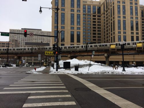
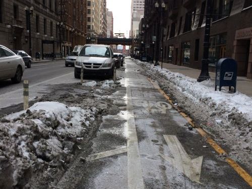
Sidewalks, roads, ADA ramps connecting sidewalks and crosswalks were all cleared.
Sidewalks, roads, ADA ramps connecting sidewalks and crosswalks were all cleared. This photo taken at Harrison & Wabash, click for map.
A protected bike lane on S. Dearborn was cleared of snow.
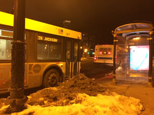
All the bus stops/shelters had been cleared as well allowing us the use various CTA bus lines

You might be thinking “Sure, in the Loop. What about in the neighborhoods?” Friends picked us up for dinner Saturday night, driving us for Lebanese at Semiramis, located miles away from downtown at 4639 N Kedzie Ave.  The sidewalks, ramps & crosswalks were also cleared there.

— Steve Patterson


Two Locally Preferred Bus Rapid Transit (BRT) Routes Selected

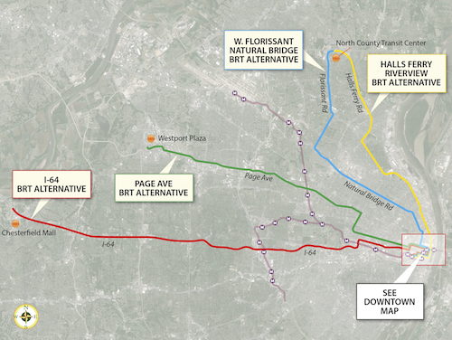
In September readers picked the I-64 BRT route between downtown and Chesterfield as their favorite of four bus rapid transit (BRT) routes being studied by the Transportation Corridor Improvement Group (TCIG), which “consists of staff from Metro, EWGCOG, the City of St. Louis, St. Louis County, and MoDOT”.

“None” was 2nd in the poll, but the next actual route favored was the West Florissant – Natural Bridge BRT option. On Tuesday the TCIG recommended two locally preferred alternative routes to Metro’s Operations Committee

After careful consideration and analysis of the transportation corridors, the TCIG recommended as the locally-preferred alternative two BRT projects: I-64 between Chesterfield and Downtown St. Louis, and a north-south route connecting North St. Louis County to Downtown St. Louis primarily via West Florissant Avenue and Natural Bridge Avenue.

See their report/presentation here.

The four alternative BRT routes that were being studied.
The four alternative BRT routes that were being studied, click image to view larger version.

Let’s take a closer look at the two selected routes, from Tuesday’s report:

I-64 BRT (route)

The 1-64 BRT corridor spans 23 miles between the City of Chesterfield and Downtown St. Louis. It would serve a limited number of park-and-ride stations along I-64 between Chesterfield Mall and the Central West End. From the Central West End it would travel along Forest Park Avenue into Downtown St. Louis, making a loop through Downtown before ending at the Civic Center Station. As currently proposed, its service frequencies would match MetroLink, and transit prioritization strategies would be implemented along the corridor to speed transit travel.

The I-64 BRT would serve a Central Corridor that hosts 55,000 people and 115,500 jobs within one half-mile, outside of Downtown St. Louis. The addition of this high-performance service to the Metro System would provide the region’s first rail-like transit option in West St. Louis County, offering the first opportunity for all-day, single-seat service between Chesterfield and Downtown St. Louis, and reducing transfers from other areas by half. Along with reducing transfers, it would improve transit travel time within the corridor by 30%, making it a much more attractive alternative to the personal automobile. Ridership projections from EWGCOG’s regional travel demand model show a potential ridership market of 5,100 weekday riders, 2,100 (41%) of whom would be new “choice” riders. That market is projected to grow to 6,800 weekday riders by 2040.

I-64 BRT CONSUMER BENEFIT

  • End-to-end transit travel time reduced from 76 minutes to 53 minutes
  • – Compared to auto travel time of 25 minutes
  • – Offers motorists option of comfortable, affordable, productive commute
  • Corridor ridership projected to increase 357% from 1,115 to 5,100 weekday riders opening year; 6,800 in 2040
  • – 2,100 (41%) new “choice” riders opening year
  • Enhanced service
  • – BRT option provides single-seat service not currently available
  • – Reduce transfers by 50%
  • – End-to-end service available all day, rather than only peak
  • – Create additional hubs to make local bus service more efficient

This route makes a lot of sense to me. It gets a higher level of transit service on this corridor without the enormous infrastructure expense that would be required for light rail. It would run down Forest Park Ave & Boyle, running right past the proposed IKEA and connecting with the proposed new CORTEX MetroLink station. Transit time would be reduced from three times driving to twice driving. For some that’s still a non-starter, but for others it would allow them to avoid  driving/parking headaches while being able to be productive. It doesn’t need to get every driver out of their cars to be a success.

West Florissant – Natural Bridge BRT (route)

The other transit project included in the LPA is an arterial-based BRT route connecting North St. Louis County to Downtown St. Louis. This service would operate out of the new North County Transit Center, running 16 miles to Downtown via West Florissant Avenue, Lucas and Hunt Road, and Natural Bridge Avenue. As currently proposed, its service frequencies would match MetroLink; stations with a high level of customer amenities would be spaced a minimum of one mile apart; and transit prioritization strategies would be implemented to speed travel.

The combined West Florissant-Natural Bridge corridor hosts 70,000 people and 18,000 jobs within a half-mile, not counting Downtown St. Louis. Supplementing the local bus network in this strong and proven transit market will give residents of North St. Louis City and near-North County their first high-performance, rail-like transit option. It will reduce transit travel time and any required transfers by half. It would also greatly improve access and travel time between some of the region’s most disadvantaged areas and major jobs centers in Downtown and the Central Corridor, particularly if paired with the I-64 BRT option. Ridership projections from EWGCOG’s travel demand model show a potential ridership market of 3,200 weekday riders, 600 (19%) of whom would be new “choice” riders.

W. FLORISSANT–NATURAL BRIDGE BRT CONSUMER BENEFIT

  • End-to-end transit travel time reduced from 85 minutes to 42 minutes
  • – Compared to auto travel time of 25 minutes
  • – Attractive amenity package offers affordable, comfortable commute
  • Corridor ridership projected to increase 23% from 2,610 to 3,200 opening year and 2040 (Natural Bridge)
  • 600 (19%) new “choice” riders
  • Enhanced service
  • BRT option supports fast single-seat ride to Downtown St. Louis
  • If paired with I-64 BRT, travel from North County to CWE and West County would require only 1 transfer between 2 high-speed routes; currently requires multiple transfers and 2-3 local routes

Unlike going to Chesterfield, reaching downtown from North St. Louis County isn’t very direct via car or transit. This will help reduce travel time for existing transit users and is expected to attract new riders. The streetscape improvements along the route will benefit everyone in the area.

Additional information

Travel speeds competitive with MetroLink

  • Avg MO MetroBus speed = 16.02 mph
  • Avg MO MetroLink speed = 25.63 mph
  • I-64 BRT speed = 26.04 mph
  • WFNB BRT speed = 25.71 mph

The report has very detailed cost projections, here’s the summary:

  • I-64 BRT: $37.9M capital; $4M net operating
  • West Florissant – Natural Bridge BRT: $39.1M capital; $2.6M net operating

Additional operational revenue would be necessary for this additional service.

Next Steps

Metro’s board is expected to vote to approve these two locally preferred routes at their March 28th meeting.  If approved it goes to East-West Gateway Council of Governments, the Metropolitan Planning Organization (MPO) for the St. Louis region. Once part of our 2040 transportation plan we can seek capital funding through the Federal Transit Administration’s Small Starts program.

Again, much more detail is with the report/presentation from Tuesday.

— Steve Patterson


Last Remaining Corner of Tucker Project

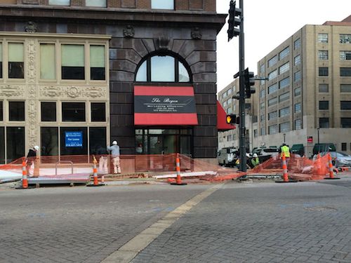
The rebuilt of Tucker from Washington to Cass is nearly complete, traffic in both directions has been open for a while now. However, crews are still working to finish the last bit of work — the NW corner of Tucker & Washington.

caption
The Washington side of The Bogen
caption
The Tucker side

Both sidewalks are being replaced as part of the project. But these sidewalks are far more complicated because of how the building was built in 1901. Like a number of other buildings downtown, the basement was allowed to extend past the property line, under the public sidewalk.  This comlicates matters greatly when replacing sidewalks. Sidewalks usually rest on compacted dirt but here people park their cars under the sidewalk.

It looks like this corner will be done and the barriers removed just before the new Stan Musial Veterans Memorial Bridge opens to vehicular traffic on Sunday February 9th.

Here’s a couple of prior posts on the Tucker project:

— Steve Patterson


Advertisement


[custom-facebook-feed]

Archives

Categories

Advertisement


Subscribe