Home » Planning & Design » Recent Articles:

Potential Development Sites Along Proposed Streetcar Line, Part 1: Olive 15th-16th

The proposed streetcar from St. Louis’ central business district (CBD) to the Central West End (CWE) along Olive/Lindell is moving forward. Regular readers know I’m a streetcar advocate because of how it can increase development activity in a way no bus route ever can. I thought I’d take a close look at potential sites along the proposed route, starting with the area nearest my loft.

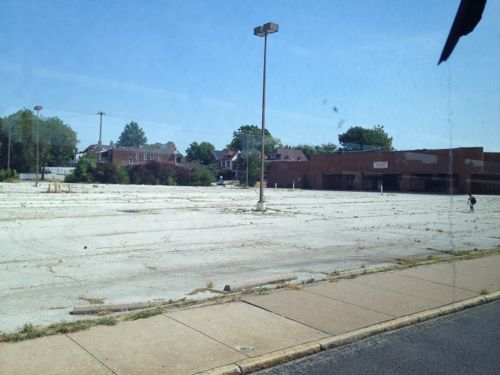
The block on the north side of Olive between 15th and 16th is nothing but two surface parking lots.
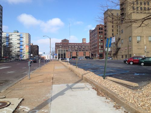
Looking west from 15th Street
Looking west from 15th Street, YMCA at right

The larger lot with entrance on 15th serves the building the occupies the block to the east. This building contains the administrative offices for the St. Louis Public Library and the Confluence High School. That building contains parking underneath as well as some surface parking within that block. The library owns the building and this surface parking lot.

The surface lot, shown above, doesn’t get much use. Once the streetcar line starts running there won’t be as much need for automobile parking, hopefully the library can sell the large surface overflow parking lot to a developer for new construction. This is currently subdivided into 4 parcels with addresses 1501 Olive, 1507 Olive, 1509-1529 Olive, and 1527 Olive with a total area of 26,964sf or 0.62 acres. See map.

The west end of the block is a smaller privately-owned public surface parking lot, legally divided into two parcels with addresses 1531-1533 Olive and 1535-1537 Olive. The total area of these two parcels is 11,676sf or 0.27 acres. Combine all six parcels owned by two entities and you have 38,640sf or 0.89 acres.
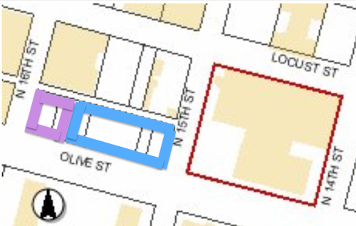
Purple is the smaller privately-owned lot, blue the lot owned by the library and the red outlines the building with library offices and charter high school.

The only structures on this city block are The Campbell House Museum and the 10-story YMCA. The 100 upper floor apartments have been vacant for at least 5 years now, hopefully a streetcar line will get someone interested in taking on the project. Other buildings in the area range from 1-10 floors, but most are greater than 5.

A stop is highly unlikely at 15th because the streetcar line will have a major connection at 14th, but I’d like another stop at 16th or 17th.  Even if the next stop isn’t until 18th or 19th I can see this block filled in with apartments and/or condos along with new ground-floor restaurant/retail space.

— Steve Patterson
 

Vacant Service Station on Shaw Has Great Potential

About 25-30 years about ago the now-defunct magazine Metropolitan Home had an article on an old service station being converted into a private residence, if I recall it was a contest winner located in Dallas. Since then I’ve been hooked on the reuse of these structures.

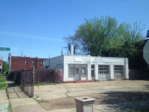
In February I posted about a formerly dumpy service station on Tower Grove that is now a trendy restaurant. Recently I passed by another vacant service station just perfect for a similar transformation. I’d passed by this same location many times before without noticing anything other than its sad condition. This time I envisioned another restaurant with a patio out front.

The former service station at 4175 Shaw Blvd is located just a block from the Missouri Botanical Gardens, click image for map.

Some of you might say no market exists for food establishments in the area but no doubt that was said before Olio, Shasha’s on Shaw, and Mama Josephine’s opened.

I’d love to see this building get a new life as a restaurant, coffeehouse, or perhaps a plant nursery/cafe.  I don’t know the owner’s intentions, or the potential environmental issues, but I know from a purely design perspective the potential is high.

— Steve Patterson


Omni Majestic Hotel Protects Pedestrian Route

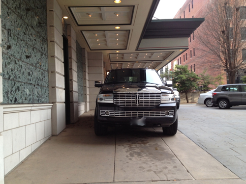
In February I posted about a problem I had observed, see Bollards Needed to Protect Pedestrian Route Into Omni Majestic Hotel on Pine Street. I contacted the manager of the hotel about the problem, along with a link to my post. 

ABOVE: The problem is this leaves very little of the walkway for pedestrian use.
One of the five pics I used to illustrate the problem of vehicles parking on the pedestrian route.

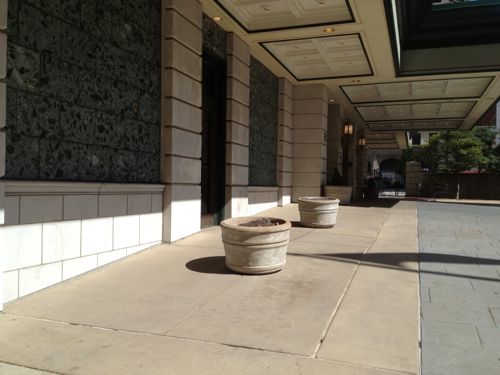
I’m happy to report the hotel has corrected the situation in a very simple manner: two planters.

Two simple planters tell motorists this isn't a parking space.
Two simple planters tell motorists this isn’t a parking space.

Thank you to the Omni Majestic for taking action to protect the pedestrian route to your hotel.

— Steve Patterson


Coming Soon to Kingshighway & Delmar: More Low-Density Sprawl

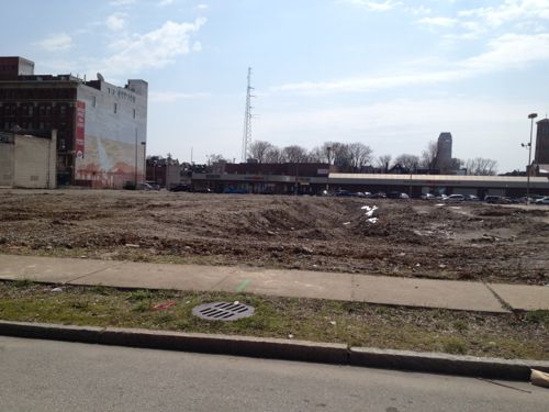
The site of the former National/Schnucks at Kingshighway & Delmar, long vacant, has now been cleared for new development. I’ve viewed the site as an opportunity to build a dense urban project, ideally connected with a Delmar extension of the future Loop Trolley. But current plans may delay dense development of the 4+ acre site for at least the next 20-30 years.

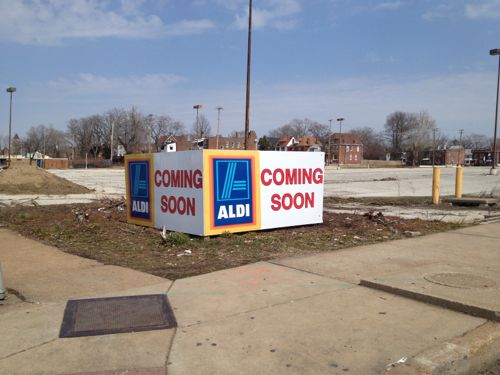
Former grocery store building has now been razed.
Former grocery store building sat back at the east end of the site
The long-vacant building was recently razed.
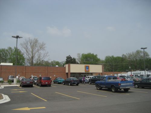
Discount grocer Aldi has announced a new location here.
Discount grocer ALDI has announced a new location here.

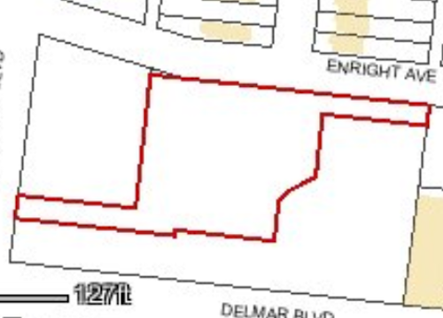
But ALDI doesn’t need over 4 acres! Looking at city records online I see The Roberts Brothers has divided the site into three parcels, with ALDI buying one of the three.

Outline of the parcel Aldi purchased.
Outline of the parcel ALDI purchased with Kingshighway on the left, Delmar on the bottom.

The boundaries of the three parcels is intriguing, my guess is so all three can have automobile  entrances facing Kingshighway, or at least a Kingshighway address.  This new store will be part of three recently announced locations also including Creve Coeur & Des Peres (source).

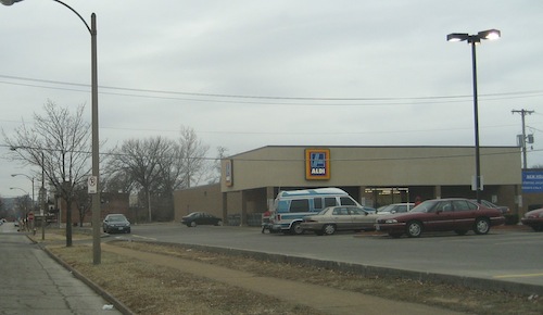
My assumption is this Kingshighway & Delmar location will replace the ALDI less than a mile to the north at Kingshighway & Page (1315 Aubert).

The Aldi at 1315 Aubert (Page & Kingshighway) was built in 1991.

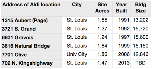
Below is a look at a few ALDI locations in the area, showing size of parcel, year built, and the building size:

Comparison of a few select Aldi locations
Comparison of a few select ALDI locations

The most recently completed ALDI on the list above is the 7701 Olive location. I visited that ALDI in May 2006, shortly after it opened.

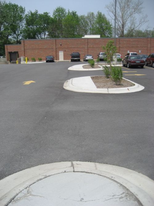
View from the Olive auto entrance
A route is provided from Olive but it is not ADA-compliant.
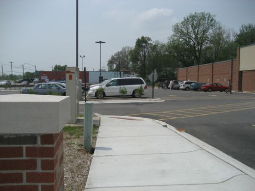
An ADA-compliant route is provided off North and South

This is how ALDI builds US locations from coast to coast. For example, in late 2010 a blogger noted the design for a dense Washington DC neighborhood (see Terrible Aldi design shows need for new parking zoning). As with so many retailers, they’ll do the cheapest design they can, barely meeting minimum standards. If we want/expect better we must demand better — raising the minimum. Retailers will meet the improved standard as long as they can get sales & profit growth.     ALDI does have a few urban locations, but only in super-dense places like Queens, NY.

And before anyone says ALDI and Trader Joe’s are part of the same company let me clarify their relationship.

The [ALDI] chain is made up of two separate groups, Aldi Nord (North – operating as Aldi Markt), with its headquarters in Essen, and Aldi Süd (South – operating as Aldi Süd), with its headquarters in Mülheim an der Ruhr, which operate independently from each other within specific areas.

[snip]

Both Aldi Nord and Aldi Süd also operate in the United States; Aldi Nord is owner of the Trader Joe’s chain while Aldi Süd operates as Aldi. (Wikipedia)

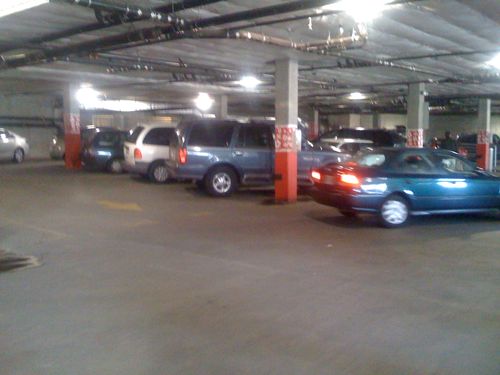
Thus the ALDI we see in the US is NOT related to our Trader Joe’s stores. Another difference between our ALDI stores and our Trader Joe’s is the latter is willing to go compact in dense, walkable areas. For example, the Trader Joe’s I visited in 2009 located at 1700 E Madison St, Seattle, WA.  The store is located on the ground floor with sidewalk entrance, a level of structured parking over the store and four levels of housing over that.

Garage of the Trader Joe's in the Capital Hill neighborhood of Seattle
Garage of the Trader Joe’s in the Capital Hill neighborhood of Seattle

Madison St. in Seattle still has low-density development, like the gas station across from the Trader Joe’s, but one property at a time it is getting more urban. As it gets more urban it attracts more people, increasing the need to be more urban.

Back in St. Louis, we do the opposite. We continue to build low-density sprawl, then scratch our heads wondering why more people don’t walk, use transit, or why our population declines. I’m not suggesting development patterns are the reason for our population decline in the past, but it is a factor today.

A single story ALDI surrounded by surface parking on this corner is totally inappropriate given the context to the east and south.

— Steve Patterson


Wheelchair Users Unable To Pay Parking Fee With Credit Card

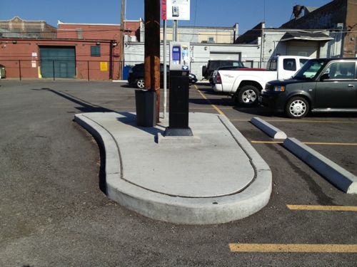
Just weeks before Tishaura Jones was sworn into the office of St. Louis Treasurer I posted about a problem with a city-owned parking lot on Olive (see Wheelchair Users Unable To Pay Parking Fee In City Parking Lot). In that post I showed how disabled drivers that use wheelchairs would be unable to pay the central machine.

ABOVE: However, those disabled drivers that use a wheelchair are unable to reach the payment machine because no ramp up was provided.
Disabled drivers that use a wheelchair are unable to reach the payment machine because no ramp up was provided.

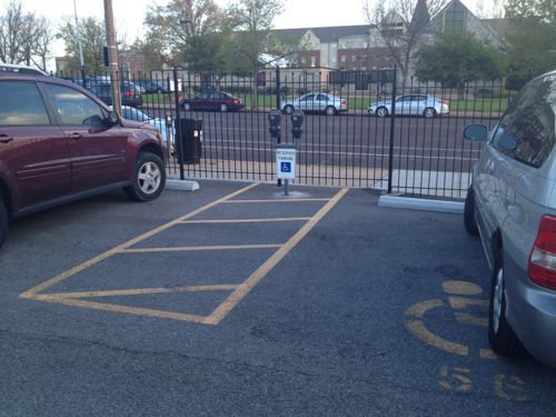
At the time the city said they planned for the two disabled spaces to be free of charge, so disabled users didn’t need ADA-compliant access to the machine. The other night I noticed the city installed two old fashioned parking meters between the two disabled spaces.

The city's solution was two meters for the disabled spaces.
The city’s solution was two meters for the disabled spaces.

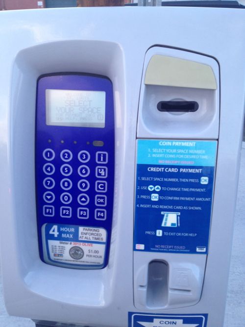
Problem solved, right? Wrong! This means those parking in the two disabled spots must carry coins to feed the parking meter while everyone else gets the option to pay by coin or credit card.

The pay-per-space machine accepts coins and credit cards, but not bills.

The city made an error and didn’t consider disabled users. Then in trying to fix their error on the cheap they created a problem of inequality.
— Steve Patterson


Advertisement


[custom-facebook-feed]

Archives

Categories

Advertisement


Subscribe