Home » Politics/Policy » Recent Articles:

Proposed Alterations To Soldiers’ Memorial Should Take These Issues Into Consideration

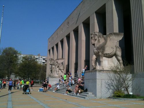
Soon the Missouri History Museum is expected to show final designs for two blocks of the Gateway Mall bounded by 14th, Pine, 13th, and Market — Soldiers’ Memorial & Court 0f Honor. A big unknown is Chestnut Street which runs one-way Eastbound between the two blocks.
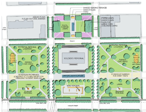
The Gateway Mall Master Plan calls the area around Soldiers' Memorial the "Civic Room"
The Gateway Mall Master Plan calls the area around Soldiers’ Memorial the “Civic Room”
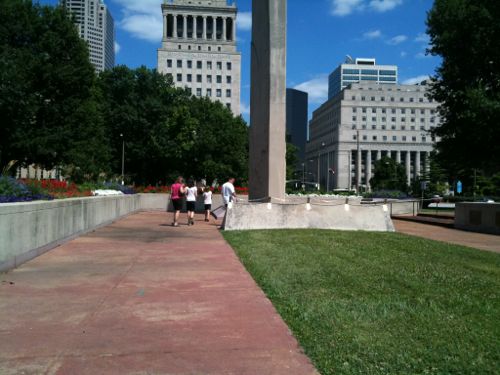
St. Louis' Court of Honor, June 2010
St. Louis’ Court of Honor, June 2010
Soldiers' Memorial, 2011
Soldiers’ Memorial, 2011

Since the Slay administration chose to abandon the Gateway Mall Advisory Board, I don’t know what to expect in the way of review for compliance with the master plan, public input, stakeholder input, etc.

Here are my primary areas of concern:

  • Festivals
  • Street grid, traffic flow
  • Linear hallway along Gateway Mall

Let’s examine each:

FESTIVALS

This might be moot, since the Slay administration ran off great events like the Taste of St. Louis in favor a concert series that never happened:

After a year without major summer festivals in downtown St. Louis, the city may have finally had enough. On Black Friday the mayor’s office announced that it had ended its agreement with Los Angeles-based International Creative Management (ICM) to produce a promised but never held “Summer Rocks” series on the Gateway Mall.

That controversial deal, spearheaded in part by developer Steve Stogel (president of Clayton-based DFC Group) and approved by the city via Festival Reservation Bill 328, blocked out a downtown area from Union Station to City Hall from May to September 2015, and would have continued to do so for another nine years (and possibly more). The non-compete clause had already forced out local festivals like Taste of St. Louis, Ribfest and Bluesweek. (RFT)

The Gateway Mall Master Plan calls for this area to be the city’s main space for festivals. It calls the blocks including, and around, Soldiers’ Memorial the Civic Room:

The Civic Room will create a large uni?ed space well-suited for civic events, markets, festivals and concerts. In order to achieve this, it is anticipated that Chestnut Street would be closed incrementally over time, beginning with temporary closures for festivals, and ultimately consideredfor permanent or seasonal closure, though still allowing emergency and service vehicle access.Chestnut Street should still be hard surfaced with a paving different than surrounding areas, to accommodate tents and other services necessaryfor festivals. Locations for performance stages and cultural or art annexes should be provided to further de?ne the civic character of the space and create attractions to activate the Mall.

Before Citygarden was built a few blocks to the East, that area was used for large events as well — the Taste of St. Louis started where Citygarden is now. With this new agreement, the Missouri Historical Society (MHS) will have discretion for the use of the middle of the Civic Room festival area:

Although MHS will not host concerts or festivals that do not meet with the mission of Soldiers Memorial, it is willing to collaborate with festivals held in its neighboring parks for something that is mission driven. For example, MHS might have a wreath laying ceremony during Pride on the Soldiers Memorial grounds for LGBTQ members of the military. (FAQ)

Personally, I’d like to see large festivals held elsewhere, perhaps in & around the new Kiener Plaza?  Kiener is closing next month for a 12-14 month makeover, the median will be removed from Market Street.

STREET GRID, TRAFFIC FLOW

I never liked the master plan’s suggestion to eventually close Chestnut St. When you close one block of a street that kills activity on the rest of the open blocks before & after the closure. I’d like to see Chestnut & Pine return to two-way traffic West of Tucker. Then they’d feel like neighborhood streets again rather than very long highway on/off ramps.
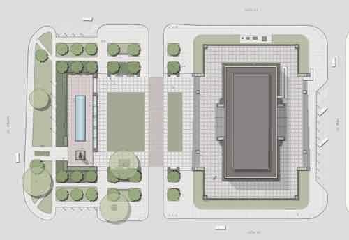
Missouri History Museum drawing from Fall 2015 shows what appears to be a single lane. Final design may be different.

The problem with this draft is it doesn’t show the surrounding context. What about the blocks to the East West, & North?  What is the whole concept for all of these blocks? It doesn’t need to be built by the history museum but all needs to be part of the design process — so it’ll all work eventually. Looks like they’re designing this in isolation — an island. Chestnut is two lanes with diagonal parking to the East & West — lanes, crosswalks, curb ramps need to align. Without showing surrounding existing conditions it is hard to determine if these have been considered. Most likely they haven’t.

The new parking-protected bike lane on Chestnut is an issue, but it should’ve been on Olive. That would’ve required building accessible bus stops in the parking lane — Chestnut was picked for the bike lane because it was easier than Olive.

HALLWAY

One of the best parts of the Gateway Mall Master Plan is the hallway concept — a wide tree-lined sidewalk along the North side of Market St.
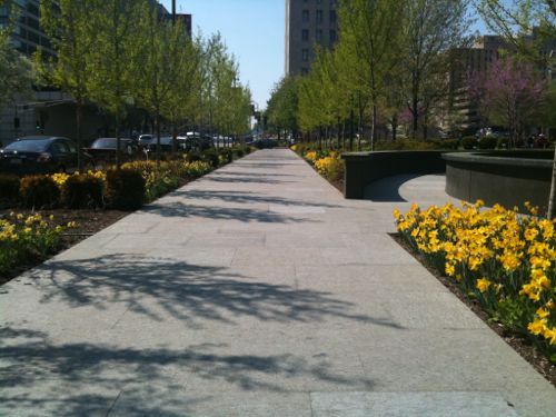
The Gateway Mall master plan calls for this "hallway" to run from Broadway to 20th
The Gateway Mall master plan calls for this “hallway” to run from Broadway to 20th

Their preliminary design doesn’t show the hallway. So far we only have the two blocks along Citygarden.

— Steve Patterson
 

Readers Split on MSD Plan To Raze Vacant Buildings To Reduce Water Runoff

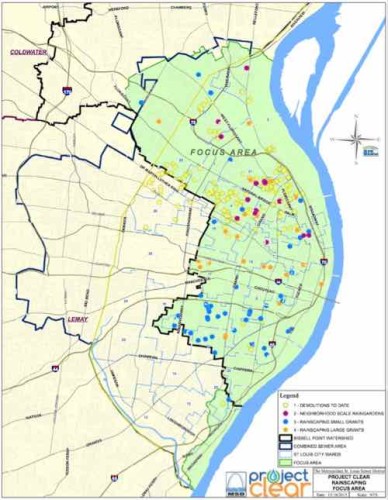
Focus area, click image to view larger PDF

In the recent non-scientific Sunday Poll readers were split on MSD’s plan to raze vacant buildings to reduce water runoff.

  • Support side 18
  • Oppose side 17
  • Neutral+Unsure 7

Below is the breakdown:

Q: To reduce water runoff, the Metropolitan Sewer District (MSD) plans to raze vacant buildings. Oppose or support?

  • Strongly support 8 [19.05%]
  • Support 3 [7.14%]
  • Somewhat support 7 [16.67%]
  • Neither oppose or support 5 [11.9%]
  • Somewhat oppose 2 [4.76%]
  • Oppose 3 [7.14%]
  • Strongly oppose 12 [28.57%]
  • Unsure/No Answer 2 [4.76%]

As you can see, the “strongly oppose” answer got the biggest response. Supporters weren’t as enthusiastic. Much of the demolition would happen in neighborhoods struggling to remain relevant.

While it could take several years to spend down the money, even the longest spending scenario would amount to a near doubling of St. Louis’ demolition budget. And areas where MSD sees the most benefit in terms of runoff and watersheds also are the areas – primarily in north St. Louis – where the city’s vacant properties are concentrated. 

Those areas are part of the Bissell watershed, where the Environmental Protection Agency has told MSD to better manage stormwater. (Post-Dispatch)

Each time a building is razed it gets harder to convince remaining owners to invest in their properties, to get residents to stay. Still, I need to read more about MSD’s Project Clear.

— Steve Patterson


St. Louis Abandons Public Review Process for The Gateway Mall

In 2010 I was appointed to represent the 6th ward on the newly formed Gateway Mall Advisory Board (GMAB). The idea was to mirror how Forest Park is managed — a conservancy made up of the wealthy to help raise money for projects and an advisory board to let the Parks Dept know if proposed projects complied with the Master Plan, or not. Initial terms were staggered, with three year terms thereafter.

From a March 12, 2010 press release:

Named to the Gateway Mall Conservancy Board were Peter Fischer, GatewayFoundation; Robert Archibald, Missouri Historical Society; Steve Cousins, ArmstrongTeasdale LLP; John Ferring, Plaze, Inc.; David Mesker, retired, A.G. Edwards; EmilyRauh Pulitzer, Pulitzer Foundation for the Arts; Kitty Ratcliffe, St. Louis Convention andVisitors Commission; Henry S. Webber, Washington University; Josephine Weil,Community Volunteer; and Patricia Roland-Hamilton as Executive Director.

Also announced today was the formation of the Gateway Mall Advisory Board, a groupof stakeholders responsible for monitoring the implementation of the Gateway MallMaster Plan and providing ongoing community input about the Gateway Mall. Itscomposition and responsibilities are outlined by City ordinance.

Things went downhill quickly, my post from August 2013: Gateway Mall Still Unloved, Conservancy Resigned, Advisory Board Kept In Dark..  At this point I’d been pressing then Parks Director Gary Bess to initiate the process to appoint myself and others whose terns expired in March 2012. See original list here.

In October 2013 Gary Bess handed out a list at the last GMAB meeting showing the terms of myself and others hadn’t yet expired — see it here. The best word to describe this lists is forged. My original term expired in March 2012 but this new document showed it expires in March 2017 — again the appointments are for three years.  Some on this list now showed up with terms expiring in 2017 — impossible since it was just 2013.  The next month I emailed Bess and others on the GMAB list to let them know of the discrepancy. Bess was going to look into it.

This attempt to create a false record didn’t surprise me, in the 3+ years we did meet, I had to constantly remind Bess of the language in the enabling ordinance and our adopted bylaws. Last year Bess retired from the city and became the St lotus county director of parks, see St. Louis County Parks Director double dipping at taxpayer expense.

On December 31, 2015 the private nonprofit Gateway Mall Conservancy was administratively dissolved by the Missouri Secretary of State. Despite being required by ordinance, the GMAB also no longer exists. Our terns all expired, nobody was reappointed or replaced with new appointees. In January 2014 I was asked by Parks & 6th Ward Alderman Ingrassia if I was willing to be reappointed, I said yes to both and submitted the form to reappointed to a public board. Nothing happened.

The Gateway Mall Master Plan calls the area around Soldiers' Memorial the "Civic Room", click image to see section
The Gateway Mall Master Plan calls the area around Soldiers’ Memorial the “Civic Room”, click image to see section

Soon the History Museum will show their plans for two blocks of the “Civic Room” which includes Soldiers’ Memorial but the public body established by ordinance to review proposals no longer exists. In 2010 I had a feeling the city would abandon the Gateway Mall, master plan, and the public review process — I just didn’t think it would happen so quickly.

— Steve Patterson


Small Bar Exemption From Smoking Law Ends Saturday (UPDATED)

Five years ago, on January 2 2011, the City of St. Louis went smoke-free — with the exception of casinos and existing small bars that met certain conditions. Since then, some small bars that qualified for the exemption opted to go smoke-free.

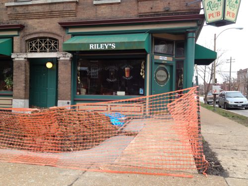
During the 2007 Spring elections I attended a 6th ward campaign event at Riley’s Pub, 3458 Arsenal — it was so full of smoke I could hardly breathe. Back then the space out front was just an expanse of concrete and a couple of railroad tie planters — see on Google Street View. Due to the small size, Riley’s Pub qualified for an exemption — indoor smoking could continue. Not long after the smoking ban went into effect, Riley’s began turning the space out front into a proper patio.

Patio construction underway in December 2011

I’ve seen the new patio, but not photographed it. Even though it is finished, smoking is still allowed inside — until Saturday that is. A few days ago Riley’s Pub posted the following on their Facebook page:

If you don’t like to be around the smoke, you soon will be able to breathe easier at Riley’s. But if you are a smoker, consider stopping by New Year’s Eve or Day for a few last drags in the civilized indoors. 

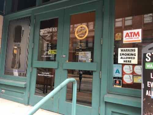
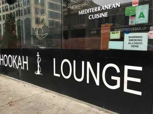
Unlike Riley’s, two downtown exempt bars don’t mention the expiration of the exemption. I checked the website & Facebook page of Stanley’s Cigars — no mention.   Same for the website & Facebook page of Nara Cafe and Hookah Lounge.

Stanley's Cigars
Stanley’s Cigars
Nara Cafe & Hookah Lounge

I think many places will be caught off guard — even though they’ve had five years to prepare. Will they fight the exemption expiration? Will they pay fines? Decide to close rather than change? We will soon find out.

Please have a safe New Year’s Eve, see you again 8am Sunday morning for the first poll of 2016.

UPDATE 12/31/15 @ 11:20am:

The situation changed after I wrote this post:

Trophy Room owner Herbert Krischke filed suit on Christmas Eve, asking a judge to block the city from enforcing the ordinance or declare it unconstitutional. In part, the suit argues that the law “grants a special or exclusive right, privilege or immunity” to casinos such as Lumière Place, which would keep its exemption. Bar owners say that sets a double standard.

Dowd issued the restraining order Wednesday because he wanted to schedule a full hearing on the matter, which has been set for 10 a.m. Jan. 11, according to Thom Gross, court spokesman for the 22nd Judicial Circuit. Krischke and other city bar owners believe they’ve found a loophole to the existing law. (Post-Dispatch)

I’d like the courts to invalidate the exemption for gambling areas.

— Steve Patterson


Rapid Urbanization of Dardenne Creek Watershed in St. Charles County Has Dramatically Increased Runoff

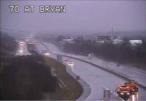
From a MoDOT camera, trucks in lower right used to close I-70

Record rainfall has resulted in flooding in the region, notably St. Charles County. On Sunday a major interstate highway was closed in both directions:

Both directions of Interstate 70 remain closed in St Charles County near Route 79 in St Peters due to rising flood waters from the Dardenne Creek. The eastbound lanes closed around noon Sunday, December 27 and the westbound lanes closed around 2:30 p.m.

It is expected that both the eastbound and westbound lanes will remain closed for Monday morning rush hour traffic.

Motorists who need to use eastbound I-70 in St Charles County can exit at Interstate 64 eastbound to Route 364 eastbound. Route 364 connects to Interstate 270 in St. Louis County and from there motorists can reconnect to Interstate 70. Westbound I-70 travelers will have to exit the highway at Route 94 in St Charles. They can take westbound Route 94 to westbound I-64 to connect back to I-70. (MoDOT)

The Dardenne Creek watershed flooded onto the interstate:

A watershed is an area of land where the runoff from rain or snow will ultimately drain to a particular stream, river, wetland or other body of water. There are nine major watersheds in the St. Louis region which drain into the Mississippi River and the Missouri River. Nested within these watersheds can be found smaller watersheds of creeks or streams and those segments of land which drain directly into the nine major watersheds. The following sections delineate the watersheds in the St. Louis region, discuss watersheds and watershed based natural resource planning and describe the actions the general public and local governments can take to improve water quality in their watersheds. (East-West Gateway Council of Governments)

While the record rainfall is big factor in the flooding, we can’t continue to ignore the role of urbanization plays. The better term, however, is suburbanization. Low density development with lots of rooftops, parking lots, and wide roads to connect it all. Coupled with dramatic population growth, too much of the county is paved over.

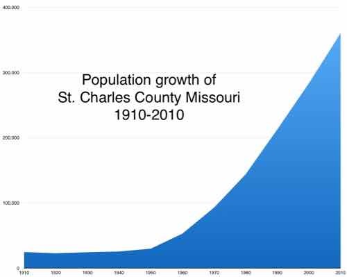
Here is the population of St. Charles County, per decade, with the percentage of growth from the previous.

  • 1910 24,695 0.9%
  • 1920 22,828 ?7.6%
  • 1930 24,354 6.7%
  • 1940 25,562 5.0%
  • 1950 29,834 16.7%
  • 1960 52,970 77.5%
  • 1970 92,954 75.5%
  • 1980 144,107 55.0%
  • 1990 212,907 47.7%
  • 2000 283,883 33.3%
  • 2010 360,485 27.0%

Below is the visual:

Graph made from figures on Wikipedia, click image to view page.

Flooding is an unintended consequence of this growth — all those parking lots add up! Had they planned development to be more compact and respectful of the watershed the current flooding wouldn’t be as extreme. Two geography students looked at this in a paper published in 2009: IMPACTS OF URBANIZATION ON SURFACE RUNOFF OF THE DARDENNE CREEK WATERSHED, ST. CHARLES COUNTY, MISSOURI.

Some quotes:

Urbanization, a common land use/land cover (LULC) change in suburban areas, has become a significant environmental concern in the United States. Urban areas are continuously increasing at an alarming rate (22.7 ha per hour in 1982–1997) as reported by the U.S. Environmental Protection Agency (EPA) (USEPA, 2009). Although it provides enormous social and economic benefits, urbanization creates a significant amount of impervious surface by converting vast area of croplands, for- ests, grasslands, and wetlands into urban uses. The conversion alters natural hydro- logic processes and results in profound environmental consequences within a watershed, such as increasing the volume and rate of surface runoff and reducing ground water recharge (Carter, 1961; Andersen, 1970; Lazaro, 1990; Moscrip and Montgomery, 1997; Tang et al., 2005). Expanded impervious cover also reduces runoff lag time and increases the peak discharge of stream flow, resulting in larger and more frequent incidents of flooding (Field et al., 1982; Hall, 1984) and subse- quent increases in the scouring and incision of streams (Leopold, 1973; Booth, 1990; Doyle et al., 2000). Furthermore, the increase of impervious surface area degrades water quality of the stream, which is a major transporter and concentrator of pollutants (such as nutrients, heavy metals, and pesticides) in runoff and sedi- ments (Schueler, 1995). Percent impervious surface area in a watershed has been used as an important indicator of the ecological and environmental conditions of an aquatic system (Schueler, 1995; Arnold and Gibbons, 1996).

The Dardenne Creek watershed in St. Charles County, a suburb of St. Louis, Missouri, has experienced significant urban expansion in past decades. Events such as road overtopping in 2005 as a result of the highest flood level recorded since stream gages were installed in 1999 (U.S. Army Corps of Engineers, 2007) have focused public attention on the need to understand how the pattern and magnitude of past LULC change have impacted runoff, and how future development and miti- gation might change watershed hydrology. The aim of the work reported here was to provide a quantitative assessment of the impact of past urbanization on surface runoff, and a baseline calibrated model for future efforts to assess potential hydro- logical impacts of new urban development and LULC change.

In the lower portion of the watershed, both forests and agricultural lands decreased from 1982 to 2003, although the rate of decrease became lower after 1987. Corresponding to the decrease of these two LULC classes, urbanization was apparent between 1982 and 2003. In 1982, urban areas only covered 7.4% of the area. After that, they increased at approximately 2.1% per year and became one of the dominant classes in 2003 (50.5%) (Figs. 3B and 3D). LULC change in the upper portion of the watershed was less dramatic (Figs. 3C and 3D) because of its remote location from the metropolitan area. Forest cover in the upper portion was higher than in the lower portion. Forest cover decreased 11.2% from 1982 to 1987 and tended to be stable in the following years. Different from the lower portion, agricultural lands increased from 1982 to 1991, a possible correspondence of deforestation. Agricultural lands decreased after 1991 at a much lower rate than that in the lower portion. Urbanization in the upper portion was limited. Urban areas were only 0.4% in 1982 and gradually increased to 10.9% in 2003. 

Results indicated that the watershed experienced rapid urbanization from 1982 to 2003. Urban areas increased from 3.4% in 1982 to 27.3% in 2003 in the whole watershed. Urbanization dominated in the lower portion of the watershed and gradually migrated to the upper watershed due to the proximity to the metropolitan area of the city of St. Louis. As a direct result of the urbanization from 1982 to 2003, the long-term surface runoff increased >70% for the whole watershed (>95% and >48% in the lower and upper portion of the watershed, respectively). The runoff increase was highly correlated with the percentage of urban areas (R2 > 0.90). Cou- pled with significant flooding events in 1993 and 2005, this work helps raise aware- ness of the actual scale of hydrologic impacts of urbanization in this particular watershed, and provides a simple calibrated tool for local planners to use in assess- ing potential impacts of future development and mitigation activities. More generally, such case studies provide important insight both into the scale of impact of complex land-use change and into approaches that can be used to evaluate, plan, and manage watersheds.

So what can be done about it now, isn’t it too late? No!

I’ve talked about Retrofitting Suburbia before. Architect Ellen Dunham-Jones suggests, in her TED talk, we can daylight creeks, rebuild wetlands, etc.  The solution is to literally urbanize some suburbanized areas, while returning others to rural, wetlands.

However, I seriously doubt the conservative electorate in St. Charles County is willing to do what is necessary. Flooding will likely continue.

— Steve Patterson


Advertisement


[custom-facebook-feed]

Archives

Categories

Advertisement


Subscribe