Home » Transportation » Recent Articles:

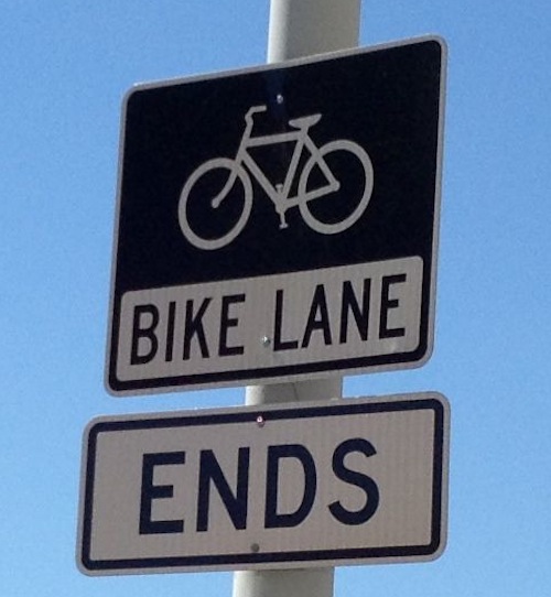
Bike Lanes: Do Them Right Or Don’t Bother

Bike lanes, when done right, can greatly assist the users by guiding them and making motorists more aware.  Done wrong, the cyclist often ends up in the wrong position at  an intersection. Most of the time in St. Louis our bike lanes are flawed, especially at intersections.

ABOVE: Sign posted on westbound Lafayette Ave just before Jefferson Ave.
Sign posted on westbound Lafayette Ave just before Jefferson Ave.
Eastbound on Olive just before Jefferson the bike lane becomes part of the right turn lane

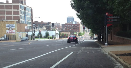
In the situations above most people on bikes will incorrectly shift to the right so they’ll be to the right of right turning vehicles — not good for the cyclists or motorists. Bikes are vehicles so those continuing straight through the intersection need to be positioned to do that. Above, that means being on the white line separating the through lane from the right turn lane.

In cities where they do more than lip service bike lanes are more helpful.

The places where cars are allowed to cross bike lanes for right turns are very clear in Portland OR.
The places where cars are allowed to cross bike lanes for right turns are very clear in Portland OR. 2009 photo

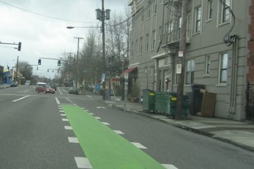
In the above example from Portland, even the most amateur cyclist will stay in the proper position on the roadway to continue forward. Motorists will be able to get into the right turn lane and turn without conflicting with the cyclist.

Colored bike lanes

Colored bike lanes have been a feature of bicycle infrastructure in the Netherlands (red), Denmark (blue), France (green) and many other countries for many years. In the United Kingdom, both red and green pigments are used to delineate bike lanes and bike boxes. However, in this country their use has been limited to a few experiments in just a handful of locations. The most extensive trial took place in Portland, Ore., where a number of critical intersections had blue bike lanes marked through them and the results were carefully monitored. The results of the study, conducted by the City of Portland Office of Transportation and the UNC Highway Safety Research Center, can be found here.

The Portland photo was taken about a decade after their study. Portland cyclists must still be skilled to be able to make left turns, for example.

— Steve Patterson


‘Schoemehl Pots’ Traffic Circles Roundabouts

Vince Schoemehl served as mayor for three 4-year terms, from 1981-1993. He’ll be remembered in history for a number of things, but perhaps mostly for giving us “Schoemehl Pots,” concrete sewer pipe sections filled with dirt.

Schoemehl pots used in their traditional role of messing up the street grid.
Schoemehl pots used in their traditional role of messing up the street grid. N 22nd St & Newhouse Ave, click to view in Google Maps

Lately they’ve been used in a way that calms traffic while keeping the grid intact: the Schoemehl Pot Roundabout Traffic Circle!

Utah St & Arkansas Ave, click image to view in Google Maps
A more permanent roundabout at Louisiana & Osceola, click image to view in Google Maps
A more permanent traffic circle at Louisiana & Osceola, click image to view in Google Maps

The roundabout traffic circle shown at the bottom takes a considerable investment compared to a few sewer pipes filled with dirt, but the results are dramatically different too.  I just know I’ve never seen a Schoemehl pot installation that didn’t make me cringe.   Can we stop using them to block streets and create makeshift roundabouts traffic circles?


Tucker Boulevard Replacement Project Nearing Completion

July 12, 2013 Downtown, Featured, Planning & Design, Transportation Comments Off on Tucker Boulevard Replacement Project Nearing Completion

The last bit of the old Tucker Blvd road surface, from Cass to Washington Ave, is now rubble. The last of the former rail tunnel was filled in a couple of months ago, now all that needs to be replaced is the last of the small area that didn’t have a tunnel under the roadway.

Looking north at Tucker Blvd from Washington Ave. This is the last part of the old road surface to be removed.

In addition to the road surface, the adjacent sidewalk for these last couple of blocks. Auto traffic is now open from Cass to Washington Ave in both directions, though constrained on the south end.

— Steve Patterson


How To Use An Inverted-U Bike Rack

Bike racks come in all shapes and sizes, but my preference is the basic “inverted-U” rack. Very simple, easy to use.

Here’s a perfect example:

This bike is properly placed next to the Inverted-U rack, the rack helps support the bike. .
This bike is properly secured to the Inverted-U rack in two points, helping support the bike. Looks like a fixed gear bike, nice!

And here’s how to NOT use an inverted-u bike rack:

This bike is not properly placed, it is taking up extra space on the sidewalk and could tip over.
This bike is not properly secured, the bike is extended beyond the rack blocking the path the driver of the red car might use. Also being locked in one point, it is a target for theft and at risk of tipping over.

So if you’re a cyclist and you use an inverted-u rack please place your bike so it is centered on the rack, using two locks so it doesn’t get stolen.

Bonus tip: If I can see your forehead when you’re wearing a bike helmet it won’t help you if you crash, cover your forehead.  Click here for pictures on the right & wrong ways to wear a helmet.

— Steve Patterson


Polls: How Would You Expand Modern Streetcar Lines From Proposed Route Into North & South City?

I’m excited about the proposed St. Louis Streetcar, I’m a streetcar fan and the idea of living just a block away from the line has be overjoyed. Like out 20 year old light rail line, the streetcar primarily serves the city’s central corridor — downtown and parts west. North & south St. Louis wouldn’t benefit with the original route. I’ve lived 16 of my 23 years in St. Louis in north (3) and south (13) city, I know what it’s like to see millions spent on transit infrastructure with little personal benefit.

Even living downtown now I use MetroBus way more often than MetroLink, the bus is closer to me and my frequent destinations than light rail.

For the purposes of this post/poll I’ve made the following assumptions:

  • The initial streetcar line will open in 2017, aligned as proposed. 
  • The #70 MetroBus line on Grand will get longer articulated buses.
  • In-street light rail to quickly get north & south county suburbanites to ballgames won’t move forward
  • Modern streetcars are as much about economic development as transportation.

The poll this week is broken into two questions: 1) how would you expand the proposed streetcar line further into north St. Louis from the spur at N. Florissant @ St. Louis Ave. and 2) how would you expand the proposed streetcar into south St. Louis from 14th @ Clark.

Some possible  future expansions for the proposed streetcar line ending at N. Florissant @ St. Louis Ave
Some possible future expansions for the proposed streetcar line ending at N. Florissant @ St. Louis Ave. Grand is shown in yellow.

The north options I’ve listed in the poll are:

  • Cass to MLK to the St. Charles Rock Rd MetroLink station. This goes though areas in need of development, investment, & jobs, but doesn’t go very far north
  • West on St. Louis Ave to Goodfellow. This goes through areas also needing the above but runs through primarily residential areas while crossing major commercial streets.
  • N. Florissant to Natural Bridge, eventually out to UMSL south MetroLink. Natural Bridge is a wide right-of-way, plenty of room for a streetcar in the center.
  • N. Florissant past the cemeteries to Goodfellow. This goes farther north than the other options, possible connections to north county bus/streetcar
Some possible future expansions for the proposed streetcar line south from 14th @ Clark
Some possible future expansions for the proposed streetcar line south from 14th @ Clark. Grand is shown in yellow.

The south options listed all start by going south on 14th from Clark:

  • Chouteau to Broadway to River Des Peres
  • Chouteau to Jefferson to Chippewa to Lansdowne to Shrewsbury MetroLink
  • Lafayette to Tucker to Gravois to Hampton
  • Chouteau to Vandeventer to Southwest to Hampton

Poll questions for both north & south are in the right sidebar. As you can see these vary and cover different parts of the city. Variations in the street network between north & south city plays a role as well.

Please share your ideas for local modern streetcar routes in north & south S. Louis in the comments below.

— Steve Patterson


Advertisement


[custom-facebook-feed]

Archives

Categories

Advertisement


Subscribe