Home » Public Transit » Recent Articles:

Most Bus Stops On A St. Clair County Route Not Designed For Pedestrians

Last week I decided to visit downtown O’Fallon IL so I could see & photograph their old city hall — which is for sale. It is just a 24-28 minute drive from my loft in downtown St. Louis but my husband and I share a car, which he uses has for work. Transit was my best option, but it would be 90 minutes each way. The first half via MetroLink light rail, the second via MetroBus.

The MetroLink stations/platforms are all wheelchair accessible, as are all MetroBus vehicles. The weak link is MetroBus stops. With thousands of stops throughout the region, a transit agency can only do so much to improve municipal/county rights-of-way. I assumed I’d be ok once I reached downtown O’Fallon so I didn’t look ahead at the stops along the way.

But on the bus I began to snap pictures as the bus stopped — in some cases as we went past stops. For those unfamiliar with riding a bus, they don’t stop at every bus stop. If you want off you must pull the cord to let the driver know you wan the next stop. A bus also stops for those waiting to board. Light rail, however, stops at every stop because they’re limited and spaced far apart.  Still, the bus stops are needed because throughout the day each and every stop will likely be used at least once.

Below are some of the images I took from the #12 MetroBus heading East from the Fairview Heights IL MetroLink station to the O’Fallon City Hall. The bus was near seated capacity when we departed the station.
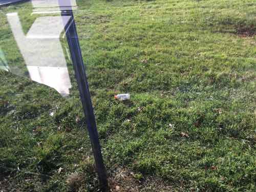
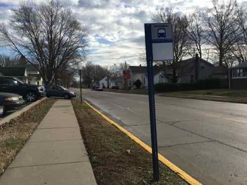
One of the first few stops, just grass -- no sidewalk
One of the first few stops, just grass — no sidewalk
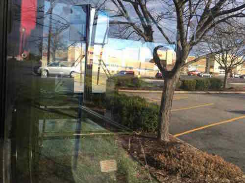
Entering a retail area, the stop isn't accessible at all
Entering a retail area, the stop isn’t accessible at all
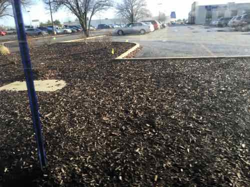
Curbs & mulch at Vatterott College
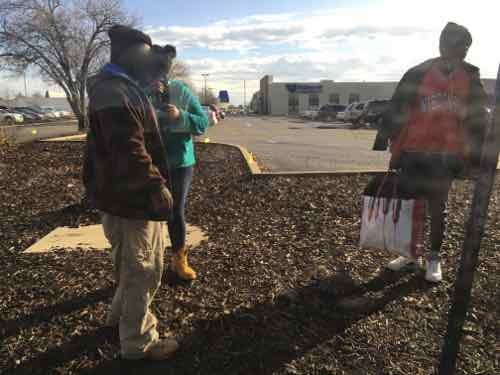
This was one of the busier stops, numerous people got off the bus here.
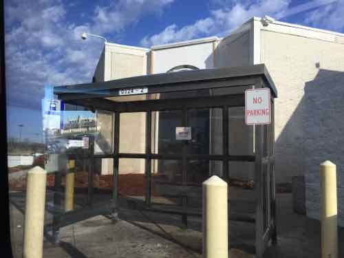
St, Clair Square. No smoking at bus shelter. No access to out parels
St, Clair Square. No smoking at bus shelter. No access to out parcels
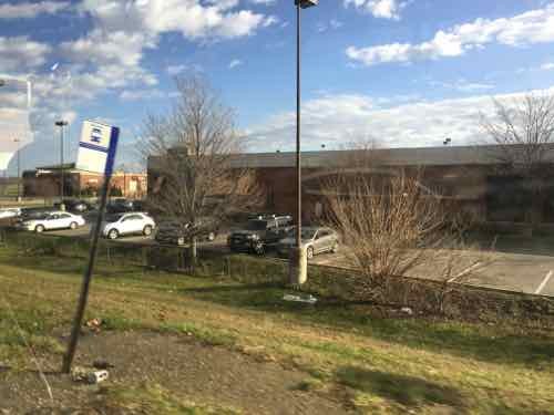
One of the worst stops was for Green Mount Crossing shopping center -- just a little shoulder and worn grass before quickly going downhill into a drainage ditch . Click image to see a list of business
One of the worst stops was for Green Mount Crossing shopping center — just a little shoulder and worn grass before quickly going downhill into a drainage ditch . Click image to see a list of business
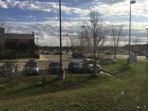
Looking back toward the main automobile entrance.
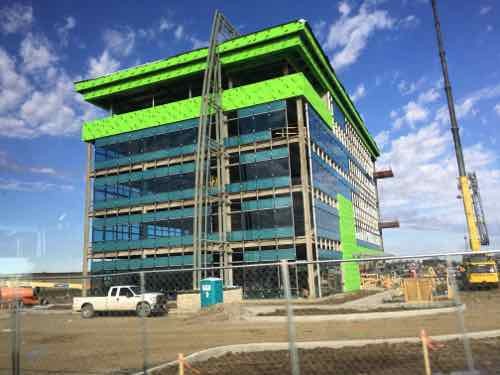
Just to the North we see construction of a new building next to one bus stop.
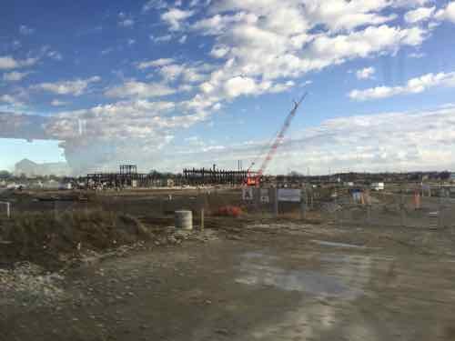
Just around the corner the new St Elizabeth Hospital is under construction. Will they provide an ADA-compliant bus stop and route to front door? How about crossing the street to go the other direction?
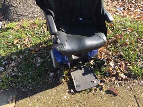
The bus driver tried to let off at the bus stop nearest the city hall, but the ramp stopped short of the sidewalk and the height difference would've gotten me stuck. He had to retract the ramp , pull up to the corner, and let the ramp out again.
The bus driver tried to let off at the bus stop nearest the city hall, but the ramp stopped short of the sidewalk and the height difference would’ve gotten me stuck. He had to retract the ramp , pull up to the corner, and let the ramp out again.
I got around fine, but a missing ramp in downtown O'Fallon forced me into the street until I found a driveway. Washington & Vine
I got around fine, but a missing ramp in downtown O’Fallon forced me into the street until I found a driveway. Washington & Vine
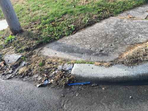
After crossing Cherry 4th I got stuck trying to reach the sidewalk on the West side of Cherry. I had to stand up and pull my front casters onto the sidewalk. All while hoping I don't fall -- because I can't get up on my own.
After crossing Cherry 4th I got stuck trying to reach the sidewalk on the West side of Cherry. I had to stand up and pull my front casters onto the sidewalk. All while hoping I don’t fall — because I can’t get up on my own.

I reviewed the entire route on Google Street View, my stop in downtown O”Fallon was the 82nd stop after leaving the Fairview Heights MetroLink station. We traveled through Fairview Heights, Shiloh, O’Fallon, and likely unincorporated St. Clair County.

If you care to take a look, here’s a link to all the stops. Only a few I’d consider to be ADA-compliant.

Basically this is largely impossible for those of us who are disabled, but a miserable experience for the able-bodied. None of this was built with any consideration for pedestrians — everyone is expected to drive everywhere.  The reality is not everyone can drive. Physical, mental, emotional, and financial issues are some of the reasons why not everyone drives.

Sadly, this is the rule — not the exception. We’ve built so much that’s hostile to pedestrians and impossible for some of us. Tomorrow a similar example from St. Louis County.

— Steve Patterson


St. Louis Shouldn’t Build Light Rail, Modern Streetcar, or Bus Rapid Transit; Rapid Streetcar May Be The Answer

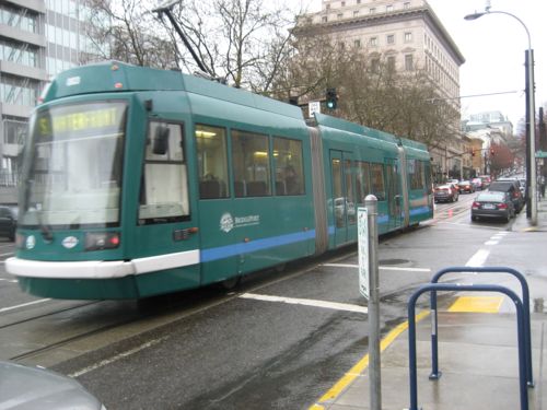
This streetcar in Portland OR is a circulator, not a rapid streetcar

There are several camps in the transit world:

  • Light rail advocates
  • Bus rapid transit advocates
  • Streetcar advocates

These don’t mix — build their classic model or nothing. However, in the last decade a new group has emerged advocating a hybrid of these: The Rapid Streetcar. For example, Portland is looking at Rapid Streetcar for future expansion of its streetcar line.

The rapid streetcar concept aims to combine the best features of streetcars and light rail transit (LRT) to achieve faster commute/travel times than streetcars and lower system costs than light rail. Streetcars are typically designed to go shorter distances in central cities, densely populated mixed-use centers and neighborhoods. Streetcars are also typically designed to operate in mixed traffic, preserving street traffic patterns.

LRT typically functions as regional high-capacity transit (HCT), generally traveling in a separated right-of-way with relatively fast-moving, larger-capacity vehicles designed to rapidly transport large numbers of people between suburban and urban centers.

The rapid streetcar concept would apply some of the LRT features to streetcars to improve travel times while keeping capital costs lower. It would combine features of a semi-exclusive transitway and transit priority features within the street right- of-way to achieve faster travel times and maintain lower system capital costs. This could introduce two new levels of service to Portland’s system.

Several corridors under consideration for the Streetcar System Concept Plan are prime candidates to introduce Enhanced Local Service. These corridors are major arterials with 4 to 5 lanes and on-street parking such as NE Sandy Boulevard and SE Foster Road.

In Portland there are potential corridors for introducing priority service. Currently, the region is undertaking a study to extend the existing streetcar system along a former railroad right-of-way from the South Waterfront District, through Johns Landing and south to Lake Oswego. SE Foster Road and 122nd Avenue are also candidates where there may be sufficient right-of-way width to introduce streetcar priority lanes.

Drawing from the experiences from other cities around the world, enhancements to the streetcar operations can significantly increase average speeds:

Service/average Speeds

  • Urban Circulator Service:10 to 15 mph
  • Enhanced Local Service:  15 to 25 mph
  • Rapid Streetcar: 20 to 35 mph

(City of Portland, p14)

According to Wikipedia, our light rail has an average speed of 24.7 mph — within the same range as a rapid streetcar.

Streetcars are cheaper [than light rail] because of their lower infrastructure requirements. Often there is no need to relocat[e] utilities, right of way does not need to be purchased and the stops are smaller and the vehicles more pedestrian oriented. Streetcar stops are also closely spaced if the goal is to be a circulator or short line transport mode. However if a longer distance transit mode that mimics light rail is what you’re looking for, but your city is on a budget, the rapid streetcar might be your choice.

Many cities have taken up the mantle of the rapid bus to be their cost effective alternative to light rail, but only do this based on cost, not because its what the citizenry wants. Recent Rapid Bus movements in Oakland, San Francisco, and Charlotte have shown that people really want light rail on a budget but haven’t been able to engineer their systems to reduce costs and are therefore left with an inferior transit mode for their stated goals.

But by using streetcars in center lanes with single tracking and passing sidings at stations you can get the same performance as light rail on 10 minute headways. Streetcars aren’t single vehicles either. Skoda streetcars have couplers on them as well that would make them multiple car consists. The lighter vehicles are about 66 feet long as opposed to 90 foot LRVs yet you can still get increased passenger capacity and lower infrastructure needs. (The Overhead Wire)

Typically streetcars & light rail have double track — one per direction. But like BRT, if passing is done at stops, money can be saved by using single track in between.

From the person who presented this idea in 2004, Lyndon Henry:

North American planners only thought of streetcars as a slow, circulatory mode competing with pedestrians. Meanwhile, de facto high-performance streetcars were taking Europe by storm, and it was clear that streetcar technology could approach the service capabilities of “full” light rail transit (LRT) — in fact, streetcars could be deployed as a kind of “junior LRT”.

Another factor was the “gold-plating” disease—over-design—with each new LRT startup trying to “one-up” the last new start in another city. LRT railcars were getting bigger and beefier, and station designs were escalating from originally simple shelters into “palaces.”

This led me to recall the original inspiration of LRT—Europe’s invention of a rather bare-bones upgrade of ordinary mixed-traffic streetcars into a faster mode with lots of dedicated lanes, reservations, and exclusive alignments, only occasionally running in street traffic. This notion was expounded in the 1960s and early 1970s by transit visionaries like H. Dean Quinby and Stewart F. Taylor; interestingly, Taylor branded his version of the concept a “Rapid Tramway.” (Railway Age)

We shouldn’t cling to a mode from the past, we need to build a north-south transit line by establishing goals then designing a line to meet those goals. At the same time I’d look at doing what Houston did — redesign all transit routes & schedules from scratch.

— Steve Patterson


Three Track Types For Street-Running Transit

Many of us agree we should invest in better North-South transit, most likely rail-based. But details such as route, track type, speed, spacing of stops, etc is where there’s disagreement. Today I want to review three track options for street-running rail transit:

  1. Ballasted track
  2. Embedded track, shared lane
  3. Embedded track, protected lane

I’m going to use photos from Dallas to demonstrate these.

Ballasted track

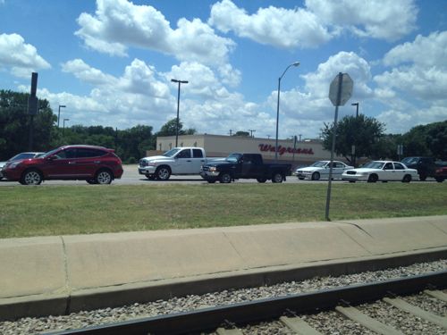
This is the traditional type of railroad track.

Track ballast forms the trackbed upon which railway sleepers (UK) or railroad ties (US) are laid. It is packed between, below, and around the ties. It is used to bear the load from the railroad ties, to facilitate drainage of water, and also to keep down vegetation that might interfere with the track structure. This also serves to hold the track in place as the trains roll by. It is typically made of crushed stone, although ballast has sometimes consisted of other, less suitable materials. The term “ballast” comes from a nautical term for the stones used to stabilize a ship. (Wikipedia)

Our light rail uses this type of track in its exclusive right-of-way, with wood ties in the original 1993 line and concrete ties in later extensions. Obviously, this is not used in places where cars drive in the same space. With railroads they are completely separate but when used in the public right-of-way (streets) it requires physical barriers to keep cars off the track.

Dallas' South Blue Line light rail uses ballasted track in a wide median
Dallas’ South Blue Line light rail uses ballasted track in a wide median

This is the least costly and fasted type of track. To achieve the highest speeds it’s important to have few conflict points (crossings) and greater distances between stops.

Embedded track

Embedded track is more costly to install than ballasted track, and vehicles operate at slower speeds.

Where a rail is laid in a Road surface (pavement) or within grassed surfaces, there has to be accommodation for the flange. This is provided by a slot called the flangeway. The rail is then known as grooved rail, groove rail, or girder rail. The flangeway has the railhead on one side and the guard on the other. The guard carries no weight, but may act as a checkrail.

Grooved rail was invented in 1852 by Alphonse Loubat, a French inventor who developed improvements in tram and rail equipment, and helped develop tram lines in New York City and Paris. The invention of grooved rail enabled tramways to be laid without causing a nuisance to other road users, except unsuspecting cyclists, who could get their wheels caught in the groove. The grooves may become filled with gravel and dirt (particularly if infrequently used or after a period of idleness) and need clearing from time to time, this being done by a “scrubber” tram. Failure to clear the grooves can lead to a bumpy ride for the passengers, damage to either wheel or rail and possibly derailing. (Wikipedia)

This type of track is more common where vehicles & pedestrians are in the same space as the track.

Embedded track, shared lane

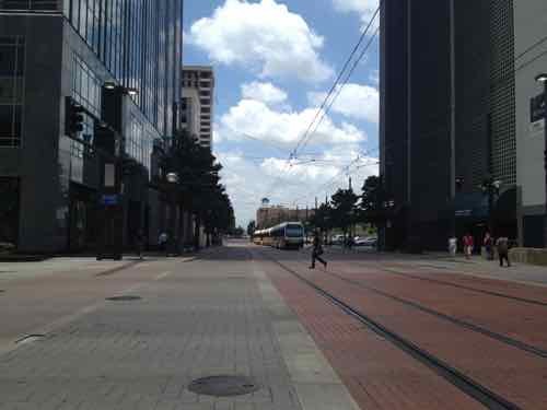
Dallas’ light rail doesn’t share lanes with vehicles, where it uses streets not in a median cars are banned.

Light rail in downtown Dallas uses embedded track on Pacific Street where cars are banned. Emergency vehicles like fire, ambulance, police can use this street. In some cities cars are allowed to share these lanes.

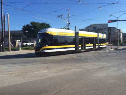
This is common for light rail. However, Dallas does have embedded track with shared lanes — their new tramway (aka streetcar).

Trams worldwide share lanes with other users.

Embedded track, separate lane

With a separate lane the transit vehicle can move slightly faster than it can when sharing a lane.

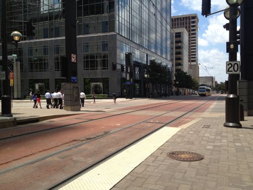
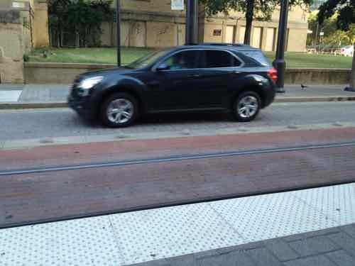
Dallas has a few spots where cars & transit use the same street. Transit here travels considerably slower than where it has an exclusive right-of-way.
Dallas has a few spots where cars & transit use the same street. Transit here travels considerably slower than where it has an exclusive right-of-way. Here cars can use the single grey lane, transit uses the red,
Here we see small bumps are used to let drivers know to stay in their lane (gray)

Each of these has their place, depending upon the situation and desired speed. I can see using ballasted track in auto-centric suburban medians, but not within the City of St. Louis or even inner-ring suburbs. The more separate ballasted track you have, combined with fewer stops, the faster the transit vehicle will get from A to B.

Those advocating more rail transit in St. Louis need to think about these track types and the implications of each.

— Steve Patterson


Reduced Fare Smart Card For Chicago, Still Waiting On St. Louis

Metro St. Louis is busy working on smart cards for paying transit fares, some have been testing the new technology. Meanwhile, we’ve been using the Ventra smart card for nearly 2 years when visiting Chicago. See Contactless Transit Smart Cards from February 2014. Last month I finally decided to apply for a reduced fare card.

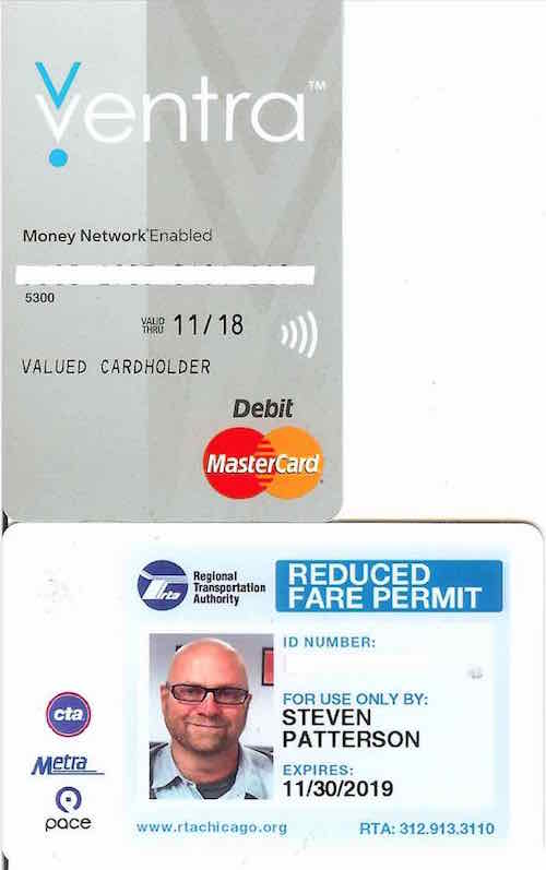
Full fare Ventra card (top) and my reduced fare card (bottom)

Both cards are now on one online account, allowing me to login to add value. My husband will use the full fare while I use the reduced fare with my picture. I applied in person in Chicago and the card was mailed to me in about a week. Both are “contactless” which means the user just taps it at the reader, both have a magnetic strip on the back. The same card works for all three Chicagoland systems: CTA, Metra, & Pace. It doesn’t appear my new reduced fare card can be used as a debit card — that won’t matter to me but it might to others.

In St. Louis, our Metro isn’t going to have a debit card connection — deemed too costly. I’m told existing reduced fare ID holders like myself will automatically receive a new reduced fare smart card — once ready. New applicants will apply in person but leave with the card rather than have it mailed. Since my current Metro reduced fare ID expires in February 2016 I’ll need to renew it once more before I get a smart card version.

— Steve Patterson


The St. Louis Region Should’ve Planned For Commuter Rail A Century Ago

In thinking about transit in other regions compared to ours, it is clear to me that natural geography and historic development patterns play a role in transportation planning in the 21st century. Decisions made a century ago, good & bad, still affect us today.

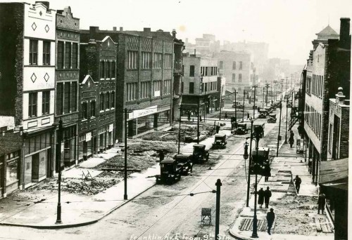
One hundred years ago St. Louis hired a 26 year-old civil engineer, Harland Bartholomew, to be its first planner. During the previous 151 years it developed organically, without planning, He quickly proposed widening many public rights-of-way (PROW) to make room for more cars.

Franklin Ave looking East from 9th, 1928. Collection of the Landmarks Association of St Louis

St. Louis city invested heavily in widening streets like Natural Bridge, Jefferson, Gravois.

More than three decades after arriving in St. Louis, Bartholomew got a Comprehensive Plan officially adopted (1947). His plan was all about remaking St. Louis because it would have a million residents by 1960 — or so he thought!

Here’s the intro to the Mass Transportation section:

St. Louis’ early mass transportation facilities consisted of street car lines operated by a considerable number of independent companies having separate franchises. Gradually these were consolidated into a single operating company shortly after the turn of the century. In 1923 an independent system of bus lines was established but later consolidated with the street car company. Despite receivership, re-organization and several changes of ownership the mass transportation facilities have been kept fairly well abreast of the city’s needs. Numerous street openings and widenings provided by the first City Plan have made possible numerous more direct routings and reduced travel time.

Approximately 88 per cent of the total area of the city and 99 per cent of the total population is now served directly by streetcar lines or bus lines, i.e., being not more than one quarter mile walking distance therefrom. Streetcar lines or bus lines operate directly from the central business district to all parts of the city’s area. There are also numerous cross-town streetcar lines or bus lines, operating both in an east-west and north-south direction. 

No mention of a regional need for commuter rail. Some might point out this was the city’s plan, not the region’s. That would be a valid point if it weren’t for the regional nature of the next section: Air Transportation:

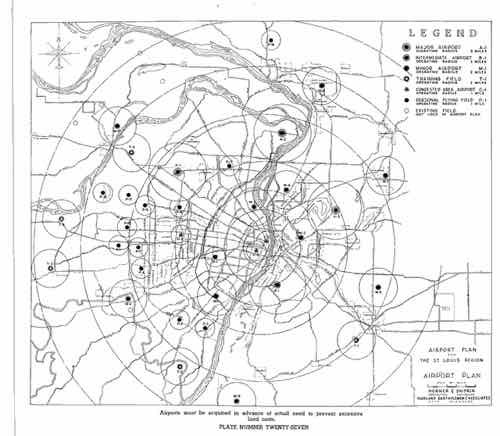
It is reasonable to assume that the developments in air transportation during the next few decades will parallel that of automobile transportation, which really started about three decades ago. St. Louis must be prepared to accept and make the most of conditions that will arise. Provision of the several types of airfields required must be on a metropolitan basis. The recently prepared Metropolitan Airport Plan proposes thirty-five airfields. See Plate Number 27. These are classified as follows:

  • Major Airports – for major transport 3
  • Secondary Airports – for feeder transport 1
  • Minor Fields – for non-scheduled traffic, commercial uses and for training 15
  • Local Personal Fields – for private planes 13
  • Congested Area Airports – for service to congested business centers 3
     
    [Total] 35

Of these, two major, eight minor, twelve personal and three congested area airports would be in Missouri. Lack of available land in the City of St. Louis limited the number within the corporate limits to two minor, one personal and two congested area airports. The selection of sites for the latter involves great cost and should await further technological developments in design and operation of various types of aircraft, including the small high powered airplane, the autogyro and the helicopter.

The three airports within the city are:

  • A Minor Field at the southern city limits east of Morganford Road.
  • A Minor Field in the northern section of the city between Broadway and the Mississippi River. (Since the publishing of the above report this field has been placed in operation by the city.)
  • A Local Personal Field in the western section of the city on Hampton Boulevard north of Columbia Avenue.

The latter is of special significance because of the great concentration of potential private plane owners in fairly close proximity. The northern minor field is adjacent to a large industrial area. The southern minor field would also serve a large industrial area as well as a considerable number of potential private plane owners.

So the region should have 35 airports but no commuter rail service? It should have numerous new highways but no commuter rail? Here’s the visual of the region with 35 airports:

Bartholomew's 1947 plan called for 35 airports un the St, Louis region!
Bartholomew’s 1947 plan called for 35 airports un the St, Louis region!

Thirty-five airports but no plan for mass transit beyond bus service?

Bartholomew left St. Louis in 1953 to chair the National Capital Planning Commission, where he created the 1956 plan for 450 miles of highway in the capital region.

During the 1960s, plans were laid for a massive freeway system in Washington. Harland Bartholomew, who chaired the National Capital Planning Commission, thought that a rail transit system would never be self-sufficient because of low density land uses and general transit ridership decline. But the plan met fierce opposition, and was altered to include a Capital Beltway system plus rail line radials. The Beltway received full funding; funding for the ambitious Inner Loop Freeway system was partially reallocated toward construction of the Metro system. (Wikipedia)

A book written by a partner of Bartholomew revises history to suggest he pushed for Washington’s Metro — see Chapter 10.

https://www.stlouis-mo.gov/archive/harland-bartholomew/HBaACh10.pdf

Washington has fewer miles of freeways within its borders than any other major city on the East Coast.” Thirty-eight of the planned 450 miles would have routed through D.C. proper; today, there are just 10. Instead, after a wrenching and protracted political battle, they write, “the Washington area got Metro—all $5 billion and 103 miles of it.” (Slate)

In 1945, as a paid consultant, Bartholomew said “the density of population of the Washington area would never be sufficient to warrant a regional rail system.” (Lovelace P141, chapter 10 p3). Most likely he felt that way about the St. Louis region. Though the city was quite dense during his decades here, the surrounding suburbs were low-density, still are.

But what if he had guided the region to develop boulevards to the North, West, & South of downtown with streetcars in the median? Today that right-of-way could be used for light rail. Cleveland, for example, is fortunate that Shaker Blvd & Van Aken Blvd  were planned as such, providing room for their Green Line & Blue Line, respectively.

Bartholomew was highly influential — the one person in the region that might have been able to lay the ground work for better mass transit in the 21st century. It wasn’t feasible like lots of highways & airports.

My point is when we think about future transportation infrastructure, and we look at other regions, we must keep in mind their planning & development decisions a century ago. Many still think we should’ve put light rail down the center of I-64 during the big rebuild — failing to realize there wasn’t a way to get a line into the center and it wouldn’t work well if we could since the housing along the route wasn’t developed around transit.

We were able to leverage rail tunnels under downtown and a rail corridor to get light rail to the airport. Other former rail corridors exist for new light rail lines, such as North along I-170 out of Clayton into North County. We do have excessively wide boulevards in the city & county, but cutting up the street pattern after the fact by putting light rail down the center and significantly reducing crossing points is similar to building a highway — it separates.

Moving forward with plans for new regional transportation infrastructure we must recognize we simply don’t have the advantages many other regions enjoy.  We can’t go back and undo decisions Bartholomew & others made a century ago.

— Steve Patterson


Advertisement


[custom-facebook-feed]

Archives

Categories

Advertisement


Subscribe