Home » Public Transit » Recent Articles:

Two Locally Preferred Bus Rapid Transit (BRT) Routes Selected

In September readers picked the I-64 BRT route between downtown and Chesterfield as their favorite of four bus rapid transit (BRT) routes being studied by the Transportation Corridor Improvement Group (TCIG), which “consists of staff from Metro, EWGCOG, the City of St. Louis, St. Louis County, and MoDOT”.

“None” was 2nd in the poll, but the next actual route favored was the West Florissant – Natural Bridge BRT option. On Tuesday the TCIG recommended two locally preferred alternative routes to Metro’s Operations Committee

After careful consideration and analysis of the transportation corridors, the TCIG recommended as the locally-preferred alternative two BRT projects: I-64 between Chesterfield and Downtown St. Louis, and a north-south route connecting North St. Louis County to Downtown St. Louis primarily via West Florissant Avenue and Natural Bridge Avenue.

See their report/presentation here.
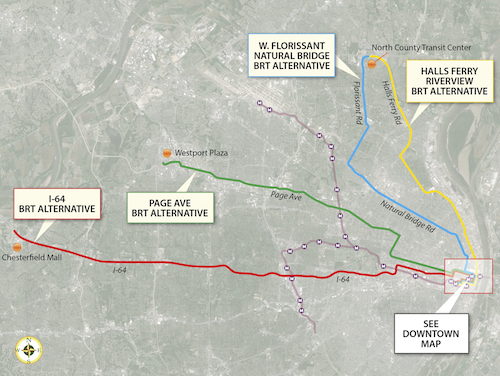
The four alternative BRT routes that were being studied.
The four alternative BRT routes that were being studied, click image to view larger version.

Let’s take a closer look at the two selected routes, from Tuesday’s report:

I-64 BRT (route)

The 1-64 BRT corridor spans 23 miles between the City of Chesterfield and Downtown St. Louis. It would serve a limited number of park-and-ride stations along I-64 between Chesterfield Mall and the Central West End. From the Central West End it would travel along Forest Park Avenue into Downtown St. Louis, making a loop through Downtown before ending at the Civic Center Station. As currently proposed, its service frequencies would match MetroLink, and transit prioritization strategies would be implemented along the corridor to speed transit travel.

The I-64 BRT would serve a Central Corridor that hosts 55,000 people and 115,500 jobs within one half-mile, outside of Downtown St. Louis. The addition of this high-performance service to the Metro System would provide the region’s first rail-like transit option in West St. Louis County, offering the first opportunity for all-day, single-seat service between Chesterfield and Downtown St. Louis, and reducing transfers from other areas by half. Along with reducing transfers, it would improve transit travel time within the corridor by 30%, making it a much more attractive alternative to the personal automobile. Ridership projections from EWGCOG’s regional travel demand model show a potential ridership market of 5,100 weekday riders, 2,100 (41%) of whom would be new “choice” riders. That market is projected to grow to 6,800 weekday riders by 2040.

I-64 BRT CONSUMER BENEFIT

  • End-to-end transit travel time reduced from 76 minutes to 53 minutes
  • – Compared to auto travel time of 25 minutes
  • – Offers motorists option of comfortable, affordable, productive commute
  • Corridor ridership projected to increase 357% from 1,115 to 5,100 weekday riders opening year; 6,800 in 2040
  • – 2,100 (41%) new “choice” riders opening year
  • Enhanced service
  • – BRT option provides single-seat service not currently available
  • – Reduce transfers by 50%
  • – End-to-end service available all day, rather than only peak
  • – Create additional hubs to make local bus service more efficient

This route makes a lot of sense to me. It gets a higher level of transit service on this corridor without the enormous infrastructure expense that would be required for light rail. It would run down Forest Park Ave & Boyle, running right past the proposed IKEA and connecting with the proposed new CORTEX MetroLink station. Transit time would be reduced from three times driving to twice driving. For some that’s still a non-starter, but for others it would allow them to avoid  driving/parking headaches while being able to be productive. It doesn’t need to get every driver out of their cars to be a success.

West Florissant – Natural Bridge BRT (route)

The other transit project included in the LPA is an arterial-based BRT route connecting North St. Louis County to Downtown St. Louis. This service would operate out of the new North County Transit Center, running 16 miles to Downtown via West Florissant Avenue, Lucas and Hunt Road, and Natural Bridge Avenue. As currently proposed, its service frequencies would match MetroLink; stations with a high level of customer amenities would be spaced a minimum of one mile apart; and transit prioritization strategies would be implemented to speed travel.

The combined West Florissant-Natural Bridge corridor hosts 70,000 people and 18,000 jobs within a half-mile, not counting Downtown St. Louis. Supplementing the local bus network in this strong and proven transit market will give residents of North St. Louis City and near-North County their first high-performance, rail-like transit option. It will reduce transit travel time and any required transfers by half. It would also greatly improve access and travel time between some of the region’s most disadvantaged areas and major jobs centers in Downtown and the Central Corridor, particularly if paired with the I-64 BRT option. Ridership projections from EWGCOG’s travel demand model show a potential ridership market of 3,200 weekday riders, 600 (19%) of whom would be new “choice” riders.

W. FLORISSANT–NATURAL BRIDGE BRT CONSUMER BENEFIT

  • End-to-end transit travel time reduced from 85 minutes to 42 minutes
  • – Compared to auto travel time of 25 minutes
  • – Attractive amenity package offers affordable, comfortable commute
  • Corridor ridership projected to increase 23% from 2,610 to 3,200 opening year and 2040 (Natural Bridge)
  • 600 (19%) new “choice” riders
  • Enhanced service
  • BRT option supports fast single-seat ride to Downtown St. Louis
  • If paired with I-64 BRT, travel from North County to CWE and West County would require only 1 transfer between 2 high-speed routes; currently requires multiple transfers and 2-3 local routes

Unlike going to Chesterfield, reaching downtown from North St. Louis County isn’t very direct via car or transit. This will help reduce travel time for existing transit users and is expected to attract new riders. The streetscape improvements along the route will benefit everyone in the area.

Additional information

Travel speeds competitive with MetroLink

  • Avg MO MetroBus speed = 16.02 mph
  • Avg MO MetroLink speed = 25.63 mph
  • I-64 BRT speed = 26.04 mph
  • WFNB BRT speed = 25.71 mph

The report has very detailed cost projections, here’s the summary:

  • I-64 BRT: $37.9M capital; $4M net operating
  • West Florissant – Natural Bridge BRT: $39.1M capital; $2.6M net operating

Additional operational revenue would be necessary for this additional service.

Next Steps

Metro’s board is expected to vote to approve these two locally preferred routes at their March 28th meeting.  If approved it goes to East-West Gateway Council of Governments, the Metropolitan Planning Organization (MPO) for the St. Louis region. Once part of our 2040 transportation plan we can seek capital funding through the Federal Transit Administration’s Small Starts program.

Again, much more detail is with the report/presentation from Tuesday.

— Steve Patterson
 

Wrap on New Downtown Trolley Buses a Great Improvement

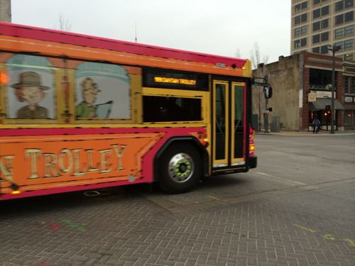
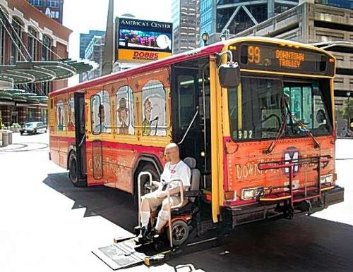
The #99 Downtown Trolley, regular buses with a cartoon wrap, have been on the streets since July 2010. People laugh at the wrap but it’s effective.

The original Downtown Trolley used a short bus with steps & wheelchair lift.  Photo by Jim Merkel, Suburban Journals
The original Downtown Trolley used a short bus with steps & wheelchair lift. This is me exiting the trolley at the July 2010 debut. Photo by Jim Merkel, Suburban Journals

The one problem with the original is the wrap made it impossible to see out the side windows. Tourists & locals unable to see the city….no good. Recently the original trolley buses were replaced by new Gillig low-floor buses.

The wrap on the new buses looks like the original
The wrap on the new buses looks very similar the original, with one major difference…
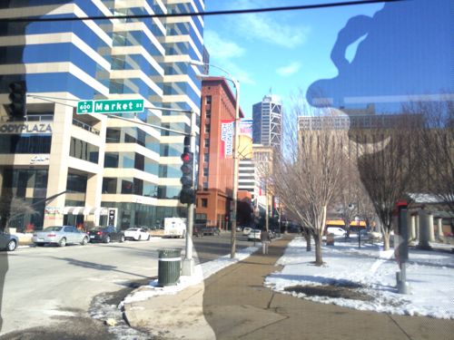
The new wrap allows passengers inside to see out
The new wrap allows passengers inside to see out, this is looking north on 7th from Market

I love the new Gillig low-floor buses, so much quicker & easier to board/unboard, but the ability to see out is a huge improvement, a very pleasant surprise!  The wrap is licensed from a company that holds the rights to use a trolley likeness.

— Steve Patterson


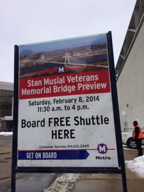
Accessing the Opening of the Stan Musial Veterans Memorial Bridge

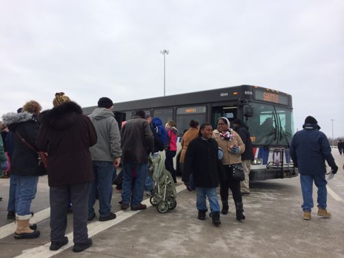
Despite the cold weather thousands came out Saturday to see the new Stan Musial Veterans Memorial Bridge a day before it opened to vehicle traffic. The shuttle we rode from 9th near Washington onto the bridge was packed tighter than the #70 Grand bus during peak use.   I overheard some saying how nice the bus seamed, likely their first time on a bus.  Our shuttle passed by the last two stops because we couldn’t take on another passenger.

MetroBus shuttles were very popular
A shuttle stop on 9th St
A shuttle stop on 9th St., if only bus stops were this visible…

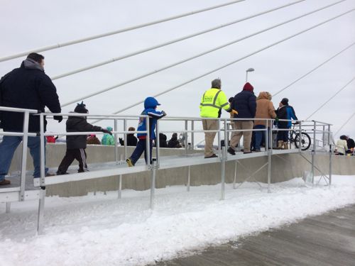
As we approached I wondered if there would be a break in the center dividing wall to get from the westbound lanes to eastbound lanes. There wasn’t, instead the had ramps to cross over.

Temporary ramps made it possible for everyone to cross over the center dividing wall.

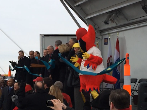
I don’t have any stunning bridge photos, it was too cold & gray to attempt. We did stay through all the speeches at the ribbon cutting.

Seconds after Illinois Gov Quinn & Missouri Gov Nixon cut the ribbon

I look forward to driving across the bridge, and seeing it night. This is an interesting example of a very cost-effective structure type also being very beautiful, sometimes limited budgets can result in a better finished product than unlimited budgets.

Hopefully any new development at each approach will be worthy.

— Steve Patterson


CORTEX TOD Study From October 2012 Now Online

Last month I wrote Cortex District Needs A Pedestrian Circulation Plan Before IKEA Is Built knowing a master plan was in the works, or had already been approved.  Still, I couldn’t find a copy online. I began emailing CORTEX directly, and then others, until January 10th when I got the response I was looking for:

Good morning, Steve:

John Hoal forwarded me your query about the Cortex Station Area Plan report. I spoke with SLDC, who confirmed that the report was not, in fact, posted on-line. The report has since been posted to SLDC’s website, and the link to the report materials is included below.

http://www.stlouis-mo.gov/government/departments/sldc/documents/CORTEX-Transit-Oriented-Development-Study.cfm

Thanks, Steve. Please let us know if you have any additional questions or require further information.

Best regards,

Timothy Breihan

H3 Studio

Turns out the report was finalized in October 2012! Fifteen months later, after my inquiries, it was made available online.  This work was funded by tax payers and should’ve been made available when finalized:

The work that provided the basis of this publication was supported by funding under an award with the U.S. Department of Housing and Urban Development through East-West Gateway Council of Governments. The substance and findings of the work are dedicated to the public. The author and publisher are solely responsible for the accuracy of the statements and interpretations contained in this publication. Such interpretations do not necessarily reflect the views of the Government or the East-West Gateway Council of Governments. (Page 2)

Ok, it’s online now so let’s take a look:

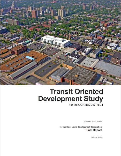
Cover of the TOD study for CORTEX. Click cover to view on Scribd.

From the objective at the start:

Originally developed as a light-industrial enclave, the CORTEX district faces major challenges moving forward to make itself feel welcoming, pedestrian-friendly, and fundamentally connected to its surrounding neighborhoods and amenities. (Page 6)

[snip]

The Transit Oriented Development Study (TOD) for the CORTEX District (the Study) seeks to establish projections for net new riders on the MetroLink light rail system over a 20-year planning horizon resulting from the construction of a new MetroLink station in the CORTEX District. This Study is focused on proposed ridership projections based on planned investments in CORTEX and the surrounding areas. Metro Saint Louis Transit and the Bi-State Development Agency (Metro), owners and operators of the MetroLink and MetroBus transit systems, have established target thresholds as goals for proposed stations.

This station will be an invaluable asset in the future development potential of both the CORTEX district and the region-wide MetroLink system. The proposed station has the potential to function both as a transit option for current and future area residents and employees, as well as a major amenity and connective element for the surrounding neighborhoods and residents. In order to capitalize on years of public and private investment and attract and retain the best and the brightest, it is imperative that development in the CORTEX district unlocks the latent potential present in the district’s enviable location in the heart of Saint Louis. The City of Saint Louis, Metro, and CORTEX possess a significant opportunity to recreate the district as a key link between surrounding neighborhoods, with the ability to tie these neighborhoods together with public spaces, great pedestrian streets, mixed-use development, and multi-modal transit access. (Page 6-7)

The first “consensus issue” surrounding CORTEX is listed as:

1. Forest Park Avenue is perceived as unfriendly to bikes and pedestrians for east-west travel and crossing. (Page 11)

Really? The planning process gets into trouble when too much weight is given to public input. Forest Park Avenue has what they want to create one block south on Duncan Ave.; on-street parking which separates traffic from pedestrians, tree lawns with mature trees, etc. But a few neighbors that probably don’t walk indicated they don’t like Forest Park Ave., possibly because they were steered that way, so it’s dismissed as an east-west pedestrian route.  The crossings do need to be improved to get people into the CORTEX District and to/from the proposed MetroLink station.

Under “scenerio 1” to increase transit ridership they list:

Focus TOD residential and mixed-use development between Sarah Avenue and Vandeventer Avenue and extend planned Duncan Avenue streetscape improvements east to Vandeventer. (Page 14)

But the proposed IKEA will prevent the new pedestrian-friendly Duncan Ave from reaching Vandeventer Ave, occupying most of the residential/mixed-use development area. Will this plan be amended to deal with that new reality? This is why major streets (Forest Park Ave.) shouldn’t be ignored in favor of expendable streets (Duncan Ave). Are ridership projections still valid with a large mixed-use area on the east side of the proposed station?

Let’s continue:

4. ENSURE PEDESTRIAN AND BIKE CONNECTIVITY, SAFETY, AND COMFORT

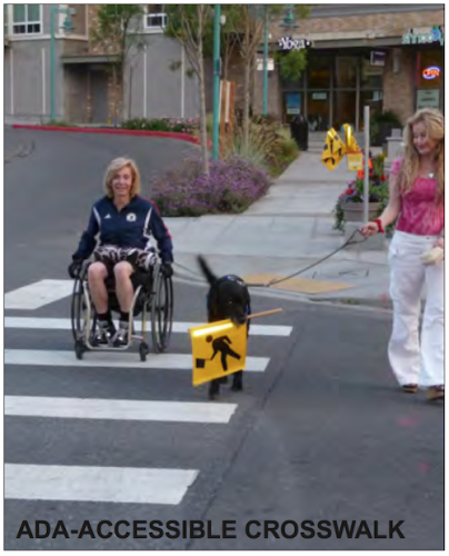
The photo on Page 119 labeled as "ADA-Accesible Crosswalk" shows a non-ADA compliant ramp.
The photo on Page 119 labeled as “ADA-Accesible Crosswalk” shows a non-ADA compliant ramp. No diagrams are included on how to make ramps & crosswalks ADA-compliant.

Transit-oriented developments and districts rely on safe, comfortable, walk-able and bike-able streets and public spaces to provide access to transit. In the CORTEX district, streets are currently designed to give preference to vehicular traffic; most streets have only a 36-foot curb-to-curb width, which accommodates only two travel lanes and two parallel parking lanes. In addition, sidewalks are only 4- to 5-feet wide, pedestrian right-of-ways are often obstructed by utility poles and other infrastructure, and there are few street trees or other pedestrian amenities. Given limited right-of-way width and vehicular traffic restrictions, enhancing bike and pedestrian connectivity, safety, and comfort will need to occur on some streets while vehicular service requirements are accommodated on others. Actions to achieve this strategy include:

  • Create “pedestrian first” streets and vehicular-centric streets through the district.
  • Repair all sidewalks and maximize sidewalk width in all locations.
  • Provide planting strips and/or tree lawns on all streets.
  • Relocate utility poles and other infrastructure out of pedestrian right-of-ways.
  • Provide lane-width, shared lane markings (“Super Sharrows”) on all streets.
  • Provide parallel parking on all streets.
  • Provide street trees on all streets with a maximum spacing of 40-feet on-center.
  • Provide pedestrian-scaled street lights with a maximum spacing of 80-feet on center.
  • Provide trash receptacles, benches, bike racks, safety call boxes, and other street furniture.
  • Provide ADA-accessible curb cuts, oriented perpendicular to the street, at all intersections and crosswalks.
  • Provide pavement changes at all crosswalks. (Page 22)

Well “pedestrian first” is mentioned earlier (p13) and later on pages 69 & 119, yet nowhere does the report define “pedestrian first”.  To be fair, “vehicular-centric streets” isn’t defined either,  but I think St. Louis has that one down.

The big pedestrian push is Duncan Ave., which will terminate unceremoniously into the side of the IKEA:

A potential major east-west corridor within the CORTEX District is Duncan Avenue, which runs from Sarah Street and Vandeventer Avenue to the east and the Central West End MetroLink Station and Barnes Jewish/Washington University Medical Campuses to the west. Where Duncan Avenue intersects with Boyle Avenue is the heart of the CORTEX District with the CORTEX building to the north and the Solae building to the south. (Page 78)

It does include a list of existing conditions.

ASSESSMENT OF EXISTING SIDEWALK AND STREET PAVEMENT CONDITIONS

BOYLE AVENUE CORRIDOR

  • Overall, the street pavement is in poor to fair condition with alligator cracking, sections where base pavement is exposed, and numerous patches of pavement.
  • Curb material varies with either granite or concrete curb. Concrete curb is usually in sections where sidewalk has been replaced.
  • The standard curb height of six inches occurs mainly in sections where sidewalk has been replaced. Remaining sections of curb are less than six inches due to overlaying of street pavement.
  • The sidewalks are mainly in poor to fair condition with broken and uneven pavement. Numerous patches occur in the sidewalk pavement due to underground utility improvements. In areas where new construction or street improvements have occurred at street intersections, the sidewalks are in good condition.

TOWER GROVE AVENUE CORRIDOR

  • Some sections of Tower Grove Avenue have been newly overlaid with asphalt leaving them in good condition. Most other areas of the street pavement have alligator cracking, sections where base pavement is exposed and numerous patches of pavement and should be considered in fair to poor condition.
  • Overall the sidewalks are in poor to fair condition with prevalent pavement cracking and uneven areas. Some sections of sidewalk have been replaced at intersections with road improvements. Where new building has occurred, new sidewalk has been installed.
  • Curbing in this section of Tower Grove Avenue is mainly granite curb with concrete curb occurring at street intersections. Overlaying of the street pavement has reduced the height of the curb to less than six inches.

NEWSTEAD AVENUE CORRIDOR: FOREST PARK PARKWAY TO CLAYTON AVENUE

  • The street pavement is in fair to poor condition with numerous patches, large amounts of alligator cracking, and sections of exposed base pavement.
  • The sidewalks are in fair to good condition. Decorative medallions have been added to the sidewalk. A short section north of the MetroLink tracks has uneven and cracked pavement, and the east sidewalk from Forest Park Parkway to Duncan Avenue has some remnants of a sidewalk in places.
  • Curbing material overall is composed of granite, but some areas closer to Forest Park Parkway are concrete.

DUNCAN AVENUE CORRIDOR: NEWSTEAD AVENUE TO SARAH STREET

  • The street pavement is in poor condition with numerous patches, large amounts of alligator cracking, and sections of exposed base pavement from raveling top mat of asphalt and potholes.
  • The sidewalks are in fair to poor condition. There are several sections of sidewalk which have been replaced, and those are located on the north and south sides of Duncan Avenue at the CORTEX and Solae Buildings and parking lots as well as the West End Lofts parking lot near the intersection of Sarah Street and Duncan Avenue.
  • Curbing material mainly is composed of granite except in the sections of the CORTEX and Solae buildings. (Page 82-83)

No mention of the problem at Duncan & Newstead.

HIERARCHY OF STREET USAGE BY PEDESTRIANS AND BIKES

From Stakeholder meetings with neighborhood committees and residents, City agencies and other concerned parties a hierarchy of primary pedestrian and bike routes were determined to help aid in the development of a Street-Level Connectivity Plan.

East-West Pedestrian Corridor: Laclede Avenue and Chouteau Avenue (Most Preferred) Forest Park Parkway (Least Preferred)

North-South Pedestrian Corridor: Newstead Avenue and Euclid Avenue (Most Preferred) Boyle Avenue and Taylor Avenue (Least Preferred)

East-West Bike Corridor: Chouteau Avenue (Most Preferred) Duncan Avenue (Least Preferred)

North-South Bike Routes: Newstead Avenue (Most Preferred) Vandeventer Avenue (Least Preferred (Page 85))

Hopefully you’ll be able to find detail I missed.  To me this is a plan filled with buzz words that’s already being ignored a year later, business as usual. I’ll repeat: CORTEX needs a pedestrian plan because this isn’t close.

— Steve Patterson


New MetroBus Shelter To Be Built On 14th @ Washington Ave

It’s not everyday a new bus shelter is built, they’re expensive and permanent.

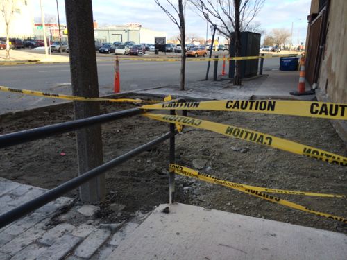
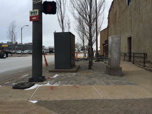
14th St @ Washington Ave.: Stones pavers & concrete removed so a new bus shelter can be built.
The public right-of-way on 14th at Washington Ave

This stop serves the northbound 32 (ML King-Chouteau), 41 (Lee), and 74 (Florissant) MetroBus routes.  In the last 5 years it has been located a block north and in each of the two blocks to the south, moving every so often. This location offers the most space, but the decorative rough stone pavers have been a trip hazard.

Unfortunately the adjacent business wasn’t informed of the construction in advance. I think anyone working in the public right-of-way should attempt to give some advance notice to those impacted by construction. Metro St. Louis contracts with Wall for bus shelters.

— Steve Patterson


Advertisement


[custom-facebook-feed]

Archives

Categories

Advertisement


Subscribe