Celebrating Blog’s 19th Anniversary


  Nineteen year ago I started this blog as a distraction from my father’s heart attack and slow recovery. It was late 2004 and social media & video streaming apps didn’t exist yet — or at least not widely available to the general public. Blogs were the newest means of …

Thoughts on NGA West’s Upcoming $10 Million Dollar Landscaping Project


  The new NGA West campus , Jefferson & Cass, has been under construction for a few years now. Next NGA West is a large-scale construction project that will build a new facility for the National Geospatial-Intelligence Agency in St. Louis, Missouri.This $1.7B project is managed by the U.S. Army …

Four Recent Books From Island Press


  Book publisher Island Press always impresses me with thoughtful new books written by people working to solve current problems — the subjects are important ones for urbanists and policy makers to be familiar and actively discussing. These four books are presented in the order I received them. ‘Justice and …

New Siteman Cancer Center, Update on my Cancer


  This post is about two indirectly related topics: the new Siteman Cancer Center building under construction on the Washington University School of Medicine/BJC campus and an update on my stage 4 kidney cancer. Let’s deal with the latter first. You may have noticed I’ve not posted in three months, …

Recent Articles:

Metro Makes Long-Needed Changes at 18th & Clark, Still Violates ADA


In a couple of weeks Metro’s new North County Transit Center will open, so many MetroBus routes will see major changes:

Metro’s quarterly service change on March 14 will impact the operations of 48 MetroBus routes in the St. Louis metropolitan region, including the introduction of nine new MetroBus routes and discontinuation of service on eight routes. This service change will also introduce a new and completely redesigned MetroBus service plan for North St. Louis County, made possible with the opening of the new North County Transit Center in Ferguson, Missouri on March 14. (Metro)

On that same day, changes will take place in downtown (technically Downtown West):

The Civic Center Transit Center is scheduled to be closed down for construction activity shortly, at a date to be decided. In advance of the closure, Metro has prepared bus stops at 18th Street & Clark Street, adjacent to the Union Station MetroLink, to provide the same system connectivity. 

The routing and schedules of the routes serving the Civic Center Transit Center have been modified to serve 18th Street & Clark Street to ensure the same connections with the other MetroBus routes and MetroLink at Union Station instead.

Please note that till the closure of the Civic Center Transit Center, these routes will continue to serve the Civic Center Transit Center. Public Announcement of the closure of the Civic Center Transit Center will be made in advance of the event. (Metro)

The following MetroBus routes will change to include 18th & Clark.

  • 10 Chippewa
  • 32 ML King-Chouteau
  • 41 Lee
  • 73 Carondelet
  • 80 Park-Shaw
  • 94 Page
  • 97 Delmar
  • 99 Downtown Trolley
  • 40X I-55 Express
  • 58X Twin Oaks Express
  • 410X Eureka Express

When I need to catch the #10 Westbound I do so at 16th & Olive, but starting March 14th it’ll use 18th rather than 14th Street. Same goes for the #97  — I usually catch it at 16th & Washington but it’ll turn on 18th.  Those who ride the #94 & #97 to Washington & 14th, then catch the #99 Downtown Trolley to take them the rest of the way into the Central Business District (CBD), will need to figure out an alternates. Perhaps catching the Trolley bus at Civic Center/18th & Clark? That’ll require more time though — years ago more bus routes entered the CBD.

For a few months now I’ve been watching the changes at 18th & Clark. I posted about the upcoming Civic Center changes in 2014, see Civic Center Transit Center Sans Trees, Awaiting Redo.

Before I get into the recent changes along Clark I want to show you the before conditions, in October 2011 & August 2012.
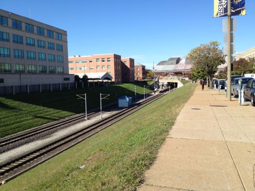
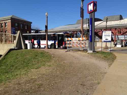
Looking west toward the Union Station MetroLink Station from 16th & Clark, October 2011.

At 18th pedestrians had worn a more direct path since MetroLink opened in 1993, October 2011

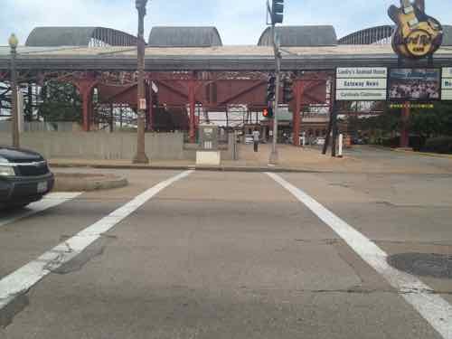
The crosswalk to Union Station led directly to a curb, those of us in wheelchairs had to go outside the crosswalk and use the auto exit, at right -- a clear ADA violation for years, August 2012
The crosswalk to Union Station led directly to a curb, those of us in wheelchairs had to go outside the crosswalk and use the auto exit, at right — a clear ADA violation for years, August 2012

Ok, so now you’ve seen the before. In December last year I began seeing work going on so I braved the cold one day to get some pics:
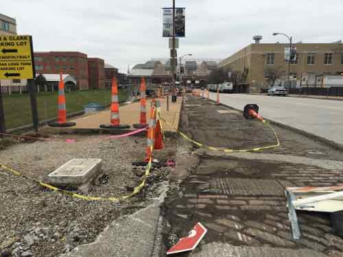
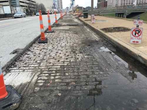
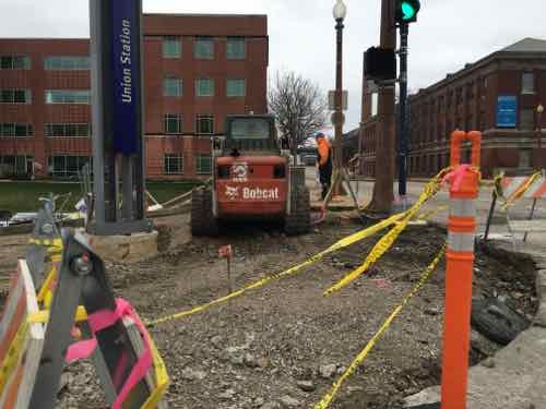
The asphalt in the parking lane was removed, sidewalk & curb ramp at 16th also removed, December 2015

The old bricks were visible, street trees gone, December 2015

The corner was completely opened up, forms were placed for new concrete, December 2015

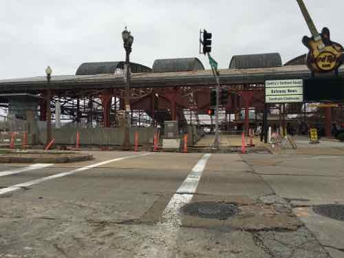
Looking West across 18th you can see the curb & sidewalk have been removed, December 2015

From the West side of 18th looking back, December 2015

I was encouraged seeing the West end of the crosswalk completely removed — a fresh start so it’ll be done correctly! I returned a month later, in late January:
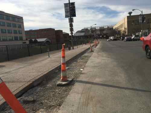
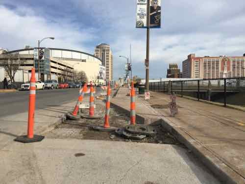
Now we can see the sidewalk has been widened, replacing half the parking lane, January 2016

About halfway between 16th -18th the extra sidewalk narrows to the original width, January 2016

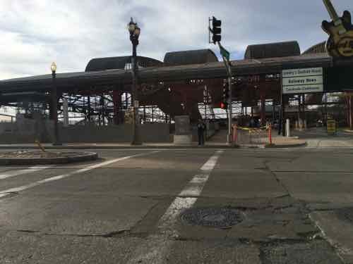
Looking across 18th we see at the end of the crosswalk --- A NEW CURB! WTF!?!
Looking across 18th we see at the end of the crosswalk — A NEW CURB! WTF!?! January 2016

Pedestrians taking the direct route from MetroLkink East across 18th, with the ramp on the left, January 2016

I returned again, a month later, on February 26th:
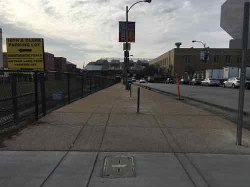
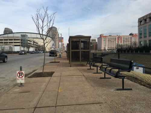
The widest park, near 16th
The widest park, near 16th, February 2016

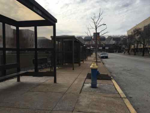
Temporary bus shelters added in the narrow section makes it tight, February 2016

There are new benches in places , February 2016

Crosswalk not yet changed to include the new curb ramp, February 2016

The ramp location behind the crosswalk is a head scratcher, for sure. I resisted the urge to post it to social media — opting to wait until the project is closer to completion.  I even went back yesterday to see if the crosswalk had been changed. It hasn’t. I also discovered another problem: pedestrian signal location.
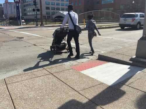
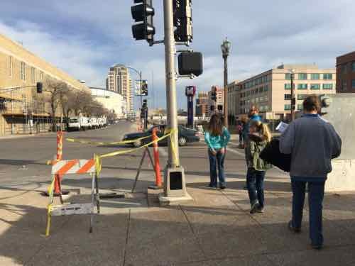
I arrived on the West side just as people pushing a stroller used the ramp to cross 18th

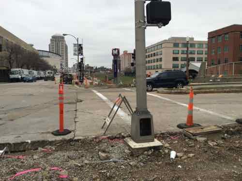
That's when I noticed the pedestrian signs, far right, wasn't visible. The ramps also aren't aligned, but we already knew they wouldn't.
That’s when I noticed the pedestrian signs, far right, wasn’t visible. The ramps also aren’t aligned, but we already knew they wouldn’t.

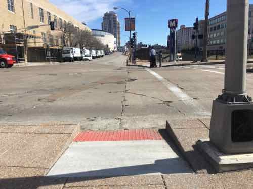
The pedestrian signal is visible only when way South pf the ramp & crosswalk

From the same spot you can see the ramp. My chair is very fast so I was able to wait for the walk signal then move to the ramp & cross -- but not everyone can move so quickly
From the same spot you can see the ramp. My chair is very fast so I was able to wait for the walk signal then move to the ramp & cross — but not everyone can move so quickly

From the East side you can see the back of the pedestrian signal and how it doesn't relate to the other side
From the East side you can see the back of the pedestrian signal and how it doesn’t relate to the other side

The best words that come to mind are gross incompetence. Both sides were completely opened up — all new concrete. That was the time to move pedestrian signals so they align with the crosswalk, to build the new ramps so they also align. I’m not sure if St. Louis’ new bike-pedestrian coordinator reviewed this, but other civil engineers did see it on paper. This is yet another thing making me realize I need to live in another city.

— Steve Patterson
Another Local Example of In-Street Light Rail


A couple of weeks ago I posted about a local example of light rail in center of a street, which was largely misunderstood. Objections to my Meramec Ave & Forest Park Parkway example included:

  • Cars could never cross here
  • Pedestrians have no reason to cross here
  • Several cities have light rail systems without concrete walls, have pedestrian crossings

True, true, and true. No argument. My point was many existing cross streets would no longer be able to cross streets like Natural Bridge or Jefferson if we built light rail in the right-of-way. Places to cross by car, bike, or foot would be limited.

Some of the examples people mentioned included Minneapolis and Houston. I have no personal experience with either so I turned to the internet.

Houston’s original Red Line, opened in 2004, had few obstacles. The tracks were in the street with very little dividing it from traffic (example).  Similar for their 2013 Red Line extension (example). The Green & Purple lines, opened in May 2015, are different. The Purple line has fences & barriers (example) but does provide pedestrian crossings between stations (example). Houston usually has 3-6 accidents per month, but had 17 in July.

Besides accidents, these can be slow. From 2014:

Residents of the Twin Cities greeted the opening of the new Green Line light rail link last month with joy and excitement, finally able to take advantage of a train connection between downtown Minneapolis and St. Paul. The 11-mile rail line runs through a relatively densely populated area, serves two business districts, and travels through the heart of a university.

It’s also alarmingly slow. Green Line trains are taking up to an hour to complete their journeys, and even optimistic schedules released by the local transit agency put running times at 48 minutes, or less than 14 mph on average.

Of course, the Twin Cities are hardly alone in their predicament. Recent transit lines elsewhere in the country feature similarly leisurely travel times. The new Houston North Line, for example, is averaging 17 mph. Los Angeles’ Expo Line is slightly quicker at 18 mph. Bus rapid transit and streetcar projects popping up virtually everywhere are often significantly slower. Only the Washington, D.C. Metro Silver Line, which will extend that region’s subway deep into the Virginia suburbs, will speed commuters along at an average of 32 mph. It will do so while only stopping at 5 stations, all of which will be located in the middle of expressways.

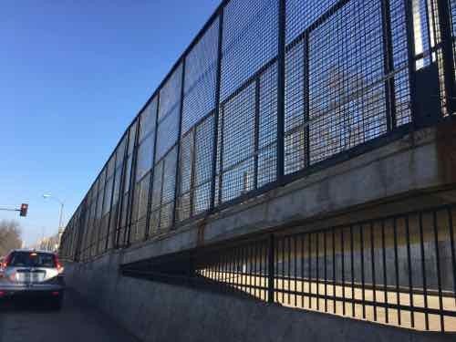
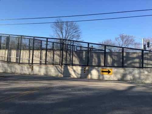
Our MetroLink, which operates in exclusive right-of-way, has an average speed of 24,7mph, according to Wikipedia. How does Metro achieve higher speeds? Less conflict points mean the vehicles can get to higher speeds between stations.  Which brings me to another local example of how Metro builds light rail to reduce conflicts/accidents. Forest Park Parkway & Des Peres Ave., prior to the Blue Line, was as signalized intersection allowing cars, bikes, and pedestrians to cross the busy roadway.

The intersection is still signalized  — and cars coming from the North can still cross here, as can pedestrians & cyclists. It’s roughly halfway between the Skinker & Forest Park stations — a mile apart.

Northbound traffic on Des Peres Ave can't cross the high-speed tracks
Northbound traffic on Des Peres Ave can’t cross the high-speed tracks

Cyclists & pedestrians must use ramps to cross over the tracks.

Anyone who thinks Metro St. Louis will build an in-street light rail system — operated at expected light rail speeds — with easy pedestrian crossings between stations is naive. It’s not going to happen — and it shouldn’t. St. Louis has enough pedestrian deaths as it is!

I think we should improve North-South public transit in the region, through the city.   I’m just looking at how Metro builds light rail and thinking it isn’t what people want.

— Steve Patterson


Sunday Poll: Likelihood of a Cyber Attack on the U.S. Power Grid?

February 28, 2016 Featured, Sunday Poll 5 Comments
 

Please vote below
Please vote below

Former ABC News anchor has a new book out warning readers about the threat of a cyber attack on our power grid:

We are accustomed to cyber-attacks that result in grand larceny. We are accustomed to cyber-attacks that amount to huge vacuuming of intelligence information. 

What we have never had is a cyber-attack that amounts to a weapon of mass destruction. And my point is that, if someone succeeds in taking down one of our power grids — and the Russians and the Chinese can do it and maybe the Iranians and the North Koreans — it would be devastating. (Ted Koppel via PBS News Hour)

This seemed like a good topic for a poll.

The poll will close at 8pm tonight, I’ll discuss my thoughts and the results on Wednesday.

— Steve Patterson

Long-Vacant Jefferson Arms May Finally Be Occupied Again


News broke Wednesday of a developer having the Jefferson Arms, originally known as The Hotel Jefferson, under contract:

Mike Sarimsakci, founder and president of real estate developer Alterra International, has the building under contract for an undisclosed price.

His plans for the Jefferson Arms were unclear but could be similar to Alterra’s hotel-and-apartment redevelopment of an old Butler Brothers warehouse in Dallas, officials said.

Real estate investor David Jump, who owns the building, was unavailable for comment. (Jefferson Arms renovation possible — Post-Dispatch)

While this is exciting news, it isn’t the first time in the last decade the building was to be renovated.

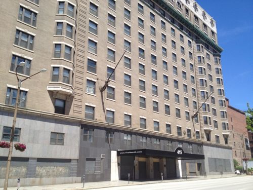
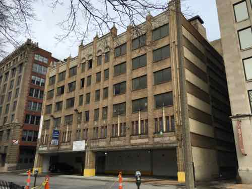
East facade facing Tucker (12th), June 2013

Pyramid Construction, before going under in 2008, had bought the building  — in 2007 Pyramid kicked out the existing residents (seniors) to prepare for renovation. This quote picks up the story:

After it was foreclosed on in 2009, the Jefferson Arms has been at the center of a four-year-long legal dispute involving [Barry] Cohen and the Federal National Mortgage Association.

In March 2011, a partnership led by Cohen filed a federal lawsuit in St. Louis against EF&A Funding, alleging an agent at EF&A gave Cohen misleading information when he refinanced a loan on the Jefferson Arms.

Cohen’s partnership, Affordable Communities of Missouri, also sued Federal National Mortgage Association, better known as mortgage giant Fannie Mae, seeking to recoup a $500,000 loan penalty paid after Cohen sold the Jefferson Arms building to Steffen’s company. EF&A later settled with the partnership, but Fannie Mae remained as a defendant. February 2015: Jefferson Arms shows complexities of downtown dealmaking — Post-Dispatch

In 2012/13 it looked again like something might happen:

Not so fast on writing off the plan by McGowan Brothers Development to rehab the empty Jefferson Arms in downtown St. Louis.

Owner David Jump has the building up for sale, but developer Tim McGowan said Friday that his company was still seeking federal New Markets Tax Credits to help finance the apartment redevelopment of the huge building at 415 North Tucker Boulevard.

McGowan said he hoped to find out in the first week of April if the Jefferson Arms project gets the federal tax credit this year. The project got shut out in last year’s allocation. (February 2013: McGowan Brothers still pursuing Jefferson Arms project — Post-Dispatch)

Hopefully this time the building will be renovated and reoccupied — I’m cautiously optimistic.

Like other large downtown buildings, such as the Arcade/Wright, the Jefferson Arms was built in phases — adding to the complexity of renovating for use in the 21st century. To understand the building one of the best sources is the 2003 nomination to the National Register of Historic Places. The following are selected quotes:

Page 29:

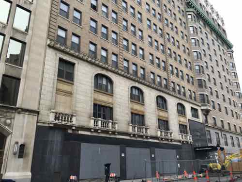
The Hotel Jefferson, located at 415 North Tucker Boulevard in downtown St. Louis, is a thirteen-story steel frame hotel building and six-story reinforced concrete parking garage, all clad in Revival style veneers of brick and terra cotta. The east half of the hotel was built in 1904 and fronts 220 feet along the west side of Tucker Boulevard (once Twelfth Street) and 100 feet along St. Charles Street to the north, and Locust Street to the south. In 1928, the building expanded to the west another 100 feet. Also erected in 1928, the Jefferson Plaza Garage (measuring 145 feet by 110 feet) at the southeast corner of St. Charles and North Thirteenth Streets, joins the west elevation of the 1928 addition. The storefront level of both the original hotel building and the addition was altered circa 1953 when portions of the terra cotta veneer were replaced with grey and black granite. Metal panels were also installed to wrap around the columns and border the new entrance, which was moved back to its 1904 location at the center of the east (primary) elevation. The south elevation entrance was re-faced with black granite. Overall, the exterior facades of the hotel and garage buildings retain a strong sense of their historic identity as excellent examples of a large, early 20* century hotel in an urban environment. This is conveyed through the integrity ofmaterials and design, and the hotel’s setting and relationship to Tucker Boulevard, St. Louis’ widest street. Typical of numerous buildings in the central business district, exterior alterations to the hotel are confined to the lower two stories and the attic story in relationship to cornice modifications. Easily offsetting these modifications, the bulk of the Hotel Jefferson’s massive and imposing facades remain virtually unaltered and intact. Although the original layout ofthe guest rooms on the upper floors was changed when the rooms were remodeled into apartment units in 1976-77, the plan ofthe characteristic public spaces on the lower floors continues to reflect historic hotel functions. On the ground floor, these include the lobby, dining room, coffee shop, and storefronts. On the mezzanine level, two large banquet rooms retain significant Revival style detailing as well as plan.

In this view of the South facade along Locust St we can see the 1925 Shell Building (left), the annex (center), and original Hotel Jefferson (right)

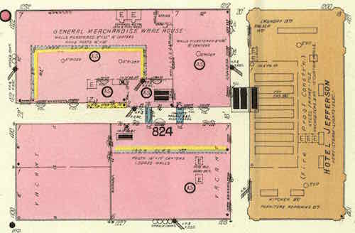
From the Feb 1909 Sanborn map we see the 1904 original on the right, the remaining brick structures on the block (pink) would all be razed within a decade. Click image to view source map.

Page 35

Ground was broken in mid-March, 1903, by Westlake Construction Co. and by May two shifts of crews working sixteen hours a day had pushed construction forward sufficiently to create a “steel forest” on Twelfth Street. The city’s broadest street, spanning a width of 150 feet, Twelfth (Tucker) had long been envisioned as a grand boulevard of monumental buildings likened to “what Unden der Linden is to Berlin, the show street of the city, because of its amplitude.”However, there was little evidence of the street’s potential before the tum-of-the-century. The completion of the new thirteen-story hotel commanding a full blockface on Twelfth thus promised at last to make the thoroughfare, “an ideal urban picture, the centerpiece of St.Louis as a metropolis…especially at night with electric lights reflected from damp pavements.”

Page 36

The hotel proper opened for guests on April 29 [1904], the eve of opening day of the fair. Registered dignitaries included the official delegation ofmembers ofthe U. S. Senate which, along with delegates from the House, represented the federal government at the opening ceremonies in the absence of President Theodore Roosevelt who telegraphically signaled the opening from his office in the White House. Suites ofrooms were also reserved for large state delegations from Ohio and Pennsylvania, and for numerous foreign noblemen. During fair year, the hotel served as headquarters for the Democratic National Convention as well as various other conventions, associations, and clubs.9

In 1916, the Hotel Jefferson again hosted the Democratic National Convention, this time leading to the second term of President Woodrow Wilson. The hotel’s sumptuous lobby,dining and cafe rooms also became favorite nightspots for local citizens. The opening in 1910 of the neighboring Shubert Theatre (later called the Jefferson Shubert) located across Locust Street in the Union Electric Building (demolished) attracted the after-theater crowd. A visiting traveler’s description in 1916 evokes something of the character of the hotel then: “we went over to the Jefferson to see society there … at midnight things begin to wake up at the Jefferson. Dozensoflimousinesunloadgladragsfullofhumanitywhowanttoeatand drink after the theaters. They used to employ artists to sing and dance for the guests but now, a space in the dining room is reserved and a part of the lobby is railed off so the guests themselves can dance between courses…They seem to have a lovely time and I wished I could be in ‘that element’.”

Page 38

The Jefferson Plaza Garage (Photos # 5, 6; Figs.16, 17, 18), erected in 1928 at the same time as the hotel annex, featured a facade of unusual architectural interest for garages of the period. Most garage facades of the 1920s (and later) in St. Louis displayed either structural concrete or standard red brick facing with little attempt at art. The materials ofthe primary (west) facade (along with the brick side elevations) ofthe Jefferson Plaza Garage matched the hotel annex’s buffbrick and cream terra cotta materials while respectfully addressing significant neighboring buildings on North Thirteenth Street such as the Shell Building (1925), Leopold Eidlitz’s Christ Church Cathedral (1859-67, NHL), and Cass Gilbert’s St. Louis Public Library (1910). The architects of record for the garage, Gill & Jackson (St. Louis), were assisted by W.J.Knight&Co.(St.Louis), consulting engineers specializing in reinforced concrete construction.

The garage’s utilitarian interior of exposed reinforced concrete construction exhibits a plan based on Fernand d’Humy’s 1919 patent for short,easy-graderampsandstaggered,split-levelfloors(Fig.16).The d’Humy patent, transferred to the Ramp Buildings Corporation (New York) which licensed use ofthe ramp system, became the standard design feature ofthe modern multi-level car park; the new building type offered quick and easy car access, an improvement over elevator garages ofthe 1920s. The six-story Jefferson Plaza Garage, originally accommodating 600 cars, was financed and built by St. Louisan William King who purchased the building lot from Hotel Jefferson interests in 1927 with the intent of collaborating with the hotel plans for expansion and upgraded service. While construction was in progress it was announced that the hotel and garage would be connected at the second story “so that tourists can drive directly to the garage and have no inconvenience from their luggage.” In 1924, William King, the former general manager of the Automobile Club of Missouri, had begun construction of the first of a series of four downtown commercial garages (all razed except the Jefferson Plaza) “in the hope ofrelieving parking and traffic congestion.” 

The garage faces 13th Street, across the street is Lucas Park. Barely visible is the Shell Building (right)

The nomination is great reading and it has great photos. You can see see recent images of the abandoned ballroom here.

I like that Alterra International is actually international — based in Turkey — with projects worldwide. The founding partner seems well-educated:

Mr. Sarimsakci holds a Masters’ degree from Stanford University’s Structural Engineering Department, and received his bachelor of science degree in Civil Engineering from Colorado State University. He is fluent in English, Russian, and Turkish.

They’re finishing up converting the Butler Brothers warehouse in Dallas into a hotel & apartments — maybe we can interest them in taking on our Butler Brothers warehouse?

— Steve Patterson


Autonomous Cars, Urban Planning, Public Transit

February 25, 2016 Featured, Planning & Design, Politics/Policy, Transportation Comments Off on Autonomous Cars, Urban Planning, Public Transit
 

Two weeks ago today I attended a Economic Club of Chicago luncheon — the guest speaker was Lex Kerssemakers, President & CEO of Volvo Car USA. His words got me thinking about driverless cars and the implications for cities in the future.

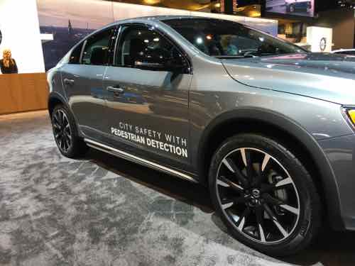
Volvo S60 with pedestrian detection at the 2016 Chicago Auto Show, click image to see Volvo's vision for autonomous cars
Volvo S60 with pedestrian detection at the 2016 Chicago Auto Show, click image to see Volvo’s vision for autonomous cars

In December Elon Musk said in two years a new Tesla will be able to drive itself.

As I began to research the topic I found varying thoughts on the future:

Whether self-driving cars reduce harmful emissions or the amount of land, energy, money, and other resources consumed by the transportation system depends largely on whether they reduce car ownership and driving. Optimists envision a future where driverless cars lead to a revolution in shared urban mobility. Why own a car when you can summon one to pick you up while avoiding the worries of parking, insurance, or maintenance?

In this scenario, the shift in ownership will also encourage payment based on miles driven and time of day rather than lumpy vehicle purchases, insurance fees, and parking. Instead of thinking about how much gas is in the tank, travelers will now consider the full marginal cost of a car trip when deciding whether to walk, bike, drive, or take transit. Transit service may also improve as a result of shared cars and minivans operating on fixed and flexible routes.

The biggest opportunity for improvement is in cities and neighborhoods where densities are currently too low to justify frequent bus or rail service. If shared or public, self-driving cars will dramatically reduce the demand for parking. Even privately owned vehicles will drop off passengers at front doors before driving off-site or behind a building to park, thus decoupling parking from other urban land uses. This would allow cities to dedicate more space to housing, shops, and offices, as well as stormwater management, street trees, and other sustainable features.

Pessimists, by contrast, see vehicle automation as one more technology that makes driving more comfortable and convenient and thus increases the amount that people drive. In this scenario, most households will own one or more self-driving cars, send their vehicles to run errands, circle to avoid paying for parking, and treat travel as if it had zero or very low time costs.

Many cars may become full-time mobile offices, whisking people between meetings, and the number of workers commuting between metropolitan regions will almost certainly increase. Making long commutes more productive will support the growing trend in long-duration commutes. Between 1990 and 2010, the proportion of commuters traveling more than 60 minutes and more than 90 minutes to work increased from six to eight percent and 1.6 to 2.5 percent, respectively.

Self-driving cars will also expand personal mobility for the third of the population without drivers’ licenses and the tenth of households without cars due to age, disability, low income, or preference. A demonstration video of one of Google’s prototype self-driving cars features a legally blind man riding to a Taco Bell in a self-driving vehicle.

Expanded access to cars may be particularly important for the nation’s elderly, many of whom live in and would like to remain in car-dependent communities. In this scenario, even if self-driving cars double existing capacity, this capacity will fill quickly — encouraging dispersed development and greater land consumption, which would further erode any sustainability benefits from increased efficiency. (When Autonomous Cars Take to the Road — American Planning Association)

No doubt there will be unintended consequences — both good & bad. Even as the technologies get closer to reality few cars on the road will be so equipped. It’ll be interesting to watch changes as more and more cars can drive themselves.

Further reading:

You can watch Lex Kerssemakers talk to the Economic Club of Chicago luncheon here — was on 2/11/16.

— Steve Patterson

Advertisement


[custom-facebook-feed]

Archives

Categories

Advertisement


Subscribe