Nineteen year ago I started this blog as a distraction from my father’s heart attack and slow recovery. It was late 2004 and social media & video streaming apps didn’t exist yet — or at least not widely available to the general public. Blogs were the newest means of …
The new NGA West campus , Jefferson & Cass, has been under construction for a few years now. Next NGA West is a large-scale construction project that will build a new facility for the National Geospatial-Intelligence Agency in St. Louis, Missouri.This $1.7B project is managed by the U.S. Army …
Book publisher Island Press always impresses me with thoughtful new books written by people working to solve current problems — the subjects are important ones for urbanists and policy makers to be familiar and actively discussing. These four books are presented in the order I received them. ‘Justice and …
This post is about two indirectly related topics: the new Siteman Cancer Center building under construction on the Washington University School of Medicine/BJC campus and an update on my stage 4 kidney cancer. Let’s deal with the latter first. You may have noticed I’ve not posted in three months, …
The Metropolitan St. Louis Sewer District wants to spend $13.5 million of its own money to tear down vacant properties. Grassy lots would let stormwater slowly percolate into the ground instead of rushing into the combined sewer system that serves much of St. Louis.
While it could take several years to spend down the money, even the longest spending scenario would amount to a near doubling of St. Louis’ demolition budget. And areas where MSD sees the most benefit in terms of runoff and watersheds also are the areas – primarily in north St. Louis – where the city’s vacant properties are concentrated. (Post-Dispatch)
So I want to know if this is something you support or oppose?
This unscientific poll will remain open until 8pm.
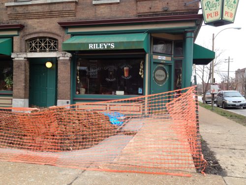
Five years ago, on January 2 2011, the City of St. Louis went smoke-free — with the exception of casinos and existing small bars that met certain conditions. Since then, some small bars that qualified for the exemption opted to go smoke-free.
During the 2007 Spring elections I attended a 6th ward campaign event at Riley’s Pub, 3458 Arsenal — it was so full of smoke I could hardly breathe. Back then the space out front was just an expanse of concrete and a couple of railroad tie planters — see on Google Street View. Due to the small size, Riley’s Pub qualified for an exemption — indoor smoking could continue. Not long after the smoking ban went into effect, Riley’s began turning the space out front into a proper patio.
Patio construction underway in December 2011
I’ve seen the new patio, but not photographed it. Even though it is finished, smoking is still allowed inside — until Saturday that is. A few days ago Riley’s Pub posted the following on their Facebook page:
If you don’t like to be around the smoke, you soon will be able to breathe easier at Riley’s. But if you are a smoker, consider stopping by New Year’s Eve or Day for a few last drags in the civilized indoors.
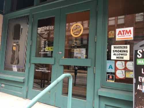
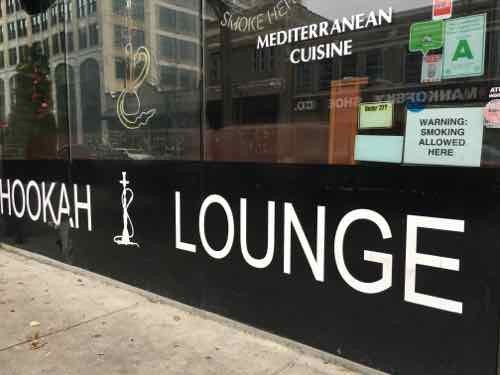
Unlike Riley’s, two downtown exempt bars don’t mention the expiration of the exemption. I checked the website & Facebook page of Stanley’s Cigars — no mention. Same for the website & Facebook page of Nara Cafe and Hookah Lounge.
Stanley’s Cigars
Nara Cafe & Hookah Lounge
I think many places will be caught off guard — even though they’ve had five years to prepare. Will they fight the exemption expiration? Will they pay fines? Decide to close rather than change? We will soon find out.
Please have a safe New Year’s Eve, see you again 8am Sunday morning for the first poll of 2016.
UPDATE 12/31/15 @ 11:20am:
The situation changed after I wrote this post:
Trophy Room owner Herbert Krischke filed suit on Christmas Eve, asking a judge to block the city from enforcing the ordinance or declare it unconstitutional. In part, the suit argues that the law “grants a special or exclusive right, privilege or immunity” to casinos such as Lumière Place, which would keep its exemption. Bar owners say that sets a double standard.
Dowd issued the restraining order Wednesday because he wanted to schedule a full hearing on the matter, which has been set for 10 a.m. Jan. 11, according to Thom Gross, court spokesman for the 22nd Judicial Circuit. Krischke and other city bar owners believe they’ve found a loophole to the existing law. (Post-Dispatch)
I’d like the courts to invalidate the exemption for gambling areas.
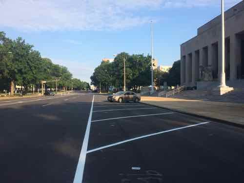
December 30, 2015DowntownComments Off on Readers Oppose Closing Chestnut at Soldiers Memorial
We’ll soon see proposals for Soldiers Memorial, they will apparently keep traffic open — just narrow the Chestnut roadway considerably.
Chestnut in front of Soldiers Memorial
Not only should Chestnut be narrowed, it should also be made two-way — at least between Tucker (12th) and 20th. Pine, the other part of this one-way couplet, should also be made two-way.
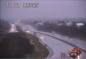
From a MoDOT camera, trucks in lower right used to close I-70
Record rainfall has resulted in flooding in the region, notably St. Charles County. On Sunday a major interstate highway was closed in both directions:
Both directions of Interstate 70 remain closed in St Charles County near Route 79 in St Peters due to rising flood waters from the Dardenne Creek. The eastbound lanes closed around noon Sunday, December 27 and the westbound lanes closed around 2:30 p.m.
It is expected that both the eastbound and westbound lanes will remain closed for Monday morning rush hour traffic.
Motorists who need to use eastbound I-70 in St Charles County can exit at Interstate 64 eastbound to Route 364 eastbound. Route 364 connects to Interstate 270 in St. Louis County and from there motorists can reconnect to Interstate 70. Westbound I-70 travelers will have to exit the highway at Route 94 in St Charles. They can take westbound Route 94 to westbound I-64 to connect back to I-70. (MoDOT)
The Dardenne Creek watershed flooded onto the interstate:
A watershed is an area of land where the runoff from rain or snow will ultimately drain to a particular stream, river, wetland or other body of water. There are nine major watersheds in the St. Louis region which drain into the Mississippi River and the Missouri River. Nested within these watersheds can be found smaller watersheds of creeks or streams and those segments of land which drain directly into the nine major watersheds. The following sections delineate the watersheds in the St. Louis region, discuss watersheds and watershed based natural resource planning and describe the actions the general public and local governments can take to improve water quality in their watersheds. (East-West Gateway Council of Governments)
While the record rainfall is big factor in the flooding, we can’t continue to ignore the role of urbanization plays. The better term, however, is suburbanization. Low density development with lots of rooftops, parking lots, and wide roads to connect it all. Coupled with dramatic population growth, too much of the county is paved over.
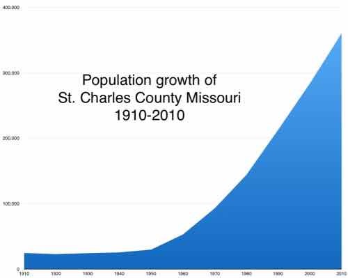
Here is the population of St. Charles County, per decade, with the percentage of growth from the previous.
1910 24,695 0.9%
1920 22,828 ?7.6%
1930 24,354 6.7%
1940 25,562 5.0%
1950 29,834 16.7%
1960 52,970 77.5%
1970 92,954 75.5%
1980 144,107 55.0%
1990 212,907 47.7%
2000 283,883 33.3%
2010 360,485 27.0%
Below is the visual:
Graph made from figures on Wikipedia, click image to view page.
Urbanization, a common land use/land cover (LULC) change in suburban areas, has become a significant environmental concern in the United States. Urban areas are continuously increasing at an alarming rate (22.7 ha per hour in 1982–1997) as reported by the U.S. Environmental Protection Agency (EPA) (USEPA, 2009). Although it provides enormous social and economic benefits, urbanization creates a significant amount of impervious surface by converting vast area of croplands, for- ests, grasslands, and wetlands into urban uses. The conversion alters natural hydro- logic processes and results in profound environmental consequences within a watershed, such as increasing the volume and rate of surface runoff and reducing ground water recharge (Carter, 1961; Andersen, 1970; Lazaro, 1990; Moscrip and Montgomery, 1997; Tang et al., 2005). Expanded impervious cover also reduces runoff lag time and increases the peak discharge of stream flow, resulting in larger and more frequent incidents of flooding (Field et al., 1982; Hall, 1984) and subse- quent increases in the scouring and incision of streams (Leopold, 1973; Booth, 1990; Doyle et al., 2000). Furthermore, the increase of impervious surface area degrades water quality of the stream, which is a major transporter and concentrator of pollutants (such as nutrients, heavy metals, and pesticides) in runoff and sedi- ments (Schueler, 1995). Percent impervious surface area in a watershed has been used as an important indicator of the ecological and environmental conditions of an aquatic system (Schueler, 1995; Arnold and Gibbons, 1996).
The Dardenne Creek watershed in St. Charles County, a suburb of St. Louis, Missouri, has experienced significant urban expansion in past decades. Events such as road overtopping in 2005 as a result of the highest flood level recorded since stream gages were installed in 1999 (U.S. Army Corps of Engineers, 2007) have focused public attention on the need to understand how the pattern and magnitude of past LULC change have impacted runoff, and how future development and miti- gation might change watershed hydrology. The aim of the work reported here was to provide a quantitative assessment of the impact of past urbanization on surface runoff, and a baseline calibrated model for future efforts to assess potential hydro- logical impacts of new urban development and LULC change.
In the lower portion of the watershed, both forests and agricultural lands decreased from 1982 to 2003, although the rate of decrease became lower after 1987. Corresponding to the decrease of these two LULC classes, urbanization was apparent between 1982 and 2003. In 1982, urban areas only covered 7.4% of the area. After that, they increased at approximately 2.1% per year and became one of the dominant classes in 2003 (50.5%) (Figs. 3B and 3D). LULC change in the upper portion of the watershed was less dramatic (Figs. 3C and 3D) because of its remote location from the metropolitan area. Forest cover in the upper portion was higher than in the lower portion. Forest cover decreased 11.2% from 1982 to 1987 and tended to be stable in the following years. Different from the lower portion, agricultural lands increased from 1982 to 1991, a possible correspondence of deforestation. Agricultural lands decreased after 1991 at a much lower rate than that in the lower portion. Urbanization in the upper portion was limited. Urban areas were only 0.4% in 1982 and gradually increased to 10.9% in 2003.
Results indicated that the watershed experienced rapid urbanization from 1982 to 2003. Urban areas increased from 3.4% in 1982 to 27.3% in 2003 in the whole watershed. Urbanization dominated in the lower portion of the watershed and gradually migrated to the upper watershed due to the proximity to the metropolitan area of the city of St. Louis. As a direct result of the urbanization from 1982 to 2003, the long-term surface runoff increased >70% for the whole watershed (>95% and >48% in the lower and upper portion of the watershed, respectively). The runoff increase was highly correlated with the percentage of urban areas (R2 > 0.90). Cou- pled with significant flooding events in 1993 and 2005, this work helps raise aware- ness of the actual scale of hydrologic impacts of urbanization in this particular watershed, and provides a simple calibrated tool for local planners to use in assess- ing potential impacts of future development and mitigation activities. More generally, such case studies provide important insight both into the scale of impact of complex land-use change and into approaches that can be used to evaluate, plan, and manage watersheds.
So what can be done about it now, isn’t it too late? No!
I’ve talked about Retrofitting Suburbia before. Architect Ellen Dunham-Jones suggests, in her TED talk, we can daylight creeks, rebuild wetlands, etc. The solution is to literally urbanize some suburbanized areas, while returning others to rural, wetlands.
However, I seriously doubt the conservative electorate in St. Charles County is willing to do what is necessary. Flooding will likely continue.
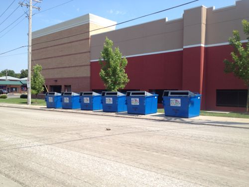
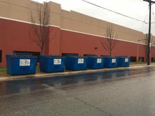
Over two years ago I posted about recycling dumpsters blocking a public sidewalk on the West side of Target, At the time Clifton Ave was being resurfaced so I wasn’t sure if they were on the sidewalk temporarily.
September 2013: The six recycling bins, oriented to the street, viewed from across Clifton Ave
In the time since I’ve noticed them still on the sidewalk, but I was passing by on Chippewa and couldn’t get a picture. Yesterday, Target had the Chippewa entrance to the lower level parking closed, so we turned onto Clifton Ave. — so I stopped the car to get a pic.
December 27, 2015. Click image to view in Google’s Street View
Recycling is important, but so are pedestrians! All pedestrians should be able to go from Chippewa to Bancroft — that’s why the sidewalk exists.
Here’s what needs to happen:
Move the bins into the street, OR
Add more sidewalk behind the bins, OR.
Relocate the bins elsewhere
I’d love to know who made the decision to block the public sidewalk.
AARP Livibility Index
The Livability Index scores neighborhoods and communities across the U.S. for the services and amenities that impact your life the most
Built St. Louis
historic architecture of St. Louis, Missouri – mourning the losses, celebrating the survivors.
Geo St. Louis
a guide to geospatial data about the City of St. Louis