Nineteen year ago I started this blog as a distraction from my father’s heart attack and slow recovery. It was late 2004 and social media & video streaming apps didn’t exist yet — or at least not widely available to the general public. Blogs were the newest means of …
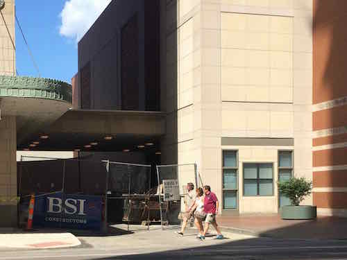
The new NGA West campus , Jefferson & Cass, has been under construction for a few years now. Next NGA West is a large-scale construction project that will build a new facility for the National Geospatial-Intelligence Agency in St. Louis, Missouri.This $1.7B project is managed by the U.S. Army …
Book publisher Island Press always impresses me with thoughtful new books written by people working to solve current problems — the subjects are important ones for urbanists and policy makers to be familiar and actively discussing. These four books are presented in the order I received them. ‘Justice and …
This post is about two indirectly related topics: the new Siteman Cancer Center building under construction on the Washington University School of Medicine/BJC campus and an update on my stage 4 kidney cancer. Let’s deal with the latter first. You may have noticed I’ve not posted in three months, …
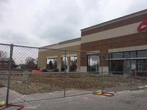
In November I posted about the first Lucky’s Market in our region — occupying a space in Ellisville built by Straub’s just a few years before. If you haven’t heard of Luckty’s Market before:
The Lucky’s Market chain was started by a husband-and-wife team 12 years ago in Colorado. As two chefs, the couple wanted a grocery store for food lovers like themselves, so they opened their first store in 2003 to sell specialty foods at affordable prices.
“We really work to meet people on their personal food journey by simply making natural foods more accessible, and doing so in a comfortable and welcoming store environment,” said Krista Torvik, a representative of Lucky’s Market.
Lucky’s sells “never ever” meats, which have never been treated with antibiotics or artificial growth hormones. In addition, customers will be able to find local produce, fresh seafood and baked goods (like maple bacon doughnuts!), alongside bacon that’s been cured and smoked in-house and homemade sausage.
The market also offers ready-to-eat meats, salads and sides that are made in-store daily, plus fresh juices and smoothies at its juice bar.
For shoppers’ convenience, Lucky’s Market still sells consumer favorites like Coca-Cola and Campbell’s soup, and the store has a bulk items section. (Ft. Lauderdale Daily)
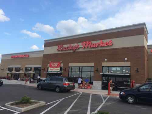
The company originally planned to open the Rock Hill store in the first quarter of 2014, but was delayed while the developer, Webster Groves-based Novus Development Co., worked out a funding agreement including a community improvement district with the city.
In the year of delay, the store added over 12,000 square feet to the building plans, Chief Growth Officer Mike Phillips said. Though the company would not disclose construction costs, Vice President of Marketing Ben Friedland said it kept costs as low as possible by using refurbished and used equipment and materials in order to give customers the low prices the grocer advertises. (St. Louis Business Journal)
This is their 13th location nationwide.
The Rock Hill Lucky’s Market during the building expansion in November 2014.
For 5 years in the early 1990s I worked for a general contractor out of his house located exactly where this store is now! The Schnucks at Manchester & Brentwood is a mile to the East, a Dierbergs Market is a mile to the West — it opened when I worked in the area.
Monday we attended the soft opening as guests of a personal friend who works there. The store opened on Wednesday.
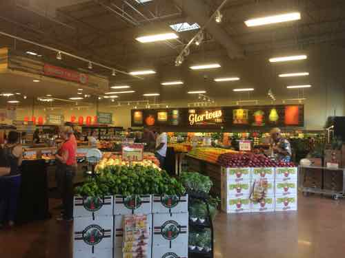
Inside the new Lucky’s Market
With this Rock Hill location Lucky’s Markets operates 13 stores in 10 states. Five more locations are “coming soon” including one in an 11th state.
By comparison, Trader Joe’s has 457 locations in 39 states and Washington D.C., Whole Foods has 408 locations in 42 U.S. states. In February 2013 Whole Foods announced a 3rd St. Louis area location, in the Central West End. It was supposed to open by this Fall — but will now open in 2016.
On the other end of the scale, we have local stores like Local Harvest & Fields Foods in the City of St. Louis. It would be interesting to compare the selection & prices at these local stores to places like Lucky’s Market & Whole Foods.
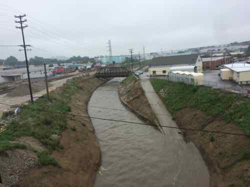
One hundred years ago today St. Louis experienced deadly flooding. The problem wasn’t the Mississippi, it was the River Des Peres!
On the afternoon of Aug. 19, 1915, remnants of a hurricane reached St. Louis from Texas. Heavy and steady rainfall fell through the next day, dumping a total of 7.4 inches across the area. (6.85 inches on Aug. 20 remains the one-day record in St. Louis.)
The River Des Peres rushed from its banks, swamping long stretches of Delmar and Lindell boulevards, Manchester Avenue and other streets. People were stranded on the Wabash Railroad platform at Delmar (now a Metrolink station) by a seven-foot-deep current 200 yards wide. Firefighters reached them with ladders and used boats to rescue residents of Maple and Hodiamont avenues. (St. Louis Post-Dispatch — includes vintage photos)
In August 1915, St. Louis was flooded. All roads leading to the suburbs were cut off, and in Maplewood, the waters reached the second floor of some homes. The water was a mile-wide in Forest Park. Three bridges in the park were washed away, the Zoo’s Bird Cage and Bear Pits were flooded. The platforms at the old Delmar Station were destroyed. Passengers at the Wabash Station were surrounded by seven feet of water and had to be rescued by firefighters. Other people were trapped in their homes, and some even drowned. By the time the disaster was over, 11 people had died and more than 1,000 homes were lost.
The cause of the disaster was not the Mississippi River but the smaller River Des Peres, which ran along the City’s western edge.
River Des Peres, or “River of the Fathers,” was named after two Jesuit priests who founded a mission on its banks around 1700. Problems associated with flood and sewage control became obvious as St. Louis grew. In 1887, city officials planned to drain River Des Peres and Mill Creek. This plan was not completed, though, and River Des Peres had become an open sewer by the early 1900s. Parts of the river were covered or diverted in preparation for the World’s Fair in 1904, and monitoring of flooding conditions began in 1905. However, no steps had been taken by 1915 that could have prevented the devastating flood that same year. (St. Louis Public Library)
Perhaps the first sewage the River des Peres received was from St. Louis’ Central West End chamberpots. In response to the volume of waste, the city wrote an ordinance in 1887 “to prevent discharge of sewerage or offensive matter of any kind into the River des Peres.” If the city had funded the ordinance, then a separate sewer system would have been built and the River des Peres’ history might have taken a different course. Instead, the government of St. Louis began a trend that has plagued the river for more than a century: St. Louis would support ideas to protect the River des Peres as a sewer more than as a river.
As St. Louis grew westward, so did the expanses of pavement. With less open ground to soak up the rains, the River swelled with runoff. The River des Peres flooded in 1897, 1905, 1912, and 1913. The flood of 1915 killed 11 people and forced 1025 families from their homes. Flooding – not sewage – prompted St. Louisans to action. Mayor Henry W. Kiel called for a hydrologic study, which was completed by W.W. Horner and presented to the St. Louis Board of Public Service in 1916. St. Louis voters chose to implement Horner’s recommendations, which cost $11 million.
The project was called the River des Peres Sewerage and Drainage Works, and it took nine years to complete (from 1924 to 1933). Workers re-graded and paved the River’s banks and straightened its bends. Elsewhere the River was directed below ground to join with the sewer. The engineering innovations brought national recognition for Horner (who was also the project engineer). Scientific American and Engineering News-Record featured the marvelous new River des Peres. In 1988, the American Society of Civil Engineers recognized the project as a National Historic Civil Engineering Landmark. (River Des Peres Watershed Coalition)
The bond issue vote was in 1923 — 7 years after the plan was presented.
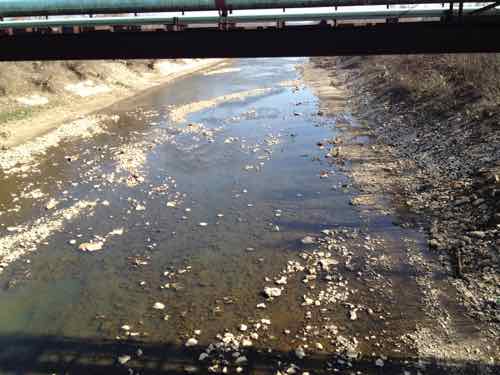
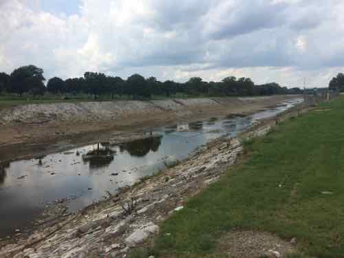
River Des Peres at S. Broadway, March 2012
River Des Peres, looking East from Hampton, July 2015
River Des Peres; looking North from Gravois. Tuesday August 18, 2015
Problem solved? Wrong.
Explore any city enough, and at some point you’re likely to walk on water, so to speak. San Francisco is full of ghost rivers. So are Washington, D.C. and Los Angeles. In the urban core of Baltimore, up to 98 percent of streams are underground.
Early city planners may have hoped for healthier cities when they covered up these streams, but it turns out they created new problems. Paving over and piping waterways often worsens flooding. And as new research by scientists at the Environmental Protection Agency indicates, buried streams can also exacerbate pollution.
In a paper published in PLOS ONE, lead authors and EPA research scientists Jake Beaulieu and Heather Golden found that nitrates—nutrients that can become pollutants—travel on average 18 times further in buried urban streams than they do in open streams, before they are taken out of the water column. (City Lab)
From February 2014:
Starting in a few days, MSD will begin construction of a 3,028 foot-long tunnel under the River Des Peres, just south of Carondelet.
The tunnel will hold a pressurized pipe that will carry sewage to the Lemay Wastewater Treatment Plant.
MSD spokesperson Lance LeComb said the new pipe will increase the plant’s capacity to take in sewage, and also serve as a back-up in case the existing “force main” ? which dates back to the 1960s ? has a problem.
The project is the first of about a dozen tunnels, totaling nearly 33 miles in length, that the MSD will be digging under St. Louis in the next couple decades. Most of the tunnels will hold a mix of stormwater and sewage. “The longest one will be nine miles long, running underneath the River Des Peres, almost 200 feet below ground,” LeComb said. “And 30 feet in diameter.” (St, Louis Public Radio)
Hopefully this will keep our sewage out of the waterways and not create more problems! The River Des Peres starts in St. Louis County, flash flooding remains an issue.
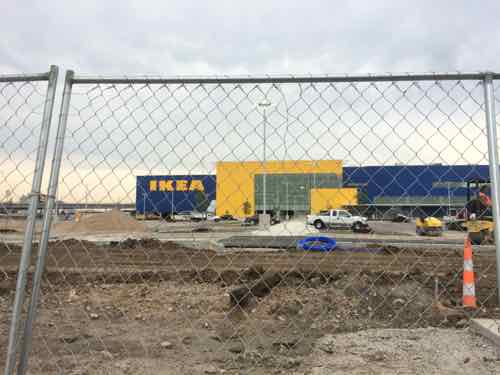
In the recent Sunday Poll a solid majority (68.63%) indicated — no surprise — positive feelings about IKEA opening soon. Those who were neutral outweighed the negative, 19.61% vs 11.76%.
I don’t like that it’s set back from Forest Park Blvd, but glad they’ll have two wide walkways from the public sidewalk through the parking lot to reach the entry.
I’ve shopped at 7 different IKEA stores over the last 25 years, always while traveling. This will be a new experience being able to go anytime I want. As rumors of the store were circling a few years ago I said, as a big box, it belonged in suburbia. I still feel that way. It lowers the bar for the redevelopment of the area. I can only hope that so many others want to locate in close proximity that everything about the IKEA is more urban than the IKEA itself.
Here are the results:
Q: How do you feel about IKEA St. Louis opening in 45 days:
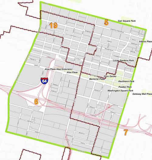
Technically Downtown, a city neighborhood, is only East of Tucker Blvd (12th). So much of what we think of as downtown is considered Downtown West.
Map of Downtown West Neighborhood bounded by Chouteau, Jefferson, Cole, & Tucker; click image to view on city website
All of the following are located not in Downtown, but in Downtown West:
Police Headquarters (old & new)
City Hall
Peabody Opera House
Scottrade Center
Main U.S. Post Office
Soliders Memorial (WWI)
Central Library
City Museum
Campbell House
Downtown YMCA
Union Station
Schlafly’s Tap Room
Civic Center MetroLink/MetroBus
Transportation Center (Amtrak, Greyhound, Megabus)
But I don’t want news reporters outside police HQ to say “Reporting from Downtown West”, I think we should combine the two.
From a 1989 Post-Dispatch article:
SECTIONS OF St. Louis have an identity crisis, says Mayor Vincent C. SchoemehlJr. ”There’s this impression that north St. Louis is some monolithic area that’s unfit to live in,” Schoemehl said. ”Frankly, there’re some very good neighborhoods in north St. Louis, as good as any around. But when you hear about a murder or a rape or some other crime occurring in north St. Louis, all the neighborhoods in north St. Louis become tarred with the same brush.” The identity crisis has sparked a campaign, beginning this week, that stresses neighborhoods – 74 to be exact. No longer will there just be the North Side, the South Side, the Central West End or downtown. ”This is one of our attempts to market the neighborhoods of the city,” said Clara Kinner, director of communications for the city’s Economic Development Corp. ”People should understand that there are several different neighborhoods with several different personalities and attributes,” she said. Many, but not all, of the new neighborhood boundaries will coincide with the boundaries set by existing neighborhood associations, Kinner said. (P4, October 15, 1989)
So when the city first created the neighborhood map it had 74 neighborhoods, but currently it is 79:
There are 79 different neighborhoods, each with its own distinctive style and characteristics. Many of these neighborhoods have very active community organizations and associations. Some are on the rebound, while others have remained stable for decades, and still others are striving for renewal. A variety of sources for information about neighborhoods exist, both on and off this website. None of these sources include everything there is to know about a neighborhood, but by putting together information from each of these sources, one may get a sense of the incredible variety of lifestyles available in the diverse neighborhoods of the City of St. Louis. (St. Louis Neighborhoods)
Now you might be wondering if the Downtown West neighborhood association would object to being consolidated with Downtown’s NA. Well, there has never been a separate Downtown West neighborhood association. The Downtown Neighborhood Association boundaries had included all of Downtown and about half of Downtown West, but last month their bylaws were amended to expand their boundaries to match both.
The Downtown Community Improvement District boundaries also includes much of Downtown West. Just because people in 1989 wanted to better identify where murders happened doesn’t mean we can’t alter the map 26 years later. It’s time to reduce the 79 neighborhoods to 78!
After being shuttered since 2011, the original Hotel Lennox – once known as St. Louis’ tallest hotel – will re-open Sept. 2, the same day that the hotel originally opened in 1929, as The Courtyard by Marriott St. Louis Downtown/Convention Center Hotel. The newly revitalized hotel will be one of the most unique and historically significant Courtyard-branded hotels in the country. The hotel has undergone a significant renovation, with an investment of over $22M into the property during a 16-month restoration. (KMOX)
Los Angeles-based Maritz Wolff & Co. will own and manage the property. It bought the Renaissance Suites this year for $3.2 million from the bondholders who owned it. Lewis Wolff, co-founder and chairman of Maritz, Wolff & Co., and Phillip “Flip” Martiz, its co-founder and president, sold the Ritz-Carlton in Clayton for $56 million in December 2012 to Bruce Karsh and his Clayton St. Louis Property LLC.
The development and management team from Maritz Wolff is led by Patrick Lowery and Jeffrey Barone. (St. Louis Business Journal)
The narrow Washington Ave facade, 9th Street on the left. Our convention center is on the right.
Thankfully the renovations included the new sidewalks you can see above, replacing the failed stamped concrete fake brick sidewalk that was installed about 15 years ago, when it reopened as the Renaissance Suites. The sidewalk is totally new, but they did one thing exactly as it had been: the location of the curb ramp across the auto driveway to the East.
The sidewalk width is generous and people tend to walk in the center. But those of us using wheelchairs are forced to use ramps pointing diagonally into the street. This new work should’ve had a wide ramp area in the natural flow of pedestrian traffic, not a ramp pointing into the street out at the corner.
You might say they were just matching the ramp on the East side of the driveway. Two wrongs don’t make a right.
View looking West across driveway. In the winter snow gets piled up blocking ramps placed at the curb rather than the natural pedestrian flow closer to the buildings.
When new concrete is poured it should be done right, now continue an early 1990s mistake. If new work makes incremental improvements then eventually downtown will be more pedestrian-friendly.
This pedestrian crossing of Morgan St is a good example.
In high pedestrian areas such as between the hotel and convention center this reduces the chances someone will trip & fall on a curb. As this is part of the public right-of-way (PROW), not private property, the city should’ve ensured this was done differently.
AARP Livibility Index
The Livability Index scores neighborhoods and communities across the U.S. for the services and amenities that impact your life the most
Built St. Louis
historic architecture of St. Louis, Missouri – mourning the losses, celebrating the survivors.
Geo St. Louis
a guide to geospatial data about the City of St. Louis