Celebrating Blog’s 19th Anniversary


  Nineteen year ago I started this blog as a distraction from my father’s heart attack and slow recovery. It was late 2004 and social media & video streaming apps didn’t exist yet — or at least not widely available to the general public. Blogs were the newest means of …

Thoughts on NGA West’s Upcoming $10 Million Dollar Landscaping Project


  The new NGA West campus , Jefferson & Cass, has been under construction for a few years now. Next NGA West is a large-scale construction project that will build a new facility for the National Geospatial-Intelligence Agency in St. Louis, Missouri.This $1.7B project is managed by the U.S. Army …

Four Recent Books From Island Press


  Book publisher Island Press always impresses me with thoughtful new books written by people working to solve current problems — the subjects are important ones for urbanists and policy makers to be familiar and actively discussing. These four books are presented in the order I received them. ‘Justice and …

New Siteman Cancer Center, Update on my Cancer


  This post is about two indirectly related topics: the new Siteman Cancer Center building under construction on the Washington University School of Medicine/BJC campus and an update on my stage 4 kidney cancer. Let’s deal with the latter first. You may have noticed I’ve not posted in three months, …

Recent Articles:

As St. Louis Builds A Small Park Over A Highway…A Look At Dallas’ Klyde Warren Park

June 16, 2015 Featured, Parks, Travel 11 Comments
 

As work continues on the “lid” over the highway, now called I-44,  that divides downtown St. Louis from the Arch grounds I thought we should take a look at another recent park-over-highway project — Dallas’ Klyde Warren Park:

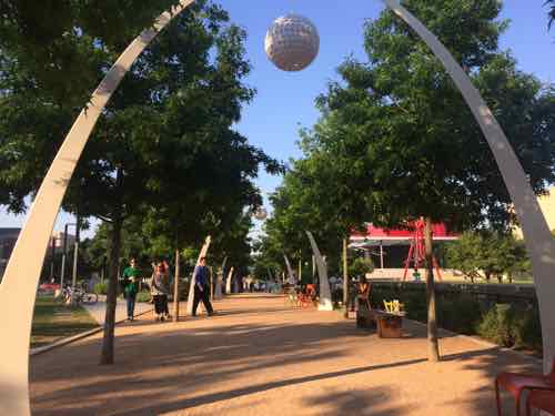
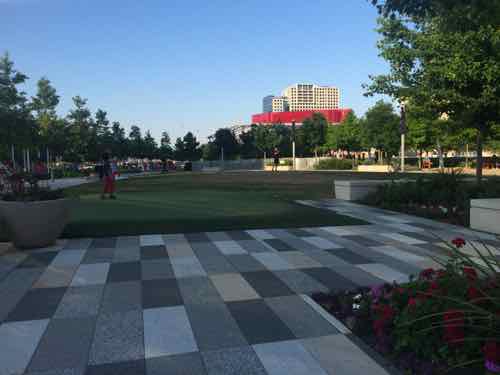
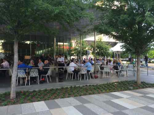
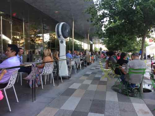
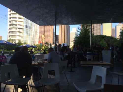
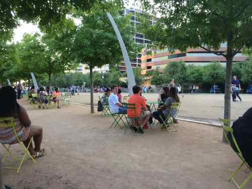
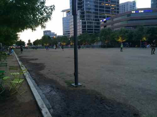
Klyde Warren Park creates an urban green space constructed over a section of the below-grade Woodall Rodgers Freeway, for 3 blocks between Pearl Street and St. Paul Street. It provides connectivity to the city’s flourishing Arts District from other neighborhoods, brings together cultural events and experiences, and serves as a central public gathering space for Dallas residents and visitors to enjoy.

Designed by landscape architecture firm, The Office of James Burnett, the park features flexible, pedestrian-oriented design, offering a mix of active and passive spaces, which include a children’s park, reading room, great lawn, restaurant, performance pavilion, fountain plaza, games area, urban dog park, and botanical garden around a sweeping pedestrian promenade.. A 6,000-square-foot (560 m2) restaurant and performance stage, designed by Thomas Phifer and Partners, is in the center of the park. In addition it provides jogging trails, a dog park, a children’s playground, and an area for games. (Wikipedia)

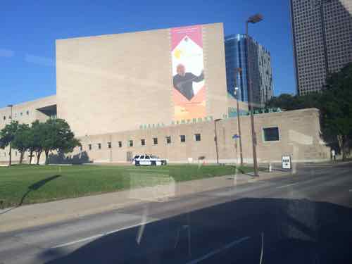
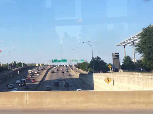
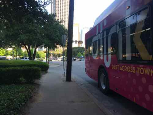
The idea of building a park over the recessed highway had been discussed since the highway was built in the 1960s. As an architecture student in the late 80s I visited I.M. Pei’s then-new Morton H. Meyerson Symphony Center in 1989, thinking the location, next to this wide ditch, was awful. Though I’d been to Dallas since then, I hadn’t seen the Meyerson again until last month.

26 years after seeing the new building, I passed by Dallas' symphony hall on their free D-Link bus.
26 years after seeing the new building, I passed by Dallas’ symphony hall on their free D-Link bus. Click image for map link.

The new trees are now mature, but unfortunately I didn’t have enough juice in my wheelchair to get closer. Besides, I was about to cross over the highway and in a block be at my destination.

Looking right I saw the highway that had long been a divider, the other direction was the new Klyde Warren Park
Looking right I saw the highway that had long been a divider, the other direction was the new Klyde Warren Park. View from Pearl St

Normally the D-Lkink bus would've crossed through the park on Olive but they close it during busiest times -- otherwise it's open.
Normally the D-Lkink bus would’ve crossed through the park on Olive but they close it during busiest times — otherwise it’s open.

Vehicles & the D-Link bus are rerouted when Olive is closed, but their vintage trolley line gets to cut through.
Vehicles & the D-Link bus are rerouted when Olive is closed, but their M-Line vintage trolley gets to cut through for obvious reasons. Click image for more information on this line.

This is like he 'hallway' our Gateway Mall is supposed to have, right now we only have 2 blocks in Citygarden
This is like he ‘hallway’ our Gateway Mall is supposed to have, right now we only have 2 blocks in Citygarden

Like Citygarden, this park has a botanical side. It's also city-owned but managed by a foundation.
Like Citygarden, this park has a botanical side. It’s also city-owned but managed by a foundation.

It's nearly 80% bigger the Citygarden, has more diverse areas as a result.
It’s nearly 80% bigger the Citygarden, has more diverse areas as a result.

The upscale restaurant was packed the Saturday night I was there,

Here you see people at the upscale restaurant (left) and regular park patrons sitting at movable tables & chairs located throughout the park (right).

The Congress for the New Urbanism/CNU23 closing party was at the self-serve end of the building

'Retrofitting Suburbia' author Ellen Dunham Jones invited me to join her to chat, we finally met the day before. We'd communicated via email for years.
‘Retrofitting Suburbia’ author Ellen Dunham Jones invited me to join her to chat, we finally met the day before. We’d communicated via email for years. Selfie without a selfie stick… Click image to view her 2010 TED Talk.

The restaurant building has restrooms accessed from the outside, but the capacity isn't enough &/or isn't visible enough. -- so porta-potties are added in a few parking spots.
The restaurant building has restrooms accessed from the outside, but the capacity isn’t enough &/or isn’t visible enough. — so porta-potties are added in a few parking spots.

Like St. Louis, they didn't think about how wheelchair users would reach the disabled john.
Like St. Louis, they didn’t think about how wheelchair users would reach the disabled john. #curb

The South block has a big open area where people can kick balls around, etc

The big open field
The big open play field

An area on the edge for parking, left, is used by many food trucks during events.

By planning ahead, the food tricks lined up here for hours can all plug into outlets rather than run noisy polluting generators. I was able to plug in  my chair, grab a bite, and people watch.
By planning ahead, the food tricks lined up here for hours can all plug into outlets rather than run noisy polluting generators. I was able to plug in my chair, grab a bite, and people watch.

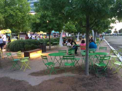
Of course, a 5.2 acre park built over a highway didn’t come cheap:

The $110 million project was funded through a public-private partnership. Public support included $20 million in bond funds from the City of Dallas, $20 million in highway funds from the state and $16.7 million in stimulus funds. The balance of funding is through individual donors directly to the Woodall Rodgers Park Foundation.

Klyde Warren Park is owned by the City of Dallas and privately operated and managed by the private Woodall Rodgers Park Foundation. The Foundation studied great public parks across the country and plans to bring best practices to the park’s operations, programming and maintenance.

I’d say it’s worth every penny! Over the coming 25 years it’ll help mend areas long-separated because of the highway. I love that the foundation must also program the space, wish the Gateway Foundation had to do the same at Citygarden, and that 9th Street would remain open except for during events/weekends.

— Steve Patterson


Two Sites Seeking Zoning Changes In Frontenac, Pushback From Residents


Currently there are a couple of interesting zoning issues in the affluent St. Louis suburb of Frontenac. First, some background:

Frontenac is a wealthy inner-ring suburb of St. Louis, located in St. Louis County, Missouri, United States. The signature landmark is Plaza Frontenac, a high-end mall featuring many prominent retailers such as Saks Fifth Avenue, Neiman Marcus, and Tiffany & Co., among others. The population was 3,482 at the 2010 census.

The community name is inspired by the Château Frontenac of Quebec City. Benjamin and Lora Wood, who laid out the community’s core called Frontenac Estates, that consisted of 26 two-acre estates, had made frequent trips to Quebec. The community was incorporated as 217 acres (88 ha) in 1947 and annexed another 967 acres (391 ha) in 1948. The community still consists mostly of houses on one-acre lots. French architecture is encouraged in design. (Wikipedia)

From the same Wikipedia page:

The median income for a household in the city was $119,508, and the median income for a family was $136,972. Males had a median income of $100,000 versus $47,344 for females. The per capita income for the city was $64,532. About 0.8% of families and 1.2% of the population were below the poverty line, including 0.6% of those under age 18 and 1.0% of those age 65 or over.

The majority of residences in Frontenac are large single-family detached homes on at least a one-acre lot. At Lindbergh & Conway there are a few blocks of smaller homes on small lots. The biggest exception to the single-family one acre norm is off the I-64 service road West of Spoede — the Daniel Boone Trailer Park. But this 1.31 acre site at 11130 S. Forty Dr isn’t involved in the two zoning issues.

The first is the nearby site of the former Ladue Early Childhood Center at 10601 Clayton Rd., Frontenac is in the Ladue School District. The second is the former Shriner’s Hospital for Children at 2001 S. Lindbergh, on June 1st their new hospital opened in the City of St. Louis.

10601 Clayton Rd

The vacant school  has 420 feet of frontage on Clayton Rd
The vacant school has 420 feet of frontage on Clayton Rd

Closer view of existing building

Some in Frontenac oppose a developer's plan to build a senior residence & villas on the site
Some in Frontenac oppose a developer’s plan to build a senior residence & villas on the site

Though zoned for one acre lots, this site and a few others West to Spoede Rd. are shown as “Single Family Residential – Planned (Overlay) ” on their future land use map. From page 8 of their 2006 Comprehensive Plan:

“Single Family Residential–Planned” is proposed as an overlay land use category. The intention of this is to recognize that the demand for housing options in the area is dynamic and to allow a degree of flexibility for the City of Frontenac to meet this demand. This district identifies areas within Frontenac where the type of residential development described below could easily fit into the fabric of the community. As an overlay, this district is only intended to be an acceptable alternative to the existing land use or the Future Land Use Plan. In addition to the specific areas identified on the map, land adjacent to and fronting on North Outer Forty Drive and South Outer Forty Drive has also been identified as appropriate for Single Family Residential– Planned.

Defined on the following page as:

Single family detached homes or 2-unit attached villas, clustered to maximize open space and allow for flexible home siting and property maintenance arrangements. Requires the creation of a new Planned Residential District as an Overlay District within the City’s Land Use Code of Ordinances.

More detail at the Frontenac Planning & Zoning Commission, see the latest revision to the proposal here.

2001 S. Lindbergh

When the Shriner’s moved their hospital to Frontenac in the early 1960s much of the small town was still undeveloped. Since then, McMansions on one acre lots have closed in on the 14.87 acre site with more than 600 feet of frontage on Lindbergh Blvd.

In 1962 the Shriner's built a new hospital on a large site in Frontenac
In 1962 the Shriner’s built a new hospital on a large site in Frontenac

With the new hospital open the old site can now be sold for redevelopment. From last month.

John Gloss, hospital administrator, said the property in Frontenac attracted 17 offers, which were then narrowed down to four and now one.

The buyer and the hospital are in a “due diligence” period with the buyer, which Gloss declined to identify, citing a confidentiality agreement. 

Robert Shelton, Frontenac’s city administrator, however, told the Post-Dispatch Wednesday “the buyer is DESCO.” (Post-Dispatch)

DESCO is the development company of Schnucks Markets, behind developments like Loughborough Commons and the 9th Street Garage — after razing the historic Century Building. My assumption is they’d like to build a new Schnucks to replace the old/small location at the NE corner of Lindbergh & Clayton in the City of Ladue.

Schnucks at 10275 Clayton Rd. in the Ladue West Shopping Center was built in 1959. The shopping center site is only 5.44 acres.
Schnucks at 10275 Clayton Rd. in the Ladue West Shopping Center was built in 1959. The shopping center site is only 5.44 acres. Click image for map.

Like the former school on Clayton Rd, the nearly 15 acre former hospital site is zoned one acre residential. However, Frontenac’s future land use plan shows it as Regional Commercial, the same as abutting Plaza Frontenac. Their 2006 Comprehensive Plan defines this as:

 Retail, office, and/or other commercial uses at a scale of regional service. 

I’ll be interested to see DESCO’s proposal for this site.

— Steve Patterson

Sunday Poll: Yesterday a Ohio man wanted to enter the St. Louis Zoo openly carrying his gun, thoughts?


Please vote in the poll, located in the right sidebar
Yesterst Please vote in the poll, located in the right sidebar

Last week a Cincinnati Ohio man announced he planned  to visit the St. Louis Zoo openly carrying a gun:

An Ohio man is planning to walk into the St. Louis Zoo with a gun Saturday.

Even though there are signs posted around the zoo stating that weapons are not allowed, Jeff Smith is planning to walk into the zoo with a gun visible to others, most likely in a holster or belt on his hip. Smith said he will demand to know what Missouri State Law he has violated if he is stopped from entering. (KMOV)

Local officials, including the police chief, looked for ways to prevent Smith’s plan:

St. Louis Police Chief Sam Dotson says Missouri has some of the most liberal gun laws in the country, and it may allow an open-carry protest to happen inside the zoo.

Amendment 5, was passed in August 2014, establishes the “unalienable right of citizens to keep and bear arms, ammunition and accessories associated with the normal functioning of such arms, for the purpose of defense of one’s person, family, home and property.”

Dotson says attorneys are looking to see if the amendment can allow police to keep the protest outside of the zoo. (KMOX)

Friday morning the St. Louis Zoo filed for a temporary restraining order, which was granted a few hours later:

A judge has barred a gun rights advocate from entering the St. Louis Zoo with a gun. (Post-Dispatch)

The poll today seeks to find out how regular readers feel about open carry of guns at the St. Louis Zoo. The poll answers might be a bit confusing, but they should cover all the various views. They’re presented in random oder. If you don’t like an answer you can provide your own. You can also share your thoughts in the comments below. The poll closes at 8pm — sooner if corrupted.

— Steve Patterson


June 12th: Loving Day

June 12, 2015 Events/Meetings, Featured, History/Preservation Comments Off on June 12th: Loving Day
 

Mildred & Richard Loving, 1967

At the end of this month the U.S. Supreme Court will rule on two questions of marriage equality with respect to LGBT people. Forty-eight years ago they ruled on the divisive marriage question of the day: marriage between whites & non-whites, mostly blacks:

Few cases were more aptly named than Loving v. Virginia, which pitted an interracial couple – 17-year-old Mildred Jeter, who was black, and her childhood sweetheart, 23-year-old white construction worker, Richard Loving – against Virginia’s “miscegenation” laws banning marriage between blacks and whites. After marrying in Washington, D.C. and returning to their home state in 1958, the couple was charged with unlawful cohabitation and jailed. According to the judge in the case, Leon M. Bazile, “Almighty God created the races white, black, yellow, malay and red, and he placed them on separate continents…. The fact that he separated the races shows that he did not intend for the races to mix.” Judge Bazile sentenced the Lovings to a year in prison, to be suspended if the couple agreed to leave the state for the next 25 years.

The Lovings left Virginia and went to live with relatives in Washington, D.C. When they returned to visit family five years later, they were arrested for traveling together. Inspired by the civil rights movement, Mildred Loving wrote to Attorney General Robert F. Kennedy for help. The couple was referred to the ACLU, which represented them in the landmark Supreme Court case, Loving v. Virginia (1967). The Court ruled that state bans on interracial marriage were unconstitutional. (Loving v. Virginia: The Case Over Interracial Marriage)

The court ruling is celebrated annually:

Loving Day is an annual celebration held on June 12, the anniversary of the 1967 United States Supreme Court decision Loving v. Virginia which struck down all anti-miscegenation laws remaining in sixteen U.S. states citing “There can be no doubt that restricting the freedom to marry solely because of racial classifications violates the central meaning of the equal protection clause.” In the United States, anti-miscegenation laws were U.S. state laws banning interracial marriage, mainly forbidding marriage between non-whites and whites. Loving Day is not yet an official recognized holiday by the U.S. government, but there is a movement to persuade U.S. President Barack Obama to make it so. Loving Day is the biggest multiracial celebration in the United States. (Wikipedia)

Additional resources:

If not for Loving v. Virgina, conservative Justice Clarence Thomas couldn’t live in or visit 17 states with his 2nd wife, but I expect him to vote again marriage equality later this month…he got his!

— Steve Patterson


Rethinking Chariton Square


In May of last year I posted about a drive-in theater that replaced a quarry, itself soon replaced by I-55 (see May 26, 1954: South Broadway Drive-In Theater Opened).

The blue lines mark the approximate outline of the 1964 theater site.
The blue lines mark the approximate outline of the 1964 theater site. Click image for map to area.

In that post I indicated I would do a followup on ideas for the tired auto-centric Chariton Square strip shopping center:

In the coming weeks I’ll take a look at the commercial development along this stretch of Broadway and share my concept for an urban redevelopment.

But I got married a week later and never got to it. Recently a friend inquired about my ideas so here they are…finally. Before I get into my solution I want to show you some of the problems I hope to solve.

THE PROBLEM

As you head sSouth on Broadway it is bounded by handsome 2-3 story brick urban buildings, but this changes after passing Gasconade St one block further South 
As you head sSouth on Broadway it is bounded by handsome 2-3 story brick urban buildings, but this changes after passing Gasconade St one block further South. The large 3-story building is owned by Ameren.

South of Gasconade the pattern changes from from the established urban pattern

Chariton Square was built on the 1960s when walkability & accessibility weren't considered
Chariton Square was built on the 1960s when walkability & accessibility weren’t considered

Even once inside the site getting from building to building is difficult.

More disconnect from one building to the next

Lots of hardscape creates water runoff and separates pedestrians from storefronts

The old street grid was cut off.

ONE SOLUTION

Let me preface this by saying this is a rough digital napkin sketch about what I think could physically be built to replace the existing strip shopping center. The intent is to trigger people’s imagination to see this as potentially being redeveloped in a different manner than it has been for the last half century. The only other vision I’ve seen put forward was as a park-n-ride lot for a light rail line, see Northside-Southside Light Rail Wouldn’t Be Good For St. Louis Neighborhoods.

KEY:  Lt Green: existing park space Gray: new buildings  Purple: existing green space to consider developing  BLUE LINE: New public  street, extensions of existing street grid  DK GREN LINE: New common plaza
KEY:
Lt Green: existing park space
Gray: new buildings
Purple: existing green space to consider developing
BLUE LINE: New public street, extensions of existing street grid
DK GREN LINE: New common plaza
Click image to view in Google Maps

NOTES:

  1. The best streets have a similar building type across the street, which is hard to accomplish in this narrow site. The extensions of Chariton & Meramec would help create quality urban faces on opposite sides of s street.
  2. Building on the open areas (purple) would help with changing the feel of Broadway.
  3. Broadway and all newly extended streets would have parking on both sides — angled on Broadway and Piedmont Ave parallel to I-55.
  4. Narrow drive lanes and curb bulbs would allow vehicular traffic to move but also be pedestrian-friendly. Protected bike lanes are possible on Broadway.
  5. The proposed buildings wouldn’t be monolithic masses, these might be several buildings within that newly created block.   They might be separated by  pedestrian-only street parallel to Broadway & I-55, depending upon the depth of the property. They might have structured parking in the middle surrounded by habitable building on all sides.
  6. The natural slope down to the highway would help facilitate a level of parking under some/most of the new buildings.
  7. A streetcar/BRT line could loop around this project. A light rail stop could be in the center of Broadway.
  8. The site has excellent highway visibility. Some taller buildings might have good views of the Mississippi River.

Minnie Wood Park at Meramec & Broadway is a great asset to the future development potential of the area

This 1920 property on Broadway & Chariton could be a part of the bigger project

Two gas stations where Broadway & Osceola meet might become one urban station with building in front, pumps behind.

Again, this is a rough sketch of an idea that’s been bouncing around in my head. I wouldn’t expect anything to get built exactly as I’ve indicated. I would like to see residers of the 9th & 20th Wards to work on planning for the future of this area — coming up with a form-based overlay to guide what they’d like to see this become over the next 20-50 years.

— Steve Patterson

Advertisement


[custom-facebook-feed]

Archives

Categories

Advertisement


Subscribe