Nineteen year ago I started this blog as a distraction from my father’s heart attack and slow recovery. It was late 2004 and social media & video streaming apps didn’t exist yet — or at least not widely available to the general public. Blogs were the newest means of …
The new NGA West campus , Jefferson & Cass, has been under construction for a few years now. Next NGA West is a large-scale construction project that will build a new facility for the National Geospatial-Intelligence Agency in St. Louis, Missouri.This $1.7B project is managed by the U.S. Army …
Book publisher Island Press always impresses me with thoughtful new books written by people working to solve current problems — the subjects are important ones for urbanists and policy makers to be familiar and actively discussing. These four books are presented in the order I received them. ‘Justice and …
This post is about two indirectly related topics: the new Siteman Cancer Center building under construction on the Washington University School of Medicine/BJC campus and an update on my stage 4 kidney cancer. Let’s deal with the latter first. You may have noticed I’ve not posted in three months, …
Sixty percent of those who voted in the poll last week picked the two answers indicating we have too many stop signs, with twenty-three percent saying “about right” and just over eight percent saying we don’t have enough. Here are the numbers:
Q: The number of stop signs in St…
Excessive 38 [44.19%]
About right 20 [23.26%]
A little too many 14 [16.28%]
Unsure/No Answer 7 [8.14%]
Not enough 5 [5.81%]
A little too few 2 [2.33%]
Clearly most feel we have too many, with not quite half saying the number of stop signs is excessive. I think this depends on where you live and the route you take. Some parts of the city have so many 4-way stops that drivers mostly ignore the stop signs block after block. This has happened because our aldermen like to say yes to constituent requests for more stop signs.
The Federal Highway Administration addresses stop signs in a FAQ:
A stop sign is an inconvenience to motorists. Because of this, stop signs should only be placed if they meet a Manual on Uniform Traffic Control Devices (MUTCD) warrant. Stop signs are frequently violated if unwarranted. Before warrants are even considered, however, less restrictive measures (such as a yield sign) are usually considered. In certain cases, the use of less restrictive measure or no control at all will accommodate traffic demands safely and effectively.
Warrants for a stop sign
Because a stop sign is an inconvenience to through traffic, it should be used only where needed. A stop sign may be warranted at an intersection where one or more of the following conditions exist:
intersection of a less important road with a main road where application of the regular right-of- way rule is hazardous;
street entering a through highway or street;
unsignalized intersection in a signalized area;
other intersections where a combination of high speed, restricted view, and serious accident record indicates a need for control by the stop sign.
A yield sign can also be considered where a full stop is not necessary. Existing sign installations should be reviewed to determine whether the use of a less restrictive control or no control at all could accommodate the existing and projected traffic flow safely and more effectively.
WHERE SHOULD A STOP SIGN BE INSTALLED?
Stop signs should be installed/located where the vehicles are to stop or as near to that point as possible. The sign may also be supplemented with a stop line and/or the word STOP on the pavement. A yield sign is erected in the same manner. Where there is a marked crosswalk, the stop or yield sign should be erected approximately four feet in advance of the crosswalk line.
When only one stop or yield sign is used on an intersection approach it should be on the right side of the roadway. At wide intersections, however, violations of the yield or stop sign may be reduced by the erection of an additional sign on the left side of the approach. If two lanes of traffic exist on an approach, at least one stop sign should be visible to each lane of traffic.
Ok, so we have a lot of stop signs. No harm, right? Wrong! Back to the FHWA FAQ:
Many studies have shown that stop signs are not an effective measure for controlling or reducing midblock speeds. In fact, the overuse of stop signs may cause drivers to carelessly stop at the stop signs that are installed. In stop sign observance studies approximately half of all motorists came to a rolling stop and 25 percent did not stop at all. Stop signs can give pedestrians a false sense of safety if it is assumed that all vehicles will come to a complete stop at the proper location. A study conducted by Beaubien also showed that placing stop signs along a street may actually increase the peak speed of vehicles, because motorists tend to increase their speed between stop signs to regain the time spent at the stop signs.
It’s possible our excessive use may be having negative consequences, still speeding cars plus increased pollution. Any alternatives?
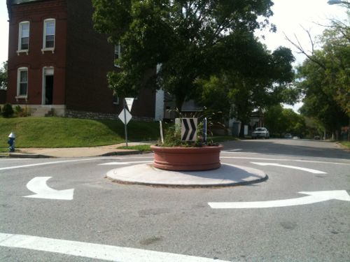
A traffic circle like the one at Louisiana & Osceola is an alternative
Traffic circles are commonly used in intersections in some other cities, I’m most familiar with the ones in Seattle. However, some say these are dangerous to cyclists. I think we need to look at our stop signs and determine if changes need to be made to reduce their use in some areas.
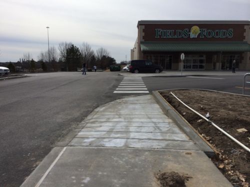
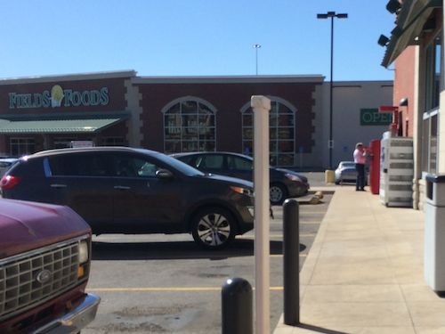
In December I showed a blatant ADA-violation at Fields Foods, no ramps where the pedestrian route crosses a driveway. Once we got a break in the weather they began busting out concrete to build it how they should’ve in the first place. A friend and I took the bus there on February 22nd, I was pleased:
You can see the mew ramp in the foreground
This ramp is also new, as is the crosswalk paint. Pedestrians entering from 14th or from the east still aren’t considered.
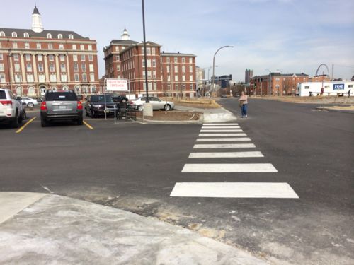
I’ve suggested ways to connect to the East once the last part of the site is developed, and I’ve suggested the route, above, be connected to 14th — assuming the 14th St entrance remains open. The other topic I raised was that of conducting multiple buildings within the same development.
The ADA also requires a pedestrian route between buildings within the same development, which wasn’t considered here at all.
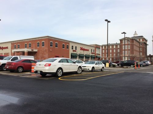
The other day we needed to get something from Walgreen’s & Fields Foods, I was able to see how easy it would be to connect these two. Of course, it would’ve been much easier if planned in advance.
We drove to Walgreen’s first. It was obvious connecting these two would be fairly simple by extending the Walgreen’s sidewalk until it reaches Fields Foods.
We then drove the short distance to Fields Foods. Looking back we can see the direct route or connecting to the existing ramp at Walgreen’s. Planned in advance, a sidewalk connecting these two would’ve been easy and been an asset to the development.
Some might say this would result in the loss of two spaces. I’d argue if planned right from the start no spaces would have been placed in the way. The drive aisles are wide, asphalt is everywhere. Poor site planning isn’t an excuse for violating the ADA. Given the proximity and lack of obstacles, it can’t be argued as not readily achievable.
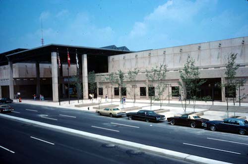
In the 1970s civic leaders were busy destroying large swaths of downtown in order to retain/attract workers/employers & residents. In 1977 the Cervantes Convention Center opened with largely blank exterior walls and occupying 4 formerly separate city blocks.
The following Spring, 36 years ago today, they continued in the same direction advocated by our first planner Harland Bartholomew decades earlier:
The St. Louis Board of Aldermen approved three bills that would set the stage to develop a proposed downtown shopping mall, with the only further step being the acquisition of federal funding. The headquarters of Stx, Baer, & Fuller, which would become Dillard’s just months before the mall’s completion, and Famous-Barr existed with one block separating them between Washington and Locust at 6th Street. The goal was to create an enclosed, urban shopping mall with these two companies as anchors, and the estimated budget was nearly $150 million. St. Louis Centre opened in 1985 as the largest shopping mall in America. It had over 150 stores and 20 restaurants, and was initially a great success. Challenges appeared in the 1990s however, as the Westroads Shopping Center was redeveloped into the St. Louis Galleria and stores began closing. St. Louis Centre closed in 2006, and since then has been redeveloped into a 750-car parking garage and retail center. (STL250 on Facebook)
Seven years later the internally-focused mall opened. The pedestrian realm in St. Louis was officially dead.
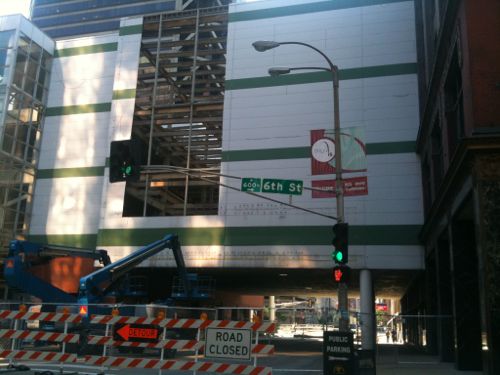
Looking west from 6th Street on May 22, 2010 as the pedestrian bridge over Washington Ave is being razed.
In the 1970s big indoor shopping malls were all the rage. We know now in an urban setting, like a central business district, turning blank exterior walls to the sidewalk and putting all retail activity indoors out of view to people passing by is a formula for disaster. In hindsight, it’s obvious. At the time few realized the magnitude of the mistake.
When the Cervantes Convention Center was expanded a block to the south in the early 1990s it was given a new more inviting facade, controversial at the time. St. Louis Centre was converted into a large parking garage in this decade, with retail spaces facing outward to the sidewalk. Slowly we’re relearning that a CBD can’t appeal to the suburban motorist. The urban core of any region should distinguish itself from the suburbs.
Suburbia can’t match old urban neighborhoods, usually failing when it tries. Conversely, older urban areas fail when trying to be like new suburbs. Most people chose suburbia, I get that. In the St. Louis region we have plenty of suburbia for those who prefer it, we need to double-down on making the City of St. Louis the pedestrian-froendly urban environment preferred by the rest of us. These can co-exist in the same region. Unfortunately, we’ve gotten to the point of having so little good urban area that those seeking an urban life have had no other choice but to leave the region.
A few urban block here and there won’t support an urban life, we need a city 100% committed to the urban dweller.
Please vote in the poll, located in the right sidebar
The St. Louis Treasurer’s Office is looking at new parking technology for the City of St. Louis to replace the coin-only individual meters. For the poll this week I want to get a sense of which type of physical payment machine readers prefer.
Individual meters
We’re all familiar with the individual meter, but in the 21st century they can now accept credit cards, but not bills. Paying via a mobile app means you don’t need to fiddle with the meter.
Pay-and-Display stations
With Pay-and-Display you park, walk to a station to buy your time, take the receipt back to your car and stick it inside the side window (it has a Post-It like substance to self adhere), the paid receipt is valid in the same zone until the time expires. With this option parking space length is not defined. Accepts coin, cash, credit cards. Paying via a mobile app means you don’t need to take a receipt back to your car.
Pay-Per-Space stations
Pay-Per-Space eliminates the need to return to your car. You park, note the 3-4 digit space number you’re parked in, walk to the station, enter the space number, pay for time, go to your destination. Paying via a mobile app means you can pay while looking at the space number.
Mobile apps work with all three types. In the poll this week I’ve included every combination of the above types, I’d like you to pick the answer that corresponds with the order you prefer them from 1-3, the poll is in the right sidebar.
AARP Livibility Index
The Livability Index scores neighborhoods and communities across the U.S. for the services and amenities that impact your life the most
Built St. Louis
historic architecture of St. Louis, Missouri – mourning the losses, celebrating the survivors.
Geo St. Louis
a guide to geospatial data about the City of St. Louis