Nineteen year ago I started this blog as a distraction from my father’s heart attack and slow recovery. It was late 2004 and social media & video streaming apps didn’t exist yet — or at least not widely available to the general public. Blogs were the newest means of …
The new NGA West campus , Jefferson & Cass, has been under construction for a few years now. Next NGA West is a large-scale construction project that will build a new facility for the National Geospatial-Intelligence Agency in St. Louis, Missouri.This $1.7B project is managed by the U.S. Army …
Book publisher Island Press always impresses me with thoughtful new books written by people working to solve current problems — the subjects are important ones for urbanists and policy makers to be familiar and actively discussing. These four books are presented in the order I received them. ‘Justice and …
This post is about two indirectly related topics: the new Siteman Cancer Center building under construction on the Washington University School of Medicine/BJC campus and an update on my stage 4 kidney cancer. Let’s deal with the latter first. You may have noticed I’ve not posted in three months, …
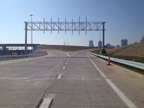
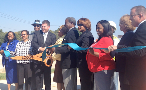
Yesterday MoDOT and city officials cut a ribbon to open traffic from I-70 onto the new Tucker.
An hour before the off ramp from I-70 to Tucker signs still weren’t placed. Only the right was opened, the left will be for I-70 traffic when the new bridge opens next year
The view of downtown motorists will now see
Officials cut the ribbon opening the off ramp from I-70 onto the new Tucker on September 26, 2013.
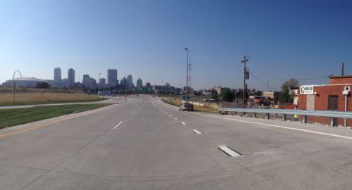
The land surrounding thus on/off ramp is now more valuable.
With the new offramp, and the opening of the Stan Musial Veterans Memorial Bridge in 2014, the adjacent land is suddenly prime real estate. Will it be developed like most highway offramp areas or will it be more urban/dense/walkable? I don’t have any illusions the city will make any such demands so my only hope is Paul McKee comes through with a plan the surprises his many critics.
Metro transit customers asked for newer technology to help them track MetroBus arrival times and now it is here. When Proposition A passed, Metro promised to use those funds to build a better transit experience. The first phase of technology advances to keep MetroBus customers better informed about bus stop arrivals is now available on www.metrostlouis.org.
“We are really excited to be able to bring this new technology to our customers, but we won’t stop there,” said Ray Friem, Metro Chief Operating Officer Transit. “In the next year, we hope to roll out the cell phone application. That will mean you can stand at your bus stop, punch in the stop number on your smart phone and find out when to expect your bus.”
Here’s how the new online technology works. Go to the Metro website, look for the Plan Your Trip area near the top right of the screen and select Metro Trip Planner. Then there are two choices. 1. Use the left side of the screen to use trip planner the way you always have, or 2. Use the map to click on your departure location. A box will appear and allow you to click on “Find nearby stops.” From there you can:
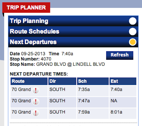
• Click on the yellow or blue circle where you want to catch the bus. Yellow circles show “time points.” Operators do not leave early from a time point. The blue circle shows a regular bus stop. Please remember to arrive at your stop at least five minutes early. Depending on traffic conditions, a bus may arrive and leave early from a bus stop that is not a time point. After you have selected your preferred stop: • Click on “Get next departures.” Included in the information box is the route, the direction (Dir), scheduled arrival time (Sch) and estimated arrival time (Est) if the estimated arrival time is available. • The majority of our MetroBus vehicles are now equipped with automatic vehicle location devices (AVL) and that allows us to track where the buses are at all times. Eventually, AVLs will be installed on every vehicle in our MetroBus fleet. If the MetroBus vehicle that is headed to your stop is AVL equipped, the Estimated Arrival column will show a time. When you compare Scheduled Time (Sch) to the Estimated time (Est) you will know if the bus is running early, on time or behind schedule. • If the MetroBus does not yet have AVL, then the Estimated Arrival column will display ‘NA’ for “not available.” Customers who need assistance planning their trips, may call 314-231-2345 in Missouri or 618-271-2345 in Illinois Monday through Friday from 7:30 a.m. to 4:30 p.m.
The site is easy to use at home/work on a computer, laptop, or tablet. No mobile optimized site or app yet.
Example of scheduled versus estimated times, click image for Metro’s Trip Planner
It is easiest to look up times based on a bus stop number, so I’ve made note of the stop numbers near me at 16th @ Olive:
Eastbound (South): #15146
Westbound (North): #2605
To go west on the #10 I want Metro’s northbound route. Sounds confusing but it makes sense when you look at the route map. I still need to look up a few others on Washington and on 14th.
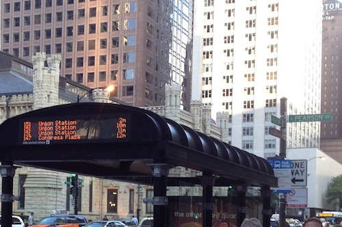
Eventually Metro will have the technology in place to show time until the next few buses, like this example from Chicago.
Once the information is available at shelters I’ll be really excited. I’m very glad Metro is making progress.
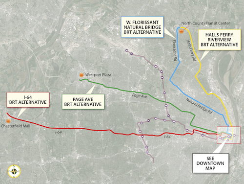
In the poll last week, readers preferred the proposed Bus Rapid Transit (BRT) route going out I-64 to Chesterfield. There was no clear preference among the other three options for a second choice to submit to federal authorities for a funding request. As I mentioned in my original post, here are the four routes being studied:
These four potential BRT routes are options for improving transit connections between St. Louis County and the City of St. Louis. One of the study’s main goals is to address the need for quick, direct travel from neighborhoods north and south of Downtown St. Louis to employers located in north and west St. Louis County. The “Central Corridor” stretching from Downtown St. Louis to the Central West End and Clayton still holds the region’s largest concentration of jobs, but the largest job growth is occurring in places like Chesterfield, Earth City, and St. Charles – areas easily accessible by highway, but currently not by public transit. The type of BRT service currently being studied is intended to expand access and improve travel time to those job opportunities – of particular importance to reverse commuters traveling to major job centers in suburban areas – while also providing a premium transit alternative for car commuters. The Rapid Transit Connector Study will identify candidates for Metro’s first two BRT routes; Metro will continue to work with the region to identify future BRT routes. Other transit options identified in Moving Transit Forward, such as expansions of the MetroLink System, are intended to meet other long-term goals such as strengthening neighborhoods and encouraging transit-oriented development. Alternatives analysis involves evaluating the performance of each alternative along parameters including ridership, expanded access to key destinations, travel time savings, and land use benefits. These technical outcomes will be combined with public input to identify the two potential projects most likely to meet project goals, benefit the region, and successfully compete for federal funding.
Four alternative BRT routes, click image to view larger version
Here are the results from last week’s poll:
Q: Which two of the four Bus Rapid Transit (BRT) routes would you like to see planners seek federal funding (pick 2)
I-64 Highway BRT 27 [31.03%]
None 17 [19.54%]
West Florissant-Natural Bridge BRT 16 [18.39%]
Page Avenue BRT 16 [18.39%]
Halls-Ferry Riverview BRT 8 [9.2%]
Unsure/no opinion 3 [3.45%]
I like the idea of a Bus Rapid Transit route to Chesterfield, but I wonder if terminating the route at Chesterfield Mall is best. At this moment there’s interest in the two new outlet malls in the Chesterfield valley, but it’s unclear to me if the valley or mall is a better terminus point. I’d like to know the logic behind this decision, likely because it would serve more people.
The Halls-Ferry Riverview route received half as many votes as the West Florissant-Natural Bridge & Page Ave routes. I like both of these routes, they both side through parts of St. Louis that could benefit from improved transit.
My guess is the I-64 & West Florissant-Natural Bridge & Page routes will be the two selected for submission for federal funding. Two routes would have a stop one block away, another 5 blocks away, and Halls-Ferry route 11 blocks east. I’m in a good place, but I want to make sure any investment in new infrastructure serves an accepting public. I know city residents will go to Chesterfield for work, but will Chesterfield residents take a bus, albeit a nice bus, into the city rather than drive? I certainly hope so!
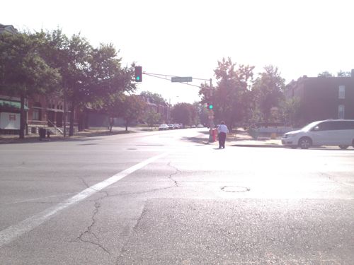
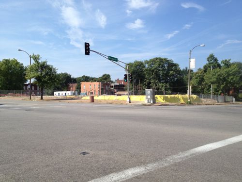
Jefferson Avenue is a 5+ mile north-south arterial road in south, central, and north St. Louis (map). Along this stretch the road has 4-6 travel lanes, a center turn lane, and sometimes 2 parking lanes. What’s pretty consistent is the public right-of-way and curb to curb widths are excessively wide.
A female pedestrian makes her way across Jefferson at Russell
Here are some examples of the right-of-way width in locations you might be familiar:
Jefferson @ Russell: 120 feet
Lindell @ Euclid: 100 feet
Kingshighway @ Delmar: 100 feet
Grand @ Hardford: 80 feet
Chouteau @ Mississippi: 80 feet
Manchester @ Taylor: 70 feet
The above figures are from Sanborn Maps, mostly from 1909. Again, these are the public right-of-way (PROW), which includes the road and sidewalks. In an urban context this is measured from the face of a building to the face of the building on the opposite side. The road & sidewalk widths can vary within the PROW.
At Russell, Jefferson has a wider PROW than streets like Grand, Lindell, and yes — Kingshighway! This partly explains why Jefferson doesn’t have the same “feel” as South Grand. The wider the curb to curb, the faster traffic travels. The faster the traffic, the fewer the pedestrians. Fewer pedestrians & faster traffic means businesses will focus on customers in cars, not pedestrians. This reality conflicts with adjacent neighborhoods that seek a more urban environment, like McKinley Heights whose code required Family Dollar to build more urban than usual.
Construction of the new SouthSide Early Childhood Center is underway on the SE corner
Jefferson passes by many neighborhoods and political wards, with different ones on the east & west sides. With schools & residents on both sides crossing the street is important. Some intersections have pedestrian signals, others, like Russell, do not. The east side is the McKinley Heights neighborhood & 7th Ward while the west side is the Fox Park neighborhood and the 6th ward, such fragmentation makes it challenging to get projects done.
Hopefully enough residents from both neighborhoods can convince Phyllis Young (7) and Christine Ingrassia (6) to take a closer look at Jefferson Ave.
I’d like to see the following in the short-term:
Stripe Jefferson to just 4 travel lanes end to end
Include a solid white outside line separating the right travel lane from the parking lane as MoDOT did on Gravois
Add pedestrian signals with countdown timers at existing signalized intersections currently lacking pedestrian signals
Stripe crosswalks in the more visible “Continental” pattern
In the longer term I’d like to see:
A detailed corridor study looking at all transportation modes (car, bike, transit, pedestrian), development patterns & potential, etc
A charrette to look at designing a new streetscape.
In the coming weeks & months I’ll post more about problems & solutions for Jefferson Ave.
Being an old city we have many old buildings that aren’t yet wheelchair accessible. When a business opens up they need to be aware of the ADA, especially when spending money remodeling.
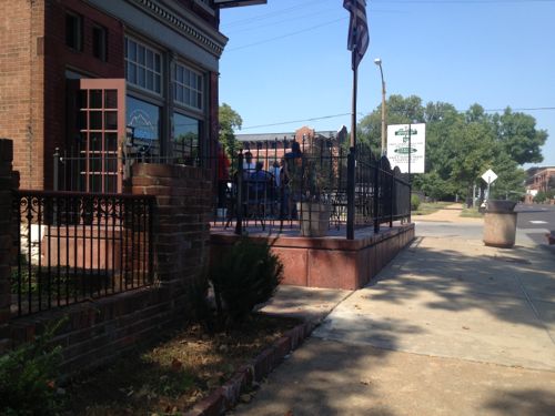
The building on the SW corner of Jefferson Ave & Winnebago St has had many establishments over the years, including quite a few since the 1990 passage of the ADA. Most changes over the years have been relatively minor. According to city records the previous owner owned the property from December 1977 to July 2007. In 2008 the current owner added a new patio out front, mostly in the public right-of-way. This was the perfect opportunity to make the first floor of this 1890 building wheelchair accessible.
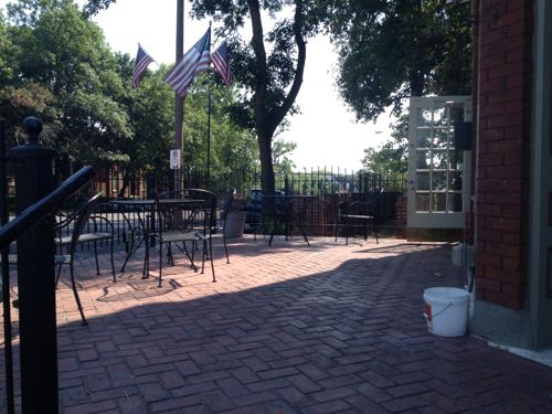
The 2008 patio at Jefferson Ave Bistro
Looks very nice!
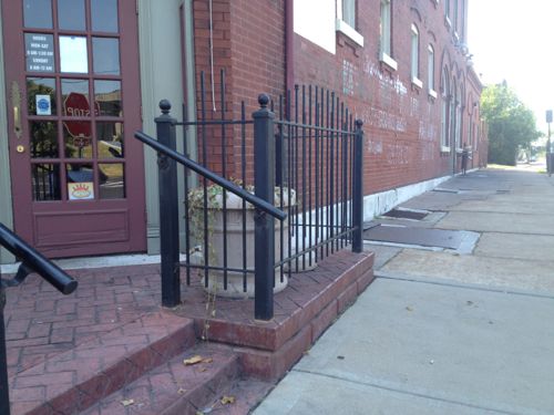
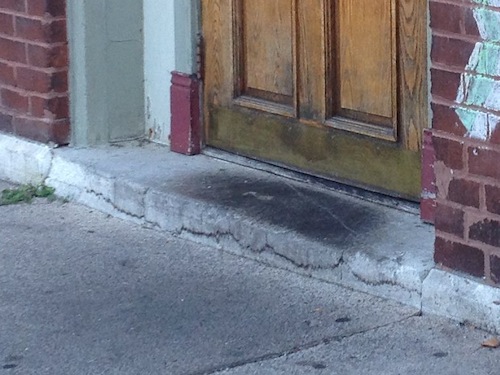
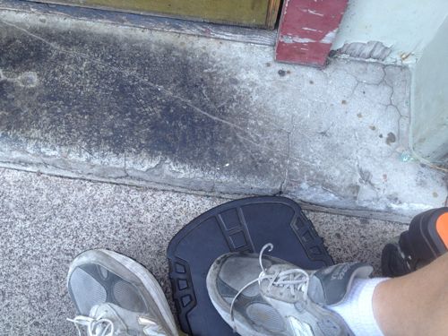
But it has steps up from the sidewalk, maybe the door on the side is the accessible entrance?
This door is unlocked and also used as an entrance, the step makes it impossible to enter
My footrest ran right into the step up
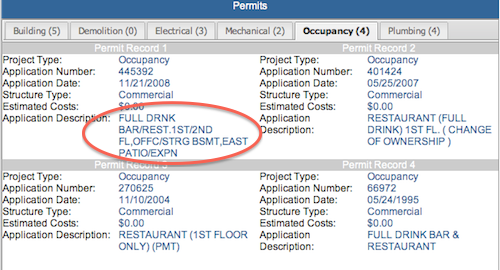
I didn’t find a building permit for the patio online, perhaps it was built without prior approval. This occupancy permit mentions patio expansion
When the patio was built the owner could’ve easily modified the sidewalk to provide access to the side door. It would’ve been a relatively minor add on to the patio project. To do it now will be far more costly.
AARP Livibility Index
The Livability Index scores neighborhoods and communities across the U.S. for the services and amenities that impact your life the most
Built St. Louis
historic architecture of St. Louis, Missouri – mourning the losses, celebrating the survivors.
Geo St. Louis
a guide to geospatial data about the City of St. Louis