Nineteen year ago I started this blog as a distraction from my father’s heart attack and slow recovery. It was late 2004 and social media & video streaming apps didn’t exist yet — or at least not widely available to the general public. Blogs were the newest means of …
The new NGA West campus , Jefferson & Cass, has been under construction for a few years now. Next NGA West is a large-scale construction project that will build a new facility for the National Geospatial-Intelligence Agency in St. Louis, Missouri.This $1.7B project is managed by the U.S. Army …
Book publisher Island Press always impresses me with thoughtful new books written by people working to solve current problems — the subjects are important ones for urbanists and policy makers to be familiar and actively discussing. These four books are presented in the order I received them. ‘Justice and …
This post is about two indirectly related topics: the new Siteman Cancer Center building under construction on the Washington University School of Medicine/BJC campus and an update on my stage 4 kidney cancer. Let’s deal with the latter first. You may have noticed I’ve not posted in three months, …
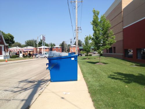
I’m a huge advocate of recycling. I also know making it easier will get more people to recycle. But that convenience shouldn’t come at the expense of walkability. Unfortunately that’s what happened in south St. Louis recently.
Trying to reach Chippewa along Clifton Ave behind Target I encountered a big blue obstacle blocking the sidewalk.
I had to go off into the grass to get around the bins. Not all wheelchairs/scooters are as capable. Someone walking with a cane or walker would have trouble walking on the grass.
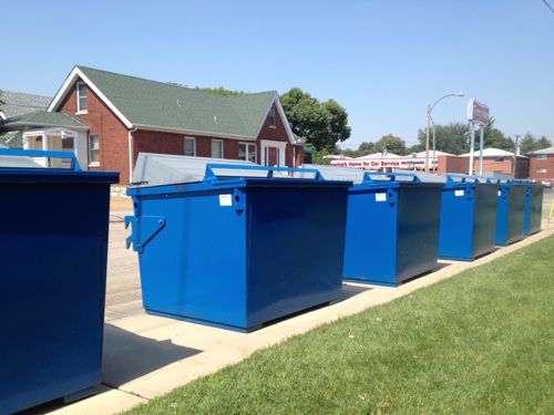
The six recycling bins, oriented to the street, viewed from across Clifton Ave
It wasn’t until this point in writing this post that I realized the dumpsters probably sit on the road most of the time, they likely got moved to the sidewalk while Clifton Ave was being resurfaced. I’m going to verify with city officials to ensure this was only temporary.
Recently I was critical of a proposed big box development along Forest Park Ave, adjacent to the main Saint Louis University campus. My issue isn’t with big box retail stores themselves, my issue is with how big box developments are typically laid out: massive surface parking lots, large blank walls facing public sidewalks, too few pedestrian connections to the outside & internally.
From page 12 of a 2010 Brookings report:
Considering the economic benefits, walkability should be a critical part of all strategic growth plans. The implications of this study cut across the federal and state, metropolitan, and place levels.
Public policy should become more favorable toward walkable placemaking. Currently, many federal and state subsidies substantially favor low-density development and tip the scales against walkable development. Further, many local zoning codes make walkable development illegal, necessitating costly and time-consuming zoning changes with no guarantee of success. Federal, state, and local policy makers should conduct a systematic review of existing public policies that are biased against walkable development, and adopt new measures aimed at facilitating (or at least removing roadblocks to) this type of development.
For their part, local and regional planning agencies should incorporate assessments of walkability into their strategic economic development plans. Planning entities should identify where regional- serving and local-serving walkable urban places exist within a metropolitan area, seek out those places that are positioned to become more walkable, and determine potential locations of future walkable places. This type of assessment will help determine where infrastructure and other built environment improvements are needed. Since high-density walkable urban places seem to account for a small amount of a metropolitan area’s existing land mass, it is probable that the infrastructure cost per dwelling unit or commercial square foot will be a fraction of that of existing low-density drivable suburban infrastructure costs.
At the same time, the apparent supply-demand mismatch for walkable places may be contributing significantly to the price premium these places demand. To the extent that this is the case, the short- and medium-term shortage of walkable places makes them inaccessible (unaffordable) to many people who desire to live in such places. As such, it is important to have an affordable housing strategy in place while those improvements are being implemented. (Walk this Way: The Economic Promise of Walkable Places in Metropolitan Washington, D.C. Christopher B. Leinberger and Mariela Alfonzo)
The proposed “Midtown Station” project would turn its back on both Vandeventer & Forest Park Avenues, which is only marginally acceptable pattern out in suburbia, but unacceptable in an urban context — especially adjacent to a major university.
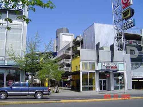
In searching for alternatives I remembered a project I visited about a decade ago and blogged about in 2005. This development has multiple big box stores including a 2-level Target, a Best Buy, a Sport’s Authority, and a Ross. Smaller size spaces front the sidewalk.
Urban big box development on Northgate in Seattle
A Quizno’s fronts onto the Northgate Way sidewalk
This project isn’t located in downtown Seattle either, it’s nearly 8 miles up I-5 (map). The main mode in this part of Seattle is private automobile, but thankfully newer development isn’t geared solely to motorists.
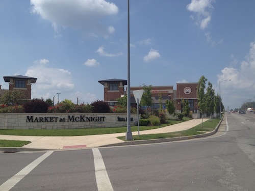
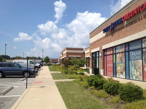
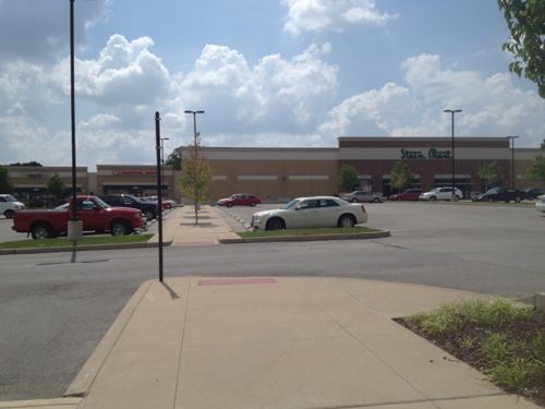
The best local example of rethinking big box development the Market at McKnight in Rock Hill, with a 36,000sf Stein Mart that opened in October 2007. Ok, not exactly a big box, but a big portion of the 130,000sf development.
The Market at McKnight project in Rock Hill is the best local example of providing a more pleasant front along the roadway with big box behind
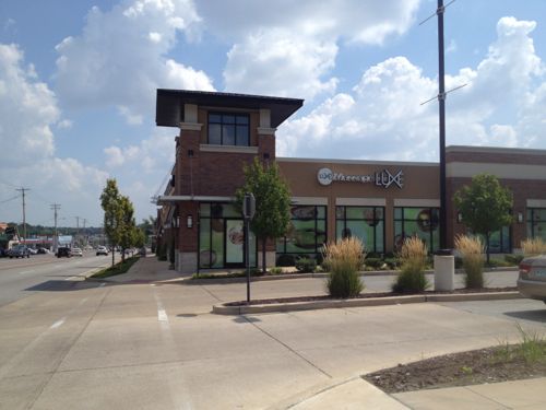
One story buildings along Manchester Rd give a more urban feel, windows give something for pedestrians to look into as they walk by
No business has a door onto the Manchester sidewalk, but it is pleasant as a pedestrian and motorists can see businesses as they drive by.
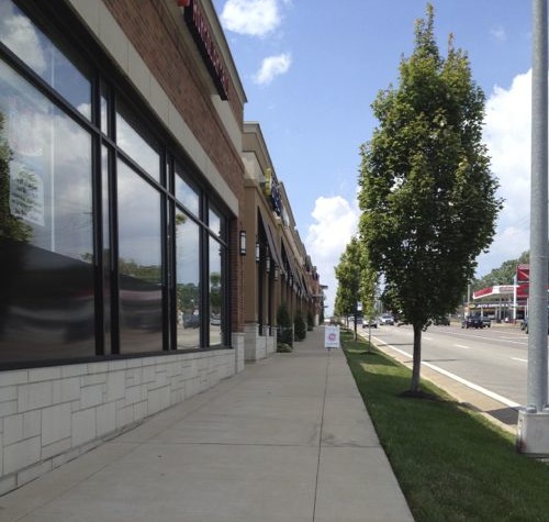
The businesses actually front the surface parking lot
Pedestrians have a clear path to reach the Stein Mart on the far side of the development.
My window view from The Original Mongolian Grill
The view isn’t great, but the point is there’s a relationship with the sidewalk & street. From inside I could see others going by and they could see me. Instead of creating something active along Forest Park Ave. Midtown Station wants to create something like this:
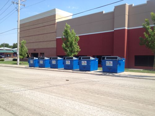
Back (Clifton Ave) side of the Hampton & Chippewa Target location.
Dreadful anywhere, but especially so close to a college campus and near public transit. Developers have shown there are alternatives to the standard big box project of the last 15-20 years.
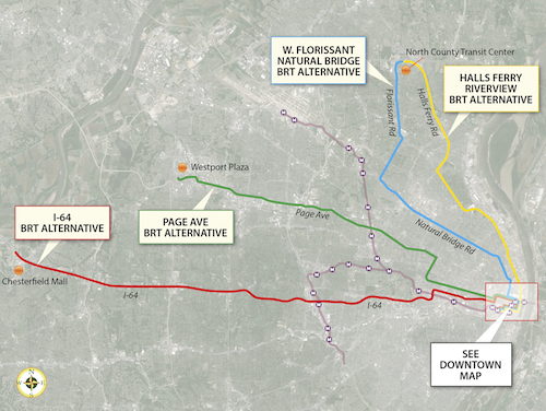
Last week regional transportation planners presented four Bus Rapid Transit (BRT) being considered. Soon two will be picked to submit for federal funding.
Four alternative BRT routes, click image to view larger version
I attended the presentation at City Hall and participated in the audience voting using hand held devices. They asked a couple of questions to help them in their decision. To keep things simple I’m just asking which two of the four BRT routes should move forward with a request for federal funding.
These four potential BRT routes are options for improving transit connections between St. Louis County and the City of St. Louis. One of the study’s main goals is to address the need for quick, direct travel from neighborhoods north and south of Downtown St. Louis to employers located in north and west St. Louis County. The “Central Corridor” stretching from Downtown St. Louis to the Central West End and Clayton still holds the region’s largest concentration of jobs, but the largest job growth is occurring in places like Chesterfield, Earth City, and St. Charles – areas easily accessible by highway, but currently not by public transit. The type of BRT service currently being studied is intended to expand access and improve travel time to those job opportunities – of particular importance to reverse commuters traveling to major job centers in suburban areas – while also providing a premium transit alternative for car commuters. The Rapid Transit Connector Study will identify candidates for Metro’s first two BRT routes; Metro will continue to work with the region to identify future BRT routes. Other transit options identified in Moving Transit Forward, such as expansions of the MetroLink System, are intended to meet other long-term goals such as strengthening neighborhoods and encouraging transit-oriented development. Alternatives analysis involves evaluating the performance of each alternative along parameters including ridership, expanded access to key destinations, travel time savings, and land use benefits. These technical outcomes will be combined with public input to identify the two potential projects most likely to meet project goals, benefit the region, and successfully compete for federal funding.
You may not like any of the four, however, I’ve not allowed any custom answers so you can’t suggest any other routes. These four need to be narrowed to two. I did provide “none” as an option as well as “unsure/no answer.” The poll is in the right sidebar (desktop layout).
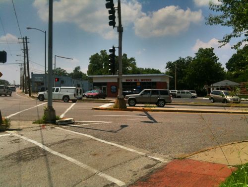
In the past few weeks I’ve gotten a couple of 20-somethings to ride the bus system here. Both had ridden MetroLink light rail, but not MetroBus.
The #11 (Chippewa) MetroBus on 14th St next to Peabody Opera House, 8:24pm
Here are some observations, in no particular order, about transit:
People who say they’d ride their local transit system if it didn’t suck have probably never ridden it enough (ever?) to understand how to use it. Dissing your local transit service is an accepted narrative.
Americans visit Europe and marvel at their efficient public transit and walkable cities, yet resume driving everywhere upon return.
A first time transit rider is more intimidated by bus than light rail/streetcar.
Related, people willingly try rail (light rail or streetcar), but not bus.
People compare bus vs car travel time, often concluding the bus takes too long. I say I can’t do enough email, social media, or casual reading while driving.
Transit naysayers are the same people who drive to the gym, circling the parking lot for a spot near the door.
These are my personal observations, they’re neither right or wrong.
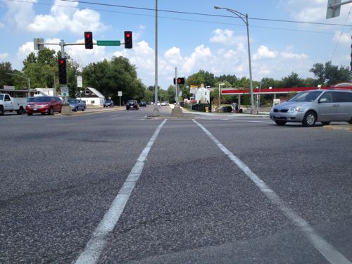
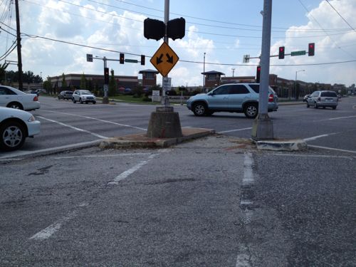
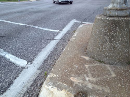
Recently I wanted to cross Manchester Rd, state highway 100, at McKnight. I quickly found out doing so is far from ideal in a wheelchair. On the surface it looks good: crosswalks, pedestrian signals, etc. Let me show you one glaring problem I discovered:
Looking north across Manchester at McKnight
Looking southwest from the NE corner of Manchester & McKnight
Close up of cut out for those crossing McKnight. Attractive, huh?
But those trying to cross Manchester are out of luck
Over the last 20+ years three out of the four corners at this intersection have been redeveloped, and Rock Hill has been trying nearly as long on the fourth. Why is this still an issue? Who cut out part? How long ago?
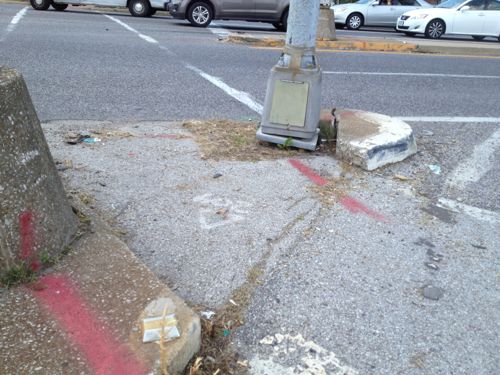
The cutout existed in 2011. I drove this day so I didn’t attempt to cross either McKnight or Manchester
Three possible culprits: Rock Hill, St. Louis County, or most likely, MoDOT. I suspect MoDOT because Manchester Road is Missouri State highway 100. I hope to find out why this wasn’t addresses recently when a gas station replaced the stone Rock Hill church on this corner.
This is part of the problem with having too many entities: municipal, county, & state.
AARP Livibility Index
The Livability Index scores neighborhoods and communities across the U.S. for the services and amenities that impact your life the most
Built St. Louis
historic architecture of St. Louis, Missouri – mourning the losses, celebrating the survivors.
Geo St. Louis
a guide to geospatial data about the City of St. Louis