Celebrating Blog’s 19th Anniversary


  Nineteen year ago I started this blog as a distraction from my father’s heart attack and slow recovery. It was late 2004 and social media & video streaming apps didn’t exist yet — or at least not widely available to the general public. Blogs were the newest means of …

Thoughts on NGA West’s Upcoming $10 Million Dollar Landscaping Project


  The new NGA West campus , Jefferson & Cass, has been under construction for a few years now. Next NGA West is a large-scale construction project that will build a new facility for the National Geospatial-Intelligence Agency in St. Louis, Missouri.This $1.7B project is managed by the U.S. Army …

Four Recent Books From Island Press


  Book publisher Island Press always impresses me with thoughtful new books written by people working to solve current problems — the subjects are important ones for urbanists and policy makers to be familiar and actively discussing. These four books are presented in the order I received them. ‘Justice and …

New Siteman Cancer Center, Update on my Cancer


  This post is about two indirectly related topics: the new Siteman Cancer Center building under construction on the Washington University School of Medicine/BJC campus and an update on my stage 4 kidney cancer. Let’s deal with the latter first. You may have noticed I’ve not posted in three months, …

Recent Articles:

5th Ward Special Election Today


Today voters in the 5th ward will go to the polls to select one of three candidates to finish the term of former alderman April Ford-Griffin who resigned to take a city position.

ABOVE (L-R): Candidate forum moderator Kathleen Farrell, candidate Tonya Finley and Rose M. Green

Independent candidates Tonya Finley and Rose M. Green participated in the candidate forum last week. The Democratic nominee Tammika Hubbard confirmed two days prior but she didn’t participate. I expected to meet and hear from all three candidates. The volunteers from the League of Women Voters of St. Louis did an outstanding job with the two candidates  that took the time to show up.

I voted absentee last week, access to my new polling place via public transit would require me to cross 14th Street without a signalized crosswalk — too dangerous.

ABOVE: Ballot on electronic voting machine (click image to view official ballot)

Turnout will be low for this election, very few people deciding who completes the term that ends in April 2013. This may cause me problems down the road for disclosing this but I voted for Tonya Finley in this election.

– Steve Patterson

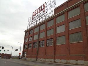
Urbanists & Preservationists Will Support Pevely Dairy Today


ABOVE: The historic Pevely Dairy maintains the building line at both Grand & Chouteau. Click image for my post from last month

The Preservation Board usually meets on the 4th Monday of each month but due to the holidays will instead meet tonight. On the agenda is Saint Louis University’s proposal to replace the historic structures with a lawn. And probably a fountain.

The conclusion of the staff report (see agenda):

The proposed subsequent construction of the Ambulatory Care Center cannot be evaluated at the time these comments were prepared and needs to be considered once presented at the Preservation Board meeting. The Cultural Resources Office recommends that the Preservation Board approve the demolition of the milk plant at 3626‐80 Chouteau and the garage at 1101 Motard, as the loss of these Merit buildings would have an acceptable effect on the urban design and the streetscape. The Cultural Resources Office also recommends that the Preservation Board uphold the denial of the demolition of the office building as it is a sound, High Merit resource and has reuse potential, and the iconic smokestack. These two structures on the parcel with the address 1001‐03 S. Grand, are prominent in the streetscape and their loss would have a noticeable effect on the physical fabric of the neighborhood and urban design.

Many have expressed the viewpoint the corner structure and smokestack occupy a tiny portion of the total site and therefor do not impede plans for new construction on the rest of the site. I’d love to see a drawing with Saint Louis University’s proposed building superimposed over the corner structure and smokestack.

– Steve Patterson

Poll: How Prepared Are You For a Catastrophe?

December 18, 2011 Sunday Poll 6 Comments
 

Friday was the two-hundred year anniversary of the New Madrid earthquake and many think another is due. Missouri experienced devastating tornados and flooding in 2011. Writing the post for last friday (New Madrid Earthquake Two Centuries Ago) I realized I’m not prepared for a catastrophe.

Did you know only 2 in every 10 Americans feel prepared for a major disaster? Emergencies and disasters can strike quickly and without warning. The best way to make your families, employees and homes safer is to be prepared before disaster strikes. The Red Cross is here to help your group get prepared.

The St. Louis Area Chapter offers emergency preparedness education programs for people of all ages. Each year, tens of thousands of St. Louis area residents take part in these presentations at schools, businesses and community events.

It is the Red Cross’ mission to help the community prevent, prepare for and respond to disasters. A disaster can strike at any moment, the Red Cross wants to show you and your family how to be ready. (St. Louis Red Cross)

The poll question this week asks how prepared you are for a catastrophe.

– Steve Patterson

Images of Crunden-Martin Manufacturing Co.

December 17, 2011 Downtown, Featured 4 Comments
 

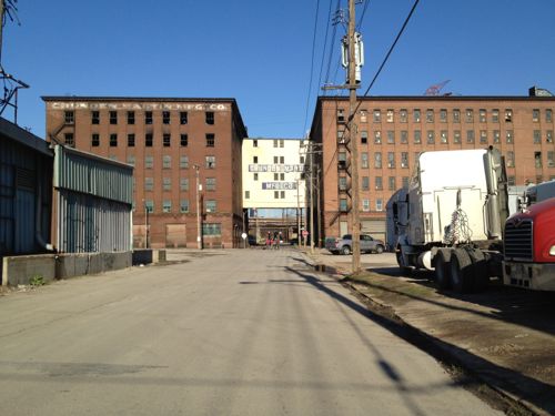
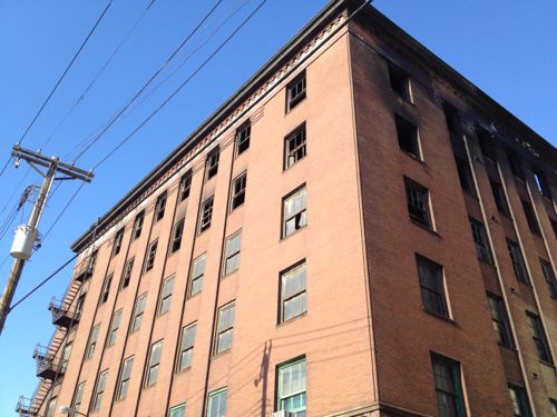
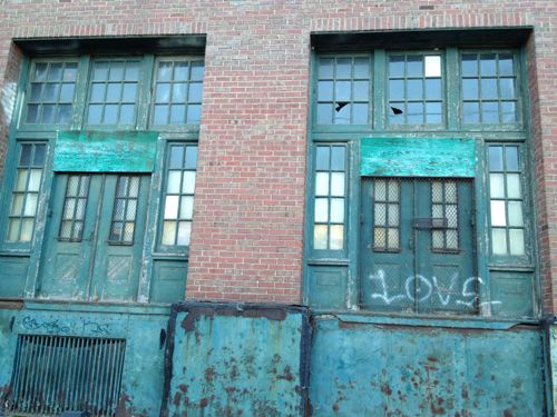
Last weekend I drove through Chouteau’s Landing to check out the fire damage to one of the seven Crunden-Martin buildings. I was surprised it didn’t look worse.

ABOVE: The brick building on the left had a 5-alarm fire on December 11th, looking north on 2nd St

ABOVE: The brick structure looks good, but the roof is now gone

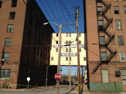
ABOVE: The fire didn't spread to the frame bridge

ABOVE: Doorways of another Crunden-Martin building

The collection of seven buildings is stunning. The railroad lines and other buildings in the area are a clue to the industrial strength the area had at the start of the 20th century.

– Steve Patterson

New Madrid Earthquake Two Centuries Ago


Two hundred years ago today the first of a series of three earthquakes hit near the Missouri town of New Madrid:

This sequence of three very large earthquakes is usually referred to as the New Madrid earthquakes, after the Missouri town that was the largest settlement on the Mississippi River between St. Louis, Missouri and Natchez, Mississippi. On the basis of the large area of damage (600,000 square kilometers), the widespread area of perceptibility (5,000,000 square kilometers), and the complex physiographic changes that occurred, the New Madrid earthquakes of 1811-1812 rank as some of the largest in the United States since its settlement by Europeans. They were by far the largest east of the Rocky Mountains in the U.S. and Canada. The area of strong shaking associated with these shocks is two to three times as large as that of the 1964 Alaska earthquake and 10 times as large as that of the 1906 San Francisco earthquake. Because there were no seismographs in North America at that time, and very few people in the New Madrid region, the estimated magnitudes of this series of earthquakes vary considerably and depend on modern researchers’ interpretations of journals, newspaper reports, and other accounts of the ground shaking and damage. The magnitudes of the three principal earthquakes of 1811-1812 described below are the preferred values taken from research involved with producing the 2008 USGS National Seismic Hazard Map .

The first principal earthquake, M7.7, occurred at about 2:15 am (local time) in northeast Arkansas on December 16, 1811. The second principal shock, M7.5, occurred in Missouri on January 23, 1812, and the third, M7.7, on February 7, 1812, along the Reelfoot fault in Missouri and Tennessee. The earthquake ground shaking was not limited to these principal main shocks, as there is evidence for a fairly robust aftershock sequence. The first and largest aftershock occurred on December 16, 1811 at about 7:15 am. At least three other large aftershocks are inferred from historical accounts on December 16 and 17. These three events are believed to range between M6.0 and 6.5 in size and to be located in Arkansas and Missouri. This would make a total of seven earthquakes of magnitude M6.0-7.7 occurring in the period December 16, 1811 through February 7, 1812. In total, Otto Nuttli reported more than 200 moderate to large aftershocks in the New Madrid region between December 16, 1811, and March 15, 1812: ten of these were greater than about 6.0; about one hundred were between M5.0 and 5.9; and eighty-nine were in the magnitude 4 range. Nuttli also noted that about eighteen hundred earthquakes of about M3.0 to 4.0 during the same period. 

The first earthquake of December 16, 1811 caused only slight damage to man-made structures, mainly because of the sparse population in the epicentral area. The extent of the area that experienced damaging earth motion, which produced Modified Mercalli Intensity greater than or equal to VII, is estimated to be 600,000 square kilometers. However, shaking strong enough to alarm the general population (intensity greater than or equal to V) occurred over an area of 2.5 million square kilometers.

The earthquakes caused the ground to rise and fall – bending the trees until their branches intertwined and opening deep cracks in the ground. Deep seated landslides occurred along the steeper bluffs and hillslides; large areas of land were uplifted permanently; and still larger areas sank and were covered with water that erupted through fissures or craterlets. Huge waves on the Mississippi River overwhelmed many boats and washed others high onto the shore. High banks caved and collapsed into the river; sand bars and points of islands gave way; whole islands disappeared. Surface fault rupturing from these earthquakes has not been detected and was not reported, however. The region most seriously affected was characterized by raised or sunken lands, fissures, sinks, sand blows, and large landslides that covered an area of 78,000 – 129,000 square kilometers, extending from Cairo, Illinois, to Memphis, Tennessee, and from Crowley’s Ridge in northeastern Arkansas to Chickasaw Bluffs, Tennessee. Only one life was lost in falling buildings at New Madrid, but chimneys were toppled and log cabins were thrown down as far distant as Cincinnati, Ohio, St. Louis, Missouri, and in many places in Kentucky, Missouri, and Tennessee.

The Lake County uplift, about 50 kilometers long and 23 kilometers wide, stands above the surrounding Mississippi River Valley by as much as 10 meters in parts of southwest Kentucky, southeast Missouri, and northwest Tennessee. The uplift apparently resulted from vertical movement along several, ancient, subsurface faults. Most of the uplift occurred during prehistoric earthquakes. A strong correlation exists between modern seismicity and the uplift, indicating that stresses that produced the uplift may still exist today. (USGS)

Many have been saying for years a big one is coming again.

ABOVE: Earthquake strengthening under I-64/Hwy 40, click image for more info

MoDOT began strengthening the double-deck portion of I-64/Hwy 40 in August 2006 and the work continues. Will we have the big one? I don’t know, my family & friends in Oklahoma didn’t think they’d feel an earthquake there but they did last month. I probably should put together an earthquake preparedness kit.

– Steve Patterson

Advertisement


[custom-facebook-feed]

Archives

Categories

Advertisement


Subscribe