Celebrating Blog’s 19th Anniversary


  Nineteen year ago I started this blog as a distraction from my father’s heart attack and slow recovery. It was late 2004 and social media & video streaming apps didn’t exist yet — or at least not widely available to the general public. Blogs were the newest means of …

Thoughts on NGA West’s Upcoming $10 Million Dollar Landscaping Project


  The new NGA West campus , Jefferson & Cass, has been under construction for a few years now. Next NGA West is a large-scale construction project that will build a new facility for the National Geospatial-Intelligence Agency in St. Louis, Missouri.This $1.7B project is managed by the U.S. Army …

Four Recent Books From Island Press


  Book publisher Island Press always impresses me with thoughtful new books written by people working to solve current problems — the subjects are important ones for urbanists and policy makers to be familiar and actively discussing. These four books are presented in the order I received them. ‘Justice and …

New Siteman Cancer Center, Update on my Cancer


  This post is about two indirectly related topics: the new Siteman Cancer Center building under construction on the Washington University School of Medicine/BJC campus and an update on my stage 4 kidney cancer. Let’s deal with the latter first. You may have noticed I’ve not posted in three months, …

Recent Articles:

Changes to the St. Louis Board of Aldermen in my lifetime, future change proposed


ABOVE: 1967 St. Louis ward map
ABOVE: 1967 St. Louis ward map. Source: We Elect! book from the Buckowitz archives

Every ten years, following each national census, the boundaries of St. Louis’ 28 wards are redrawn. The map above is based on the 1960 census.   UPDATE 2/8/2010 4:25PM:  the map above reflects changes following a 1965 lawsuit that challenged the way the maps were drawn. Prior to 1965 districts were based on the number of registered voters, not the number of residents.

The map below (rotated 90 degrees counter-clockwise) is the current map based on the 2000 census.

ABOVE: Current ward map

Most wards are still in the approximate same location while a handful are in completely different parts of the city.  The idea is for each ward to contain the same number of residents.  Areas that lose more people than others will see the physical size of the ward grow.

The ward map at the top is from a 1967 book published by the St. Louis Public schools explaining the election process: We Elect! The story of St. Louis Government and Politics.  It was published in the year I was born, 1967.  They met at 11am on Fridays wheres they meet at 10am Fridays currently, not sure when that changed.  Looking through the information in the book I decided I needed to put it in a table to see it in one place.

Some interesting things jump out at me:

  • Five new members were elected in 1967, three of which were Republicans (ward # shown in red).  One Republican is on the current board, first elected way back in 1979.
  • Eight members (29%) were Black.  Currently the board has 12 black members (43%) plus Board President Lewis Reed.
  • Only two female members (7%), both Black.  The current board has eight females (29%) split evenly between Black & White.
  • 32% (9/28) of the members had served 12 or more years.   Today 46% (13/28) have served 12 or more years.
  • Only one (4%) had served 20 years.  Today seven (25%) have served 20 or more years.
  • The average length of service was 7.5 years in 1967.  In 2010 it is 11.45 years, a 53% increase!

Elsewhere in the book the committeeman & committeewomen were listed for each ward. Every ward (except the 21st) had both Democrats & Republicans in place. We had somewhat of a two-party city in 1967.  Today we have a one party city yet we hold primary & general elections.  In one party elections holding a primary & general elections is just a huge waste of limited money.   With service cuts to reduce the city budget holding unnecessary partisan primaries is a luxury we just can’t afford.   I’d like a lawyer out there to contact me to see what it would take to switch our city elections to non-partisan.  I’d love a measure on the ballot during an an upcoming election, such as November 2010.

I know many of you are not fans of term limits but I see a need for a limit of say five terms/20 years.  Two decades is plenty of time to get into office, learn the ropes, and have an impact before passing the torch onto the next generation.

I will be on KDHX (88.1FM) tonight (Monday 2/8/2010) at 8:30pm discussing this and other local issues.

– Steve Patterson

Poll: Do you give money to the homeless on the street?


“Do you have any change?” Most of us have been approached by a homeless person asking for money.

ABOVE: entrance to the Horizon Club, a downtown St. Louis safe haven.

The poll this week asks how you respond when asked for money.  Next week when I present the poll results I’ll have some expert views on the subject.  In the meantime please vote and share your thoughts below.

– Steve Patterson

New exhibit focuses on the St. Louis riverfront that was razed in the 1940s

February 6, 2010 Downtown, Events/Meetings 5 Comments
 

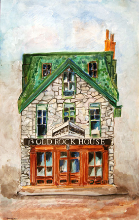
ABOVE: One of the 40 new paintings by Shelia Harris for this exhibit

The City of St. Louis had already cleared 40 city blocks of the riverfront before the competition was held that resulted in Eero Saarinen’s Arch. The city’s oldest buildings and street grid were lost in the process. All that remains are old photos, maps, drawings and the Old Cathedral.  Tomorrow the National Park Service opens a new exhibit focusing on what was lost:

“(St. Louis, MO)- Jefferson National Expansion Memorial will host a special exhibit from St. Louis artist Sheila Harris at the Old Courthouse from Feb. 14 through Aug. 22, 2010. Created especially for the memorial, the exhibit consists of nearly 40 watercolor paintings of buildings that once stood on the Arch grounds. The exhibit will launch with an artisit’s reception on Sunday, Feb. 14, at 2 p.m.

While the exhibit is on display at the Old Courthouse, Harris will discuss and demonstrate her technique during several scheduleded appearances. A schedule of the appearances can be found online at www.nps.gov/jeff.

For further information on the exhibit click here (PDF).”

Photos and maps will also be on display. Anyone who loves St. Louis’ history should see this exhibit.

– Steve Patterson

Project destroyed by 2006 arson fire getting rebuilt

February 5, 2010 Neighborhoods, South City Comments Off on Project destroyed by 2006 arson fire getting rebuilt
 

ABOVE:
ABOVE: morning of June 14, 2006

A few years ago St. Louis experienced some high profile arson fires. In April 2006 a condo project under construction on South Grand was totally destroyed.  Then in June 2006 two separate projects in Lafayette Square were torched.  A year later, to the day, an arsonist destroyed an apartment complex under construction.  All but one were rebuilt, finished and have been occupied for a while.

ABOVE: destroyed building finally being replaced.

The other day I noticed the last of the damaged buildings going up on Mississippi Ave. .  It is nice to see this hole facing Lafayette Park get filled in.

– Steve Patterson

What the passage of Proposition “A” can mean for the St. Louis region


ABOVE: St. Louis County Executive Charlie A Dooley
ABOVE: St. Louis County Executive Charlie "A" Dooley, August 2006

Tuesday April 6, 2010 voters in St. Louis County will decide the fate of Proposition A — a 1/2 cent sales tax to match the same tax previously approved by voters in the City of St. Louis.  Revenues would be used to fund existing operations and expand service of our regional public transit.

I decided to put together list of what “A” can do for the region:

  1. Accelerate: strong transit will accelerate the trend toward filling in the core rather than pushing outward at the edges.  This helps ensure those folks who moved to the edge won’t be surrounded by new construction.
  2. Accessible: public transit makes going from home to work accessible to many.  This applies to those of us with disabilities as well as those without access to an automobile. Getting our citizens to work, school is important for a strong region.
  3. Accomplish: dedicated funding is critical to a healthy  transit transit system.  Prop. A will accomplish the goal of creating a dedicated funding source for operations.
  4. Achieve: St. Louis will be closer to achieving the type of transit system a strong region needs to have to compete in the 21st century.
  5. Activate: transit helps create activity.  Transit riders are often pedestrians on part of their total trip.  Their activity creates a buzz around stations & stops.  More transit and more riders that will activate our sidewalks.
  6. Adjust: we will adjust our ideas about transit and what it means to the region, even if we don’t use the system ourselves (or just rarely).
  7. Affirm: passage will affirm our commitment to a regional transit network.  This affirmation will send a strong message to companies and people considering the St. Louis region as a future location.
  8. Affordable: as we saw when service was cut back people couldn’t get to work.  Employers need their employees at work.  Our region can’t afford to not have a functioning transit system.  We can’t afford to not pass this tax.
  9. Attainable: with dedicated funding Metro can attain a decent level of service for the region through both rail & bus transit.
  10. Augment: we will be able to augment the current system to better serve the core of the region, including St. Louis County.

For more information the on Proposition A see the Yes on A website at moremetrolink.com.

– Steve Patterson

Advertisement


[custom-facebook-feed]

Archives

Categories

Advertisement


Subscribe