Nineteen year ago I started this blog as a distraction from my father’s heart attack and slow recovery. It was late 2004 and social media & video streaming apps didn’t exist yet — or at least not widely available to the general public. Blogs were the newest means of …
The new NGA West campus , Jefferson & Cass, has been under construction for a few years now. Next NGA West is a large-scale construction project that will build a new facility for the National Geospatial-Intelligence Agency in St. Louis, Missouri.This $1.7B project is managed by the U.S. Army …
Book publisher Island Press always impresses me with thoughtful new books written by people working to solve current problems — the subjects are important ones for urbanists and policy makers to be familiar and actively discussing. These four books are presented in the order I received them. ‘Justice and …
This post is about two indirectly related topics: the new Siteman Cancer Center building under construction on the Washington University School of Medicine/BJC campus and an update on my stage 4 kidney cancer. Let’s deal with the latter first. You may have noticed I’ve not posted in three months, …
December 19, 2008DowntownComments Off on UrbanReviewSTL on Twitter & Facebook
Social Networking & mini-blogging are not new. I’ve been on Facebook since starting grad school way back in the Fall of 2006 (seems like so long ago). At that time Facebook was only open to college students. Since then it has been opened to everyone and it has grown rapidly.
To stay on top of new trends, I’ve created the Fans of UrbanReviewSTL group on Facebook. This is an open group that any Facebook member can join. In only a few days the membership in this group has grown to over 80 persons. Members can post photos of issues for me to write about and I’ll post links to interesting articles and other tid bits from time to time.
Twitter is all about micro-blogging. “Tweets” are limited to 140 characters. On Twitter I post info about new posts to be found here, meetings I’m attending and so on. I’ve got 30+ followers before this posting. So if you are on Twitter and want to follow me I’m @urbanreviewstl.
My iPhone, which I’ve had for nearly a year, helps me stay in contact and update both my Facebook & Twitter accounts on the go.
Since at least the 1930s the planners and traffic engineers that successfully destroyed much of St Louis in the name of progress have envisioned yet another highway in downtown St Louis. It was known as the 22nd Street Parkway and it was to connect hwy 40 on the South and I-70 on the North. The only part that got built was the connection to I-64/Hwy 40.
Thankfully none of the rest got built and the plans to build it have been scrapped.
For a while now MoDOT has been looking at simplifying the interchange to reduce the amount of land consumed — freeing up land to be redeveloped (see MoDOT’s page the interchange). The problem has been a lack of priority in funding the project of reclaiming this wasteland.
The interchange and much around it are the driver’s paradise and the pedestrian’s hell:
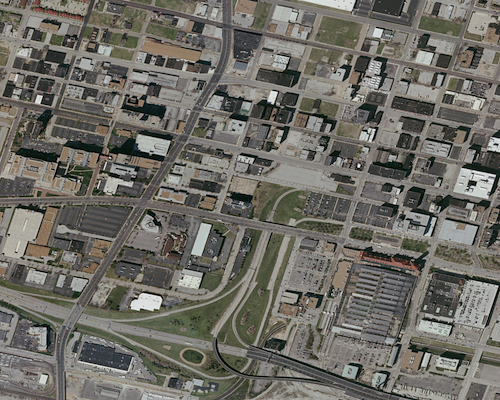
2006 Aerial showing Union Station in the lower right corner and the wasted space of the 22nd Street Interchange to the left of Union Station.
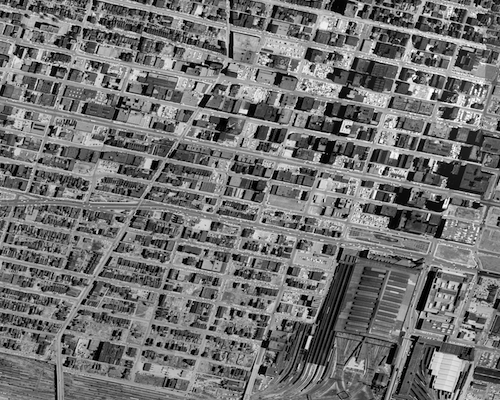
A half century ago the area looked and functioned quite differently:
1958 aerial image of exact same area as shown above.
Both images were purchased from Historic Aerials. To see larger images click either one to view them in Flikr where you can select a larger size.
We need to use this as a model for the future — not to replicate the buildings, but the finely woven street grid.
The 22nd Street Interchange, part of an abandoned highway concept from a few decades ago, needs to be ripped out with the land returned to active tax-paying use. The Missouri Dept of Transportation (MoDOT) should rework the interchange at Jefferson Ave to allow for on/off ramps in both directions and therefore eliminating the need for the current ramps at 22nd. MoDot could sell the land to fund the revisions to the highway ramps.
I picture a new bridge at I-64/40 and Jefferson Ave — one with a single point urban interchange (SPUI) and both East & West on/off ramps. Build that and then remove the 22nd interchange completely. Bring in form-based zoning codes to require a denser urban environment. Make a strong connection through the back of Union Station (between the shed & highway) so that pedestrians from this newly developable land have the opportunity to walk to Metrolink and the 14th street transit station beyond that. The fact that much of this area is already excavated and free of utility lines would simplify the construction of underground parking in new buildings.
If Missouri is asking the new Obama administration to help fund infrastructure this should be near the top of the list. I’m going to suggest that Ald Kacie Triplett (D-6th Ward) put this on the front burner as a way to kickstart the redevelopment of this area.
Such a project could be a huge boon for the city. The impact would certainly be felt beyond the immediate area. For example, Chestnut & Pine could both be returned to two-way traffic. Union Station could once again have an adjacent neighborhood.
A downtown streetcar circulator loop could connect this new neighborhood to the other parts of downtown. With such a large open area it would be the perfect spot for an urban Target store — picture the Hampton & Chippewa store (underground parking) except without the surface parking out front. Retailers that would prefer new construction over squeezing in a historic building would love the location. Building heights of 3-5 floors would give a nice scale although I would not propose any maximum.
St Louis has much rebuilding to do. We’ve got to roll up our collective sleeves and get busy. The current economic situation will improve in a few years and when it does we need to have the new streets in the works and the zoning in place.
Zoning has been one of the most destructive forces in cities. It’s good intentions have been taken too far and as a result it is nearly impossible to do good urban design in most places in North America. Between density restrictions and excessive parking minimums the resulting pattern will be the non-walkable sprawl we have all around us.
One of the solutions, of course, is to trash current zoning in favor of something more reflective of today’s thinking (vs. yesterday’s thinking). Such a task is a huge undertaking. A compromise is to ease into it with an “overlay” in specific areas. An overlay district would superseed all existing zoning — thus replacing it for a defined area. Often these are used around transit stations to get the sort of density, diversity of users, and walkability that is desired at transit stops.
The City of Clayton’s Plan Commission Architectural Review Board recently recommended to the Clayton Board of Alderman to adopt two Transit Oriented Development (TOD) Overlay districts for the areas surrounding the Central Avenue and Forsyth Metrolink Stations. The new overlay codes in essence frees up the market to take advantage of MetroLink by encouraging mid to high density residential and mixed-use development surrounding each station.
A transit oriented development is a high density, mixed use area located within walking distance of a transit station. These areas are unique in that they maximize access to a mass transit station, encourage higher density, and de-emphasize the use of a car as the primary mode of transport.
This is exciting news. From the staff memo to the Clayton Planning Commission:
Key components of the draft Transit Oriented Development Districts include:
Encourage higher density development by establishing minimum Floor Area Ratios and waiving FAR’s altogether depending on the location.
Waives minimum off-street parking requirements based on a professional parking study clearly demonstrating need levels.
Provides relief of height restrictions while requiring building step-backs in some areas.
Establishes minimum front yard setbacks to encourage greater sidewalk widths.
Limits automobile-type land uses such as service station and automobile agencies.
Establishes site plan considerations to foster innovative site design such as green building certification, linkages between the development and the transit station, and greenspace/urban gathering areas.
The Clayton Business District Master Plan (1993) recognized the need to consider mass transit as a key component to redevelopment opportunities. MetroLink and its potential for influencing development are specified in four action areas (4, 5, 13, & 14) adjacent to the stations. In these action areas, the Business Districts Master Plan points to the need to consider MetroLink as one of the factors that may positively influence economic performance of the property and its use and design.
Read the discussion on the Urban St Louis forum here. You can download and review the actual articles for the Forsyth & Clayton stations. Now if I can only get some folks at City Hall to wake up and realize the need for such zoning in spots throughout the city.
I spent a good portion of Saturday with the grand kids. No, not mine, a friend’s. But that required a trip to St Charles County. I’m not fond of driving West of Kingshighway so you have to appreciate how adorable these kids are to get me out there.
This sidewalk in St Charles bypasses the Walgreen's
Coming back to their house after lunch I snapped the above picture. Many places don’t even have sidewalks and those that do, like the above example, just line the road and don’t actually connect to anything. We passed a Wal-Mart (how predictable, right?) and I was pleasantly shocked to see the sidewalk connecting to the entrance – a proper ADA access route.
But for the most part the sidewalks just seem like decoration. Something to give the illusion you could walk to a store. But it is just that, an illusion of walkable. As bad as newer development in the city is, St Charles is far worse.
I grew up in a 1960s area of Oklahoma City that is just as bad. My parents moved there for the same reason people moved to St Charles, schools. Except where I grew up I was in the same district as the inner city but on the edge in newer buildings. We had no sidewalks. You only walked when the car broke down. Why else would you walk?
Don’t worry, the grand kids are getting exposed to urban life where you walk to places. Where you run into friends on the sidewalks rather than the mall parking lot.
Much like religion, I think it is good to expose youngsters to different perspectives and allow them to draw their own conclusions when they get older.  Just like many kids of the 50s picked the suburbs, todays kids will pick the core when they make their own living choices. If I’m wrong let me know in 2030.
In the meantime if we go to the trouble to have sidewalks wouldn’t it be a good idea it they actually connected to places?
Going to class at Saint Louis University last Thursday I noticed an interesting gap in the on-street parking in front of the building on Laclede.
Gap in on-street parking on Laclede West of Spring
I’m standing at my car looking at what is now known as the “Laclede Classroom Building.” This is a big gap in the on-street parking — enough for one or two cars. By not having parking here the city is losing money. “But that driveway!” you observe. Oh yes, the driveway.
As the above image shows, the driveway has been abandoned by the new owner, SLU. There is not even a service gate in the fence. There is no reason anymore to prevent someone from parking on-street here.
These examples exist all over the city — circumstances change but management of on-street parking doesn’t seem to change. I can think of several examples downtown where parking is not alowed at closed former drives. We need some system of alerting the parking folks in the Treasurer’s office when a substantial permit is issued for a building. This would prod them to evaluate the on-street parking & meter situation at locations like this where the situation has changed.
AARP Livibility Index
The Livability Index scores neighborhoods and communities across the U.S. for the services and amenities that impact your life the most
Built St. Louis
historic architecture of St. Louis, Missouri – mourning the losses, celebrating the survivors.
Geo St. Louis
a guide to geospatial data about the City of St. Louis