Home » Accessibility » Recent Articles:

A Modern Addition To A Historic 1859 Structure

August 12, 2019 Accessibility, Featured, History/Preservation Comments Off on A Modern Addition To A Historic 1859 Structure

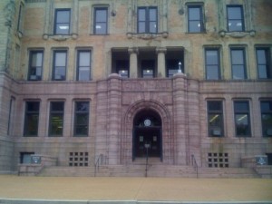
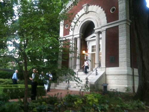
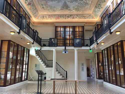
The library building at the Missouri Botanical Gardens is one of the original structures from when Henry Shaw opened his private gardens to the public in 1859 — 160 years ago.   It’s a small structure, as the gardens expanded it simply outgrew it. It was rarely opened after being closed.

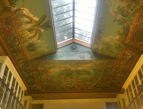
Since Shaw’s death in 1889, the building has served many functions—from research lab to offices to restaurant. Since its closing in 1982, it’s only open on special occasions, such as Shaw’s birthday celebration each July 24.  (Missouri Botanical Garden)

I was fortunate enough to get to see the interior on a rare opening on July 10, 2011.  This meant leaving my wheelchair as the bottom of the steps and using the handrails to walk up the steps. It was worth the effort.

The Museum Building: Commissioned by Henry Shaw in 1858, this neoclassical building was designed by George I. Barnett and modeled after a building at the Royal Botanic Gardens at Kew, England. Originally, this building served as a small natural history museum, and housed the library.
Interior in June 2011

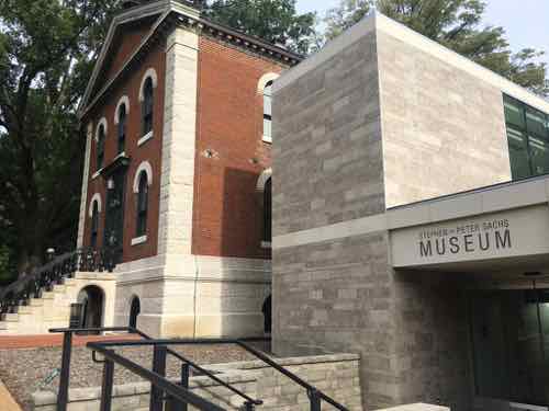
They planned a restoration project and addition to make the building accessible. Adding onto a significant historic building, especially one designed by a noted architect, is very tricky. Most people, I think, probably assume it’s best to use the same materials & style  — to try to blend in. That’s the opposite of what is recommended!

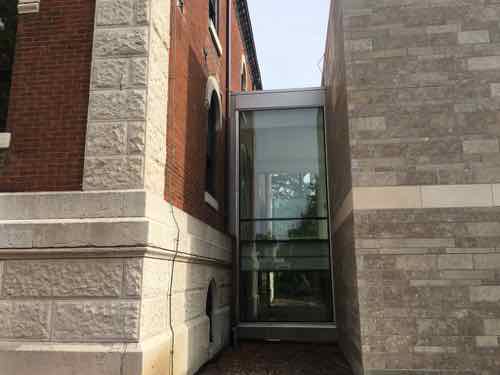
Instead you want to use modern materials from current times. It’s best to not do irreversible damage where adding on.

This view shows the original on the left with the 2018 addition on the right. A glass connector attaches addition to the historic. South facade.

I’ll let the architects behind the project explain the addition:

The 2,150 square foot addition is designed with a contemporary use of stone, distinguishing it from the existing building and reflecting current building technologies and materiality.  A glass volume creates a formal entry on the north façade while the south façade is comprised of a modern limestone finish.  The limestone masses define transparent entries both on the north and south facades.  As a whole, the addition is simple, yet unique; providing much-needed access and facilities in a building that subtly complements the original historic structure. (Christner)

As you approach the historic main entrance from the North you’re directed toward the left.

You see this sign first.
You turn and see the addition, the garage on the left is old — but not historic.
Approaching the entrance you can see through to the South entrance. This view shows an upper floor of glass walls.
Looking back North from inside the upper level — the glass box is where the stairs come up. The elevator is behind me.
No matter how you get up one level, this is what you see. A little bit of the outside wall is now inside. A former window becomes the opening into the main historic space.
This is looking North, toward the original main entrance doors.
This is the view looking South. The new addition is accessed at the back left, just past the bookcase. The upper level mezzanine is not open to the public.
In the back (south) room a vaulted ceiling had been hidden for decades by a dropped plaster celling.
Built-in shutters on the sides of the windows in the back space.
Back at the South side you can see how stone on the addition conceals the elevator.

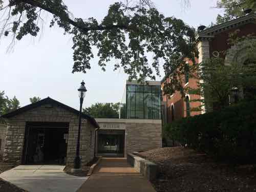
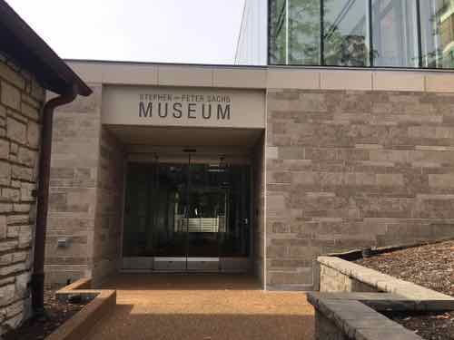
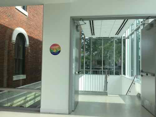
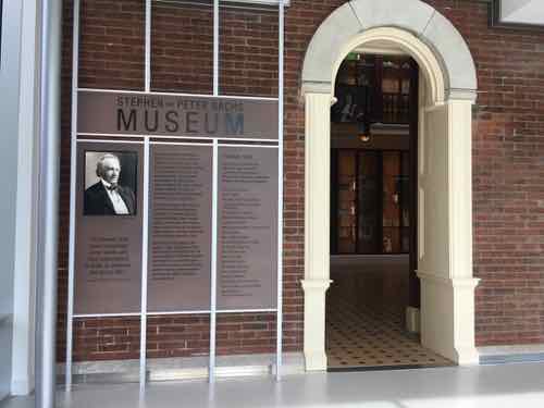
The addition not only provides access to the historic spaces, it also provides much-needed restrooms & drinking fountains on the East side of the garden. It opened last year, but it was only recently I got to see & experience it.

I’m so glad so many parents use baby strollers in public, it’s an added incentive to makes spaces accessible to everyone. Kudos to everyone involved with this project.

— Steve Patterson


St. Louis Board of Aldermen: New Board Bills Week 13 of 2018-2019 Session, Last Meeting Before Summer Break

July 13, 2018 Board of Aldermen, Featured Comments Off on St. Louis Board of Aldermen: New Board Bills Week 13 of 2018-2019 Session, Last Meeting Before Summer Break
St. Louis City Hall

The St. Louis Board of Aldermen will meet at 10am today, their 13th meeting of the 2018-2019 session. Today is their last meeting prior to Summer break.

Today’s agenda includes two new bills:

  • B.B.#98 – Davis – An Ordinance recommended and approved by the Airport Commission, the Board of Public Service, and the Board of Estimate and Apportionment authorizing a Third Amendment to Section One of the Airport Schedule F CIP Project Ordinance 67357 approved December 19, 2006, as amended by Ordinance 68650 approved June 2, 2010 and Ordinance 68852 approved February 14, 2011, which authorized a multi-year public work and improvement program at St. Louis Lambert International Airport,amending EXHIBIT A entitled “Schedule F CIP Project (MII Approved)” by adding a new project to the project list entitled “Replacing Accounting Systems”; and containingseverability clause and an emergency clause
  • B.B.#99 – Ogilvie – An Ordinance recommended by the Board of Public Service authorizing the Mayor and Comptroller of the City of St. Louis to execute an Easement Agreement, which shall give, grant, extend and confer in perpetuity on the City, its Agents, Successors and Assigns, the right to install, construct, maintain, repair, and upgrade a water Main for the purpose of delivering water; approving an Easement Agreement for a perpetual easement; authorizing certain actions by City officials, and containing a severability clause.

The meeting begins at 10am, past meetings and a live broadcast can be watched online here. See list of all board bills for the 2017-2018 session — the new bills listed above may not be online right away. The next full board meeting after today will be September 7, 2018.

— Steve Patterson


An Example Of How The St louis Region Fails Pedestrians, Transit Users

Part of the implied contract when taking a bus to a destination is when you’re dropped off at your stop, you’ll be able to get to the corresponding stop in the opposite direction for the return trip. Seems simple enough, right? But in many parts of the St. Louis region being able to reach a bus stop in the opposite direction is impossible if you’re disabled. I don’t go looking for them, I run across them just going about my life.

Since the Americans with Disabilities Act of 1990 became law, transit operators, like Metro St. Louis, formerly Bi-State Development Agency, have equipped their fleet of buses with either a lift or ramp in new low-floor models. This permits those us who use wheelchairs to board every bus with access to hundreds of routes throughout the region — theoretically, at least. Bus routes are operated on municipal/county roads throughout our region. The responsibility for these public rights-of-way (PROW) are that of the municipality, county, or state — depending upon the entity that has assumed responsibility. Regardless, the transit agency generally isn’t responsible for the pedestrian infrastructure (sidewalks, curb cuts. etc) to/from their bus stops.

Today’s example involves a 2.5 mile stretch of Manchester Ave from McCausland Ave to Kingshighway Blvd — all in the City of St. Louis. A third of this stretch is fronted by the St. Louis Marketplace — a strip retail center that opened in 1992 — it was St. Louis’ very first TIF project. A former industrial area was reclaimed for retail by relocating railroad tracks further away from Manchester. The entire site was new from scratch and post-ADA.  Furthermore, Manchester Ave has had a bus route for the entire 26 years I’ve lived in St. Louis — probably for at least 3-4 decades. For years it was the #59, but after the Cross County MetroLink line opened in 2006 the #59 stops at Maplewood and the #32 was extended West to Maplewood.

The morning of August 11th my husband forgot his phone, so I decided to take it to him. His morning client lives a few blocks North of Manchester Ave. in the Franz Park neighborhood (aka Dogtown), 24th ward. With my car key I was able to leave his phone in the door pocket and a note on the seat. I needed to return to Manchester Ave and catch the #32 Eastbound.

I crossed Manchester at the light at Prather Ave, Google maps told me the stop was to the right. Thankfully ramps were built.
Looking West toward the bus stop
Thankfully my chair had enough power to roll over the grass. If it had been wet or muddy I couldn't have reached this bus stop . A user of a manual chair probably couldn't have. and finally, why should ab;e-bodied pedestrians have to walk through grass? The bus stop sign is attached to the light post.
Thankfully my chair had enough power to roll over the grass. If it had been wet or muddy I couldn’t have reached this bus stop . A user of a manual chair probably couldn’t have. and finally, why should ab;e-bodied pedestrians have to walk through grass? The bus stop sign is attached to the light post.

When I boarded the bus from this stop the driver asked me how I managed to get to the stop!  On the bus I noticed a stop further East that I’ve blogged about before.

A bench head been casually placed at the stop, partially blocking the pad that was barely big enough for a wheelchair user to turn around.

I paid attention to all the stops as we passed each one. I decided I needed to look at the entire stretch, not just one stop here or there. Again, the distance between Kingshighway and McCausland is 2.5 miles. There are 12 MetroBus stops in each direction.  All 12 in the Westbound direction are accessible — not ideal but adequate.  However, in the Eastbound direction only half are accessible/adequate.

Six aren’t accessible, although I was able to power through the grass to reach one of them. Four of these six inaccessible bus stops are in front of the St. Louis Marketplace, the retail development that was created 100% from scratch after the ADA became law. Let’s take a look.


Starting at Ecoff Ave on the West edge of St. Louis Marketplace, you can see the curb ramp in the lower right corner but it leads to grass not sidewalk
My guess is either the city or developer were supposed to add a sidewalk
This is the stop I used on August 11th
The next EB stop has a place for the bus to pull over and a shelter -- the city & Metro planned ahead for this stop
The next EB stop has a place for the bus to pull over and a shelter — the city & Metro planned ahead for this stop
The back side shows a curb prevents access from the parking lot
The next stop also has a space for the bus and a shelter, but no sidewalk along Manchester
This looks accessible. right?
Like the previous stop, a curb prevents access from the parking lot
The last of the four stops in front of the shopping center also has a shelter. Here you can see concrete was recently added -- the old walkway next to the shelter was too narrow to meet the ADA minimum.
The last of the four stops in front of the shopping center also has a shelter. Here you can see concrete was recently added — the old walkway next to the shelter was too narrow to meet the ADA minimum.
Oh yes, it's wide enough now, But no sidewalk leading to the bus shelter and shrubs are at the back
Oh yes, it’s wide enough now, But no sidewalk leading to the bus shelter and shrubs are at the back
Charter vans blocked my view of the walkway but it's safe to assume it has a curb like the two previous stops.
Charter vans blocked my view of the walkway but it’s safe to assume it has a curb like the two previous stops.
The next stop East of the shopping center isn't accessible at all
The next stop East of the shopping center isn’t accessible at all
But yes, Metro added a wheelchair pad in a recent round of ADA improvements. I guess we're expected to cross Manchester between signals to reach this stop? If I'm heading EB would a driver let me off at this stop? Anyone using this stop risks getting hit crossing Manchester.
But yes, Metro added a wheelchair pad in a recent round of ADA improvements. I guess we’re expected to cross Manchester between signals to reach this stop? If I’m heading EB would a driver let me off at this stop? Anyone using this stop risks getting hit crossing Manchester.
The bench that was blocking the stop at Hampton was moved after I tweeted about it, but seating is needed -- just not blocking the pad.
The bench that was blocking the stop at Hampton was moved after I tweeted about it, but seating is needed — just not blocking the pad.
And the 6th inaccessible stop is just East of Macklind
Metro also poured a pad here even though there's no safe way to reach it.
Metro also poured a pad here even though there’s no safe way to reach it.

Previous posts on a couple of bus stops on this stretch of Manchester:


Gee, I wonder why few walk or use public transit? Seems so inviting…

— Steve Patterson


Downtown>Hampton>IKEA>Downtown Part 2

Yesterday, in Part 1, I talked about the two different transit I’d taken (MetroLink, #90 & #32 MetroBus) and issues faced as a pedestrian trying to navigate in between.  I’d made it to IKEA for shopping, followed by lunch.

I'm obsessed with food so naturally I took a pic of my plate: Veggies balls with vegetarian black bean sauce,, steamed veggies, Swedish apple cake, and tap water.
I’m obsessed with food so naturally I took a pic of my plate: Veggies balls with vegetarian black bean sauce,, steamed veggies, Swedish apple cake, and tap water.
When I was done with lunch the rain had resumed.

I checked the transit options, it would be a while before a MetroBus stopped out front. Plus, that would only get me to Lindell where I’d have to wait in the rain for the #10. The Grand MetroLink is closer than the CWE MetroLink, but Forest Park is the most direct route and I recall some access issues the last time. Plus, my transfer from earlier was now long expired.

No matter what I’d be in the rain, so I decided to just roll home — 2.9 miles. I’ve done it a few times before, though not in the rain. I’m still wearing a poncho to keep me and the controller on my chair dry. My shoes, however, get soaked.  North on Vandeventer to Lindell. I stayed on the West side of Vandeventer because I’m bot sure if the city ever got around to the huge gaps in front of the curb ramps on the NE corner of Vandeventer & Forest Park. At Lindell, I checked the schedule again — I can get home before the next bus would arrive.

Because of the rain I only took a few pictures. The following week I took the bus to Lindell & Spring to backtrack and take pictures of things I saw in the rain.

Lindell & Spring, the crowd passed the walk button. Not sure if required.
New traffic signals being installed at the Lindell/Olive intersection. April 6th
This signal is long overdue! In the background the Hotel Ignacio is getting its EFIS facade repaired
How many years ago did I post about the need for painted crosswalk lines here? August 2011 -- click image for post.
How many years ago did I post about the need for painted crosswalk lines here? August 2011 — click image for post.
Olive & Compton, no need to push the button tho cross Compton. If you want to cross Olive you must press the button.
At Ewing is a ramp my powerful chair cannot get up -- the vertical height is too much. April 6th
At Ewing is a ramp my powerful chair cannot get up — the vertical height is too much. April 6th
The same ramp again. Like hundreds/thousands of curb ramps it was built too high relative to the paving. Plus, like so many, the paving right in from is partially missing. I have to role in Ewing a little bit to get to a driveway.
The same ramp again. Like hundreds/thousands of curb ramps it was built too high relative to the paving. Plus, like so many, the paving right in from is partially missing. I have to role in Ewing a little bit to get to a driveway to get onto the sidewalk.
The West side at Ewing & Olive is another issue. The concrete at the top has caved in. .
The West side at Ewing & Olive is another issue. The concrete at the top has caved in between the top of the ramp and the access panel.
I've not tried to go up this ramp. it might also be impossible
I’ve not tried to go up this ramp. it might also be impossible
At Leffingwell you must press the button to get a walk signal to cross Olive -- even when traffic has a green light
At Leffingwell you must press the button to get a walk signal to cross Olive — even when traffic has a green light
At Olive & 20th I saw the buttons in the rain, they were far away. To cross 20th you needed to be over by Olive and vice versa.
When I went back I confirmed no button is needed to cross 20th but you do need to press a button top cross Olive. The signs are wrong, the button next to each crosswalk is what is wired.

Used to be — but no curb ramp is missing for the nearly 3 mile trip. If I tried to use Locust there are many missing curb ramps.

I still fail to understand why all the cost of the buttons when they don’t need to be pushed in the East-West direction. And why have to press a button to get a walk signal when vehicles from side streets get a green light?  This is how we’ve spent money — building infrastructure that frustrates this pedestrian!

— Steve Patterson


Downtown>Hampton>IKEA>Downtown Part 1

The morning of April 6th I had a 9am appointment on Hampton Ave, between Columbia & Elizabeth. It was raining off and on that day. Today’s post is about the journey there & back.

I had originally planned to take MetroBus there, but I didn’t have any two-hour passes so I’d get a transfer for the 2nd bus. So I went to the Union Station MetroLink station, purchased a few passes, validated one, boarded a Westbound train to the Forest Park MetroLink station. Just before a Southbound #90 (Hampton) MetroBus arrived it began to sprinkle. I left home in a poncho to keep  and my wheelchair’s controller dry.

View out a Southbound #90 MetroBus on Hampton about to cross over I-64. Traffic was backed up on the highway and WB on ramp

After taking care of business at two places on Hampton, I wanted to visit IKEA to shop and have lunch. The most direct route was a short ride on a Northbound #90 (Hampton) MetroBus, then take a #32 (Chouteau-Manchester) MetroBus to Vandeventer. But when I was ready to leave it was going to be a while before the next #90 arrived, I might as well just roll it.

I’ve gone up to Clayton Ave before, so I knew  I could manage — it was about 3/4 of a mile from my starting point to Lloyd Ave. where I’d go right to make my way down to Manchester (map).   As I turned off Hampton onto Lloyd I was pleasantly surprised a sidewalk existed — I wasn’t sure that would be the case. However, a the bottom of the hill there was no sidewalk along Sulphur. Well, there is along the East side, but because of curbs, I couldn’t get to it.

At this point I had two options:

  1. Roll on the Sulphur Ave roadway, or
  2. Go back up to Hampton, cross, reach Manchester on the other side.

Looking at the time I thought I’d miss the next #32 if I went with the safer #2 option. So, when there was no traffic I quickly rolled South to Manchester. Whew…

The ADA ramp to cross Manchester is covered in a fine gravel. I can power over it but others would have difficulty.
Looking back where I'd been
Looking back where I’d been
The EB MetroBus stop. I wish it had a curb at the far right edge to prevent backing up too far and rolling down the hill.
Looking West to see the #32 coming. In September I posted about the danger of reaching one bus stop to the West -- clock image to view that post
Looking West to see the #32 coming. In September I posted about the danger of reaching one bus stop to the West — clock image to view that post

So the #32 MetroBus came right on time, my transfer was still valid, and it had stopped raining. I’d get off at Vandeventer Ave and roll North to IKEA — about a half a mile. So I got off at the last MetroBus stop before Vandeventer Ave., just had to cross one side street first.

Hemp Ave is between the bus stop and Vandeventer, but no curb ramp is visible. But be just out of view
Nope, just 100 feet from a bus stop there's no curb cut! I found a driveway I was barely able to use to get onto the sidewalk
Nope, just 100 feet from a bus stop there’s no curb cut! I found a driveway I was barely able to use to get onto the sidewalk
Looking North I'd hoped to cross here to stay on the West side of Vandeventer -- but pedestrians aren't allowed ri cross at this point
Looking North I’d hoped to cross here to stay on the West side of Vandeventer — but pedestrians aren’t allowed ri cross at this point
So I crossed Vandeventer, them crossed Manchester. The sidewalk design makes it clear to not go East on Chouteau.
QuikTrip thinks this is a compliant pedestrian route. It's not.
QuikTrip thinks this is a compliant pedestrian route. It’s not.
Heading North, but I see a problem ahead. Initially I thought no sidewalk existed after the building on the right
But the tiny sidewalk has been blocked by Laclede Cab. Looking at city records, the public right-of-way is as wide as it is ned to the building -- the sidewalk should be wider!
But the tiny sidewalk has been blocked by Laclede Cab. Looking at city records, the public right-of-way is as wide as it is ned to the building — the sidewalk should be wider!
Continuing, I'm almost to Market St. JJs Clubhouse, a gay bar, is to the right
Continuing, I’m almost to Market St. JJs Clubhouse, a gay bar, is to the right
Turning left, I can see my destination--almost there!
Turning left, I can see my destination–almost there!
Rough surface that would be a challenge for many
When the side on the right is soon developed, this sidewalk will be redone. Still, this was great compared to what I had just experienced
But when IKEA was built one time section was left as gravel and my chair couldn't get up over the vertical edge -- not with me in it. Unlike many, I'm fortunate enough to be able to stand on level ground. So I got up and the chair could then get up to the sidewalk.
But when IKEA was built one time section was left as gravel and my chair couldn’t get up over the vertical edge — not with me in it. Unlike many, I’m fortunate enough to be able to stand on level ground. So I got up and the chair could then get up to the new sidewalk.
Looking back we can see the tiny section left unfinished and inaccessible for more than half a year .
Finally, I can now cross to IKEA.

Combined with public transit, I can cover miles as a pedestrian in my wheelchair — though our public rights-of-way are far from ideal. Looking at Google Maps it suggests using Sarah to reach IKEA instead of Vandeventer — no matter where you start from: Commerce, QuikTrip, Laclede Cab, even JJs Clubhouse! Yes, if you’re at Vandeventer & Market where you can see IKEA it suggests you cross Vandeventer and go West on Clayton Road to Sarah.

This isn’t a lack of money issue — it’s a lack of concern issue. Money is spent building infrastructure that doesn’t work for actual users. This mentality needs to change!

Tomorrow’s post will be about my trip back downtown from IKEA.

— Steve Patterson


Advertisement


[custom-facebook-feed]

Archives

Categories

Advertisement


Subscribe