Home » Mill Creek Valley » Recent Articles:

Corrections to the Mill Creek Valley Narrative

November 29, 2021 Featured, History/Preservation, North City Comments Off on Corrections to the Mill Creek Valley Narrative

I feel the need to correct the record regarding Mill Creek Valley, to counter the false information being repeated.
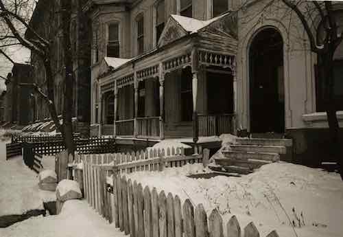
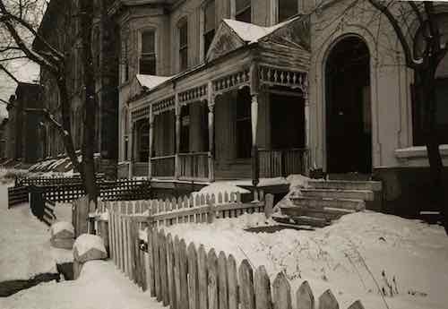
“Horizontal, black and white photograph showing a row of dilapidated residential buildings in the 3200 block of Lawton in Mill Creek Valley. The buildings appear to be empty and awaiting demolition. Low wooden fences enclose the small front yards. There are several inches of snow on the ground.” February 16, 1960. Missouri Historical Society

Though St. Louis was founded in 1764 it wasn’t incorporated until 1823. At that time “the city limits were expanded west to Seventh Street and north and south by approximately 5 blocks each.” (Wikipedia) In 1861 the limits were expanded west to Grand, but streets and development had already gone further west. The land for Forest Park was purchased in 1875 — it was located in St. Louis County, not within the city limits of St. Louis. The current municipal boundaries were set in the 1876 divorce from St. Louis County, they were rural at the time.

There was no singular cohesive Mill Creek Valley neighborhood. The large rectangular area (454 acres) the city demolished for “urban renewal”, bounded by 20th St, creek/railroad, Grand Ave, Olive St., included many communities, businesses, homes, etc. was built over many decades — neighborhoods plural. Our modern perception of neighborhoods having distinct edges didn’t exist then, your neighborhood was where you lived. People who lived between 20th & Jefferson didn’t see their area belonging to the newer area west of Compton. The fact this large area ended up being grouped together and labeled by the city as a redevelopment area doesn’t make it a single neighborhood.

Commonly the word “downtown” refers to a city’s central business district (CBD). The size/location of “downtown St. Louis ” varies depending upon who you ask. To some anything east of I-270 is downtown. When St. Louis Union Station reopened at its new facility on September 1, 1894 it was considered far west of the CBD/downtown. The original station, on the east side of 12th (now Tucker), opened on June 1, 1875.

Thus, the Mill Creek redevelopment area wasn’t the heart of downtown. Not even close. Starting at 20th and going west, it wasn’t the oldest part of the city either. The stately row houses in this area were significantly newer and nicer than the tenements east of 10th Street. It was certain old by the 1940s, just not the oldest. It was also dense and lively, with everything within a short walk. Market Street ran down the center of the rectangular redevelopment area and contained the majority of the commercial activity, but corner shops also existed.

Since the city’s founding African-Americans lived in tight pockets throughout the city and St. Louis County. The black population before the Civil War was a very small percentage.

Not all persons of color in St. Louis were slaves, and in fact, as the 19th century progressed, the number of free blacks continued to rise. This can be explained by looking at several factors. Conditions in St. Louis enabled self-purchase. St. Louis’ proximity to Illinois, a state where slavery was supposed to be illegal, allowed a small number of slaves to sue for their freedom in St. Louis courts based on the premise that they had been held as slaves for a period of time in a free state. A very small number were also set free by masters who had come to see slavery as a moral wrong. Former slaves who wished to remain in the State of Missouri as free blacks were supposed to obtain a license from the state.

In addition to the over 1,000 free blacks in St. Louis who owned small businesses, were laborers or worked odd jobs, a certain elite group of African-American St. Louisans styled “the Colored Aristocracy” were large landowners and businesspersons, many descended from some of St. Louis’ earliest residents. Several owned the large barber emporiums, while others owned drayage businesses which moved goods from steamboat to steamboat on the levee. Still others, like Madame Pelagie Rutgers, owned huge tracts of land which they sold at great profit as the city expanded. The “Colored Aristocracy” of St. Louis had its own social season and debutante balls. A member of this social class, Cyprian Clamorgan, wrote a book in 1858 called the Colored Aristocracy of St. Louis, in which he profiled the group. (National Park Service — highly recommended)

Yes, wealthy blacks in the 19th century. They didn’t live in the area we know today as Mill Creek. They lived in The Ville.

During the 1920s, The Ville was home to an elite community that included black professionals, businessmen, entertainers and Annie Malone, one of the country’s first African-American millionaires. One of St. Louis’ most historically significant neighborhoods, The Ville was home to Sumner High School, the first school west of the Mississippi River to provide secondary education for blacks. Some of the school’s best known alumni are Rock ‘n’ Roll Hall of Famer Chuck Berry, opera diva Grace Bumbry, and tennis great Arthur Ashe. During the 1920s and ‘30s, the neighborhood thrived, as more and more African-American institutions were established, including Harriet Beecher Stowe College and Homer G. Phillips Hospital.

The Ville served as the cradle of African-American culture and nurtured its rich heritage for the black population of St. Louis. Today, the soaring Ville Monument pays tribute to the neighborhood’s achievements and its famous sons and daughters. (Explore St. Louis)


Sumner High School, mentioned above, opened downtown on 11th between Poplar & Spruce in 1875 — the same year as the adjacent first new Union Station mentioned earlier:

Charlton Tandy led protests of the planned siting of Sumner High School in a heavily polluted area in close proximity to a lead works, lumber and tobacco warehouses, and the train station as well as brothels. He said that black students deserved clean and quiet schools the same way white students do. The location went unchanged, and Sumner High opened in 1875, the first high school opened for African Americans west of the Mississippi. The school is named after the well-known abolitionist senator Charles H. Sumner. The high school was established on Eleventh Street in St. Louis between Poplar and Spruce Street, in response to demands to provide educational opportunities, following a requirement that school boards support black education after Republicans passed the “radical” Constitution of 1865 in Missouri that also abolished slavery.

The school was moved in the 1880s because parents complained that their children were walking past the city gallows and morgue on their way to school. The current structure, built in 1908, was designed by architect William B. Ittner. Sumner was the only black public high school in St. Louis City until the opening of Vashon High School in 1927. Famous instructors include Edward Bouchet and Charles H. Turner. Other later black high schools in St. Louis County were Douglass High School (opened in 1925) and Kinloch High School (1936). (Wikipedia)

Sumner High was an 1867 school renamed. Originally it was District School Number Three. Source: 1960 handbook.

Locations:

  • 1867, 5th & Lombard
  • 10th & Chambers
  • 1875, 11th & Spruce — now known as Sumner instead of #3.
  • 1896, 15th & Walnut
  • 1908 construction on the current location in The Ville neighborhood began
  • 1910 classes began, moving from 15th & Walnut.

Wealthy blacks in St. Louis were successful in relocating Sumner t0 their neighborhood, where their homes and businesses were located.

Another well-known institution in The Ville was Homer G. Phillips Hospital.

Between 1910 and 1920, the black population of St. Louis increased by sixty percent, as rural migrants came North in the Great Migration to take industrial jobs, yet the public City Hospital served only whites, and had no facilities for black patients or staff. A group of black community leaders persuaded the city in 1919 to purchase a 177-bed hospital (formerly owned by Barnes Medical College) at Garrison and Lawton avenues to serve African Americans. This hospital, denoted City Hospital #2, was inadequate to the needs of the more than 70,000 black St. Louisans. Local black attorney Homer G. Phillips led a campaign for a civic improvements bond issue that would provide for the construction of a larger hospital for blacks.

When the bond issue was passed in 1923, the city refused to allocate funding for the hospital, instead advocating a segregated addition to the original City Hospital, located in the Peabody-Darst-Webbe neighborhood and distant from the center of black population. Phillips again led the efforts to implement the original plan for a new hospital, successfully debating the St. Louis Board of Aldermen for allocation of funds to this purpose. Site acquisition resulted in the purchase of 6.3 acres in the Ville, the center of the black community of St. Louis. But, before construction could begin, Homer G. Phillips was shot and killed. Although two men were arrested and charged with the crime, they were acquitted; and Phillips’ murder remains unsolved.

Construction on the site began in October 1932, with the city initially using funds from the 1923 bond issue and later from the newly formed Public Works Administration. City architect Albert Osburg was the primary designer of the building, which was completed in phases. The central building was finished between 1933 and 1935, while the two wings were finished between 1936 and 1937. The hospital was dedicated on February 22, 1937, with a parade and speeches by Missouri Governor Lloyd C. Stark, St. Louis Mayor Bernard Francis Dickmann, and Secretary of the Interior Harold L. Ickes. Speaking to the black community of St. Louis, Ickes noted that the hospital would help the community “achieve your rightful place in our economic system.” It was renamed in 1942 from City Hospital #2 to Homer G. Phillips, in his honor. (Wikipedia)

Prior to Homer G. Philips Hospital in the Ville, an existing building was used as City Hospital #2 between 1919-1936. That 19th century building was at Garrison & Lawton. That intersection no longer exists. Lawton was an east-west street between Pine and Laclede, known as Chestnut east of Jefferson. So yes, the first hospital for blacks in St. Louis was within the boundaries of the Mill Creek redevelopment area, for 17 years. Then the significantly larger City Hospital #2 opened in the Ville — where the wealthier black families lived.
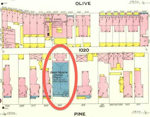
February 1909 Sanborn Map showed a stone (blue) church at 3015 Pine, labeled “Berea Presby’n Church (Negro)”. This is one the few buildings to survive the clearance of the Mill Creek redevelopment area.

As stated at the beginning, black residents lived in small pockets throughout the city. Wealth, social class, and geography separated the residents of the Ville from those in the older Mill Creek redevelopment area.

This is not to say every black person living in The Ville was wealthy, that was not the case. As poor blacks moved north to escape the Jim Crow south they likely lived where they could, including in The Ville. I know of one family that lived in The Ville during the 1940 census that had migrated from Alabama. I’d love to see maps showing where black persons lived in the region following the Civil War, showing shifts each decade.  The change from 1950 to 1960 would give us better information on where families displaced by the demolition of Mill Creek relocated.

We know white home owners in the areas immediately outside The Ville had racially restrictive covenants on their properties since the early years of the 20th century. One block, now part of the Greater Ville neighborhood, was still white when the Shelley family had a white person act as the buyer so they could purchase 4600 Labdie in 1945. In 1948 the U.S. Supreme Court ruled the court system couldn’t be used to enforce restrictive covenants (Shelley v Kraemer).

This prompted many white homeowners surrounding The Ville to sell and move further away. At the same time people were being forced to leave the  Mill Creek Valley redevelopment area many more options were available on the city’s north side.  Yes, some may have moved into numerous high-rise public housing projects that were open prior to the February 16, 1959 start of demolition in Mill Creek.

  •  Cochran Garden Apts, April 1953
  • Pruitt-Igoe, 1955
  • (In December 1955) a judge ruled St. Louis and the housing authority had to stop segregation in public housing.
  • Vaughn Apts, October 1957

The low-rise Neighborhood Gardens and Carr Square Village opened in May 1935 and August 1942, respectively. Again, segregated until 1956. One of the problems with large-scale demolition is people get scattered in the process.

The demolition was certainly a land grab, no question. Wealthy whites living west in the Central West End, Clayton, Ladue, etc had to drive on Market Street to reach Union Station and the CBD. They didn’t like driving through old dense areas, especially predominantly occupied by African-Americans.

Back east demolition was increasingly happening. Soldiers Memorial opened in 1938, Aloe Plaza opened two years later — both on the north side of Market Street. St. Louis leaders got hooked on demolition so clearing out the west entry to downtown followed. Also in the late 1930s the Oakland Express opened, a highway from Skinker to Vandeventer & Chouteau.

Hopefully the incorrect information will cease.

— Steve Patterson

 

New Book: ‘The Last Children of Mill Creek’ by Vivian Gibson

April 15, 2020 Books, Featured Comments Off on New Book: ‘The Last Children of Mill Creek’ by Vivian Gibson

Mill Creek, a vibrant African-American neighborhood, destroyed by Urban Renewal, is one of my favorite St. Louis subjects. So when the publisher contacted me for a review copy of ‘The Last Children of Mill Creek’ I quickly said yes.
A true story of growing up in segregated St. Louis, The Last Children of Mill Creek is the debut memoir by a talented writer finding her authentic voice later in life.

Vivian Gibson is a native St. Louisian who grew up in Mill Creek Valley, a neighborhood of St. Louis razed in 1959 to build a highway. Her family, friends, church community, and neighbors were all displaced by this act of “urban renewal.” In this moving memoir, Gibson recreates the everyday lived experiences of her large family, including her seven siblings, her crafty college-educated mother, who moved to St. Louis as part of the Great Migration, and her at-times forbidding father, who worked two jobs to keep them all warm and fed. With an eye for telling detail, she sketches scenes populated by her friends, shop owners, teachers, and others who made Mill Creek into a warm, tight-knit, African-American community, and reflects upon what it means that Mill Creek was destroyed in the name of racism disguised as “progress.”

The Last Children of Mill Creek is a moving memoir of family life at a time very different from the modern-day, when many working-class African-American families did not have indoor plumbing and when sundown laws were still in effect—and a document of an era that is now often forgotten or denied. In Gibson’s words, “This memoir is about survival, as told from the viewpoint of a watchful young girl —a collection of decidedly universal stories that chronicle the extraordinary lives of ordinary people.” (Belt Publishing)

A family memoir isn’t the usual type of book I’d look at on this blog. It only has one photo, a family photo of a mom reading to kids. No photos of buildings, no maps or charts. Gibson does mention their neighborhood being vacated and razed, but only to provide context.

I’m very glad I didn’t turn it down.

I usually just scan books, but this book I read cover to cover. Yes, it’s a short book — but it still took me a week (post-stroke reading is a challenge for me). Gibson does a wonderful job of introducing the reader to her family and their home that was at  2649 Bernard Street. In doing so she also describes the Mill Creek neighborhood.

Gibson lived with her parents and seven siblings in a 3-room cold-water flat, her paternal grandmother lived alone in the upstairs flat. Yes, a family of 10 lived in just three rooms. Well, her brothers stayed in the basement. Their flat was basically beds and a kitchen. A single light bulb per room. And rats.

With overcrowding into flats lacking hot water, but with plenty of rats, Mill Creek was a slum, right? No, Gibson’s descriptions of her street, neighborhoods, businesses, churches, schools, etc. is of a wonderful tight-knit neighborhood.

Once the current pandemic is over I want to meet Gibson to ask her more about the buildings, blocks, and businesses. In the meantime I’m going to start reading the book again, taking note of the many details she does give. I’d like to see another book — or a film — about the neighborhood.

Many of you likely saw The Pruitt-Igoe Myth, about the failed high rise public housing project. I think someone needs to do a film/documentary about life in neighborhoods a generation before they were razed.  Mill Creek is a good place to start.

Gibson’s book beautifully describes life growing up in Mill Creek, it saddens me it was physically erased. I can’t recommend this book enough, very enjoyable. I’ve spent many more hours thinking about it than reading it.

— Steve Patterson

b

b

b


Mill Creek Valley Neighborhood Was Less Important Than An Expressway

February 19, 2020 Featured, Urban Renewal Comments Off on Mill Creek Valley Neighborhood Was Less Important Than An Expressway

Since his arrival in St. Louis in 1915 Harland Bartholomew, a civil engineer by training, wanted cars to be able to move with greater ease. He relentlessly argued in favor of  destroying the city’s rich urban fabric, street grid, in order to save the city from urban decay. He was young and charismatic, convincing generations of St. Louisans his way was the only way.

“Horizontal, black and white photograph showing a row of dilapidated residential buildings in the 3200 block of Lawton in Mill Creek Valley. The buildings appear to be empty and awaiting demolition. Low wooden fences enclose the small front yards. There are several inches of snow on the ground.” February 16, 1960. Missouri Historical Society

Lawton was an east-west street between Pine & Laclede, the above would’ve been just west of Compton Ave.

The chaos created by decades of Bartholomew’s projects created so much instability — far worse than than anything natural decay was creating. Widening streets and building new expressways was part of Bartholomew’s vision. It was costly but necessary, he argued.

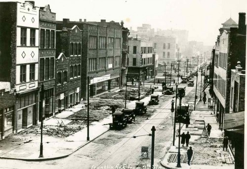
North edge of downtown: Franklin Ave being widened, looking East from 9th, 1928. Collection of the Landmarks Association of St Louis

In 1936 the first phase of a new expressway opened between Kingshighway and Skinner, cutting through the south edge of Forest Park. This was two decades before the creation of the Interstate Highway System! A year later another section opened between Vandeventer and Kingshighway. Many could see it reaching downtown eventually.

Highway planners in those days drew lines on map to connect the dots, sometimes meandering a bit here and there to avoid an important business, like Anheuser-Busch brewery in the case of what is now known as I-55. Otherwise their lines indiscriminately cut through neighborhood after neighborhood.

As these highways were going through the oldest parts of the city they were also going through the poorest neighborhoods. Older “slum” areas were viewed as obsolete anyway — two birds, one stone. By the 1959s Mill Creek Valley, bounded by Union Station on the east, railroad tracks on the south, Grand on the west, and Olive on the north, was a dense neighborhood.

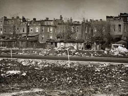
“Horizontal, black and white photograph showing a rear view of dilapidated housing in Mill Creek Valley. View was taken from an area across the street that has already been cleared. Bricks and other rubble is strewn throughout the foreground.” Missouri Historical Society

Because of segregation, it was self-contained. Yes, it was deteriorated and most residences lacked running  water and indoor bathrooms.  The buildings were nearly a century old. Numerous generations of new immigrants had begun their lives in America in this neighborhood, the last was southern blacks trying to escape Jim Crow laws while looking for work.

To an outsider it likely seemed like a horrible place, but to residents it was home. They had connections with each other, lasting institutions, etc. Poor neighborhoods all over the city were the same way, they didn’t look like much but it was the ties among the residents that was more important than the street grid or buildings. But take away the buildings and the streets and those strong ties among thousands quickly disappear. It’s an unnatural disaster.

During the 1950s, Saint Louis found itself in a fervor over urban deterioration and renewal. Following Mayor Joseph Darst’s 1953 slum clearance in the Chestnut Valley area, Mayor Raymond Tucker initiated a similar project in the adjacent Mill Creek Valley. This area – bounded by 20th Street, Grand Avenue, Olive Street and Scott Avenue – housed a large African-American population, and was at one time the home to such famous African-Americans as Scott Joplin and Josephine Baker. At the start of the 1950s, the Mill Creek Valley house 20,000 inhabitants (95% African-American) and included over 800 businesses and institutions. Everything the residents needed – from grocery, clothing and hardware stores to restaurants, schools and churches – was within walking distance of their homes. The area was also home to the prominent African-American newspaper, The St. Louis Argus. However, many of these residences and institutions were considered unsanitary and in need of repair.

In 1951, Missouri Governor Forrest Smith signed the Municipal Land Clearance for Redevelopment Law, which brought state aid to the urban renewal efforts of Missouri’s cities. The law also created the St. Louis Land Clearance for Redevelopment Authority, whose job it was to oversee urban renewal in Saint Louis and manage its funding. Under the 1954 Federal Housing Act – which provided federal aid for renewal projects – and the passage in 1955 of a $110 million bond issue, Mayor Tucker and the City of St. Louis began the clearance and demolition of slums in Mill Creek Valley. The most of the bond revenue went towards construction of new expressways, some of which cut through parts of Mill Creek. Roughly $10 million was utilized for slum clearance. The clearance of the area would involve the relocation of many residents and businesses; most residents would never return and many businesses would cease operations. Acquisition of buildings, like the Pine Street Hotel and the Peoples Finance Building, began in August of 1958, with actual demolition starting the following year. Redevelopment of the area would include new residential, commercial and industrial zones, with the majority of land going towards new industry. Certain industries that met zoning requirements, like Sealtest Foods, would not face demolition and were allowed to stay. Redevelopment of the entire area was scheduled for completion in 1968. (UMSL)

The city systematically created disasters all over the place. The pace must’ve been overwhelming to many at the time. Hundreds of thousands were uprooted. It’s a formula for the population losses that have happened since.

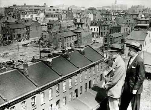
“Horizontal, black and white photograph showing Mayor Raymond Tucker and Sidney Maestre on a rooftop looking over dilapidated buildings slated for clearance in Mill Creek Valley. A note on the back of the print reads: “Mill Creek Valley, 1956 / Mayor Raymond Tucker and Sidney Maestre, Chairman of Citizens Committee which drafted bond issue program, are looking over decaying buildings in blighted area.””

Mill Creek Valley was at the wrong place at the wrong time. By 1950 Bartholomew was in Washington D.C., but his raze & replace attitude continued. Other options weren’t considered, especially when the land is needed for an expressway to connect downtown to affluent western suburbs as the wealthy continued moving westward along the central corridor.

Here are the results of the recent non-scientific Sunday Poll:

Q: Agree or disagree: Mill Creek Valley was a slum (no indoor plumbing, etc); leveling it was the only option

  • Strongly agree: 0 [0%]
  • Agree: 1 [5.56%]
  • Somewhat agree: 1 [5.56%]
  • Neither agree or disagree: 0 [0%]
  • Somewhat disagree: 1 [5.56%]
  • Disagree: 4 [22.22%]
  • Strongly disagree: 10 [55.56%]
  • Unsure/No Answer: 1 [5.56%]

Again, demolition was the only option considered.  One, this generation didn’t see any value in the narrow & compact street grid or in 19th century flats. The other is they really wanted the land for a highway. As a bonus white folks could now drive on Olive & Market streets between the Central West End and downtown without having to go through a black neighborhood.

With so much uprooting & demolition it is amazing we have any residents or buildings left. The leaders at the time just couldn’t/didn’t see the tremendously negative consequences their actions would have on the city & region for decades to come. After all, everything they were doing was in an effort to save the city from decay.

— Steve Patterson


Sunday Poll: Was Razing Mill Creek Valley the City’s Only Option?

February 16, 2020 Featured, Sunday Poll, Urban Renewal Comments Off on Sunday Poll: Was Razing Mill Creek Valley the City’s Only Option?
Please vote below

On February 16, 2013 STL250 shared a 1956 photo of Mayor Raymond Tucker looking at Mill Creek Valley, with the following caption:

This Day in St. Louis History, February 16, 1959:
Mill Creek Valley becomes “Hiroshima Flats”

With $7 million from a 1955 St. Louis Civic Progress bond issue and $21 million in federal funds, the Land Clearance Redevelopment Authority began clearing the 454 acres of Mill Creek Valley, from Lindell on the north and Scott on the south, and Twentieth on the east and Grand on the west. The historically black area’s homes and dilapidated buildings were razed for 132 acres of industrial sites, 26 acres of commercial, 83 acres of residential, a 22 acre extension of St. Louis University across Grand, and the Ozark Expressway. 1,772 families and 610 individuals were displaced, some of the poorest in the city, and almost all black. Slow redevelopment after the rather quick destruction gained the giant empty fields of land the nickname of “Hiroshima Flats.” The Mill Creek Valley site is now covered by the portion of St. Louis University east of Grand, Harris Stowe State University, and the Wells Fargo Advisors buildings.

Here’s more:

By World War II, Mill Creek’s tenements and faded town houses were home to nearly 20,000 people, many of them poor blacks who had migrated north from the cotton fields. More than half the dwellings lacked running water, and 80 percent didn’t have interior bathrooms.

Tucker proposed knocking over nearly everything and starting over. In 1955, city voters overwhelmingly approved a $10 million bond issue for demolition, on the promise that the federal government would reimburse most of it. The local NAACP endorsed the idea. Work began on Feb. 16, 1959, at 3518 Laclede Avenue, where a headache ball smashed a house that dated to the 1870s. (Post-Dispatch)

From an upcoming book on Mill Creek Valley:

On December 16, 1950, my grandmother purchased a house from her landlords, Richard and Betty Bennett, at 2649 Bernard Street in Mill Creek for $1,400. She had saved the $100 down payment from her meager salary. Twenty years after leaving Earl, Arkansas, for St. Louis, she would finally have a home of her own with her son, his wife, and their eight children. She would be the last in a long line of owners of the hundred-year-old Italianate- style two-story dwelling.

My grandmother was unaware of the city’s plans when she bought her house in the neighborhood where she had lived since leaving the South. However, politicians, realtors, and religious and business leaders knew what the future held for this 450-acre neighborhood. Egged on by a series of derisive articles in the local media, the city was moving to deem the area “blighted.” The designation would pave the way for the eventual erasure of an entire African American community to make way for an interstate highway to the suburbs.

There you have it, an overview of Mill Creek Valley.  It was sixty-one years ago today that demolition began, so that’s the subject of today’s poll.

This poll will close at 8pm tonight.

— Steve Patterson


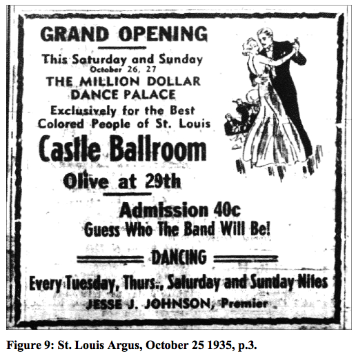
Castle Ballroom: “Exclusively for the Best Colored People of St. Louis”

ABOVE: an advertisement from the National Register nomination (click to view)

Segregation meant blacks had to duplicate all the establishments that were not open to them, including dance halls. One such place was the Castle Ballroom on Olive & 29th (now T.E. Huntley).

Across the street to the south is the Mill Creek Valley Urban Renewal area. This 454-acre tract was the result of a clearance project which razed one of the city’s densest African American neighborhoods beginning in 1959. The low-rise community called Laclede Town was built south of the ballroom in the early 1960s; after subsequent expansions, it was closed in the 1980s and later razed. The property now belongs to the Sigma Chemical Company; most of it is open space. In this context, the Castle can be understood as one of a few remaining buildings with significant associations with the population of Mill Creek Valley.

The nomination to the National Register of Historic Places, quoted above, was written by Lynn Josse.

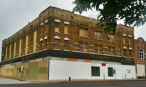
ABOVE: 2839 Olive today

I’d passed by this building thousands of times over the last 20 years but I had no clue to it’s history.  Again from the nomination:

For the purposes of the National Register, the most significant space in the building is the ballroom, which retains integrity. The dance floor, balcony, stage, even much of the plaster and woodwork are largely intact. Although some of the elements may not reflect the 1908 appearance, nearly all are original to the pre-1954 period of significance.

Thankfully the “pent roof” that was added to modernized the building has now been removed.  I can picture new storefront’s and the building occupied again.

Our buildings have so much history, it just takes someone to bring it to our attention.  In my case it was my friend Leigh Maibes, who has the property listed for sale. I’ve seen dark pictures of the ballroom space but without power I wasn’t able to see inside in person (walking is difficult enough for me in well lit spaces).

The renovation of midtown is moving east and downtown is moving west, in a few years they will meet along Washington, Locust or Olive.  Hopefully all three within a decade.

– Steve Patterson


Advertisement


[custom-facebook-feed]

Archives

Categories

Advertisement


Subscribe