Home » Population » Recent Articles:

How To Address North St. Louis’ Shrinking Population

January 20, 2022 Environment, Featured, Neighborhoods, North City, Planning & Design, Politics/Policy, Transportation, Walkability Comments Off on How To Address North St. Louis’ Shrinking Population
Graphic from November 2020 post showing area predicted to have population loss.

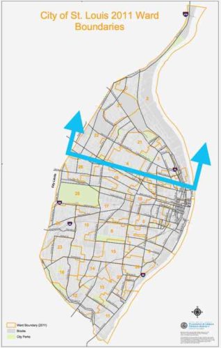
The 2020 Census results results for St. Louis showed what I had predicted, the bulk of our population loss came from northside wards.  This was also true in 2010 and in 2020. No reason to think 2030 won’t be more of the same. We can sit back and do nothing, or we can help manage the situation — possibly reducing some losses in future.

By mange I mean see where population is dropping more than in other areas. We can’t just write of a third of our geographic area. I propose a group comprised of experts, residents, business owners, etc to examine data and evaluate possible solutions.

Here is some of the data I’d like to see on a big map(s):

  • Population by age & race
  • Parcels of land being used (water connection) vs unused.
  • Parcels of land with new or substantially renovated structures vs severally deteriorated, condemned, or vacant.
  • Parcels of land owned by the city, out of state owners, owner-occupied, LLC, .
  • Historic properties, sites.
  • Schools, current & former.
  • Employers and numbers of employees
  • Crime
  • Topography
  • Probably other criteria as well…

Since north city is not declining uniformly we need to see which parts that are doing better than others. Is this because 0f newer housing?  Access to transit?  All we know at this point is some blocks are stable and occupied while others are rapidly declining. Mapped data can tell us a lot, people on the ground familiar with their area can confirm or dispute what the data tells us. Get everyone on the same page, then reassess every few years and make adjustments as circumstances change for better or worse.

What we all need to accept is that it’s very unlikely these neighborhoods will see a major population growth. Ever. Thus some land can be returned to nature, used for agriculture, etc. The maps will show us the least populated areas with the worst housing stock — contrasted with pockets of denser areas with housing unlikely to be abandoned this decade. I’m not talking about large areas the size of Pruitt-Igoe, NGA-West, or Fairgrounds Park. It might be possible that smaller nature areas could be linked together by a trail system. A few great vacant school buildings not reused for residential might get filled with hydroponics to grow produce.

The major corridors like MLK, Page, Natural Bridge, Kingshighway, Grand, etc should remain. Many connecting streets would also remain. However, it’s possible in some areas we might be able to justify removing unoccupied streets and alleys. As St. Louis begins to look at replacing lead water supply lines those areas that’ll benefit most from the infrastructure investment should get priority over areas that can be back to nature by 2030. Old water & sewer lines might get abandoned completely in isolated areas.

The goal isn’t to cut off services to existing residents, but to use resources to strengthen and grow the existing strong pockets. On a block with say only one resident we can wait until that person moves or dies of old age. The children of longtime residents aren’t really interested in moving into the house their relative refused to leave. Conversely, a nice block with one newly-abandoned house needs help to make sure that one house gets maintenance and reoccupied as soon as possible. Quickly reoccupying a vacant building helps prevent others on the block from also being abandoned.

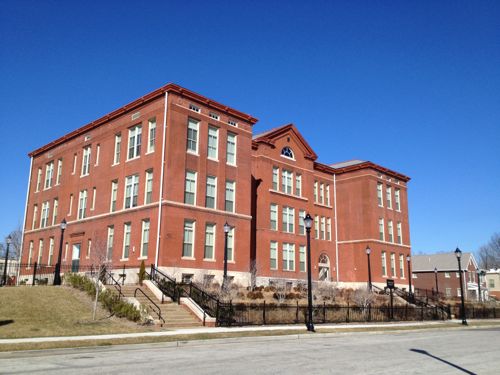
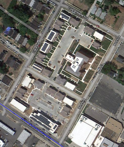
An example of a strong pocket would be MLK & Burd Ave. You’ve the Friendly Temple church and Arlington Grove housing (new housing around a renovated school that’s also housing). Substantial investment has been made, and this is home to many. We can reinforce the positives and look to expand upon that a block at a time.

Former Arlington School has been residential since 2013
Aerial after construction completed. Image: Google Maps

Just north of this pocket is a largely vacant area, part of the Wells-Goodfellow neighborhood that has gotten attention for mass demolitions. Other bright spots throughout north St. Louis include numerous tree-lined streets with well-maintained houses — it’s just hard for everyone to see & appreciate the them with so much decay. Whenever I see people wanting to raze vacant “problem” buildings I do get upset, because tearing down buildings in a random manner doesn’t improve neighborhoods for the long-term. It simply removes the current problem while likely speeding up others being abandoned as neighboring  owners/residents die or move.  By designating different areas for bright spot village and others as moving back toward nature we can reduce fights over razing vs preservation. I can even imagine a decent house in an area set to become nature/agriculture –it might be kept as basically a farmhouse. It wouldn’t necessarily be razed, just reimagined.

Along the way we can reevaluate I-70, an old interstate that winds its way through north city. Can we minimize this as a separating barrier in spots? Can we create areas for interstate drivers to pull off and get a bite to eat while their battery electric vehicle (BEV) charges?

One spot I see as the center of a future village is the intersection of Grand & North Florissant. That’s in part of 2 current neighborhoods, with a 3rd very close. It should be the very center of a thriving area.Why here? The intersection of two corridors should be treated as special. Both Grand and North Florissant are angled toward each other, so a person living or working here can pick either corridor to travel south — southeast on North Florissant or Southwest on Grand. Thanks to the odd street grid they have easy direct access to different parts of the city. Going northwest on North Florissant will eventually get them into St. Louis County.

By 2050 I see north St. Louis as being dotted with nice little villages, with nature in between. Primary corridors will be a line of density with restaurants, retail, offices, and multi-family housing. Rail &/or rubber tire public transit will connect these villages to each other and the larger city & region. I see walking & biking within and between villages.  I see jobs growing produce outside and indoors, more jobs along the corridors.  I see trees — thousands of them providing some relief from increased temperatures. The major corridors will be tree-lined, many new nature areas will become forests. I see all races, proportional to the mix in the population. Some villages, like The Ville, are predominantly black (75%, not 100%) with strong black-owned businesses. Again I’m talking 30 years, not 3.

What I don’t see are big surface parking lots for big box chain stores. I also don’t see blocks and blocks of obvious vacant residential buildings/lots.

St. Louis should use some of the money from the NFL to kick start the planning process to examine north St. Louis as I’ve described — taking stock and what we have (and don’t have) and then collectively finding solutions to change the trajectory. In the process others could come up with better ideas.

— Steve Patterson


Population Loss in Six North St. Louis Wards

November 16, 2020 Featured, North City, Politics/Policy Comments Off on Population Loss in Six North St. Louis Wards
The six wards on the top 1/3 of the city had lower registered voters in 2016 & 2020.

As I pointed out recently, north St. Louis continues experiencing population loss. In my post on the election results I wrote:

Despite the increase in registered voters, six contiguous north city wards (1,2,3,4,21,22,27) had decreases in registered voters. These same six also had decreases in 2016. When the 2020 census numbers are released next year we’re going to see population loses in the north side, but increases in the central corridor — the same pattern happened a decade ago. The overall increase in registered voters tells me the overall population loss slowed again or we might even see a very slight increase in population. A loss is more likely.

Overall the city had increased voter registration compared to 2016, so something is going on. Once we have the detailed census results we’ll get a clearer picture what is happening.

In the meantime I have some thoughts on this subject.

The 1940 census saw a decline from 1930 — those who could afford to move to the new suburbs  were doing so in large numbers.

Peak population in St. Louis in 1950 was around 856k. That population exceeded the physical capacity of our housing units — major overcrowding occurred in the oldest housing. Housing in the NW & SW was only 20-30 years old during the 1950 census, it likely wasn’t overcrowded. It was the 19th century housing that was overcrowded. The increased population masked an underlying problem — the white middle class was fleeing rapidly. Rural/poor whites & blacks looking for work after WWII made the census numbers look good but it was a huge shift in people.

In the seven decades since we’ve razed a significant percentage of the 19th century structures for highways, urban renewal projects, and due to abandonment. During this time the total population each census was less than the previous census. Initially it was large scale and widespread, but has slowed. Within a few decades all white neighborhoods became all black neighborhoods.

After the 2010 census we saw increased population in the central corridor (downtown west to city limits) but losses north and in parts of south St. Louis. I don’t think we’ll ever see widespread abandonment south of the central corridor. So much has been rehabbed — just too much invested to walk away. This is not to say that small areas on the southside won’t see losses, they very well could. Another thing we saw in the 2010 census was the black population dropped to just below 50% of the total, the white population remained unchanged as a percentage.

The six wards that make up the northern third of the city, on the other hand, are highly likely to see significant losses in the 2020 census results. These losses will most likely account for the majority of the overall population loss of the city.

What’s happening is the residents of these six wards are likely finding better housing elsewhere — either in the rest of the city or in St. Louis County. Population in the St. Louis region has long shifted around in search of better housing. What’s new is in these wards we are seeing a significant shift out with no new group shift in. When older homeowners die their kids don’t want the dated old family home.

To be sure there are some very nice pockets within these six wards with well-maintained houses, tree-lined streets, etc with relatively dense populations.  These islands are in contrast to the food/job deserts of the rest of the wards. Large non-residential sites include O’Fallon & Fairgrounds parks, Bellerive & Calvary cemeteries, and the contaminated government facility on Goodfellow occupy a lot of land, but a lot of the land is where buildings used to exist.

With these longtime wards emptying out it presents problems for redistricting next year. Ideally political boundaries are drawn to be compact, ideally square in shape. But you also want wards to reflect the demographic makeup of the population. After redistricting each ward represents roughly the same amount of people so the number of wards doesn’t matter as much when a third of the city is being vacated while the two-thirds is stable or increasing. It’s going to be challenging keeping the same number of majority black wards. I could see a black alderperson representing a diverse south city ward.  The next redistricting will reduce the number of wards from 28 to 14.

In a future post I’ll share my thoughts what St. Louis should do to counteract the increasingly empty third of the of the city.

— Steve Patterson


Sunday Poll: Will The City & County Population Increase or Decrease With The 2020 Census?

December 29, 2019 Featured, St. Louis County, Sunday Poll Comments Off on Sunday Poll: Will The City & County Population Increase or Decrease With The 2020 Census?
Please vote below

The new year will bring with it the decennial U.S. Census:

The U.S. census counts each resident of the country, where they live on April 1, every ten years ending in zero. The Constitution mandates the enumeration to determine how to apportion the House of Representatives among the states. (U.S. Census Bureau)

After the 2010 Census Missouri lost one seat in the U.S. House of Representatives.

Today’s poll isn’t about Missouri, but the population of both the City of Saint Louis and St. Louis County.

This poll will automatically close at 8pm tonight. My thoughts and the non-scientific poll results on Wednesday morning.

— Steve Patterson


Opinion: Plenty To Blame For Region’s Drop From 20th To 21st

March 28, 2018 Featured, STL Region Comments Off on Opinion: Plenty To Blame For Region’s Drop From 20th To 21st

Last week we learned nw U.S. Census estimates show the St. Louis metropolitan area dropping from 20th to 21st in terms of population.

Overall, the St. Louis metropolitan area, which comprises 14 counties and the city of St. Louis, grew slightly but at a much slower rate than other parts of the U.S., based on population estimates taken from July 1, 2016, to July 1 of last year.

The Baltimore area, which had been ranked 21st, swapped spots on the population list with the St. Louis region. The city of Baltimore saw a numeric population drop greater than St. Louis city, but Baltimore’s loss represented a 0.9 percent decrease, compared with a 1.4 percent loss in St. Louis. (Post-Dispatch)

This shouldn’t be a surprise to anyone, but it is. Many still think a loss of population in the City of St. Louis means people just moved out to the suburbs. While that happens, it isn’t the story. The story is the entire region is suffering from rot. Our fragmented government to awful namesake pizza we’re stuck in the past. Everyone outside St. Louis can tell and steer clear.

The voters who approved the 1876 Great Divorce kicked off the downfall of both the city & region;

What made short-term sense in the 1870s turned into a long-term wall, separating entire generations of St. Louisans and creating barriers that the Great Divorce’s authors never could have foreseen. On the surface, St. Louis’s lower population and tiny footprint—among the smallest of any major American city—make its issues with violent crime look even worse as it annually tops lists of the country’s most dangerous cities. More deeply, the city-county divide creates a duplication of services, the cost of which possibly runs into the billions, and pits the city and county against each other in attracting businesses.

Generations since have been unwilling to undo this mistake. The problem has been leap-frogged by the population shift to St. Charles County. Hundreds of fiefdoms have created thousands of political positions that wan the pond to remain small so they seem important.

The entire region needs a reboot. A complete restructuring. I don’t see the needed change ever happening though. I do see a region that, in time, willl fall out of the top 25.

Here’s the results from the recent non-scientific Sunday Poll:

Q: Agree or disagree: The City of St. Louis is the primary reason for the region falling from 20th to 21st.

  • Strongly agree 6 [15.79%[
  • Agree 4 [10.53%]
  • Somewhat agree 8 [21.05%]
  • Neither agree or disagree 4 [10.53%]
  • Somewhat disagree 2 [5.26%]
  • Disagree 3 [7.89%]
  • Strongly disagree 8 [21.05%]
  • Unsure/No Answer 3 [7.89%]

— Steve Patterson


Sunday Poll: The St. Louis Region Dropped From 20th to 21st In Population, Is This The City’s Fault?

March 25, 2018 Featured Comments Off on Sunday Poll: The St. Louis Region Dropped From 20th to 21st In Population, Is This The City’s Fault?
Please vote below

Thursday the St. Louis region found out it had dropped from 20th to 21st nationally — switching places with Baltimore MD.

Overall, the St. Louis metropolitan area, which comprises 14 counties and the city of St. Louis, grew slightly but at a much slower rate than other parts of the U.S., based on population estimates taken from July 1, 2016, to July 1 of last year.

The Baltimore area, which had been ranked 21st, swapped spots on the population list with the St. Louis region. The city of Baltimore saw a numeric population drop greater than St. Louis city, but Baltimore’s loss represented a 0.9 percent decrease, compared with a 1.4 percent loss in St. Louis. (Post Dispatch)

The above quote focuses on the city at the center of each region. Population leaving the city for say Jefferson or St. Charles counties doesn’t alter the region’s population. It’s people that leave the St. Louis region for others like Dallas-Ft. Worth, for example, that reduces regional population. But the region didn’t lose population — it gained 556 based on estimates. Of the 20 regions ahead of St. Louis only one lost population — the Chicago area dropped by over 13,000. It’s still way ahead of 4th place Dallas/Ft. Worth (9,533,040 vs 7,399,662, respectively). According to the Census esteems the St. Louis region is only 837 people behind 20th place Baltimore-Columbia-Towson, MD. While we gained a mere 556 people they gained 7,147.

This is the subject of today’s poll:

This poll will close at 8pm tonight.

— Steve Patterson


Advertisement


[custom-facebook-feed]

Archives

Categories

Advertisement


Subscribe