Home » Planning & Design » Recent Articles:

Potential Development Sites Along Proposed Streetcar Line, Part 2: Olive 16th-18th

This is part 2 of a multipart series looking at potential sites for development along the proposed streetcar line that’d run along Olive/Lindell from downtown to the Central West End and the BJC hospital complex as well as north on 14th Street . In Part 1: Olive 15th-16th a week ago I looked at one city block on the north side of Olive between 15th-16th.

That block is underused surface parking, the Campbell House Museum, YMCA and 100 vacant apartments over the YMCA. Potential for both new construction and rehab. The south side of Olive is the 1950s Plaza Square high rise apartments, these will become more desirable after the streetcar line opens.

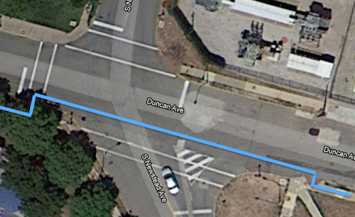
For this post I want to look at parts of five city blocks rather than just one; they’re bounded by 16th Street on the east, St. Charles St. on the north 18th on the west and Pine on the south. These blocks have a mix of buildings including rehabbed/occupied, non-rehabbed/occupied, vacant buildings, vacant land, a church, a non-public library building, etc.

I’ve organized them by City Block and listed the property addresses.
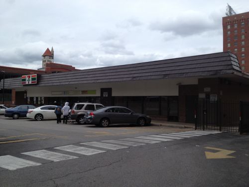
City Block 509

1700-1706 Olive was built in 1918, it is for sale
1700-1706 Olive was built in 1918, it is for sale. The facade on the base appears to have been modified later, possibly to fit in with the adjacent buildings. Click image for map.
1708 Olive, built in ???, is less than 24ft wide.
1708 Olive, built in 1951, is less than 24ft wide.
1710-1714 Olive, built in ???
1710-1714 Olive was built in 1946
1718 Olive (left) and 1720 Olive (right) are both occupied.
1718 Olive (left) and 1720 Olive (right) are both occupied. 1718 was built in 1900, 1720 in 1926.
1728 Olive was built in 1929

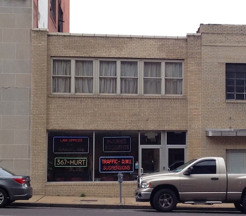
I like variety & scale of the buildings on this block facing Olive, but with the exception of 1700-06 Olive the density is too low to be on a streetcar line and not tall enough relative to the width of Olive. The two 3-story buildings in the middle might be able to be kept with new construction on either side. However, most of these buildings contribute to the Washington Ave national historic district so rehabilitation should be considered.

The rest of the block is surface parking for the Blu Condominium Association and a dumpy 7-11.
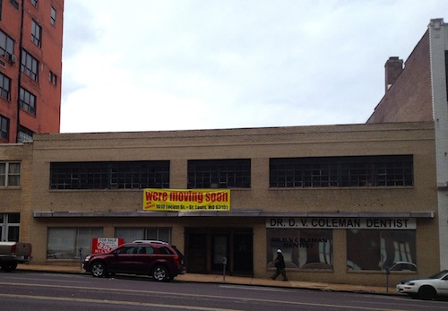
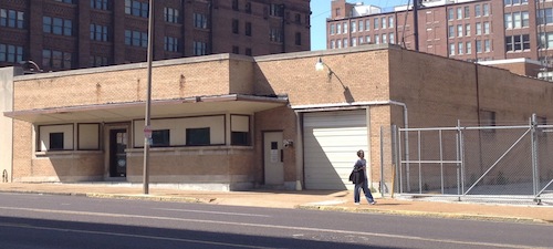
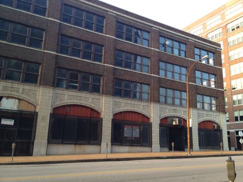
Even though the 7-11 faces 17th, the property address is 1701 Pine.

City Block 510

1717 Olive occupies the entire block. Originally the Butler Brothers warehouse built in 1908
1717 Olive occupies the entire block. Originally the Butler Brothers warehouse built in 1908, later renamed Plaza Square.

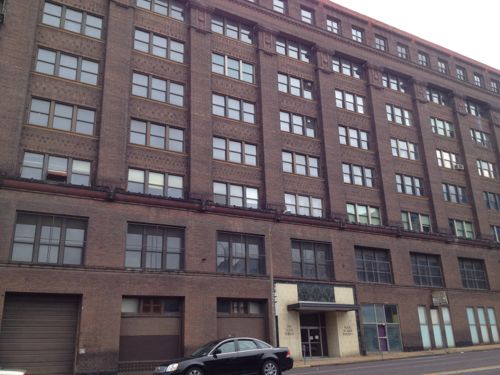
The building does have a few business tenants but overall it is in need of a major rehab. Because of the condition, the rents are low. Care should be taken to not price businesses out of the building/neighborhood. On the other hand, those of us living nearby would appreciate it if it was maintained to a higher standard.

This building has potential to house offices and residential.
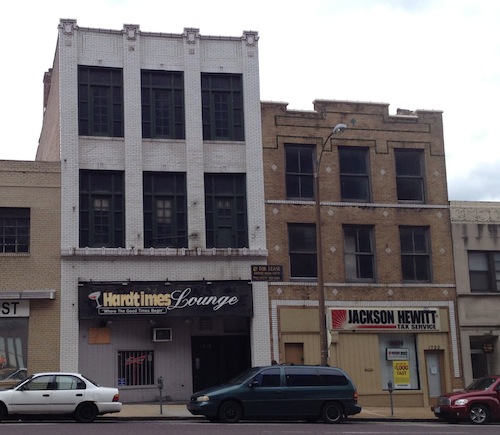
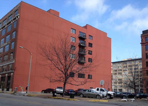
City Block 511

1601 Olive
1601 Olive is a 2-story office building built in 1965, it is vacant and for sale. I’d rather see a larger structure on this corner.
1613 Olive is a vacant lot owned by the city, used for parking.
1613 Olive is a vacant lot owned by the city, used for parking for the building to the west.
1621 Olive is owned by the city, used for parking enforcement offices right now
1625 Olive is privately owned and is occupied.  Built in 1948, it has an interesting facade. Retain the facade but build up?
1625 Olive is privately owned and is occupied. Built in 1948, it has an interesting facade. Retain the facade but build up?
1624 Locust is part of the St. Louis Library system
The 2-story building at 1610 Locust was built in 1917, next door is The Leather Trades Artist Lofts.

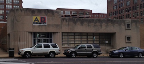
With the exception of the Leather Trades Artist Lofts, the block to very low in height and density. Although I don’t like the building heights, I do like the facades. Those facing Olive should probably be razed for taller structures.
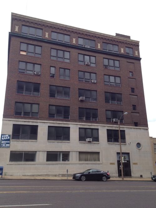
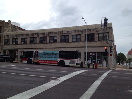
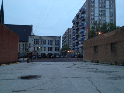
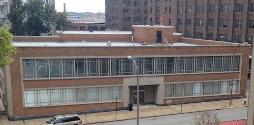
City Block 828

1601 Locust is a privately-owned surface parking lot next to Printers Lofts (1611 Locust). Loftworks had planned new construction to attach to Printers.
1601 Locust is a privately-owned surface public parking lot next to Printers Lofts (1611 Locust). Loftworks had planned new construction to attach to Printers. A great site for new construction.

Although I live in the Printers Lofts building, shown above, I don’t know the legality of building on the lot with respect to the four condos and our common space that face east. Presumably this is addressed in our condo documents and in the recorded information on the vacant lot. I’d love to see new construction on this corner, though my neighbors might object. The beautiful Blackwell-Wielandy building occupied the corner until it burned down in 1988.
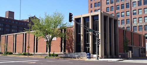
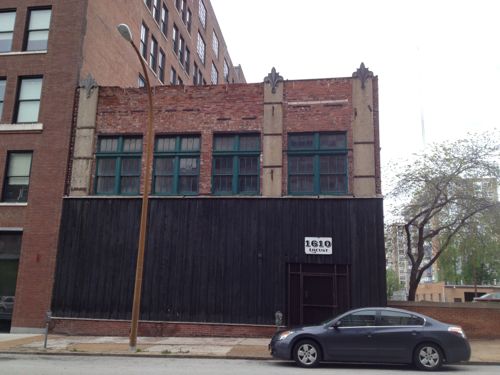
City Block 829

1701 Locust is a handsome 4-story building built in 1926. It has had several owners in the last decade. It is vacant.
1711 Locust was a power station for the original streetcar system, it is vacant and in disrepair.
1711 Locust was built in 1903 as a power substation for a private streetcar company, it is vacant and in disrepair. It was #5 on the Landmark’s 2010 Most Endangered List, click to view

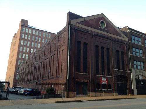
Both of these buildings are among my favorites. The substation is a creative challenge, but I’m sure someone could come up with a creative use for the space.

Closing thoughts…

Just in this small area there is room for lots of potential development over the next 10-20 years. In this type of exercise you look long-term at what the potential is for the coming decades. Some development will open before the streetcar line does, but most will come after that time. Developers will be eyeing the locations I’m highlighting in this series.

— Steve Patterson


Duncan Sidewalk Fixed, Crosswalk at Newstead Still A Problem

Today when I visit Solae it won’t be a challenge like it has been, last month I discovered a problem that existed since the building opened in 2008 has finally been fixed. Last July I posted about the problem and contacted Solae, Cortex and Washington University.

Here’s what it used to look like, the gap was nearly impossible to navigate:

ABOVE: Solae's contractor left a wide gap between old and new sidewalk on Duncan
Photo from July 2012 post: Solae’s contractor left a wide gap between old and new sidewalk on Duncan

It was suggested in the comments on my post last year that the adjacent building (shown above) owner was responsible. I rejected that idea because it was the construction work at Solae that created the gap that caused the problem. The architect and/or contractor didn’t consider patching the area where they had to over dig.

Now the sidewalk is passable.

Unfortunately, my trip from the Central West End MetroBus Transfer Center/MetroLink Station still has a major access problem. At Duncan & S. Newstead (map) I can’t use the crosswalk to cross Newstead.

The crosswalk exists but only if you can walk through grass and down a curb.
The crosswalk exists but only if you can walk through grass and down a curb, then jump a curb on the west side of Newstead.
Stepping back we can see the nearest ramp which id designed to cross Duncan, not Newstead
The blue line shows the route I take to cross Newstead
The opposite view shows the brick insert Washington University added to improve the pedestrian experience. Feb 2012 photo.
The opposite view shows one of the many decorative stamped concrete inserts Washington University added throughout their medical campus district to enhance the pedestrian experience. Feb 2012 photo.

Washington University spent considerable time and money on these decorative inserts, seemingly without thought to the functionality of the pedestrian network. This infuriates me beyond words. The money spent could’ve been used to make the area accessible and the sidewalks wide enough so when you meet someone they don’t have to step off the sidewalk into the grass. These decorative inserts are the type of pedestrian improvements are designed to look good on paper and driving by.

Can you imagine if roads were designed for aesthetics rather than function?

We’ll see how long it takes before I can use the crosswalk.

— Steve Patterson


Transit-Oriented Planning Eliminates 22nd Street Interchange, Reconnects Street Grid

For years I’ve been accused of being a naive dreamer, coming up with big plans without the existing market to implement. I’ve just smiled and continued sharing my long-term vision for St. Louis.

In June 2007 I wrote:

The 22nd Street Interchange, part of an abandoned highway concept from a few decades ago, needs to be ripped out with the land returned to active tax-paying use. The Missouri Dept of Transportation (MoDOT) should rework the interchange at Jefferson Ave to allow for on/off ramps in both directions and therefore eliminating the need for the current ramps at 22nd. MoDot could sell the land to fund the revisions to the highway ramps. (St. Louis Should Abandon Linear Gateway Mall Concept)

Then in December 2008 I wrote:

I picture a new bridge at I-64/40 and Jefferson Ave — one with a single point urban interchange (SPUI) and both East & West on/off ramps. Build that and then remove the 22nd interchange completely. Bring in form-based zoning codes to require a denser urban environment. Make a strong connection through the back of Union Station (between the shed & highway) so that pedestrians from this newly developable land have the opportunity to walk to Metrolink and the 14th street transit station beyond that. The fact that much of this area is already excavated and free of utility lines would simplify the construction of underground parking in new buildings. (MoDOT Needs To Put The 22nd Street Interchange On Any Wish List For Funding)

By May 2009 I noted that St. Louis’ 22nd Street Interchange Part of McKee’s Plan so it elimination would need to be worked out with him. Presumably MoDOT agrees with McKee because they’re replacing the Jefferson bridge over I-64/40 with no plans for on/off ramps to/from the east.

Then, last month, at an St. Louis Regional Transit Oriented Development Study presentation around the Union Station & Civic Center Metrolink stations the Denver-based consulting firm suggested largely what I had outlined years earlier.

Preliminary plan around Union Station, the Drury (former YMCA) and other existing buildings should be shown in the final presentation.

Ok, they still have on/off ramps for I-64/40 to the east, but they are compact and feed into the reconnected street grid I had advocated. The above image is preliminary, I pointed out it was missing buildings like the Drury Inn on 20th, formerly a YMCA and later a gay bar/hotel/bathhouse. Hopefully their final will be more accurate than the draft shown at the last meeting.

Still they see what I and others saw, the need to repair the street grid and fill in the gaps in the urban fabric.

Only part of a planned highway loop around downtown was built, a huge waste of land to the west of Union Station.
The 22nd Street interchange is just on/off ramps.
1958
1958 aerial of the area west & north of Union Station

This is not about trying to recreate the buildings and feel of the area prior to the demolition for the highway interchange. This is a forward-looking vision to create a walkable/urban environment for those interested in such. Some prefer the look & feel of new buildings, new sidewalks, new trees, etc. This is an opportunity to create an entirely new neighborhood largely from scratch yet have access to existing transit.

Per McKee’s plans, a few new employers could anchor the neighborhood. Workers & residents would attract restaurants, dry cleaners, and other services.

None of this is rocket science, it’s Urban Planning 101. St. Louis still needs lots of basics to rebuild the connections that were ripped out in the 20th Century.

— Steve Patterson


Readers on Infrastructure

As I expected, only a minority of readers live in a fantasyland where they think the public gets the infrastructure we want:

Pick the statement you agree with most:

  1. We get the infrastructure that makes developers the most money. 30 [42.25%]
  2. We get the infrastructure we want only if we fight for/demand better. 15 [21.13%]
  3. We get the infrastructure we get because most people don’t know other options exist. 12 [16.9%]
  4. We get the infrastructure that was commonplace years ago, but outdated today. 8 [11.27%]
  5. We get the infrastructure in our communities that most of us want and use. 5 [7.04%]
  6. Unsure/No Answer 1 [1.41%]

The rest of us know the so-called “free market” is limited by municipal zoning codes and time saver standards rather than creative thinking to respond to ever-changing demographics and preferences.

I should’ve had the top answer be one that costs developers the least rather than makes the most money, but you get the idea. To change this pattern we need to educate the public on other options so they’ll also demand better.

— Steve Patterson


My Wish List For The Next Saint Louis University President

Most likely you’ve already heard the news: Lawrence Biondi has announced he will retire as president of Saint Louis University.

The Rev. Lawrence Biondi surprised supporters and critics alike Saturday evening when he announced plans to retire from the presidency of St. Louis University.

The move follows months of campus strife that included no-confidence votes by faculty and students. (stltoday)

I’ve lived in St. Louis for nearly 23 years, most of Biondi’s 25-year tenure. I’ve witnessed the physical changes to the midtown campus along with everyone else. The public remains sharply divided on these changes. Some of us see the changes during his tenure as highly destructive and anti-urban, others view them as visionary, saving a once-dying campus.

Who’s right? Actually, both views are correct.

Biondi had a vision for the campus and was relentless in making it happen. Unfortunately, his vision was shaped by a perspective shared with many in his generation:

  1. Pedestrians stroll through park-like settings but use cars to actually get from point a to point b, pedestrians should be seperated from roads.
  2. Old urban cities are bad places with bad people, to be safe we must create physical barriers to keep them out of our space and to tell us where we shouldn’t go.
  3. Only poor people use public transit, everyone else has a car. In other words: transit brings troublesome poor folks while parking garages attracts desirable folks.
  4. Open space, with lush green lawns, solves problems.
  5. Residential, office, retail, industrial should all be separate from each other.

These views were formed in their youth, influenced by the General Motors Futurama exhibit at the 1939 World’s Fair.

The 1939 GM "Futurama" exhibit imagined intersection of 1960 with pedestrians separated from autos
The 1939 GM “Futurama” exhibit imagined intersection of 1960 with pedestrians separated from autos, click image to view 6 minute YouTube video from the 1939 New York World’s Fair (highly recommended)

My hope is the next president of Saint Louis University will reject the beliefs listed above. That he/she will instead think:

  1. The university should embrace the city, not wall it off.
  2. Supporting public transit will greatly reduce the need to take on debt to build more parking garages
  3. Thriving areas beyond campus will enrich the student experience
  4. SLU is an urban campus, the public rights-of-way (roads/sidewalks) within our boundaries should be highly active
SLU's anti-urban research building on the SE corner of Grand & Chouteau
SLU’s anti-urban research building on the SE corner of Grand & Chouteau

What is the likelihood the Board of Trustees will select someone with a viewpoint radically different from Biondi with respect to urban planning? Right, not very high…

— Steve Patterson


Advertisement


[custom-facebook-feed]

Archives

Categories

Advertisement


Subscribe