A study released this month looked at five regions and found a connection between home values and transit:
From the Executive Summary:
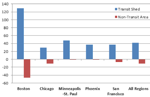
Overall there was a substantial decline in average residential sales prices in the study regions between 2006 and 2011. However, in all of the regions, the decline in average residential sales prices within the transit shed was lower than in the region as a whole or the non-transit area. Across the study regions, the transit shed outperformed the region as a whole by 41.6 percent. Figure 1 shows the percent change in average residential sales prices in the transit shed and non- transit area relative to the regional percent change in price.
Within a given region, heavy rail, light rail, and BRT transit sheds held their value best. In addition to having higher frequency service and better transit connectivity, these types of fixed-guideway transit stations also tend to be located in areas that are more walkable, have higher residential density, and better access to jobs. Commuter rail sheds also saw a smaller decline in average residential sales prices than the region as a whole.
Percent change in average residential sales prices relative to the region, 2006-11Click cover image to view the 39-page study from the American Public Transportation Association and the National Association of Realtors.
From the Conclusion:
Transit type also had an effect on the resilience of property values, which benefited more from transit that was well connected and had a higher frequency of service. Although most commuter rail transit sheds still saw a smaller decline in average residential sales prices than the region as a whole, heavy rail, BRT, and light rail transit sheds outperformed commuter rail transit sheds within and across regions. Heavy rail transit sheds had significantly higher levels of transit access, as measured by the Transit Connectivity Index and the Transit Access Shed, than the commuter rail sheds. Average monthly household transportation costs were also substantially lower in the heavy rail than the commuter rail sheds, indicating that the heavy rail sheds had not only higher levels of transit service, but were more location efficient overall. For most property types, the transit shed outperformed the region; however, unlike with transit type, there were no consistent trends across regions.
In addition to providing consumers and planners with information, the findings support investment in transit and encourage development in location efficient areas. The presence of fixed-guideway transit not only benefits individual property owners, it also supports a more resilient tax base.
I read about the study here. This is no surprise to many of us, but others won’t believe the results. “Everyone aspires to a McMansion in suburbia and driving everywhere” they’ll proclaim.
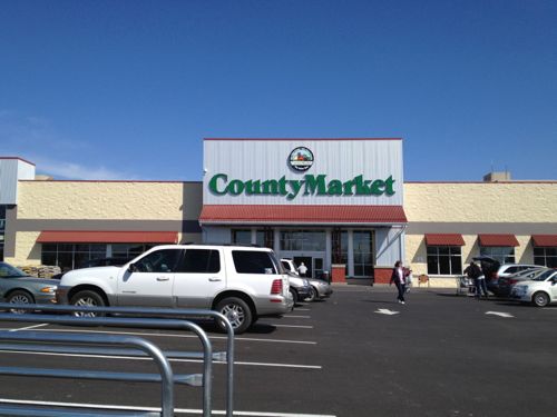
Recently a reader in Springfield IL, the Illinois state capital 90 miles from St. Louis, alerted me to a new County Market grocery store about to open on the NW edge of their downtown. A local newspaper article talked about the 11,000+ residents within a mile of downtown Springfield and 68,000+ within 5 miles. Tom Moore, director of the new store, was quoted:
“All day long, they come in and say, ‘When are you going to open?’” said Moore. “With the hospitals close by and the apartments close by, we’re expecting quite a bit of foot traffic here.“We’re targeting the whole downtown area, whether it’s the medical community or the neighborhoods.” (State Journal-Register)
Great, they recognize there are many people in the area and they expected lots of foot traffic. Memorial Medical is 2/10th of a mile to the north and St. John’s Hospital is a half mile directly east. County Market is a 100-store chain operated by Niemann Foods based in Quincy IL, an affiliate of Supervalu. Supervalu is the parent company of St. Louis-based chains Save-A-Lot and Shop ‘N Save. More on the new market later. Springfield’s Regional/Urban Design Assistance Team (R\UDAT) report from 2002 speaks briefly to making downtown pedestrian-friendly:
As a neighborhood, downtown Springfield should offer a pedestrian friendly environment with pleasant streetscapes, welcoming crosswalks, green space, or other “softscape” areas, parallel or diagonal parking as a buffer from vehicular traffic, adequate signage and easy to understand “way-finding” systems for visitors. The “way-finding” system should be easy to use, but should be somewhat unobtrusive in keeping with the neighborhood environment. Although the linkages are not yet established, the contiguous districts of commercial and historical importance in Springfield – the Lincoln home, the Capitol District – are very walkable from the central downtown core. A visitor will find it convenient to park in downtown Springfield and walk to these and other nearby attractions. Such programs as Lincoln Walks to Work and Looking for Lincoln will reinforce this walk-ability and contribute to the linkages between the downtown and the Lincoln home neighborhood. (Downtown as a Neighborhood)
In that same section they recognized the need to for additional retail to serve local needs, including a grocery store:
The retail mix should meet the needs of the downtown residents, the downtown employees, the residents in the neighborhoods surrounding downtown and downtown visitors and tourists. This mix should include coffee shops, gourmet retail and take out, bookstores, general grocery and merchandise, dry cleaners that offer bundle service, souvenir and general gift shops, ice cream, bakery and other service based businesses for residents. Bringing these uses into the downtown depends on achieving a larger resident population and the resulting greater purchasing power.
The Springfield Strategy 2020 report, completed in 2010, certainly says all the right things speaks more to making Springfield pedestrian-friendly:
“The Springfield of 2020 has preserved residential neighborhoods surrounding the downtown, which boosts pedestrian traffic in the downtown historic district and acts as a buffer to protect the downtown core.” (p23)“We believe that an effective transportation system must also include facilities to encourage biking and pedestrian traffic.” (p27)“The Springfield of 2020 will be pedestrian friendly with sidewalks being maintained, constructed and reconstructed when necessary throughout the city. This is but one way that the Springfield of 2020 will be know as a city that stresses better accessibility for all of its citizens.In addition, requirements for new subdivisions will be developed to encourage the development of amenities for walking and bicycling, as well as additional green space in all new subdivisions.” (p27)“The Springfield of 2020 will include bike paths downtown that have been sponsored and built by the city to encourage biking to area businesses and work places. The city will also develop new pedestrian walkways to encourage pedestrian traffic to historic and government sites so as to reduce downtown vehicular traffic and increase tourist use of area businesses.” (p27)
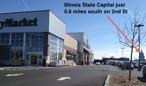
Great, Springfield seemed to know what was needed to achieve their objectives. Or not… The new County Market that’s expecting lots of pedestrians opened on March 8th, I visited on the 21st.
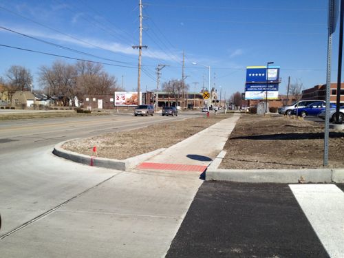
The main entrance faces west, with a surface parking lot between the 2nd Street public sidewalk and the door. No ADA accessible route is provided.
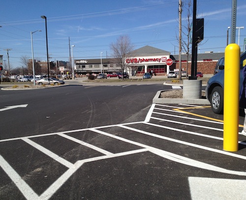
Remember, they’re expecting lots of foot traffic to this store. But 2nd Street is a minor road, Carpenter Street is a main arterial. But access is no better from that new public sidewalk.
Looking east on Carpenter St from the County Market auto drivewayA second entrance to County Market is located on the corner, facing Carpenter St. Seeing the marking on the pavement you might think that was to guide pedestrians safely to the public sidewalk.But it leads to disabled parking, not the sidewalk.
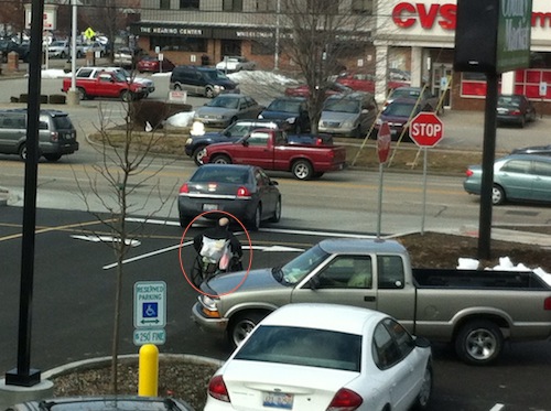
Again, they’re expecting lots of foot traffic yet they’ve made zero provisions for all these pedestrians to reach the store. Like so many places, the pedestrians will be forced to compete with the cars.
A customer in a manual wheelchair leaves the County Market via the auto exit on 3/8/2013, opening day. Photo by Steven Simpson-Black
Springfield wants to be pedestrian-friendly by 2020, but they allow this to happen? They also assembled the land and did a $2 million dollar TIF!
Planning and Economic Development Director Mike Farmer hopes it will act as a catalyst for further business growth near the city’s downtown and medical district.
Niemann Foods says 110 full and part-time staff have been hired from the area. The store’s floor plan and design has been called more “urban” than most County Market locations.
The smaller store features a coffee shop with drive-through window and upstairs lounge/dining area with free wireless internet access. A similar store has been built in the heart of the University of Illinois’ Champaign-Urbana campus. (WUIS)
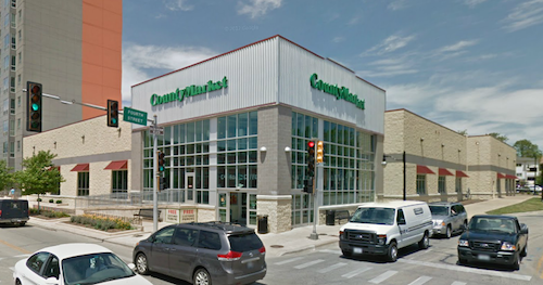
The County Market location at 331 E Stoughton St, Champaign, IL (Google Maps) has the same look, two entrances, and an upstairs — unfortunately that’s where the similarities end. Champaign’s corner entrance is on a different corner and placed at the intersection, while the main entrance faces a surface parking lot.
The secondary entrance to the County Market in Champaign IL helps define the street and welcomes pedestrians. Source: Google Maps/StreetvewThe main entrance in Champaign fronts onto another street with the parking lot on the opposite side. Source: Google Maps/Streetvew
The Champaign County Foods store lacks the two drive-through windows of Springfield — one for coffee and one for pharmacy. I’m pretty sure drive-through service windows decrease pedestrian traffic, not increase it.
Springfield & Niemann Foods had a chance to build a good urban prototype that would’ve been equally accessible by pedestrians and motorists, but they blew it big time. They need to at least provide an ADA Pedestrian Route from both Carpenter and 2nd Streets to each entrance.
Municipalities and businesses in the St. Louis region make the same mistakes too often.
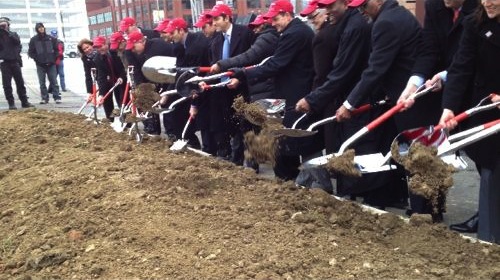
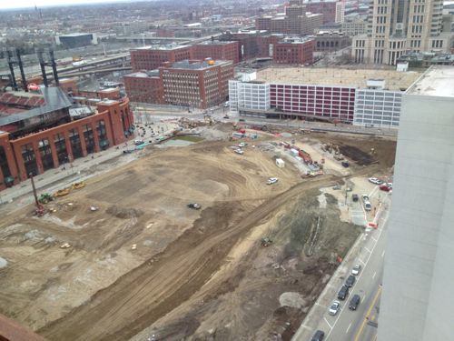
The groundbreaking for phase one of the long-delayed Ballpark Village project was held six weeks ago today (see post). Suits grabbed shiny shoves and tossed dirt placed neatly in front of the stage.
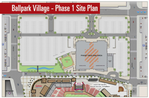
Years after Busch Stadium II was razed, the ground was broken on 2/8/2013 for Ballpark VillageABOVE: Site plan for BPV Phase 1 released 2/8/2013
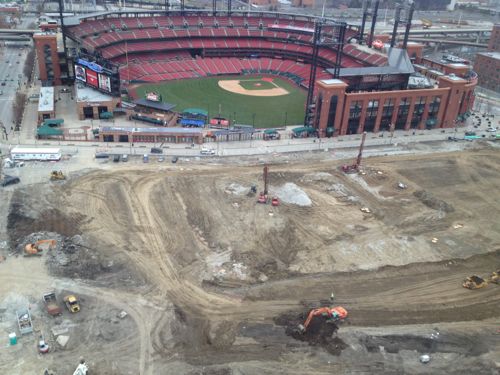
And yes, workers have been busy the last six clearing the site and prepping for the infrastructure needed to support all phases of the project. Here are a couple of views from Three Sixty taken on March 15, 2013:
Initial buildings to be opposite Busch Stadium Gate 5, center aboveLooking west toward the Stadium West garageABOVE: The former International Bowling Hall of Fame (background) and 7th Street from Clark Ave to Walnut St have been removed. Photo from October 2012.
Eighth St will become two-way up to Market Street, leaving just 5 blocks between Market & Washington as one-way southbound. Walnut St will also become two-way between 8th and Memorial Drive, leaving just four blocks from Tucker to 8th was one-way eastbound. Hopefully these scattered blocks won’t remain one-way.
Much of the talk about the proposed Downtown to CWE modern streetcar line has been focused on:
The use of streetcar vs bus
The east-west corridor vs investment in north & south St. Louis
How the proposed route mirrors the 1993 MetroLink route
How to end the line in the CWE, see post from yesterday here.
All valid topics, but today I want to zoom in to look at the route in the downtown central business district (CBD).
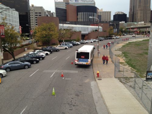
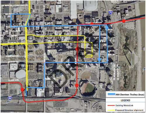
I added the existing #99 downtown trolley (blue) to the map of the proposed streetcar route
At this point in the streetcar process it isn’t known if the #99 Downtown Trolley bus route would remain, change or be eliminated completely. The draft report does note that operational savings could be realized through the elimination of a couple of bus routes. Eliminating the #99 would mean greater walking distances for service workers using transit since the proposed streetcar route has a more compact footprint, not a good thing for them.
East of 14th Street objectives that drove decisions regarding downtown alignments included:
Get as close as possible to the center of the employment concentration.
Minimize distance, physical and psychological, to major attractions, including the Arch Grounds.
Reduce capital and operating costs.
Minimize the number of curves to reduce noise and
increase speed.
Minimize the distance between tracks on one-way pairs. (The narrowness of the downtowtreets precludes double-track operation.)
Eliminate impacts to MetroLink from streetcar construction.
Lessen traffic impacts.
Application of those principles resulted, first, in the elimination of several options. Impacts to MetroLink during construction eliminated 8th Street and Washington Avenue. Traffic impacts, as cited by the City of St. Louis and the Missouri Department of Transportation, caused Broadway and 4th Street to be dropped, and the cost of extending the alignment from the downtown employment core to Memorial Drive eliminated that option.
This screening process resulted in a set of east-west streets that generally satisfied the evaluation criteria listed above. These included Chestnut, Pine, Olive and Locust Streets. North-south options were more limited and included 6th-7th Street and 9th-10th Street pairs. The former set was selected because it is closer to the heart of the downtown employment concentration and provides better proximity to major destinations. Olive Street is the logical eastbound half of an east-west one-way pair as it is a no-turn continuation of the alignment west of 14th Street. This results in a decision between Locust and Pine for the westbound segment. Locust was selected because of its centrality to the employment core, and because of its more pedestrian friendly first-floor uses, i.e., retail. Finally, the alignment south to Kiener Plaza addressed the strong desire from many stakeholders to provide direct and very visible pedestrian access to the Arch Grounds. (The plaza also provides a non-street layover point for streetcars.) In the next phase future coordination with the CityArchRiver 2015 project (draft study p14)
At Kiener Plaza a “layover point” is shown off street. This doesn’t fit with the latest concept for rebuilding Kiener Plaza. Such a change would need to be reviewed by the Gateway Mall Advisory Board, of which I’m a member.
Also not addressed is the use of 14th Street where it crosses the Gateway Mall (Market to Pine). Currently that is part of the “Civic Room” in the Master Plan. Currently 14th Street is frequently closed to traffic during major events like Taste of St. Louis and the Komen Race for the Cure. During these times the many bus routes that utilize 14th are rerouted on other streets but if 14th Street is used for the streetcar that means auto traffic may be rerouted but the streetcar needs to get through. This has major implications on the final design of the Civic Room and on event planning.
It was the relocation of the Saint Louis Law School that started all this, if Pine was used instead of Locust, that would be adjacent to the school. That said, I agree with the selection of Locust St. Yes, I live on Locust but at 16th so I won’t have a streetcar line directly in front of my building regardless.
It’s still early in the process but there’s lots to think about if this streetcar moves forward.
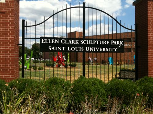
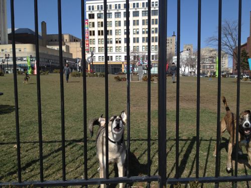
The northeast corner of Grand & Lindell, once an urban corner, is Saint Louis University’s Ellen Clark Sculpture Park. This large open site contains a number of sculptures that apparently please SLU President Lawrence Biondi.
ABOVE: The once vibrant urban street corner is now a passive hole in the city
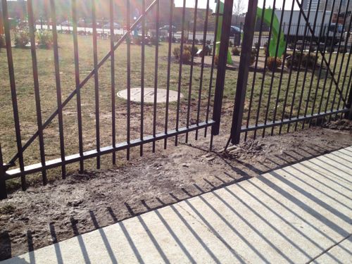
I’ve only seen the colorful sculptures from the public sidewalk surrounding the fenced space. It is open to the public but the design isn’t accessible to those of us using wheelchairs.
Bare dirt at both entrances is an invitation to get stuck. Even grassy areas can be a challenge for my power chair and nearly impossible for those in manual chairs.
I can walk with my cane if there was a way to get my chair inside the gates so I don’t have to leave it out on the sidewalk to risk being stolen. I’d think this sculpture garden should comply with the ADA due to #9 below:
Under the ADA public accommodations are private entities that own, lease, lease to or operate a place of public accommodation. This means that both a landlord who leases space in a building to a tenant and the tenant who operates a place of public accommodation have responsibilities to remove barriers.
A place of public accommodation is a facility whose operations affect commerce and fall within at least one of the following 12 categories:
Places of lodging (e.g., inns, hotels, motels, except for owner-occupied establishments renting fewer than six rooms)
Establishments serving food or drink (e.g. , restaurants and bars)
Places of exhibition or entertainment (e.g. , motion picture houses, theaters, concert halls, stadiums)
Places of public gathering (e.g. , auditoriums, convention centers, lecture halls)
Service establishments (e.g. , laundromats, dry-cleaners, banks, barber shops, beauty shops, travel services, shoe repair services, funeral parlors, gas stations, offices of accountants or lawyers, pharmacies, insurance offices, professional offices of health care providers, hospitals)
Public transportation terminals, depots, or stations (not including facilities relating to air transportation)
Places of public display or collection (e.g. , museums, libraries, galleries)
Places of recreation (e.g. , parks, zoos, amusement parks)
Places of education (e.g. , nursery schools, elementary, secondary, undergraduate, or postgraduate private schools)
Social service center establishments (e.g. , day care centers, senior citizen centers, homeless shelters, food banks, adoption agencies)
Places of exercise or recreation (e.g. , gymnasiums, health spas, bowling alleys, golf courses) (source)
b
The park also serves as a dog park
SLU installed a bag dispenser so dog owners can clean up and Biondi likes seeing dogs there.
“I am a dog lover,” said Biondi, who has an 8-year-old golden retriever named Iggy, in honor of St. Ignatius, founder of the Jesuit order. “But even if I didn’t love dogs, I’d still want the dogs in the park. It’s a nice opportunity for the community to get together and come to the campus and form friendships.” (stltoday.com)
Even as a dog park it has issues. If I were to try to enter the park there’s a risk someone’s dog might escape since no vestibule is provided.
Officially the entire corner is temporary, the university sought development proposals when the recession hit. Rather than make the park accessible I’d much prefer to see it get redeveloped. SLU has tons of open land, plenty of space exists to create another dog park nearby.
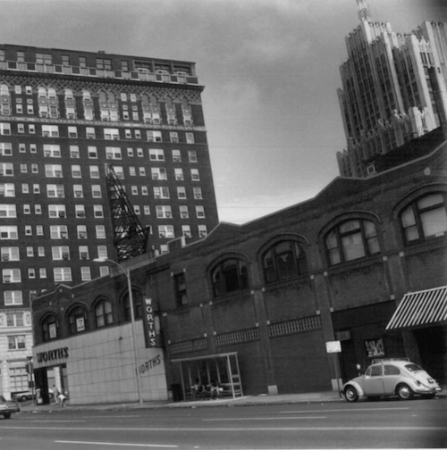
Marina Building August 1977
The historic Marina Building was only two stories high but a new building could be many more floors given the height of others in the area. I’d love to see a Trader Joe’s in the ground floor of a new building.
Here’s an interesting tidbit I ran across researching this post:
This year [2011] marks the sesquicentennial of the Camp Jackson massacre at this site, then known as Lindell Grove on the western edge of the city. On May 10, 1861, federal troops — already on edge and spooked by the sound of gunfire — fired into the crowd, killing 28 civilians, including several children, and wounding nearly 100 more. From 1929 to 1959 a monument to the event stood nearby, but it was banished when a descendant of Daniel M. Frost, general of the pro-Confederate Missouri militia, donated funds for Saint Louis University to purchase the midtown Frost Campus. Today, the site houses the Ellen Clark Sculpture Park, which is full of colorful abstractions reflective of Saint Louis University president Lawrence Biondi’s taste in art. Not even a small plaque commemorates the historic event or the two dozen-plus civilians who died here. (RFT Best Hidden Historical Site – 2011)
AARP Livibility Index
The Livability Index scores neighborhoods and communities across the U.S. for the services and amenities that impact your life the most
Built St. Louis
historic architecture of St. Louis, Missouri – mourning the losses, celebrating the survivors.
Geo St. Louis
a guide to geospatial data about the City of St. Louis