Home » St. Louis County » Recent Articles:

Ferguson, Missouri

The last events of last weekend were tragic, inspiring, confusing, and disappointing. Noon Saturday an unarmed young man, Michael Brown, 18, was shot by an unnamed Ferguson police officer, he died at the hospital. That night numerous protests & vigils were held. On Sunday evening more were planned, the family asked for them to be peaceful.

The photos & videos showed a large/vocal, but peaceful, crowd Sunday evening; likely the largest such event ever held in Ferguson.   I wasn’t there to see who & how it went from peaceful to lawless, including rioting, looting, and arson. Monday morning everyone is trying to make sense of the events, even though reconciling them is hard for most everyone.  Sadly, racist views often come out at times like these.

Yet we should all remember, looting & rioting takes place all over the world. It happens after major sporting events, natural disasters, and injustices. Some examples:

In 1979 people in San Francisco were upset with the light sentence Dan White received for shooting Mayor Moscone & Supervisor Milk:

Dan White, Milk’s assassin, was acquitted of murder charges and given a mild sentence for manslaughter, partly as a result of what became known as the “twinkie defense.” His attorney claimed that White had eaten too much junk food on the day of the killings and thus could not be held accountable for his crimes. He was sentenced to less than eight years in prison on May 21, 1979—the day before what would have been Milk’s 49th birthday—igniting what came to be known as the White Night Riots. Enraged citizens stormed City Hall and rows of police cars were set on fire. The city suffered property damage and police officers retaliated by raiding the Castro, vandalizing gay businesses and beating people on the street. (Harvey Milk Foundation)

From 1992:

German gangs smashed windows, looted shops and assaulted Dutch fans in 12 hours of violence surrounding Holland’s 3-1 victory over Germany in the European Championships in Goteborg, Sweden.

Riot police with horses and dogs repeatedly chased mobs of Germans through the center of Goteborg. The gangs dispersed and formed again, seeking openings through police lines to get at crowds of celebrating Dutchmen, but officers averted serious fighting.

Policeman Lasse Hansson said 23 were arrested, all Germans except for one Dutchman. He said charges against them included inciting riot, possession of weapons and resisting arrest. (Seattle Times)

Also in 1992, the LA Riots:

The LA Riots are mostly associated with the beating by police of Rodney King, but have a deeper and more complex background than that. We will start by looking at the background of Rodney King and the other causes to the LA Riots. (South Central History)

From 1998:

After the Denver Broncos defeated the Green Bay Packers to win Super Bowl XXXII, 10,000 fans went a little overboard and tears of joy became tear-gas-induced tears when people began flipping cars, looting and destroying the Mile High City. The Broncos’ victory and the following riot were selected as top news stories of 1998 by newspaper and broadcast members of the Associated Press. (source)

Earlier this year:

$25K in damage done to Historic century-old Pioneer Square pergola during out-of-control jubilation. About six people arrested after midnight when crowd began throwing bottles at police. Crazed students lit furniture on fire and made bonfires. Thousands throughout Seattle took to the streets to revel in the Seahawks’ victory, the city’s first major sports championship in more than 30 years. Drivers honked their horns, fans launched fireworks and at least one bonfire was blazing near the University of Washington. (NY Daily News)

But why?

The idea that people in crowds act differently — more violently, more passionately and perhaps, with a compromised moral compass — than individuals acting alone is not new. LeBon and Freud proposed it way back in early 20th century and others have since built on the theory.

But is that really the main motivation at play here?

Some, like Columbia University’s Tory Higgins don’t think so. Higgins, a professor of psychology who studies motivation, believes that riots such as the these typically occur when people feel “ineffective.” “In situations like this, there is a long period prior to the riot of feeling that you’re not in control of your own life. It may either be financial, like unemployment or a low-paying job, or political,” he says. “They basically don’t feel respected or that they’re making a difference.” (Huffington Post)

There’s so much we don’t know, particularly about the shooting on Saturday. Hopefully an impartial & transparent investigation will be conducted, and the community will accept the findings.

Burnt out QT at 9420 West Florissant on Monday Aug 11, 2014, 9:37am
The word "SNITCH.."  was painted on the sign
The word “SNITCHER” painted on the sign

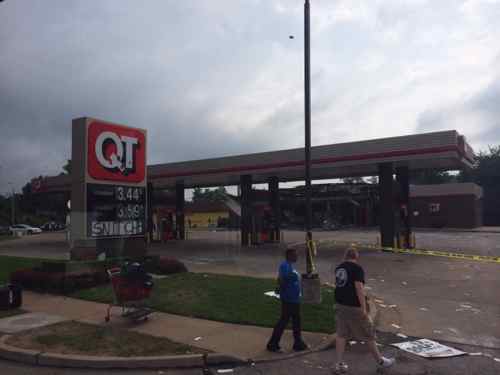
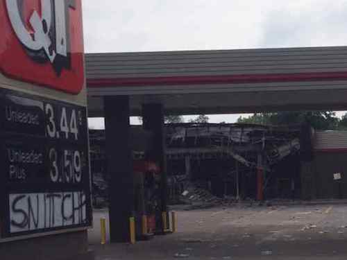
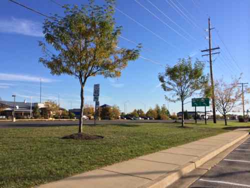
Why Quik Trip? It seems, based on internet hearsay, Michael Brown visited the store right before returning to the apartment complex where his grandmother lives.

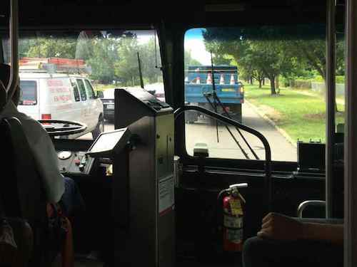
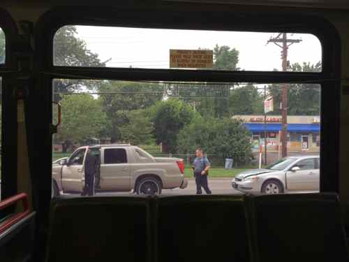
Yesterday I rode the #74 MetroBus from 14th & Washington north to St. Louis Community College — Florissant Valley and back. From the Quik Trip north, for 2 miles along West Florissant, I saw busted windows, shattered bus shelters, closed businesses, and police.   The Taco Bell my husband ate at in June, about a half mile north, had a busted window. The Walgreens at West Florissant & Chambers I passed in my wheelchair in April had a boarded window, and was closed. A guy on the return bus trip was saying the Walmart 2 miles north on West Florissant was closed.

Monday morning traffic was busy on West Florissant as people wanted to see the damage
We saw police investigating where a car had rear-ended a truck in the heavy traffic

The destroyed Quik Trip was built in 1989, I remember stopping there in the fall of 1990 on my way to visit a work supervisor who lived in the subdivision behind. QT may have been considering rebuilding the location, though they had likely updated the building in the last 25 years. It’s not hard to imagine Tulsa-based QT deciding to not rebuild this location.

The Walmart & Sam’s Club 2 miles north, both looted Sunday, were also built in 1989.

QT built this larger location at 10768 West Florissant in 2013, just off I-270
QT built this larger location at 10768 West Florissant in 2013, just off I-270, across from Walmart & Sam’s Club
The  McDonald's at 10873 West Florissant, built in 1993, was recently razed for a new building.
The McDonald’s at 10873 West Florissant, built in 1993, was recently razed for a new building.

The issues of the officer who shot Brown, the looters, etc should get resolved through investigation and the courts. The long-term implications for West Florissant can go any number of ways:

  1. Business owners see the looting as a one time thing and resume business as usual.
  2. Businesses remain but begin planning their exit strategy.
  3. Businesses don’t reopen.

Hopefully we’ve seen the worst of the rioting & looting. I want Michael Brown’s family to get the justice they seek.

— Steve Patterson


Accessing Yorkshire Village Shopping Center

In March I took MetroBus out to the suburban Yorkshire Village shopping center to meet my then-fiancé, now husband, for lunch. I hadn’t been in this area since I sold my car and the Sappington Farmers Market closed, both in 2012. Although the parking lot had been improved with planted islands in the last decade, I didn’t think a pedestrian access route existed. I’d looked at an aerial and at Google’s Street View, but I know for sure after a personal visit.

Google's Street View in March 2014 showed a spot where I could access the parking lot from the bus stop, no designated route. Click image for map link
Google’s Street View in March 2014 showed a narrow spot behind the bus shelter where I could access the parking lot, no designated route though. As of today the aerial is updated to show demolition of the old corner, the Street View remains the one I saw in March. Click image for map link

Based on a friend’s recommendation, we planned to meet at a newish place called Fuzzy’s Taco Shop, located on the far west end of the shopping center. When I arrived on March 21st what I encountered was very different than what I had expected, the entire corner of the old shopping center was gone, with a new building going up.

View from the bus stop
View from the bus stop, my only option was to head to Laclede Station to try to enter that way.
The construction zone separated the two wings, preventing me from reaching my destination that way. I ended up rolling along the Watson Rd shoulder until reaching an auto drive.
The new building is a CVS. Disclosure: we'd bought a small number of shares a month earlier when they announced they'd stop selling cigarettes.
The new building is a CVS. Disclosure: we’d bought a small number of shares of CVS a month earlier when they announced they’d stop selling cigarettes.
After lunch I got as close as I could to the construction, wondering if they'll provide an access route to the bus stop, connect the new separate buildings.
After lunch I got as close as I could to the construction, wondering if they’ll provide an access route to the bus stop, connect the now separate buildings.
When I passed by the new entry while on the shoulder I didn't see any evidence of a public sidewalk or access route to the shopping center
When I passed by the new entry while on the shoulder I didn’t see any evidence of a planned public sidewalk or access route to the shopping center
Across Watson waiting for a return bus you can see the overview.
Across Watson waiting for a return bus you can see the overview, and a pedestrian walking on the shoulder as I had to do.

It’s the suburbs and during construction everyone will be inconvenienced. My husband returned to Fuzzy’s a couple of times since our initial visit, after he said construction was completed we decided to meet again on Friday July 11, 2014. What would I encounter?

Looking west there was no public sidewalk along Watson
I was so pleased to see a proper access route, in concrete to contrast with the asphalt paving!
Looking inward I was so pleased to see a proper access route, in concrete to contrast with the asphalt paving! The planter helps to protect the route from vehicles.  Bravo!!
I quickly checked and found a great connection to the north building across the drive through lane
So I head west alongside the new CVS. so far so good.
And a connection to the west...but what's that I see?
And a connection to the west…but what’s that I see?
A new curb!?!
A new curb!?! Not sure who’s fault this is: engineer/architect, contractor, or owner, but someone screwed up an otherwise adequate access route.
I had to roll behind 13 parking spaces to reach a ramp, one car nearly backed into me.
Looking back from in front of the shops you can see the new concrete, this could've easily sloped to provide access.
Looking back from in front of the shops you can see the new concrete, this could’ve easily sloped to provide access. Again, nobody caught the mistake.

Had it been done right initially the cost would’ve been zero, no different than what they spent.  Did the drawings show it correctly but the contractor missed it? Why didn’t Webster Groves’ inspectors catch it? I can’t answer these questions but I’ll be emailing a link to this post to Matthew Stack at Koch Development Co and Webster Groves, the various parties can figure out who’s responsible for the costs to bust out the new concrete and redoing it correctly.

Koch Development originally built Yorkshire Village shopping center in 1951.

— Steve Patterson


‘Spanish Lake’ Documentary Overly Simplifies North St. Louis County In/Out Migration

Last week I finally saw the documentary ‘Spanish Lake’. Director Phillip Andrew Morton grew up in Spanish Lake, an unincorporated area of northeast St. Louis County. I suggest you see the film, showing at the Tivoli through July 3rd, but do so with a few grain of salt.

First, what the film got right:

  • St. Louis County leadership guided federal low-income housing to the area
  • St. Louis County has many municipalities
  • Nearby Blackjack was incorporated in an attempt to keep out low-income public housing
  • Real estate interests actively engaged in “blockbusting” and “steering”

If you take the film at face value you’ll walk away falsely thinking:

  • All residents from Pruitt-Igoe moved to brand new apartments in Spanish Lake
  • Spanish Lake would be perfect today if not for poor blacks moving in and quickly ruining things

The Spanish Lake area has a very long history, famed explorers Lewis & Clark camped here at the start and end of their trip (1804-1806), residents have lived in the area since. This was a rural farming community for many years, but in the 1920s new housing subdivisions were platted. Northdale, the subdivision where filmmaker Morton first lived, was among the first tract housing planned for Spanish Lake, it was platted in March 1929. The depression and World War II meant the subdivision were nothing more than a drawing on file with St. Louis County. . Northdale was platted for a parcel on the east side of a freight railroad line, Northdale 2 was platted just two weeks later, in March 1929, for the west side of the railroad line.

Before farmers began platting home sites on their property, in the City of St. Louis property owners were busy placing deed restrictions to keep non-whites from buying. One example from 1911 went all the way to the Supreme Court in the 1940s:

On February 16, 1911, thirty out of a total of thirty-nine owners of property fronting both sides of Labadie Avenue between Taylor Avenue and Cora Avenue in the city of St. Louis, signed an agreement, which was subsequently recorded, providing in part:
“. . . the said property is hereby restricted to the use and occupancy for the term of Fifty (50) years from this date, so that it shall be a condition all the time and whether recited and referred to as [sic] not in subsequent conveyances and shall attach to the land as a condition precedent to the sale of the same, that hereafter no part of said property or any
Page 334 U. S. 5
portion thereof shall be, for said term of Fifty-years, occupied by any person not of the Caucasian race, it being intended hereby to restrict the use of said property for said period of time against the occupancy as owners or tenants of any portion of said property for resident or other purpose by people of the Negro or Mongolian Race.”
The entire district described in the agreement included fifty-seven parcels of land. The thirty owners who signed the agreement held title to forty-seven parcels, including the particular parcel involved in this case. At the time the agreement was signed, five of the parcels in the district were owned by Negroes. One of those had been occupied by Negro families since 1882, nearly thirty years before the restrictive agreement was executed. The trial court found that owners of seven out of nine homes on the south side of Labadie Avenue, within the restricted district and “in the immediate vicinity” of the premises in question, had failed to sign the restrictive agreement in 1911. At the time this action was brought, four of the premises were occupied by Negroes, and had been so occupied for periods ranging from twenty-three to sixty-three years. A fifth parcel had been occupied by Negroes until a year before this suit was instituted. (Shelly v. Kraemer, 1948)

The 1948 decision meant the government courts couldn’t be used to enforce private restrictive covenants.  Real estate interests pounced on neighborhoods, playing up fears of whites that they’d better sell while they could. Go back up and reread the quote — black families had lived on that block for years. The big fear was going over a “tipping point” where all white neighborhoods would gain just enough non-whites to make the remaining whites leave; roughly 10%.  This has been the case for more than a century now.

1951
This is the house ‘Spanish Lake’ filmmaker Philip Andrew Morton lived in during the 80s, it was built in 1951

Presumably because of the Great Depression and WWII, the homes in Northdale weren’t built until 1951; each virtually identical 864 square foot slab on grade boxes (no basement). A decade later Northdale 2 homes were built on the lots platted the other side of the tracks. These homes were built in brick, with a full basement, and 3 bedrooms instead of just 2. Those early Northdale homes were the very cheapest new housing available, and with government loans cheaper than renting in the then-overcrowded city.

The now-dated Belle Parke Plaza strip mall was built in 1963 to serve the new residents
The 336-unit Spanish Gardens Apts/Colonial Meadows condos on Parker Rd were built in 1964, a decade before Morton says the blacks were moved from Pruitt-Igoe.
The 40-unit Kathleen Apts, shown in the film, were built in 1966

At the same time as the strip mall and initial apartment buildings were going up so were nicer homes, such as those in the Hidden Lake Subdivision behind the Spanish Gardens Apts and the Belle Parke Plaza strip mall. These houses face a private lake, are 1,500-2,000 sq ft  with 2-car garages.

Meanwhile…

The county had adopted a master plan in 1965 which embraced the 1,700 acres which were later to become the City of Black Jack. That plan designated sixty-seven acres for multiple-family construction. In 1970, 15.2 of those acres were occupied by 321 apartments, 483.1 acres were occupied by single-family dwellings, and the rest of the land was undeveloped. (source)

Apartments were planned before Congress changed the Urban Renewal program into Model Cities (1966).   Many many factors play into people’s decisions about where to live, when to move, etc… Yes, race may be a part of the decision; humans like to self-select to be with like individuals. Economics is another. For years General Motors had a factory in north city (Natural Bridge & Union), the Corvette was assembled there until 1981 when “production shifted from St. Louis, Missouri to Bowling Green, Kentucky” (Wikipedia). The entire plant was closed in 1987, but in 1983 a new plant opened in the St. Charles County town of Wentzville. The movement of blue collar jobs meant blue collar workers would follow.

Why keep living in a 30+ year old 2-bedroom 1-bath house without a basement or garage when you can get a newer & nicer home closer to work?   I’ll have more on the Spanish Lake area in the coming weeks, but I do suggest you get to the Tivoli to see it.

— Steve Patterson


Chesterfield Valley May Add Shelters At Inaccessible MetroBus Stops

June 9, 2014 Accessibility, Featured, Planning & Design, Public Transit, Retail, St. Louis County, THF Realty Watch, Walkability Comments Off on Chesterfield Valley May Add Shelters At Inaccessible MetroBus Stops

I applaud Chesterfield’s continued support of pubic transportation. Last week I read about more potentially good news:

Chesterfield’s City Council on Monday night gave initial approval an cooperation agreement between the city, Metro, and the Chesterfield Valley Transportation Development District for of bus stop shelters in Chesterfield valley and in other areas of the city in which there are Metro bus routes. A final vote on the legislation is set for June 16. (stltoday)

Bus shelters are an improvement, but what about getting to/from the shelters?

One of five MetroBus stops along Chesterfield Airport Rd serving retail in the Chesterfield Valley, just a sign on the shoulder
One of five MetroBus stops along Chesterfield Airport Rd serving retail in the Chesterfield Valley, just a sign on the shoulder (below highway 40 sign). Click image for map.
The other side of the same stop shows the grass that must be crossed to/from the stop. A sidewalk exists at this spot but not all stops have a sidewalk nearby.

I took these images in October when I checked out the area in a rental car. My conclusion was Chesterfield Valley is an ADA nightmare, taking MetroBus to shop wouldn’t be possible in a wheelchair. Given that everything was built since the big flood of 1993, it should be ADA-compliant.  I checked Chesterfield’s ADA Transition Plan, there’s no mention of their responsibility in the public right-of-way.

I’d love to meet former Chesterfield Mayor & Metro President John Nations and current mayor Bob Nation at one of these MetroBus stops to have them see the challenges the transit-using public, including the able-bodied, face in navigating this area on foot.

— Steve Patterson


Neighborhood Retail In Older Suburbs

Driving around the inner ring suburb of Overland recently I was struck at the number of corner retail buildings adjacent to the residential streets. Unlike more recent suburbs, where retail is miles away from housing, these were very close. End of street close. Today when we think of retailing in the suburbs it’s easy to assume it was always big boxes or enclosed mall, but like the inner city, it started off with stores within walking distance.

Lackland at Ashby, click for map
This storefront building facing Lackland, just east of Ashby, was built in 1950. Click for map
This building was built in 1952, to the east of the previous.
The 1952 building even included a 2-story section
Most of the housing in this area are modest one-story  homes from the 1920s-1960s, this house across the street was built in 1844
Most of the housing in this area are modest one-story homes from the 1920s-1960s, this house directly across Lackland was built in 1844
The commercial building a block east, at 10236 Lockland, was built in 1936. I don't know the prior uses, my guess was a market.
The commercial building a block east, at 10236 Lockland, was built in 1936. I don’t know the prior uses, my guess was a market.
The 21,000+ square foot commercial building at Lackland Rd & Bryant Ave was built in 1947

This is far different than the 1960s subdivision in Oklahoma City where I grew up. The 1960s subdivisions I’ve seen here are very similar, by that time commercial development was further away  and with lots more parking than these examples. Suburbs & their subdivision development seemed to continue on this trajectory, except for New Urbanist developments like New Town St. Charles.

— Steve Patterson


Advertisement


[custom-facebook-feed]

Archives

Categories

Advertisement


Subscribe