Nineteen year ago I started this blog as a distraction from my father’s heart attack and slow recovery. It was late 2004 and social media & video streaming apps didn’t exist yet — or at least not widely available to the general public. Blogs were the newest means of …
The new NGA West campus , Jefferson & Cass, has been under construction for a few years now. Next NGA West is a large-scale construction project that will build a new facility for the National Geospatial-Intelligence Agency in St. Louis, Missouri.This $1.7B project is managed by the U.S. Army …
Book publisher Island Press always impresses me with thoughtful new books written by people working to solve current problems — the subjects are important ones for urbanists and policy makers to be familiar and actively discussing. These four books are presented in the order I received them. ‘Justice and …
This post is about two indirectly related topics: the new Siteman Cancer Center building under construction on the Washington University School of Medicine/BJC campus and an update on my stage 4 kidney cancer. Let’s deal with the latter first. You may have noticed I’ve not posted in three months, …
Rarely does the “unsure/no answer” option go unselected in the weekly poll, but last week the voting was higher than usual with 145 total votes and everyone had an opinion about their favorite commercial street in St. Louis. Here are the results:
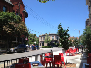
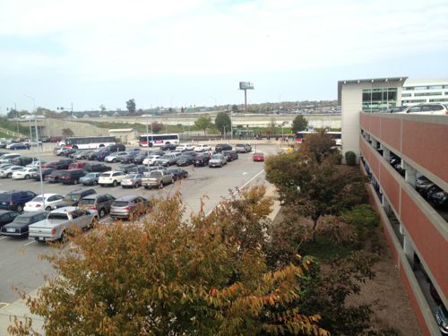
The intersection of Euclid & McPherson in the CWE
Q: Pick your favorite commercial street in St. Louis city
Euclid (CWE) 32 [22.07%]
Grand (South Grand) 25 [17.24%]
Delmar (Loop) 23 [15.86%]
Cherokee Street 20 [13.79%]
Washington Ave 17 [11.72%]
Other: 11 [7.59%]
Manchester Ave (The Grove) 8 [5.52%]
Morgan Ford 5 [3.45%]
Locust St (Midtown Alley) 3 [2.07%]
N. 14th Street (Old North) 1 [0.69%]
Unsure/No Answer 0 [0%]
As I said in the post introducing the poll, I’m thrilled there are so many choices.
In hindsight I should’ve 1) noted I meant a commercial street with organized marketing effort 2) defined what a commercial street is and isn’t, 3) allowed 2-3 selections rather than just one, and 4) included a few of the ones below submitted by readers:
DeMun Neighborhood West of Clayton
Ivanhoe
Macklind
manchester ave
the Loop and South Grand tie for me
Castleman Circle (Shaw & Vandeventer)
Manchester (Maplewood)
Gravois
Mackland
Truman Parkway
Hampton Avenue
Ivanhoe & Macklind are the two I wish I had included. DeMun is an interesting area…in Clayton, not the city. Interestingly nobody added say 2nd Street in Laclede’s Landing.
How did Euclid in the CWE edge out South Grand, Delmar Loop, and Cherokee? Probably a number of factors but the main one is likely the first mover advantage. It was Euclid Ave that convinced me to move to St. Louis in 1990, at the same time the other streets were nothing like they are today.
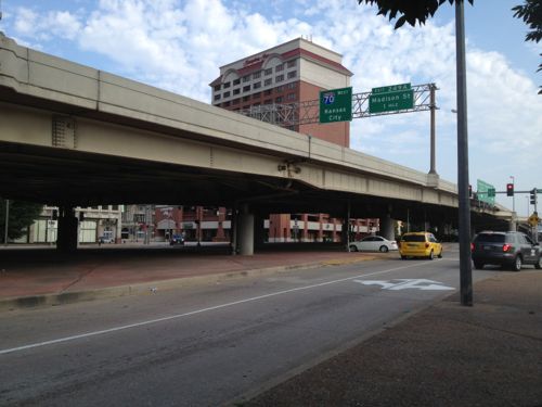
The CityArchRiver 2015 effort has been about connecting the city to the Arch and to the river. But I think the name needs an asterisks, followed by a legal disclaimer in fine printer.
Plans call for altering the vehicular & pedestrian flow under the elevated highway at the NW corner of the Arch grounds. but it’ll remain a divider.
The disclaimer would read something like this:
*The connection will be applicable for a block or two at the center of the Arch grounds, the north & south portions will remain disconnected. We’ll make a few token changes, nothing significant.
I agree there isn’t time now to raze the elevated highway and complete an urban boulevard before October 28, 2015, but I’d like to see us work on starting shortly after the 50th anniversary of the last piece of the Arch. If we start now we can have the urban boulevard by the 75th anniversary on October 28, 2040.
Only after this is removed will downtown be reconnected to the Mississippi River in a meaningful way.
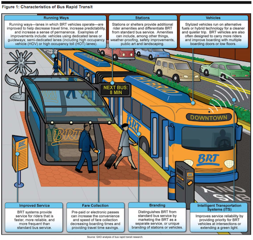
Bus Rapid Transit (BRT) has been used effectively in cities all over the world to improve public transit service, over previous bus service. With the proposed St. Louis Streetcar now going through the approval process some have suggested BRT as a less costly alternative. Seemed like a good reason to begin looking at the similarities and differences.
Similarities between BRT and modern streetcar:
Fewer stops than standard bus service, but more often than light rail
Faster on dedicated lanes, but can run in lanes stared with traffic
Unique branding that is distinct from local bus service
Higher capacities than bus service, though it varies depending upon the BRT vehicle
Increased ridership and development over bus
Differences between BRT and modern streetcar:
BRT can be re-routed, though stops are not changed easily. Streetcar routes unlikely to change due to capital costs.
Tracks & wires convey the message of transit even when vehicle not present, BRT is easier to ignore.
Many service enhancements are optional with BRT, thus BRT lite. These are not optional with streetcars.
Streetcar vehicles have a significantly longer service life than BRT vehicles.
Few can even agree on what minimum combination of service enhancements are necessary to be called BRT, the US Government Accountability Office says, “BRT generally includes improvements to seven features–running ways, stations, vehicles, intelligent transportation systems, fare collection, branding, and service.”
Source: United States Government Accountability Office’s July 2012 report “BUS RAPID TRANSIT Projects Improve Transit Service and Can Contribute to Economic Development” page 6, click to download PDF
Fare collection for standard buses is done as each passenger boards, whereas light rail systems use off-siteboard fare collection to reduce total boarding time. Modern streetcars, like light rail, tend to also use off-siteboard fare collection or on-board payment from one of several machines, allowing for faster boarding
Here’s a summary of what the GAO found out about BRT in the US:
U.S. bus rapid transit (BRT) projects we reviewed include features that distinguished BRT from standard bus service and improved riders’ experience. However, few of the projects (5 of 20) used dedicated or semi-dedicated lanes— a feature commonly associated with BRT and included in international systems to reduce travel time and attract riders. Project sponsors and planners explained that decisions on which features to incorporate into BRT projects were influenced by costs, community needs, and the ability to phase in additional features. For example, one project sponsor explained that well-lighted shelters with security cameras and real-time information displays were included to increase passengers’ sense of safety in the evening. Project sponsors told us they plan to incorporate additional features such as off-board fare collection over time.
The BRT projects we reviewed generally increased ridership and improved service over the previous transit service. Specifically, 13 of the 15 project sponsors that provided ridership data reported increases in ridership after 1 year of service and reduced average travel times of 10 to 35 percent over previous bus services. However, even with increases in ridership, U.S. BRT projects usually carry fewer total riders than rail transit projects and international BRT systems. Project sponsors and other stakeholders attribute this to higher population densities internationally and riders who prefer rail transit. However, some projects—such as the M15 BRT line in New York City—carry more than 55,000 riders per day.
Capital costs for BRT projects were generally lower than for rail transit projects and accounted for a small percent of the Federal Transit Administration’s (FTA) New, Small, and Very Small Starts’ funding although they accounted for over 50 percent of projects with grant agreements since fiscal year 2005. Project sponsors also told us that BRT projects can provide rail-like benefits at lower capital costs. However, differences in capital costs are due in part to elements needed for rail transit that are not required for BRT and can be considered in context of total riders, costs for operations, and other long-term costs such as vehicle replacement.
We found that although many factors contribute to economic development, most local officials we visited believe that BRT projects are contributing to localized economic development. For instance, officials in Cleveland told us that between $4 and $5 billion was invested near the Healthline BRT project—associated with major hospitals and universities in the corridor. Project sponsors in other cities told us that there is potential for development near BRT projects; however, development to date has been limited by broader economic conditions—most notably the recent recession. While most local officials believe that rail transit has a greater economic development potential than BRT, they agreed that certain factors can enhance BRT’s ability to contribute to economic development, including physical BRT features that relay a sense of permanence to developers; key employment and activity centers located along the corridor; and local policies and incentives that encourage transit-oriented development. Our analysis of land value changes near BRT lends support to these themes. In addition to economic development, BRT project sponsors highlighted other community benefits including quick construction and implementation and operational flexibility.
Here are more quotes from the same report:
Operating costs:
We also heard from stakeholders and project sponsors that operating costs for BRT and rail transit depend strongly on the density and ridership in the corridor. For example, according to one transit expert, while signaling and control costs are high for rail transit, there is a tipping point where given a high enough density and ridership, rail transit begins to have lower operating costs overall. (p31)
Land-Use:
BRT project sponsors and experts we spoke to told us that transit- supportive policies and development incentives can play a crucial role in helping to attract and spur economic development. Local officials in four of our five site-visit locations described policies and incentives that were designed (or are being developed) to attract development near BRT and other transit projects. For example, Los Angeles city officials told us that the city’s mayor recently created a transit-oriented development cabinet tasked with improving and maintaining coordination between Los Angeles Metro and city staff and developing policies and procedures in support of transit-oriented developments. They told us that the city is currently working on lifting requirements that require large amounts of parking and allow for only one- or two-story developments along many of the Metro Rapid lines. Officials in Eugene, Cleveland, and Seattle also told us that local governments either have in place, or are currently drafting, land use policies that are supportive of transit-oriented development. (p38)
Economic development:
Stakeholders also mentioned several factors that could lead to different amounts and types of economic development in BRT corridors compared to rail transit corridors. For instance, the greater prestige and permanence associated with rail transit may lead to more development and investment in rail transit corridors than in BRT corridors. Transit agency and other local officials also noted that BRT station areas might experience less investment and development than rail station areas because transit agencies may not own large amounts of land around BRT stations on which to build or support transit-oriented developments.43 Los Angeles city officials told us that one of the primary economic development benefits of light rail is that surplus property around the stations can be developed. Kansas City ATA officials told us that the agency owns only a few properties along Troost Avenue, which limits its ability to incentivize economic development in and around the BRT corridor. One real estate expert we spoke with noted that BRT may be better at supporting small- scale retail and residential developments, affordable housing developments, and medical facilities than rail transit, since these types of developments are often priced out of rail station-area markets. (p38-39)
This GAO report goes into great detail comparing BRT to light rail, but what about BRT vs modern streetcars? For that we can look at ongoing debate in the Washington DC suburb of Arlington VA:
The pro-streetcar group, Arlington Streetcar Now, wants to see the proposed streetcar become a reality on Columbia Pike between Pentagon City and Bailey’s Crossroads in Fairfax County (and potentially beyond), as well as a future streetcar from Pentagon City to Crystal City and then Potomac Yard in Alexandria.
It counters another new group, Arlingtonians for Sensible Transit, which launched in January. Its supporters say they want Arlington to study a “modern Bus Rapid Transit (BRT) system” along the Pike. (source)
Much has been written about streetcar vs BRT on the corridor they seek to improve. A good friend, and Arlington resident, thinks the streetcar idea is “stupid” and the proponent “arrogant.” My friend also likes living very close to a Metro station, which was far costlier than any streetcar, BRT or light rail.
The debate continues….
Even though a streetcar has significantly lower capital costs than a subway system, it is still a larger investment than a BRT system, sometimes costing twice as much. For example, Arlington’s Columbia Pike streetcar’s capital costs are around $51M/mile while Lansing’s Michigan/Grand River BRT is around $24M/mile (based on estimates found on their websites). However, streetcar systems bring with them benefits that BRT systems cannot leverage. Streetcars carry more passengers, more quickly, and they attract more “choice riders” and tourists, people who typically don’t feel comfortable riding a bus. Also, streetcars signal to the private sector that that corridor is important to the community; the predictability of transit service can bring increased economic development, thereby increasing local tax revenue, and garnering various community benefits. An commensurate increase in density can create places that enable people to drive less and walk, bike and ride transit more often. (source)
I like full BRT service and BRT lite over standard bus service, but neither have the potential to generate new high-density development the way streetcars can. Regardless of mode, BRT or streetcar, other factors such as good land-use regulations are an important factor in seeing development over the long-term. We skipped this important step when we opened our initial light rail line nearly 20 years ago, and along later expansions. We must get the land-use part right this time.
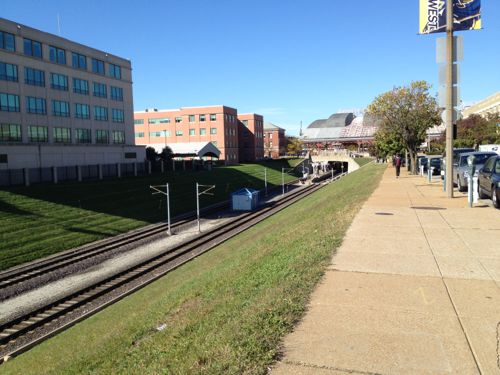
Looking west toward the Union Station MetroLink Station from 16th & Clark. The offices on the left aren’t oriented to transit, just adjacent.
The only thing at the North Hanley station is 1,583 parking spaces (926 surface, 657 in garage)
Not much exists around the Wellston Station, the jobs center in the background is hard to reach on foot, easy by car though
The poll this week lists many possible reasons why development hasn’t happened around the stations, you can pick up to 3. The choices are presented in random order.
On July 31st, MetroLink’s 20th anniversary, I’ll share my thoughts on why development hasn’t happened and what we need to do so the next 20 years are more productive.
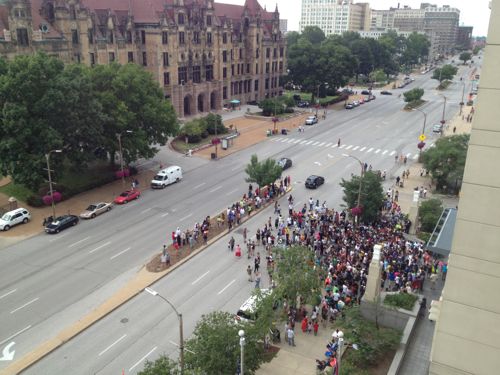
Last Sunday a couple hundred people showed up at the St. Louis Justice Center to rally against the acquittal of George Zimmerman in the February 26, 2012 shooting death of Trayvon Martin.
St. Louisans gathered peacefully outside the Justice Center on Sunday July 14th
Across the country today more demonstrations will be held at federal courthouses. “The St. Louis gathering will take place at 12 noon at the Thomas F. Eagleton U.S. Courthouse (111 South 10th Street St. Louis, MO 63102).” (source)
I’m not going to say anything else, I just ask that commenters be respectful to others.
AARP Livibility Index
The Livability Index scores neighborhoods and communities across the U.S. for the services and amenities that impact your life the most
Built St. Louis
historic architecture of St. Louis, Missouri – mourning the losses, celebrating the survivors.
Geo St. Louis
a guide to geospatial data about the City of St. Louis